- Middlesex
-
For other uses, see Middlesex (disambiguation).
Middlesex 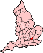
Ancient and 1889 extent of MiddlesexGeography Status Ceremonial county (until 1965)
Administrative county (1889–1965)1801/1881 area 181,320 acres (734 km2)[1] 1911 area 148,701 acres (601.8 km2)[2] 1961 area 148,691 acres (601.7 km2)[2] HQ see text Chapman code MDX History Origin Middle Saxons Created In antiquity Succeeded by 1889: part to County of London
1965: Greater London and
parts to Surrey and HertfordshireDemography 1801 population
- 1801 density818,129[1]
4.5/acre1881 population
- 1881 density2,920,485[1]
16.1/acre1911 population
- 1911 density1,126,465[2]
7.6/acre1961 population
- 1961 density2,234,543[2]
15/acrePolitics Governance Middlesex County Council (1889–1965) 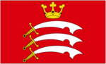
Banner of arms of Middlesex County CouncilSubdivisions Type Hundreds (ancient) Middlesex (
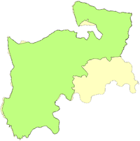
 /ˈmɪdəlsɛks/) is one of the historic counties of England and the second smallest by area.[3] The low-lying county contained the wealthy and politically independent City of London on its southern boundary and was dominated by it from a very early time.[4] The county was significantly affected by the expansion of the metropolitan area of London in both the 18th and 19th centuries, such that from 1855 the south-east was administered as part of the metropolis.[5] When county councils were initially introduced in England in 1889 about 20% of the area of Middlesex, along with a third of its population, was transferred to the County of London, and the remainder formed a smaller county, in the north-west, under the control of Middlesex County Council.[6]
In the interwar years urban London had further expanded, with increasing suburbanisation, improvement and expansion of public transport,[7] and the setting up of new industries outside the inner London area. After the Second World War, the population of the County of London[8] and inner Middlesex was in steady decline, with new population growth only experienced in the outer suburbs.[9] After a Royal Commission on Local Government in Greater London, almost all of the original area was incorporated into an enlarged Greater London in 1965, with small parts transferred to neighbouring Hertfordshire and Surrey.[10] Despite the disappearance of the county council, Middlesex is still used as an area name and was retained as a postal county; which is now an optional component of postal addresses.[11]
Contents
History
Toponomy
The name means territory of the middle Saxons and refers to the tribal origin of its inhabitants. The word is formed from the Anglo-Saxon, i.e. Old English, 'middel' and 'Seaxe'.[12] Its first recorded use was in 704 as Middleseaxan.
Early settlement
Further information: List of places in Middlesex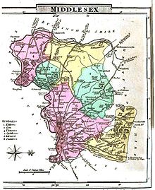 Map of Middlesex, 1824
Middlesex was recorded in the Domesday Book as being divided into the six hundreds of Edmonton, Elthorne, Gore, Hounslow (Isleworth in all later records),[13] Ossulstone and Spelthorne. The City of London, which has been self-governing since the thirteenth century, was geographically within the county, which also included Westminster, which had a high degree of autonomy. Of the six hundreds, Ossulstone contained the districts closest to the City of London. During the 17th century it was divided into four divisions, which, along with the Liberty of Westminster, largely took over the administrative functions of the hundred. The divisions were named Finsbury, Holborn, Kensington and Tower.[14] The county had parliamentary representation from the 13th century. The title Earl of Middlesex was created twice, in 1622 and 1677, but became extinct in 1843.[15]
Economic development
The economy of the county was dependent on the City of London from an early time and was primarily agricultural.[4] All manner of goods were provided for the City, including crops such as grain and hay, livestock and building materials. Tourism in early resorts such as Hackney, Islington and Highgate also formed part of the early economy. However, during the 18th century the inner parishes of Middlesex started to function as suburbs of the City and were increasingly urbanised.[4]
The introduction of radial railway lines from 1839 caused a fundamental shift away from agricultural supply for London towards large scale house building.[16] Tottenham, Edmonton and Enfield in the northeast developed first as working class residential suburbs with easy access to central London. The line to Windsor through Middlesex was completed in 1848, to Potter's Bar in 1850 and the Metropolitan and Metropolitan District Railways started a series of extensions into the county in 1878. Closer to London, the districts of Acton, Willesden, Ealing and Hornsey came within reach of the tram and bus networks, providing cheap transport to central London.[16]
Following World War I, the availability of labour and proximity to London made areas such as Hayes and Park Royal ideal locations for the developing new industries.[16] New jobs attracted more people to the county and the population continued to rise, reaching a peak in 1951.
Governance
The Metropolis
Further information: Population of Middlesex (1801–1881)By the 19th century, the East End of London had expanded to the eastern boundary with Essex, and the Tower division had reached a population of over a million.[1] Following the coming of the railways, the north western suburbs of London steadily spread over large parts of the county.[7] The areas closest to London were served by the Metropolitan Police from 1829 and, from 1840, the entire county was included in the Metropolitan Police District.[17] Local government in the county was unaffected by the Municipal Corporations Act 1835, and civic works continued to be the responsibility of the individual parish vestries or ad hoc improvement commissioners.[18][19] In 1855, the parishes of the densely populated area in the south east, but excluding the City of London, came within the responsibility of the Metropolitan Board of Works.[5] Despite this innovation, the system was described by commentators at the time as one "in chaos".[6] In 1889, under the Local Government Act 1888, the metropolitan area of approximately 30,000 acres (120 km2) became part of the County of London.[15] The Act also provided that the part of Middlesex in the administrative county of London should be "severed from [Middlesex], and form a separate county for all non-administrative purposes".
 Map showing boundaries of Middlesex in 1851 and 1911. Aside from minor realignments, the area to the north is Monken Hadley, transferred to Hertfordshire in 1889, and that to the SE is the area transferred to the County of London.
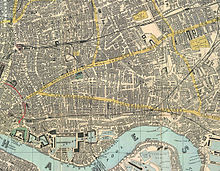 Map in 1882 shows complete urbanisation of the East End
The part of the County of London that had been transferred from Middlesex was divided in 1900 into 18 metropolitan boroughs, which were merged in 1965 to form seven of the present-day inner London boroughs:
- Camden was formed from the metropolitan boroughs of Hampstead, Holborn and St Pancras
- Hackney was formed from the metropolitan boroughs of Hackney, Shoreditch and Stoke Newington
- Hammersmith (known as Hammersmith and Fulham from 1979) was formed from the metropolitan boroughs of Hammersmith and Fulham
- Islington was formed from the metropolitan boroughs of Finsbury and Islington
- Kensington and Chelsea was formed from the metropolitan boroughs of Chelsea and Kensington
- Tower Hamlets was formed from the metropolitan boroughs of Bethnal Green, Poplar and Stepney
- The City of Westminster was formed from the metropolitan boroughs of Paddington, St Marylebone and the City of Westminster.[5]
Extra-metropolitan area
Further information: History of local government districts in MiddlesexMiddlesex outside the metropolitan area remained largely rural until the middle of the 19th century, and so local government was slow to develop. Other than the Cities of London and Westminster, there were no ancient boroughs.[20] The importance of the hundred courts declined, and such local administration as there was divided between "county business" conducted by the justices of the peace meeting in quarter sessions, and the local matters dealt with by parish vestries. As the suburbs of London spread into the area, unplanned development and outbreaks of cholera forced the creation of local boards or improvement commissioners to govern the growing towns. In rural areas, parishes began to be grouped for different administrative purposes. From 1875 these local bodies were designated as urban or rural sanitary districts.[21]
Following the Local Government Act 1888, the remaining county came under the control of Middlesex County Council except for the parish of Monken Hadley, which became part of Hertfordshire.[22] The area of responsibility of the Lord Lieutenant of Middlesex was reduced accordingly. Middlesex did not contain any county boroughs, so the county and administrative county (the area of county council control) were identical.
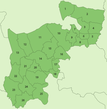
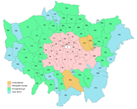
The Local Government Act 1894 divided the administrative county into four rural districts and thirty-one urban districts, based on existing sanitary districts. One urban district, South Hornsey, was an exclave of Middlesex within the County of London until 1900, when it was transferred to the latter county.[23] The rural districts were Hendon, South Mimms, Staines and Uxbridge. Because of increasing urbanisation these had all been abolished by 1934.[10] Urban districts had been created, merged, and many had gained the status of municipal borough by 1965. The districts as at the 1961 census were:[9]
After 1889 the growth of London continued, and the county became almost entirely filled by suburbs of London, with a big rise in population density. This process was accelerated by the Metro-land developments, which covered a large part of the county.[24] Public transport in the county, including the extensive network of trams,[25] buses and the London Underground came under control of the London Passenger Transport Board in 1933[26] and a New Works Programme was developed to further enhance services during the 1930s.[7] Partly because of its proximity to the capital, the county had a major role during the Second World War. The county was subject to aerial bombardment and contained various military establishments, such as RAF Uxbridge and RAF Heston, which were involved in the Battle of Britain.[27]
County town
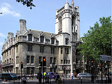 The Middlesex Guildhall at Westminster
Middlesex does not have a single established historic county town, because of the proximity and the dominance of London.[16] However, different locations having been used for different county purposes. The County Assizes for Middlesex were held at the Old Bailey in the City of London.[4] Until 1889 the High Sheriff of Middlesex was chosen by the City of London Corporation. The sessions house for the Middlesex Quarter Sessions was at Clerkenwell Green from the early eighteenth century. The quarter sessions at the former Middlesex Sessions House performed most of the administration of the county until the creation of the Middlesex County Council in 1889. New Brentford was first described as the county town in 1789, on the basis that it was the location of elections of knights for the shire (or Members of Parliament) from 1701.[15][28] In 1795, New Brentford was "considered as the county-town; but there is no town-hall or other public building".[29] Middlesex County Council, which took over the administrative duties of the Quarter Sessions in 1889, was based at the Middlesex Guildhall, in Westminster. This was in the County of London, and thus outside the council's area of jurisdiction.
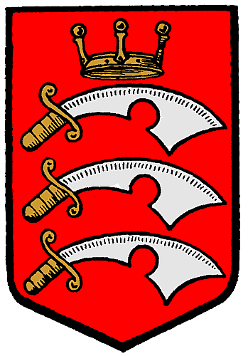
Arms of Middlesex County Council
 Coat of arms of Middlesex County Council
Coats of arms were attributed by the medieval heralds to the Kingdoms of the Anglo-Saxon Heptarchy. That assigned to the Kingdom of the Middle and East Saxons depicted three "seaxes" or short notched swords on a red background. The seaxe was a weapon carried by Anglo-Saxon warriors, and the term "Saxon" may be derived from the word.[30][31] These arms became associated with the two counties that approximated to the kingdom: Middlesex and Essex. County authorities, militia and volunteer regiments associated with both counties used the attributed arms.
In 1910 it was noted that the county councils of Essex and Middlesex and the Sheriff's Office of the County of London were all using the same arms. Middlesex County Council decided to apply for a formal grant of arms from the College of Arms, with the addition of an heraldic "difference" to the attributed arms. Colonel Otley Parry, a Justice of the Peace for Middlesex and author of a book on military badges, was asked to devise an addition to the shield. The chosen addition was a "Saxon Crown", derived from the portrait of King Athelstan on a silver penny of his reign, stated to be the earliest form of crown associated with any English sovereign. The grant of arms was made by letters patent dated 7 November 1910.[32][33][34] The blazon of the arms was:
Gules, three seaxes fessewise points to the sinister proper, pomels and hilts and in the centre chief point a Saxon crown or.
The undifferenced arms of the Kingdom were eventually granted to Essex County Council in 1932.[35] Seaxes were also used in the insignia of many of the boroughs and urban districts in the county, while the Saxon crown came to be a common heraldic charge in English civic arms.[36][37] On the creation of the Greater London Council in 1965 a Saxon crown was introduced in its coat of arms.[38] Seaxes appear in the arms of several London borough councils and of Spelthorne Borough Council, whose area was in Middlesex.[39][40]
Creation of Greater London
The population of the County of London had been in decline since its creation in 1889, and following the Second World War, the exodus continued.[8] In contrast, the population of Middlesex had seen a steady increase during that period.[41] From 1951 to 1961 the population of the inner districts of the county started to drop and growth was experienced only in eight of the suburban outer districts.[9] According to the 1961 census, Ealing, Enfield, Harrow, Hendon, Heston and Isleworth, Tottenham, Wembley, Willesden and Twickenham had all reached a population of greater than 100,000, which would normally have entitled them to seek county borough status. If granted to all these boroughs, this would have reduced the population of the administrative county of Middlesex by over half, to just shy of a million.
Following the Royal Commission on Local Government in Greater London, Parliament enacted the London Government Act 1963, which came into force on 1 April 1965.
The Act abolished the administrative counties of Middlesex and London.[42] The Administration of Justice Act 1964 abolished the Middlesex magistracy and lieutenancy. Nearly all the remainder of Middlesex became part of Greater London in 1965 and formed the new outer London boroughs of Barnet (part only), Brent, Ealing, Enfield, Haringey, Harrow, Hillingdon, Hounslow and Richmond upon Thames (part only).[43] The remaining areas were Potters Bar Urban District, which became part of Hertfordshire, while Sunbury-on-Thames Urban District and Staines Urban District became part of Surrey.[10] Following the changes, local acts of Parliament relating to Middlesex were henceforth to apply to the entirety of the nine "North West London Boroughs".[44] In 1974, the three urban districts that had been transferred to Hertfordshire and Surrey were abolished and became the districts of Hertsmere (part only) and Spelthorne respectively.[45] In 1995 the village of Poyle was transferred from Spelthorne to the Berkshire borough of Slough.[46] Additionally, since 1965 the Greater London boundary to the west and north has been subject to a significant number of small changes.[47][48]
Geography
The county lies within the London Basin[49] and the most significant feature was the River Thames, which formed the southern boundary. The River Lea and the River Colne formed natural boundaries to the east and west. In the south west of the county the Thames meandered enough to make "Middlesex bank" more descriptively accurate than "north bank"; a distinction used during the The Boat Race. In the north the boundary was mostly formed by a ridge of hills broken by Barnet valley and a long protrusion of Hertfordshire into the county.[50] The county was thickly wooded,[49] with much of it covered by the ancient Forest of Middlesex. The highest point was the High Road by Bushey Heath at 502 feet (153 m),[51] which is now one of the highest points in London.[52]
Legacy
Middlesex is used in the names of organisations based in the area such as Middlesex County Cricket Club,[53] the Middlesex Cricket Board and Middlesex University.[54] There is a Middlesex County Football Association and two teams that are now within Surrey, Staines Town and Ashford Town (Middlesex) as well as Potters Bar Town in Hertfordshire,[55] compete in the Middlesex County Cup.[56] Sir John Betjeman, a native of North London and Poet Laureate, published several poems about Middlesex and the suburban experience. Many were featured in the televised readings Metroland.[57] As part of a 2002 marketing campaign, the plant conservation charity Plantlife chose the wood anemone as the county flower. In 2003, an early day motion with two signatures noted that 16 May is the anniversary of the Battle of Albuera and in recent years has been celebrated as Middlesex Day, commemorating the valiant efforts of the Middlesex Regiment (the "Die-hards") in that battle. The idea is to recognise and celebrate the historic county.[58] On its creation in 1965, Greater London was divided into five commission areas for the administration of justice. One was named "Middlesex" and consisted of the boroughs of Barnet, Brent, Ealing, Enfield, Haringey, Harrow, Hillingdon and Hounslow.[59] This was abolished on 1 July 2003.[60]
Former postal county
Middlesex (abbreviated Middx)[61][62] is also defined as a former postal county; an element of postal addressing in routine use until 1996 and now an optional component.[11] The postal county was retained after 1965 because Royal Mail was unable to follow all the changes to county boundaries and could not adopt Greater London as a postal county.[63] However, much of inner Middlesex (Willesden, Hornsey etc.)[64] was within the London postal district, within which addresses already included "LONDON" and did not include a county. The transfer of Potters Bar to Hertfordshire was adopted by the Royal Mail, but the transfers of Staines and Sunbury to Surrey were not. The remaining postal county consisted of two unconnected areas, 6 miles (9.7 km) apart (Enfield and the rest)[61] and comprised the following post towns:
Postcode area Post towns 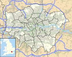


 EN (part)
ENFIELD  HA
HAEDGWARE • HARROW • NORTHWOOD • PINNER • RUISLIP • STANMORE • WEMBLEY  TW (part)
ASHFORD • BRENTFORD • FELTHAM • HAMPTON • HOUNSLOW† • ISLEWORTH • SHEPPERTON • STAINES • SUNBURY-ON-THAMES • TEDDINGTON • TWICKENHAM†  UB
UBGREENFORD • HAYES • NORTHOLT • SOUTHALL • UXBRIDGE • WEST DRAYTON † = postal county was not required
The postal county included many anomalies where the post towns it consisted of encroached on neighbouring counties, such as the village of Denham, Buckinghamshire, which is included in the post town of Uxbridge and was therefore within the postal county of Middlesex; conversely, Hampton Wick was not included in the Middlesex postal county as it was served by post towns associated with Surrey.[65] This gives Hampton Court Palace a postal address suggesting it is located in East Molesey, Surrey.[66] Wraysbury, Berkshire and Egham Hythe, Surrey are with the Staines post town and thus were also included in the Middlesex postal county.
References
- Footnotes
- ^ a b c d "Table of population, 1801-1901". A History of the County of Middlesex: Volume 22. 1911. http://www.british-history.ac.uk/report.aspx?compid=22159. Retrieved 2008-02-20.
- ^ a b c d Vision of Britain - Middlesex population (area and density). Retrieved on 2008-02-20.
- ^ Vision of Britain - 1831 Census population. Retrieved on 2008-02-20.
- ^ a b c d The Proceedings of the Old Bailey - Rural Middlesex. Retrieved on 20 February 2008.
- ^ a b c Saint, A., Politics and the people of London: the London County Council (1889-1965), (1989)
- ^ a b Barlow, I., Metropolitan Government, (1991)
- ^ a b c Wolmar, C., The Subterranean Railway, (2004)
- ^ a b Vision of Britain - County of London population. Retrieved on 2008-02-20.
- ^ a b c Vision of Britain - Census 1961: Middlesex population. Retrieved on 2008-02-20.
- ^ a b c Vision of Britain - Middlesex. Retrieved on 2008-02-20.
- ^ a b Royal Mail 2004, p. 9
- ^ Mills 2001, p. 151
- ^ "The hundred of Isleworth". A History of the County of Middlesex: Volume 3. 1962. http://www.british-history.ac.uk/report.aspx?compid=22269. Retrieved 2008-02-20.
- ^ Vision of Britain - Ossulstone hundred. Retrieved on 2008-02-20.
- ^ a b c Encyclopedia Britannica, 1911 Edition
- ^ a b c d Greater London Group (July, 1959). Memorandum of Evidence to The Royal Commission on Local Government in Greater London. London School of Economics.
- ^ Order in Council enlarging the Metropolitan Police District (SI 1840 5001)
- ^ Local Government Areas 1834 -1945, V D Lipman, Oxford, 1949
- ^ Joseph Fletcher, The Metropolis; its Boundaries, Extent, and Divisions for Local Government in Journal of the Statistical Society of London, Vol. 7, No. 2. (June 1844), pp. 103-143.
- ^ London Metropolitan Archives - A Brief Guide to the Middlesex Sessions Records, (2009). Retrieved on 26 July 2009.
- ^ Royston Lambert, Central and Local Relations in Mid-Victorian England: The Local Government Act Office, 1858-71, Victorian Studies, Vol. 6, No. 2. (Dec., 1962), pp. 121-150.
- ^ Vision of Britain - Monken Hadley. Retrieved on 2008-02-20.
- ^ Frederic Youngs, Guide to the Local Administrative Units of England, Vol.I : Southern England, London, 1979
- ^ Royston, J., Revisiting the Metro-Land Route, Harrow Times. Retrieved on 20 February 2008.
- ^ Reed, J., London Tramways, (1997)
- ^ Office of Public Sector Information - London Passenger Transport Act 1933 (as amended). Retrieved on 20 February 2008.
- ^ Royal Air Force - Battle of Britain Campaign Diary. Retrieved on 20 February 2008.
- ^ "Ealing and Brentford: Growth of Brentford". A History of the County of Middlesex: Volume 7. 1982. http://www.british-history.ac.uk/report.aspx?compid=22575&strquery=ealing%20growth. Retrieved 2008-02-20.
- ^ "Brentford". The Environs of London: volume 2: County of Middlesex. 1795. http://www.british-history.ac.uk/report.aspx?compid=45404&strquery=brentford. Retrieved 2008-02-20.
- ^ Doherty, F., The Anglo Saxon Broken Back Seax. Retrieved on 20 February 2008
- ^ Online Etymology Dictionary - Saxon. Retrieved on 20 February 2008.
- ^ Armorial bearings of Middlesex, The Times. 7 November 1910.
- ^ The Book of Public Arms, A.C. Fox-Davies, 2nd edition, London, 1915
- ^ Civic Heraldry of England and Wales, W.C. Scott-Giles, 2nd edition, London, 1953
- ^ Civic Heraldry of England and Wales - Essex County Council. Retrieved on 20 February 2008.
- ^ Civic Heraldry of England and Wales - Middlesex (obsolete). Retrieved on 20 February 2008
- ^ C W Scott-Giles, Royal and Kindred Emblems, Civic Heraldry of England and Wales, 2nd edition, London, 1953, p.11
- ^ Civic Heraldry of England and Wales - Greater London Council. Retrieved on 20 February 2008.
- ^ Civic Heraldry of England and Wales - Spelthorne Borough Council. Retrieved on 20 February 2008
- ^ Civic Heraldry of England and Wales - Greater London. Retrieved on 20 February 2008.
- ^ Vision of Britain - Middlesex population. Retrieved on 2008-02-20.
- ^ London Government Act 1963, Section 3: (1) As from 1st April 1965—
(a) no part of Greater London shall form part of any administrative county, county district or parish;
(b) the following administrative areas and their councils (and, in the case of a borough, the municipal corporation thereof) shall cease to exist, that is to say, the counties of London and Middlesex, the metropolitan boroughs, and any existing county borough, county district or parish the area of which falls wholly within Greater London;
(c) the urban district of Potters Bar shall become part of the county of Hertfordshire;
(d) the urban districts of Staines and Sunbury-on-Thames shall become part of the county of Surrey.
Section 89: (1) In this Act, except where the context otherwise requires, the following expressions have the following meanings respectively, that is to say—
'county' means an administrative county; - ^ Office of Public Sector Information - London Government Act 1963 (as amended). Retrieved on 20 February 2008.
- ^ The Local Law (North West London Boroughs) Order 1965 (S.I. 1965 No. 533)
- ^ The English Non-metropolitan Districts (Definition) Order 1972 (SI 1972/2038)
- ^ Office of Public Sector Information - Berkshire, Buckinghamshire and Surrey (County Boundaries) Order 1994. Retrieved on 20 February 2008.
- ^ Office of Public Sector Information - The Heathrow Airport (County and London Borough Boundaries) Order 1993. Retrieved on 23 February 2008.
- ^ Office of Public Sector Information - The Greater London and Surrey (County and London Borough Boundaries) (No. 4) Order 1993. Retrieved on 23 February 2008.
- ^ a b Natural England - London Basin Natural Area. Retrieved on 23 February 2008.
- ^ "The Physique of Middlesex". A History of the County of Middlesex: Volume 1. 1969. http://www.british-history.ac.uk/report.aspx?compid=22094. Retrieved 2008-02-20.
- ^ The Mountains of England and Wales - Historic County Tops. Retrieved on 20 February 2008.
- ^ The Mountains of England and Wales - London Borough Tops. Retrieved on 2 February 2008.
- ^ Middlesex County Cricket Club. Retrieved on 20 February 2008.
- ^ Middlesex University - About Us: Our History. Retrieved on 20 February 2008.
- ^ Potters Bar Town F.C. - Fixtures. Retrieved on 20 February 2008.
- ^ Mitoo - 2006–2007 Season: Middlesex County Football Association. Retrieved on 20 February 2008.
- ^ Wilson, A., Betjeman, (2006)
- ^ Randall, J., Early Day Motion 13 May 2003. Retrieved on 20 February 2008.
- ^ Administration of Justice Act 1964 (1964 C. 42)
- ^ Office of Public Sector Information - The Commission Areas (Greater London) Order 2003 (Statutory Instrument 2003 No. 640). Retrieved on 20 February 2008.
- ^ a b Geographers' A-Z Map Company 2008, p. 1
- ^ Royal Mail - PAF Digest Issue 6.0. Retrieved 20 February 2008.
- ^ "G.P.O. To Keep Old Names. London Changes Too Costly.". The Times. April 12, 1966.
- ^ HMSO, Names of Street and Places in the London Postal area, (1930). Retrieved on 20 February 2008.
- ^ Paul Waugh (29 May 2003). "Property boom fuels calls to reform 'postcode lottery'". The Independent. http://www.independent.co.uk/life-style/house-and-home/property/property-boom-fuels-calls-to-reform-postcode-lottery-591325.html. Retrieved 2009-11-02.
- ^ "Hampton Court: How to find us". Historic Royal Palaces. http://www.hrp.org.uk/HamptonCourtPalace/planyourvisit/gettingthere.aspx. Retrieved 2009-11-02.
- Bibliography
- Geographers' A-Z Map Company (2008), London Postcode and Administrative Boundaries (6 ed.), Geographers' A-Z Map Company, ISBN 9781843485926
- Mills, A.D. (2001), Dictionary of London Place Names, Oxford, ISBN 0192801066
- Page, William (Edr.) (1911), A History of the County of Middlesex: Volume 2, Victoria County History, British History Online, http://www.british-history.ac.uk/report.aspx?compid=22150
- Royal Mail (2004), Address Management Guide (4 ed.), Royal Mail Group
External links
- Victoria County History of Middlesex
- Historic boundary as layer for Google Earth
- Maps of Middlesex subdivisions: Edmonton, Elthorne, Gore, Isleworth and Spelthorne
Neighbouring counties (1889-1965) 
Buckinghamshire Hertfordshire Herts/Essex Berkshire 
Essex  Middlesex

Surrey Surrey London Historic subdivisions of Middlesex Edmonton · Elthorne · Gore · Isleworth · Ossulstone · Spelthorne
City of London · Finsbury · Holborn · Kensington · Tower Hamlets · City and Liberty of Westminster
Governance of Greater London Regional London boroughs - Barking and Dagenham
- Barnet
- Bexley
- Brent
- Bromley
- Camden
- Croydon
- Ealing
- Enfield
- Greenwich
- Hackney
- Hammersmith and Fulham
- Haringey
- Harrow
- Havering
- Hillingdon
- Hounslow
- Islington
- Kensington and Chelsea
- Kingston upon Thames
- Lambeth
- Lewisham
- Merton
- Newham
- Redbridge
- Richmond upon Thames
- Southwark
- Sutton
- Tower Hamlets
- Waltham Forest
- Wandsworth
- Westminster
Ceremonial Historical - Metropolitan Board of Works (MBW) 1855–1889
- London County Council (LCC) 1889–1965
- Greater London Council (GLC) 1965–1986
- Leaders
Local government districts abolished or transferred by the London Government Act 1963 London · CC Battersea · Bermondsey · Bethnal Green · Camberwell · Chelsea · Deptford · Finsbury · Fulham · Greenwich · Hackney · Hammersmith · Hampstead · Holborn · Islington · Kensington · Lambeth · Lewisham · Paddington · Poplar · Shoreditch · Southwark · St. Marylebone · St. Pancras · Stepney · Stoke Newington · Wandsworth · Westminster · Woolwich
Constituent parts of Greater LondonEssex Barking · Chigwell (part) · Chingford · Dagenham · East Ham · Hornchurch · Ilford · Leyton · Romford · Walthamstow · Wanstead and Woodford · West Ham
Hertfordshire Middlesex · CC Acton · Brentford and Chiswick · Ealing · Edmonton · Enfield · Feltham · Finchley · Friern Barnet · Harrow · Hayes and Harlington · Hendon · Heston and Isleworth · Hornsey · Ruislip-Northwood · Southall · Southgate · Tottenham · Twickenham · Uxbridge · Wembley · Willesden · Wood Green · Yiewsley and West Drayton
Kent Surrey Transfers Categories:- Middlesex
- Counties of England disestablished in 1965
- Counties of England established in antiquity


Wikimedia Foundation. 2010.