- Essex
-
For other uses, see Essex (disambiguation).
Essex 
Motto of County Council: Essex Works.
For a better quality of life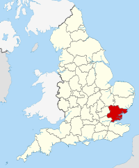
Geography Status Ceremonial & (smaller) Non-metropolitan county Origin Historic Region East of England Area
- Total
- Admin. council
- Admin. areaRanked 11th
3,670 km2 (1,420 sq mi)
Ranked 11th
3,465 km2 (1,338 sq mi)Admin HQ Chelmsford ISO 3166-2 GB-ESS ONS code 22 NUTS 3 UKH33 Demography Population
- Total (2010 est.)
- Density
- Admin. council
- Admin. pop.Ranked 6th
1,737,900
474 /km2 (1,230 /sq mi)
Ranked 2nd
1,412,900Ethnicity 96.8% White
1.2% S. AsianPolitics 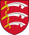
Essex County Council
http://www.essex.gov.uk/Executive Conservative Members of Parliament - David Amess (C)
- John Baron (C)
- Simon Burns (C)
- Douglas Carswell (C)
- Jackie Doyle-Price (C)
- James Duddridge (C)
- Mark Francois (C)
- Robert Halfon (C)
- Rebecca Harris (C)
- Alan Haselhurst (C)
- Bernard Jenkin (C)
- Eleanor Laing (C)
- Stephen Metcalfe (C)
- Brooks Newmark (C)
- Priti Patel (C)
- Eric Pickles (C)
- Bob Russell (LD)
- John Whittingdale (C)
Districts 
- Harlow
- Epping Forest
- Brentwood
- Basildon
- Castle Point
- Rochford
- Maldon
- Chelmsford
- Uttlesford
- Braintree
- Colchester
- Tendring
- Thurrock (Unitary)
- Southend-on-Sea (Unitary)
Essex (
 /ˈɛsɨks/) is a ceremonial and non-metropolitan county in the East region of England, and one of the home counties. It is located to the northeast of Greater London and is one of the most populous counties in England. It borders with Cambridgeshire and Suffolk to the north, Hertfordshire to the west, Kent to the South and London to the south west. Essex County Council is the principal local authority for much of the county, sharing functions with twelve district councils. The county town is Chelmsford. The southern Essex boroughs of Thurrock and Southend-on-Sea are governed separately as unitary authorities. It was established in antiquity and formed the eastern portion of the Kingdom of Essex. Sections of the county closer to London are part of the Metropolitan Green Belt, which prohibits development. It is the location of the regionally significant Lakeside Shopping Centre and London Stansted Airport; and the new towns of Basildon and Harlow.
Contents
History
Main article: History of EssexThe name Essex originates in the Anglo-Saxon period of the Early Middle Ages and has its root in the Old English Ēastseaxe (i.e. the "East Saxons"), the eastern kingdom of the Saxons. Originally (in 527 AD) it occupied territory to the north of the River Thames, incorporating all of what later became Middlesex and most of what later became Hertfordshire, though its territory was later restricted to lands east of the River Lea.[1] Colchester in the north east of the county is Britain's oldest recorded town, dating back to before the Roman conquest, when it was known as Camulodunum and was sufficiently well-developed to have its own mint. Subsequently the Kingdom of Essex was subsumed into the Kingdom of England and Essex eventually became a county.
Essex County Council was formed in 1889. However the County Borough of West Ham and, from 1915, the County Borough of East Ham formed part of the county but were not under county council control.[2] A few Essex parishes were transferred to other counties. In earlier times, parts were transferred to Hertfordshire near Bishops Stortford and Sawbridgeworth. At the time of the main changes around the turn of the 19th/20th centuries; parts of Helions Bumpstead and Sturmer were transferred to Haverhill Suffolk, Kedington and Ballingdon-with-Brundon both went to Suffolk, and Great Chishill, Little Chishill and Heydon to Cambridgeshire. Southend-on-Sea also formed a county borough from 1914 to 1974.[3] Later still, part of Hadstock was transferred to Linton, Cambridgeshire, part of Ashdon to Bartlow, Cambridgeshire, part of Chrishall to Cambridgeshire, part of Great Horkesley to Nayland in Suffolk, and several other small territories were transferred to all of those three counties.
The boundary with Greater London was established in 1965 when East Ham and West Ham county boroughs and the Barking, Chingford, Dagenham, Hornchurch, Ilford, Leyton, Romford, Walthamstow and Wanstead and Woodford districts[2] were transferred to form the London boroughs of Barking, Havering, Newham, Redbridge and Waltham Forest. Essex became part of the East of England Government Office Region in 1994 and was statistically counted as part of that region from 1999, having previously been part of the South East England region. In 1998, the districts of Southend-on-Sea and Thurrock were separated from the shire county of Essex becoming unitary districts.
The county of Essex is divided into a number of local government districts. They are Harlow, Epping Forest, Brentwood, Basildon, Castle Point, Rochford, Maldon, Chelmsford, Uttlesford, Braintree, Colchester, Tendring, Thurrock, and Southend-on-Sea.[4] The last two boroughs are unitary authorities which form part of the county but are not administered by the county council.[5] Essex Police also covers the two unitary authorities.[6]
The county council meets at the County Hall, in Chelmsford. Before 1938, it regularly met in London near Moorgate, which had been more convenient than any place in the county. It currently has 75 elected councillors. Before 1965, the number of councillors reached over 100. The County Hall, which dates largely from the mid-1930s, and is decorated with fine artworks of that period, mostly the gift of the family who owned the textile firm, Courtaulds, was made a listed building in 2007.
Geography
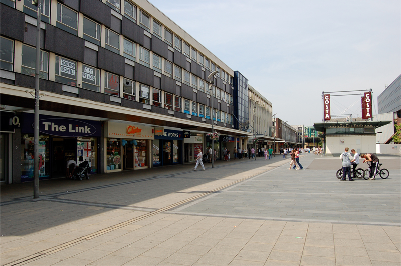
See also: List of places in Essex The plaza of the new town of Basildon
The highest point of the county of Essex is Chrishall Common near the village of Langley, close to the Hertfordshire border, which reaches 482 feet (147 m). The ceremonial county of Essex is bounded to the south by the River Thames and its estuary (a boundary shared with Kent); to the southwest by Greater London; to the west by Hertfordshire with the boundary largely defined by the River Lea and the Stort; to the northwest by Cambridgeshire; to the north by Suffolk, a boundary mainly defined by the River Stour; and to the east by the North Sea.
The pattern of settlement in the county is diverse. The Metropolitan Green Belt has effectively prevented the further sprawl of London into the county, although it contains the new towns of Basildon and Harlow, originally developed to resettle Londoners following the destruction of London housing in World War II but since much expanded. Epping Forest also acts as a protected barrier to the further spread of London. Because of its proximity to London and the economic magnetism which that city exerts, many of Essex's settlements, particularly those on or within driving distance of railway stations, function as dormitory towns or villages where London workers raise their families.
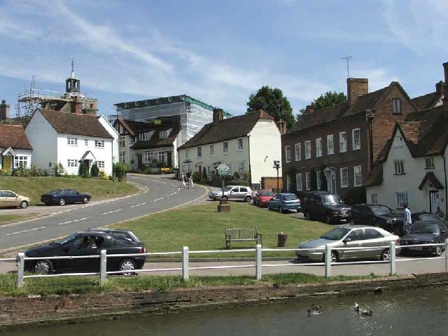
 The village of Finchingfield in north Essex
 Skyline of Southend-on-Sea
Part of the south east of the county, already containing the major population centres of Basildon, Southend and Thurrock, is within the Thames Gateway and designated for further development. Parts of the south west of the county such as Buckhurst Hill and Chigwell are contiguous with Greater London and are included in the Greater London Urban Area. A small part of the south west of the county (Sewardstone), is the only settlement outside Greater London to be covered by a postcode district of the London post town (E4 ). To the north of the green belt, with the exception of major towns such as Colchester and Chelmsford, the county is rural, with many small towns, villages and hamlets largely built in the traditional materials of timber and brick, with clay tile or thatched roofs.
Economy
Industry is largely limited to the south of the county, with the majority of the land elsewhere being given over to agriculture. Harlow is a centre for electronics, science and pharmaceutical companies, while Chelmsford is the home of Marconi (now called telent plc and owned by Ericsson of Sweden since 2005), Basildon home to New Holland Agriculture's European headquarters and Brentwood home to the Ford Motor Company's European HQ. Loughton is home to a production facility for British and foreign banknotes. Chelmsford has been an important location for electronics companies since the industry was born, is also the location for a number of insurance and financial services organisations, and is the home of the soft drinks producer Britvic. Other businesses in the county are dominated by light engineering and the service sector. Colchester is a garrison town, and the local economy is helped by the Army's personnel living there.
Parts of Eastern Essex suffer from high levels of deprivation, with one of the most highly deprived wards being in Clacton.[7] In the Indices of deprivation 2007, Jaywick was identified as the most deprived Lower Super Output Area in Southern England.[8] Unemployment was estimated at 44% and many homes were found to severely lack basic amenities. The Brooklands and Grasslands area of Jaywick were found to be the third most deprived area in England; only Liverpool and Manchester rated higher. In contrast, however, South West Essex is a mostly affluent part of Eastern England, forming part of the London commuter belt. South West Essex has a large middle class and the area is widely known for its Independent schools. In 2008, The Daily Telegraph found Brentwood and Ingatestone to be the 19th and 14th richest towns in the UK respectively.[9]
Transport
 London Stansted Airport, in the north west of the county
The main airport in Essex is London Stansted Airport, serving destinations in Europe and Asia. The Lib-Con coalition government formed in May 2010 has agreed to resist an additional runway at Stansted, so curtailing the operator's ambitions for expansion. London Southend Airport, once one of Britain's busiest airports, is undergoing rebuilding,will offer schedule flights to Ireland and offers limited passenger flights each summer to the Channel Islands; a new railway station is nearly complete on the airport's eastern boundary and a runway extension will then be built in a south-westerly direction. There are several smaller airfields, some of which owe their origins to military bases built during World War I or World War II. These are popular for pleasure flights or flying lessons; examples include Clacton Airfield, Earls Colne Airfield, and Stapleford Aerodrome.
The Port of Tilbury is one of Britain's three major ports, while the port of Harwich links the county to the Hook of Holland and Esbjerg (a service to Cuxhaven Having discontinued in December 2005). Plans have been approved to build the UK's largest container terminal at Shell Haven in Thurrock and although opposed by the local authority and environmental and wildlife organisations now seem increasingly likely to be developed.[10][11][12]
 Queen Elizabeth II Bridge spanning the Thames from West Thurrock, Essex, to Dartford, Kent
Despite the existence of the Dartford Road Crossing to Dartford, Kent, across the Thames River, a ferry for pedestrians to Gravesend, Kent, still operates from Tilbury during limited daily hours, and ferries for pedestrians operate across some of Essex's rivers and estuaries during spring and summer. The M25 motorway and M11 motorway both cross the county in the extreme south and west, linking those parts of the county with Kent, Hertfordshire and Cambridge. The A127 and A13 trunk roads are important radial routes connecting London and the M25 to the south of Essex. The A12 runs across the county from the south west to the north east and not only carries traffic within Essex but also traffic between London and Suffolk, east Norfolk and the ports of Felixstowe and Harwich.
There is an extensive public transport network. The main railway routes in Essex include two lines from the City of London to Southend-on-Sea, operated by c2c from Fenchurch Street railway station (including a route via Tilbury) and by National Express East Anglia from Liverpool Street station; the Great Eastern Main Line from Liverpool Street connecting to Harwich and onwards into Suffolk and Norfolk; and the West Anglia Main Line from Liverpool Street linking to Stansted and onwards into Cambridgeshire. The Epping Forest district is served by the London Underground Central Line. The routes operated by National Express East Anglia (formerly known as "One") and c2c, are both owned by National Express. There are also a number of branch lines including the Sunshine Coast Line linking Colchester to the seaside resorts of Clacton-on-Sea and Walton-on-the-Naze via the picturesque towns of Wivenhoe and Great Bentley. The Crouch Valley Line, another branch line, links Wickford to a number of riverside communities via South Woodham Ferrers and Burnham-on-Crouch to Southminster.
South Essex Rapid Transit is a proposed public transport scheme which would provide a fast, reliable public transport service in, and between, Thurrock, Basildon and Southend.[13]
Education
Further information: List of schools in Essex, List of schools in Southend-on-Sea, List of schools in Thurrock, and List of primary schools in EssexEducation in Essex is substantially provided by three authorities being Essex County Council and the two unitary authorities, Southend-on-Sea and Thurrock. In all there are some 90 state secondary schools provided by these authorities, the majority of which are comprehensive, although one in Uttlesford, two in Chelmsford, two in Colchester and four in Southend-on-Sea are selective. There are also various Independent Schools providing education in Essex.[14][15]
The University of Essex, which was established in 1963, is located just outside Colchester, with two further campuses in Loughton and Southend-on-Sea. University Campus Suffolk, with a main campus in Ipswich and five centres in the counties of Norfolk and Suffolk, is a joint venture between University of Essex and University of East Anglia. Anglia Ruskin University was awarded university status in 1992 and has campuses in Chelmsford and Cambridge.
Culture
 Depiction of the first king of the East Saxons, Æscwine, his shield showing the three seaxes emblem attributed to him (from John Speed's 1611 Saxon Heptarchy).
The County's coat of arms comprises three Saxon seax knives (although looking rather more like scimitars) arranged on a red background; the three-seax device is also used as the official logo of Essex County Council having been granted as such in 1932.[16] The emblem was attributed to Anglo-Saxon Essex in Early Modern historiography. The earliest reference the arms of the East Saxon kings was by Richard Verstegan, the author of A Restitution of Decayed Intelligence (Antwerp, 1605), claiming that "Erkenwyne king of the East-Saxons did beare for his armes, three [seaxes] argent, in a field gules". There is no earlier evidence substantiating Verstegan's claim, which is an anachronism for the Anglo-Saxon period seeing that heraldry only evolved in the 12th century, well after the Norman conquest. John Speed in his Historie of Great Britaine (1611) follows Verstegan in his descriptions of the arms of Erkenwyne, but he qualifies the statement by adding "as some or our heralds have emblazed".[16]

Essex is also home to the Dunmow Flitch Trials, a traditional ceremony that takes place every four years and consists of a test of a married couple's devotion to one another. A common claim of the origin of the Dunmow Flitch dates back to 1104 and the Augustinian Priory of Little Dunmow, founded by Lady Juga Baynard. Lord of the Manor Reginald Fitzwalter and his wife dressed themselves as humble folk and begged blessing of the Prior a year and a day after marriage. The Prior, impressed by their devotion bestowed upon them a Flitch of Bacon. Upon revealing his true identity, Fitzwalter gave his land to the Priory on the condition a Flitch should be awarded to any couple who could claim they were similarly devoted. By the 14th century, the Dunmow Flitch Trials appear to have achieved a significant reputation outside the local area. The author William Langland, who lived on the Welsh borders, mentions it in his 1362 book The Vision of Piers Plowman in a manner that implies general knowledge of the custom among his readers.[17]
Landmarks
Over 14,000 buildings have listed status in the county, and around 1000 of those are recognised as of Grade I or II* importance.[18] The buildings range from the 7th century Saxon church of St Peter-on-the-Wall, to the Royal Corinthian Yacht Club which was the United Kingdom's entry in the "International Exhibition of Modern Architecture" held at the Museum of Modern Art in New York City in 1932.
-

The church of St Peter-on-the-Wall, Bradwell-on-Sea.
-
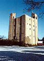
The Grade I listed Hedingham Castle.
-

Thaxted Guildhall dating from around 1450.
-
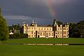
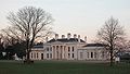
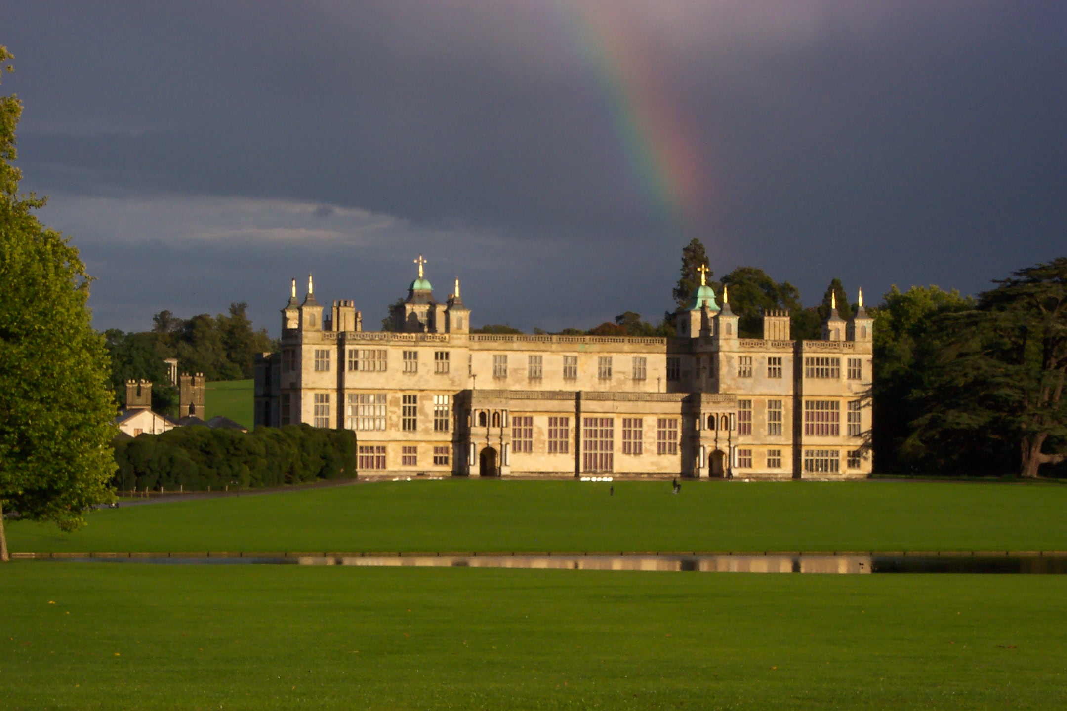
The 17th century Audley End House in Saffron Walden.
-

The Royal Corinthian Yacht Club, Burnham-on-Crouch.
-
Hylands House
Places of interest
Key 
Abbey/Priory/Cathedral 
Accessible open space 
Amusement/Theme Park 
Castle 
Country Park 
English Heritage 
Forestry Commission 
Heritage railway 
Historic House 

Museum (free/not free) 
National Trust 
Zoo - Abberton Reservoir
- Arena Essex Raceway
- Ashingdon (The site of the Battle of Ashingdon in 1016)
- Audley End

- Clacton-On-Sea
- Colchester Castle
 [19]
[19] - Chelmsford Cathedral
- Colchester Zoo
- Colne Valley Railway
- East Anglian Railway Museum
- Epping Forest
- Frinton-on-Sea
- Great Bentley Home to the Largest Village green in England
- Harlow New Town
- Hedingham Castle
- Ingatestone Hall
- Kelvedon Hatch (Secret Nuclear Bunker)
- Loughton
- Maldon Historic market town site of the Battle of Maldon
- Mangapps Railway Museum (Burnham-on-Crouch)
- Marsh Farm Country Park
- Mersea Island
- Mistley towers
- Mountfitchet Castle
- North Weald Airfield
- Orsett Hall
- St Peter-on-the-Wall
- Saffron Walden
- Southend Pier
- Thaxted
- University of Essex (Wivenhoe Park, Colchester)
- Waltham Abbey
Notable persons
- See Category:People from Essex.
Sister counties and regions
 Jiangsu, China
 Picardy, France
 Thuringia, Germany
 Henrico County, Virginia
 Accra, Ghana
See also
- The Earl of Essex
- Q Camp: WWII camp in Essex
- List of civil parishes in England
- Lord Lieutenant of Essex
- High Sheriff of Essex
Notes and references
- ^ Vision of Britain – Essex ancient county boundaries map
- ^ a b Vision of Britain – Essex admin county (historic map)
- ^ Vision of Britain – Southend-on-Sea MB/CB
- ^ Essex County Council – District or Borough Councils
- ^ OPSI – The Essex (Boroughs of Colchester, Southend-on-Sea and Thurrock and District of Tendring) (Structural, Boundary and Electoral Changes) Order 1996
- ^ OPSI – The Essex (Police Area and Authority) Order 1997
- ^ http://www.chelmsford.anglican.org/did-you-know-deprivation-in-chelmsford-diocese.html
- ^ http://www.clactonandfrintongazette.co.uk/news/colchester/1901353.Jaywick__Village____third_most_deprived_area_in_UK___/
- ^ "Britain's richest towns: 20 – 11". The Daily Telegraph (London). 18 April 2008. http://www.telegraph.co.uk/property/3361038/Britains-richest-towns-20-11.html.
- ^ Portswatch: Current Port Proposals: London Gateway (Shell Haven). Retrieved 15 April 2009.
- ^ Thurrock Council. (2003-02-26). Shell Haven public inquiry opens. Retrieved 15 April 2009.
- ^ Dredging News Online. (2008-05-18). Harbour Development, Shell Haven, UK. Retrieved 15 April 2009.
- ^ "FAQ". http://www.sert.org.uk/faqs.asp.
- ^ Essex County Council. (2006). Secondary School Information. Retrieved 15 April 2009.
- ^ Independent Schools Directory. (2009). Independent Schools in Essex. Retrieved 15 April 2009.
- ^ a b Robert Young. (2009). Civic Heraldry of England and Wales. Essex. Retrieved 16 April 2009.
- ^ Dunmow Flitch Trials website. Retrieved 12 April 2010.
- ^ Bettley, James. (2008). Essex Explored: Essex Architecture. Essex County Council. Retrieved 15 April 2009.
- ^ "Colchester Castle Museum-Index". Colchestermuseums.org.uk. http://www.colchestermuseums.org.uk/castle/castle_index.html. Retrieved 23 April 2010.
External links
- Essex at the Open Directory Project
- Visit Essex
- Essex County Council
- Seax – Essex Archives Online
- Digital Images of Essex
- Essex Registration Service
- Dunmow Flitch Trials
- Essex Gigs 2010
- BBC Essex
- British History Online
- Essex Churches
- Essex Community Forums
Neighbouring counties 
Cambridgeshire Cambridgeshire / Suffolk Suffolk Hertfordshire 
North Sea  Essex
Essex 

Greater London Kent Thames Estuary Ceremonial county of Essex Unitary authorities Boroughs or districts Basildon • Braintree • Brentwood • Castle Point • Chelmsford • Colchester • Epping Forest • Harlow • Maldon • Rochford • Tendring • UttlesfordMajor settlements Basildon • Billericay • Braintree • Brentwood • Brightlingsea • Buckhurst Hill • Burnham-on-Crouch • Canvey Island • Chelmsford • Chigwell • Chipping Ongar • Clacton-on-Sea • Coggeshall • Colchester • Corringham • Dovercourt • Eastwood • Epping • Frinton-on-Sea • Grays • Great Dunmow • Hadleigh • Halstead • Harlow • Harwich • Holland-on-Sea • Ingatestone • Laindon • Langdon Hills • Leigh-on-Sea • Loughton • Maldon • Manningtree • Parkeston • Pitsea • Rayleigh • Rochford • Saffron Walden • Shoeburyness • South Benfleet • Southend-on-Sea • South Woodham Ferrers • Southminster • Stanford-le-Hope • Thaxted • Tilbury • Waltham Abbey • Walton-on-the-Naze • West Mersea • West Thurrock • Wickford • Witham • Wivenhoe
See also: List of civil parishes in EssexRivers Blackwater • Brain • Cam • Can • Chelmer • Ching • Cobbins Brook • Colne • Crouch • River Lee Flood Relief Channel • Mardyke • Prittle Brook • Roach • Roding • Stort • Stour • Stour Brook • Ter • ThamesTopics Categories:- Essex
- Non-metropolitan counties
- NUTS 2 statistical regions of the United Kingdom


Wikimedia Foundation. 2010.