- Municipal Borough of Ilford
-
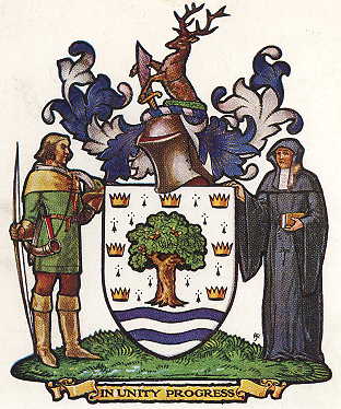
Ilford Motto: In unity progress 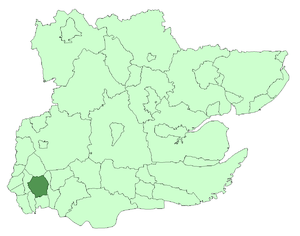
Ilford within Essex in 1961Geography Status Civil parish (1888—1965)
Local board (1890—1894)
Urban district (1894—1926)
Municipal borough (1926—1965)1911 area 8,496 acres (34.38 km2)[1] 1931 area 8,493 acres (34.37 km2)[1] 1961 area 8,404 acres (34.01 km2)[1] HQ Ilford History Origin Chadwell and Ilford wards of Barking parish Created 1888 Abolished 1965 Succeeded by London Borough of Redbridge Demography 1911 population
- 1911 density78,188[1]
9.2/acre1931 population
- 1931 density131,061[1]
15.4/acre1961 population
- 1961 density178,024[1]
21.2/acre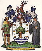
Coat of arms of the borough councilIlford was a civil parish and local government district in south west Essex, England from 1888 to 1965, covering the town Ilford. The district saw a considerable rise in population throughout its life,[1] caused by the expansion of the built-up area of London, and became one of the most populous districts of its type in England. The district now corresponds to the greater part of the London Borough of Redbridge in Greater London.
Contents
Formation
Ilford had historically formed a ward in Barking parish, but in 1888 with the Chadwell ward it became a separate civil parish.[2] The area had formed part of the Metropolitan Police District since 1840. A local board was formed for Ilford in 1890 and in 1894 it became an urban district under the Local Government Act 1894.[3]
District and borough
The urban district council was originally based in rooms above a shop in Cranbrook Road, meeting in a rented schoolroom in Ilford Hall from 1898. The building of Ilford Town Hall began in 1901[4], completed at a cost of about £30,000. This was designed by B. Woollard in an ornate Renaissance style; it was enlarged in 1927 and 1933[2].
Successive acts provided the council with increased powers and they used these to embark on an expansion of public services, providing sewerage, public baths, an isolation hospital, a fire station, an electricity and tramway undertaking,[5] and several public parks – including Valentine's Park, opened as Central Park in 1898. In 1904, the council also took over the responsibilities of the school board.[2]
In 1926, the urban district was incorporated as a municipal borough.[2] The borough ran its own tram services until they became the responsibility of the London Passenger Transport Board in 1933.[5]
A move was mooted in 1929 to combine Ilford with Barking and Dagenham (the three districts to contain parts of the Becontree estate),[6] but it was not acted upon.
On five occasions Ilford Corporation unsuccessfully promoted private bills in parliament to attain county borough status and become independent of Essex County Council. The final attempt was in 1954, when the borough had a population of approximately 184,000,[7] larger than neighbouring East Ham and the second largest non-county borough in England.[2]
In 1914, the parish of Barking was transferred from the Diocese of St Albans to a new Diocese of Chelmsford, reflecting the increase in population to the east of London.
Population
The population was affected by the building of the Becontree estate from 1921, which was partly in the borough. The Central Line service of the London Underground began in 1947[8] and the population peaked in 1951.
Year[1] 1891 1901 1911 1921 1931 1951 1961 Population 10,913 41,234 78,188 85,194 131,061 184,706 178,024 Abolition
The borough was considered to form part of the Greater London Conurbation, as defined by the Registrar General. In 1965, under the London Government Act 1963, the municipal borough was abolished and its former area transferred to Greater London to be combined with that of the Municipal Borough of Wanstead and Woodford and parts of the Municipal Borough of Dagenham and Chigwell Urban District to form the London Borough of Redbridge.[9]
References
- ^ a b c d e f g h Vision of Britain - Ilford population (area and density). Retrieved on 11 February 2008.
- ^ a b c d e 'The borough of Ilford', A History of the County of Essex: Volume 5 (1966), pp. 249-66 accessed: 05 May 2007
- ^ Vision of Britain - Ilford UD/MB (historic map)
- ^ A brief history of Redbridge, London Borough of Redbridge website
- ^ a b Reed, J., London Tramways, (1997)
- ^ 'The borough of Barking', A History of the County of Essex: Volume 5 (1966), pp. 235-48 accessed 05 May 2007.
- ^ Fifth attempt to raise status, The Times, June 9, 1954
- ^ Rose, D., The London Underground: A diagrammatic history, (1999)
- ^ Schedule I to the London Government Act 1963
External links
Local government districts abolished or transferred by the London Government Act 1963 London · CC Battersea · Bermondsey · Bethnal Green · Camberwell · Chelsea · Deptford · Finsbury · Fulham · Greenwich · Hackney · Hammersmith · Hampstead · Holborn · Islington · Kensington · Lambeth · Lewisham · Paddington · Poplar · Shoreditch · Southwark · St. Marylebone · St. Pancras · Stepney · Stoke Newington · Wandsworth · Westminster · Woolwich
Constituent parts of Greater LondonEssex Barking · Chigwell (part) · Chingford · Dagenham · East Ham · Hornchurch · Ilford · Leyton · Romford · Walthamstow · Wanstead and Woodford · West Ham
Hertfordshire Middlesex · CC Acton · Brentford and Chiswick · Ealing · Edmonton · Enfield · Feltham · Finchley · Friern Barnet · Harrow · Hayes and Harlington · Hendon · Heston and Isleworth · Hornsey · Ruislip-Northwood · Southall · Southgate · Tottenham · Twickenham · Uxbridge · Wembley · Willesden · Wood Green · Yiewsley and West Drayton
Kent Surrey Transfers Categories:- Districts of England created by the Local Government Act 1894
- Districts abolished by the London Government Act 1963
- History of Redbridge
- History of local government in London (1889–1965)
- Municipal boroughs of England


Wikimedia Foundation. 2010.