- County of London
-
London 
County of London shown within EnglandGeography Status Administrative and (smaller) ceremonial county 1911 area 74,816 acres (302.77 km2) 1961 area 74,903 acres (303.12 km2) HQ County Hall, Lambeth History Origin The Metropolis Created 1889 Abolished 1965 Succeeded by Greater London Demography 1911 population
- 1911 density4,521,685
60/acre1961 population
- 1961 density3,200,484
42/acrePolitics Governance London County Council 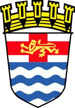
Arms of London County CouncilSubdivisions Type Metropolitan boroughs (from 1900) 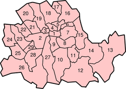
Boroughs numbered 2-29 (1 is the City)The County of London was a county of England from 1889 to 1965, corresponding to the area known today as Inner London. It was created as part of the general introduction of elected county government in England, by way of the Local Government Act 1888. The Act created an administrative County of London, which included within its territory the City of London. However, the City of London and the County of London formed separate counties for "non-administrative" purposes.[1] The local authority for the county was the London County Council (LCC), which initially performed only a limited range of functions, but gained further powers during its 76-year existence. The LCC provided very few services within the City of London, where the ancient Corporation monopolised local governance, as it still does.[1] In 1900 the lower-tier civil parishes and district boards were replaced with 28 new metropolitan boroughs. The territory of the county was 74,903 acres (303.12 km2) in 1961. During its existence there was a long-term decline in population as more residents moved into the outer suburbs; there were periodic reviews of the local government structures in the greater London area and several failed attempts to expand the boundaries of the county. In 1965, the London Government Act 1963 replaced the county with the much larger Greater London administrative area.
Contents
Geography
The county occupied an area of just under 75,000 acres (30,351 ha) and lay within the London Basin.[2] It was divided into two parts (north and south) by the River Thames, which was the most significant geographic feature. It bordered Essex to the north east, Kent to the south east, Surrey the south west and Middlesex to the north. The highest point was Hampstead Heath in the north of the county at 440 feet (134 m), which is one of the highest points in London. In 1900 a number of boundary anomalies were abolished. These included the loss of the Alexandra Park exclave to Middlesex, gaining South Hornsey in return, and the transfer of Penge to Kent.
History
Creation of the county
The local government arrangements in London had last been reformed in 1855. This reform created an indirectly elected Metropolitan Board of Works which initially provided basic infrastructure services for the metropolitan area.[3] Over time the board gained more functions and became the de-facto local authority and provider of new services for the London area. The board operated in those parts of the counties of Middlesex, Surrey and Kent that had been designated by the General Register Office as "the Metropolis" for the purposes of the Bills of Mortality.[3] This area had been administered separately from the City of London, which came under the control of the Corporation of London.
There had been several attempts during the 19th century to reform London government, either by expanding the City of London to cover the whole of the metropolitan area; by creating a new county of London;[4] or by creating ten municipal corporations matching the parliamentary boroughs of the metropolis.[5] These had all been defeated in Parliament, in part because of the agency power of the City Corporation.[6] Ultimately, the Local Government Act 1888 and the introduction of county councils in England provided the mechanism for creating a territory and authority encompassing the expanded London area. For expediency, the area of the metropolitan board was chosen for the new county, and no attempt was made to select new boundaries.[1] This area had been out of line with the expansion of London even in 1855.[3] For example, it anomalously omitted built-up and expanding areas such as West Ham, but included some sparsely populated areas on the metropolitan fringe.[3]
The City of London and the County of London each formed counties for "non-administrative" purposes, with a separate Lord Lieutenant and High Sheriff for the county of London.[1] However, the administrative county, which corresponded to the area of control of the county council, also included the City of London. In practice, the county council had very little authority over the ancient City, with some powers over drainage, roads, fire brigade, embankment of the river and flood prevention.[1] In common with the rest of the country, the 1888 Act provided no reform of lower-tier authorities and the county was, initially at least, locally governed by a series of parish vestries and district boards.
County council
Main article: London County CouncilThe local authority for the county was the London County Council (LCC). Initially, the LCC provided the services it had inherited from the Metropolitan Board of Works.[1] However, it eventually absorbed functions from ad-hoc agencies such the London School Board and Metropolitan Asylums Board. The council was initially based in Spring Gardens, but moved to a purpose-built County Hall in the 1930s. The housing policy of the council included provision of large housing estates outside the boundaries of the county, such as that at Becontree.[7]
Local government
In 1900, eleven years after its foundation, the London Government Act divided the County of London into 28 metropolitan boroughs. These replaced the ancient parish vestries and district boards as the second tier of local government.
County of London boroughs numbered in the information box on the right side:
- City of London (not a metropolitan borough)
Decline in population
The county had a declining population throughout its life. In 1901 the population was 4.5 million and by 1961 it had fallen to 3.2 million. Following the 1931 census more of the population of "Greater London" (defined at the time as the Metropolitan Police District and City of London) lived outside the county than in it.[8] The following table illustrates the approximate population according to the census at various intervals:[9]
Year Central Area† Inner Ring‡ Second Ring§ County of London
TotalOuter Ring# of
Greater London1881 1,743,000 1,008,000 1,093,000 3,844,000 950,000[10] 1901 1,623,000 1,201,000 1,601,000 4,425,000 1,422,000[11] 1921 1,364,000 1,186,000 1,933,000 4,483,000 2,993,000[12] 1931 1,260,000 1,163,000 1,976,000 4,399,000 3,807,000[8] 1951 738,000 927,000 1,683,000 3,348,000 4,998,000[13] †The City of London and the Metropolitan Boroughs of Bermondsey, Bethnal Green, Finsbury, Holborn, St Marylebone, St Pancras, Shoreditch, Southwark, Stepney and Westminster.
‡The Metropolitan Boroughs of Battersea, Chelsea, Islington, Kensington, Lambeth and Paddington.
§The Metropolitan Boroughs of Camberwell, Deptford, Fulham, Greenwich, Hackney, Hammersmith, Hampstead, Lewisham, Poplar, Stoke Newington, Wandsworth and Woolwich.
#Defined as the area of the Metropolitan Police district outside the County of London.
Abolition
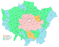
 County of London superimposed upon Greater London
The county was abolished in 1965 and was replaced by the much larger Greater London, which took in nearly all of Middlesex, along with areas previously in Surrey, Kent, Essex and Hertfordshire.[14] The area that had formed the county was henceforth known as Inner London and an Inner London Education Authority operated in the area until 1990. The 28 metropolitan boroughs were merged to form 12 new Inner London boroughs.
See also
- List of civil parishes in the County of London in 1891
References
- ^ a b c d e f Robson 1939, pp. 80–92.
- ^ Natural England - London Basin Natural Area. Retrieved on 22 July 2009.
- ^ a b c d Robson 1939, pp. 54–61.
- ^ County of London Bill, 1870
- ^ Municipal Boroughs (Metropolis) Bill, 1870
- ^ Robson 1939, pp. 71-79.
- ^ Robson 1939, pp. 168-169.
- ^ a b "London census - Decline in County Population". The Times (London): p. 7. 27 July 1932.
- ^ Pevsner, Niklaus (1952). The Buildings of England - London, except the Cities of London and Westminster. Harmondsworth: Penguin. pp. 37–39.
- ^ "Some Results of the Census". The Times (London). 9 June 1891.
- ^ "London and the Outer Ring". The Times (London). 15 May 1901.
- ^ "Official Census Figures - London's Shrinkage". The Times (London). 24 August 1921.
- ^ "Census of England and Wales". The Times. 12 July 1951.
- ^ Redcliffe-Maud & Wood, B., English Local Government Reformed, (1974)
Works cited
- Robson, William A. (1939). The government and misgovernment of London. London: Allen & Unwin. OCLC 504395625.
External links
Local government districts abolished or transferred by the London Government Act 1963 London · CC Battersea · Bermondsey · Bethnal Green · Camberwell · Chelsea · Deptford · Finsbury · Fulham · Greenwich · Hackney · Hammersmith · Hampstead · Holborn · Islington · Kensington · Lambeth · Lewisham · Paddington · Poplar · Shoreditch · Southwark · St. Marylebone · St. Pancras · Stepney · Stoke Newington · Wandsworth · Westminster · Woolwich
Constituent parts of Greater LondonEssex Barking · Chigwell (part) · Chingford · Dagenham · East Ham · Hornchurch · Ilford · Leyton · Romford · Walthamstow · Wanstead and Woodford · West Ham
Hertfordshire Middlesex · CC Acton · Brentford and Chiswick · Ealing · Edmonton · Enfield · Feltham · Finchley · Friern Barnet · Harrow · Hayes and Harlington · Hendon · Heston and Isleworth · Hornsey · Ruislip-Northwood · Southall · Southgate · Tottenham · Twickenham · Uxbridge · Wembley · Willesden · Wood Green · Yiewsley and West Drayton
Kent Surrey Transfers Bedfordshire · Berkshire · Buckinghamshire · Cambridgeshire, Isle of Ely · Cambridgeshire and Isle of Ely · Cheshire · Cornwall · Cumberland · Derbyshire · Devon · Dorset · Durham · Essex · Gloucestershire · Hampshire · Herefordshire · Hertfordshire · Huntingdonshire · Huntingdon and Peterborough · Kent · Lancashire · Leicestershire · Lincolnshire: Parts of Holland, Parts of Kesteven, Parts of Lindsey · London · Middlesex · Norfolk · Northamptonshire, Soke of Peterborough · Northumberland · Nottinghamshire · Oxfordshire · Rutland · Shropshire · Somerset · Staffordshire · Suffolk: East Suffolk, West Suffolk · Surrey · Sussex: East Sussex, West Sussex · Warwickshire · Westmorland · Wiltshire · Worcestershire · Yorkshire: East Riding, North Riding, West Riding
Categories:- Local government in London
- Counties of England established in 1889
- Counties of England disestablished in 1965
- History of local government in London (1889–1965)


Wikimedia Foundation. 2010.