- Metropolitan Borough of Poplar
-
Poplar 
Poplar within the County of LondonGeography Status District (1855—1900)
Metropolitan borough (1900—1965)
Civil parish (1907—1965)1911 area 2,328 acres (9.42 km2)[1] 1931 area 2,331 acres (9.43 km2)[1] 1961 area 2,348 acres (9.50 km2)[1] HQ East India Dock Road (1856—1870)
Poplar High Street (1870—1938)
Bow Road (1938—1965)History Origin Metropolis Management Act 1855 Created 1855 Abolished 1965 Succeeded by London Borough of Tower Hamlets Demography 1911 population
- 1911 density162,442[1]
70/acre1931 population
- 1931 density155,089[1]
66/acre1961 population
- 1961 density66,604[1]
28/acrePolitics Governance Poplar District Board of Works (1855—1900)
Poplar Metropolitan Borough Council (1900—1965)
Borough sealSubdivisions Type Civil parishes Units Bow (1855—1907)
Bromley (1855—1907)
Poplar (1855—1907)
Poplar Borough (1907—1965)Poplar was a local government district in the metropolitan area of London, England. It was formed as a district of the Metropolis in 1855 and became a metropolitan borough in the County of London in 1900. It comprised the civil parishes of Bow, Bromley and Poplar until 1907, when it also became a civil parish.[2] In 1965 the parish and borough were abolished, with their former area becoming part of the newly formed London Borough of Tower Hamlets.
Contents
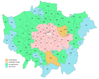
Boundaries
The borough bordered the metropolitan boroughs of Hackney, Stepney, and Bethnal Green to the west and north, and the county of Essex to the east. To the south, the River Thames formed borders with the metropolitan boroughs of Bermondsey, Deptford and Greenwich.
It included the districts of (from north to south):
History
In 1921 the Borough Council, under George Lansbury and the Poor Law Union were engaged in a dispute with the London County Council and central government over poor law rates - it wished to pay out of work people more than usually permitted; and to get wealthier West End boroughs to contribute to its expenses. Several councillors were imprisoned briefly in 1921 in relation to this. See Poplar Rates Rebellion.
In 1951 Poplar was chosen as the site of the Festival of Britain's 'Exhibition of Live Architecture'. The East End of London had been heavily bombed during the war and its reconstruction was showcased at the new Lansbury Estate. New building materials and planning concepts were demonstrated. The first example of 'live architecture' on the exhibition trail was the Trinity Congregational Church and Hall, just across from the main reception area with their Town Planning and Building Research Pavilions on East India Dock Road. The trail continued with the Lansbury Estate and Chrisp Street Market.
Population and area
Poplar covered an area of 2,328 acres (9.4 km2). The population as given in the census from 1801 to 1961 was:
Civil Parishes and Poplar Board of Works 1801-1899
Year[3] 1801 1811 1821 1831 1841 1851 1861 1871 1881 1891 Population 8,278 13,548 18,932 25,066 31,122 47,162 79,196 116,376 156,510 166,748 Metropolitan Borough 1900-1961
Year[4] 1901 1911 1921 1931 1941 1951 1961 Population 168,822 162,442 162,578 155,089 [5] 73,579 66,604 Borough seal
The borough had no coat of arms, using instead a seal originally designed for the Poplar District Board of Works, its predecessor, created by the Metropolis Management Act 1855. The seal depicted the emblems of the three parish vestries merged into the board.
The top shield was the seal of Poplar Vestry, and showed the 'Hibbert Gate' of the old West India Docks, with a sailing ship on top of the shield. A similar representation of the gate and ship formed the head of the vestry's civic mace, which was used by the board of works and borough council until 1965.
The shield on the left was the seal of Bow Vestry , and showed a bridge between two bows. This represented the bow-shaped bridge over the River Lea.
The shield on the right was the seal of Bromley St Leonard Vestry, and depicts the saint dressed as a bishop.
See also
References
- ^ a b c d e f Vision of Britain - Poplar population (area and density)
- ^ F. A. Youngs, Guide to the Local Administrative Units of England, Vol.I, 1979
- ^ Statistical Abstract for London, 1901 (Vol. IV)
- ^ Poplar MetB: Census Tables at Vision of Britain accessed on 4 Jan 2007
- ^ The census was suspended for World War II
- Vision of Britain website: Population tables for Poplar Borough [1]
External links
- Official Guide to the Metropolitan Borough of Poplar, 1927
- Poplar Town Hall on the Port Cities website
Local government districts abolished or transferred by the London Government Act 1963 London · CC Battersea · Bermondsey · Bethnal Green · Camberwell · Chelsea · Deptford · Finsbury · Fulham · Greenwich · Hackney · Hammersmith · Hampstead · Holborn · Islington · Kensington · Lambeth · Lewisham · Paddington · Poplar · Shoreditch · Southwark · St. Marylebone · St. Pancras · Stepney · Stoke Newington · Wandsworth · Westminster · Woolwich
Constituent parts of Greater LondonEssex Barking · Chigwell (part) · Chingford · Dagenham · East Ham · Hornchurch · Ilford · Leyton · Romford · Walthamstow · Wanstead and Woodford · West Ham
Hertfordshire Middlesex · CC Acton · Brentford and Chiswick · Ealing · Edmonton · Enfield · Feltham · Finchley · Friern Barnet · Harrow · Hayes and Harlington · Hendon · Heston and Isleworth · Hornsey · Ruislip-Northwood · Southall · Southgate · Tottenham · Twickenham · Uxbridge · Wembley · Willesden · Wood Green · Yiewsley and West Drayton
Kent Surrey Transfers Metropolitan Board of Works Districts Fulham · Greenwich · Hackney · Holborn · Lee/Plumstead · Lewisham · Limehouse · Poplar · St Giles · St Olave · St Saviour's · Strand · Wandsworth · Westminster · Whitechapel
Headquarters at Spring GardensIncorporated vestries Battersea · Bermondsey · Bethnal Green · Camberwell · Chelsea · Clerkenwell · Fulham · Hackney · Hammersmith · Hampstead · Islington · Kensington · Lambeth · Mile End Old Town · Newington · Paddington · Plumstead · Rotherhithe · St George Hanover Square · St George in the East · St Luke Middlesex · St Martin in the Fields · St Marylebone · St Pancras · Stoke Newington · Shoreditch · Southwark St George the Martyr · Westminster St Margaret and St John · Westminster St James · WoolwichUndertakings Major works Legislation Royal Commission on the City of London · Metropolis Management Act 1855 · Metropolis Toll Bridges Act 1877 · Metropolitan Board of Works (Money) Act 1885 · Metropolis Management Amendment Act 1885 · Local Government Act 1888 · London Government Act 1899People Categories:- Metropolitan boroughs of the County of London
- History of Tower Hamlets
- Districts (Metropolis)
- 1900 establishments in the United Kingdom
- 1965 disestablishments


Wikimedia Foundation. 2010.