- Chislehurst and Sidcup Urban District
-
Chislehurst and Sidcup Geography Status Urban district, civil parish 1951 area 8,959 acres (36.3 km2) 1961 area 8,959 acres (36.3 km2) History Created 1934 Abolished 1965 Succeeded by London Borough of Bexley
London Borough of BromleyDemography 1931 population 20,493 (equivalent area) 1961 population 86,892 Chislehurst and Sidcup Urban District was a local government district and civil parish in north west Kent, England from 1934 to 1965.
It was formed in 1934 from the former area of Chislehurst Urban District, Sidcup Urban District and part of Bromley Rural District.[1]
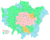
In 1965 the parish and urban district were abolished and the settlements split again so Chislehurst became part of the London Borough of Bromley while Sidcup and North Cray formed part of the London Borough of Bexley in Greater London.
References
- ^ Vision of Britain - Chislehurst and Sidcup UD
External links
- Ideal Homes - London Borough of Bexley
- Vision of Britain - Historic boundaries
Local government districts abolished or transferred by the London Government Act 1963 London · CC Battersea · Bermondsey · Bethnal Green · Camberwell · Chelsea · Deptford · Finsbury · Fulham · Greenwich · Hackney · Hammersmith · Hampstead · Holborn · Islington · Kensington · Lambeth · Lewisham · Paddington · Poplar · Shoreditch · Southwark · St. Marylebone · St. Pancras · Stepney · Stoke Newington · Wandsworth · Westminster · Woolwich
Constituent parts of Greater LondonEssex Barking · Chigwell (part) · Chingford · Dagenham · East Ham · Hornchurch · Ilford · Leyton · Romford · Walthamstow · Wanstead and Woodford · West Ham
Hertfordshire Middlesex · CC Acton · Brentford and Chiswick · Ealing · Edmonton · Enfield · Feltham · Finchley · Friern Barnet · Harrow · Hayes and Harlington · Hendon · Heston and Isleworth · Hornsey · Ruislip-Northwood · Southall · Southgate · Tottenham · Twickenham · Uxbridge · Wembley · Willesden · Wood Green · Yiewsley and West Drayton
Kent Surrey Transfers Coordinates: 51°25′N 0°5′E / 51.417°N 0.083°E
Categories:- History of Bromley
- History of Bexley
- Districts abolished by the London Government Act 1963
- Urban districts of England
- London geography stubs

Wikimedia Foundation. 2010.