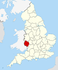
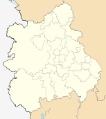
- Herefordshire
-
Not to be confused with Hertfordshire.For the UK Parliamentary constituency (abolished 1885), see Herefordshire (UK Parliament constituency).
Herefordshire 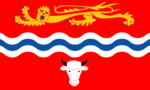
Geography Status Ceremonial county & Unitary district Origin Historic Region West Midlands Area
- Total
- Admin. councilRanked 26th
2,180 km2 (840 sq mi)
Ranked 7thAdmin HQ Hereford ISO 3166-2 GB-HEF ONS code 00GA NUTS 3 UKG11 Demography Population
- Total (2010 est.[1])
- Density
- Admin. councilRanked 45th
179,300
82 /km2 (210 /sq mi)
Ranked 94thEthnicity 99.1% White Politics 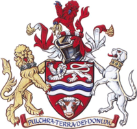
Herefordshire Council
http://www.herefordshire.gov.ukExecutive Conservative Members of Parliament 2Districts N/A
Herefordshire (
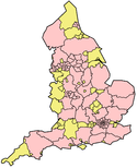
 /ˈhɛrɨfərdʃər/) is a historic and ceremonial county in the West Midlands region of England. For Eurostat purposes it is a NUTS 3 region (code UKG11) and is one of three counties that comprise the "Herefordshire, Worcestershire and Gloucestershire" NUTS 2 region. It also forms a unitary district known as the County of Herefordshire. It borders the English ceremonial counties of Shropshire to the north, Worcestershire to the east, Gloucestershire to the south-east, and the Welsh preserved counties of Gwent to the south-west and Powys to the west. Hereford is a cathedral city and is the county town; with a population of approximately 55,800 inhabitants it is also the largest settlement.
The county is one of the most rural and sparsely populated in England, with a population density of 82/km² (212/sq mi). The land use is predominantly agricultural and the county is well known for its fruit and cider production, and the Hereford cattle breed.
Contents
Constitution
From 1974 to 1998, Herefordshire was part of the former non-metropolitan county of Hereford and Worcester.
Herefordshire was reconstituted both as a new district (effective 19 July 1996) and as a new county (coextensive with the area of the aforementioned district) (effective 1 April 1998) by Statutory Instrument as defined in The Hereford and Worcester (Structural, Boundary and Electoral Changes) Order 1996.[2] This Order established Herefordshire as a unitary authority on the 1st April 1998, combining county and district functions into a single council. Herefordshire is also commonly called a unitary district, but this is not official nomenclature. Herefordshire is officially known as a unitary authority for local government purposes.[3] It is governed by Herefordshire Council which was created in 1998 with the new unitary district that absorbed the previous administrative areas of Leominster District Council, South Herefordshire District Council, Hereford City Council, parts of Hereford-Worcester County Council, and parts of Malvern Hills District Council.[4]
The Lieutenancies Act 1997 made Herefordshire a ceremonial county, covering the exact area of the unitary district.
History
Main article: History of HerefordshireHerefordshire is one of the 39 historic counties of England.
In 1974 it was merged with neighbouring Worcestershire to form the relatively short-lived Hereford and Worcester administrative county. Within this, Herefordshire was covered by the local government districts of South Herefordshire, Hereford, and part of Malvern Hills and Leominster districts.
The current ceremonial county and unitary district have broadly the same borders as the pre-1974 historic county.
Cities, towns and villages
Main article: List of places in HerefordshireThe major settlements in the county include Hereford, which is the county town and Herefordshire's only city, as well as the towns of Leominster, Ledbury, Ross-on-Wye, Kington and Bromyard.
See also Category:Towns in Herefordshire and Category:Villages in Herefordshire.
Council
The Council operates a cabinet-style council and is Conservative controlled. The Chairman is Councillor John Stone, the Cabinet Leader for Herefordshire is Councillor Roger Phillips. The Herefordshire Youth Council has been running for 4 Years, it is chaired by Amy Saunders.
The Cabinet Leader is appointed yearly by the full council of 58 councillors. The Cabinet Leader then picks their deputy and seven more councillors to form the executive cabinet. Each cabinet member makes the decisions about the portfolio that they are allocated.[5]
Elections to the council are held every 4 years. Elections are conducted under the FPTP system with 31 of the 40 wards returning 1 councillor and 9 returning 2. Elections have been held in 2000, 2003 and 2007, the next election shall occur in 2011.
Economy
This is a chart of trend of regional gross value added of Herefordshire at current basic prices published by the Office for National Statistics with figures in millions of British Pounds Sterling.[6]
Year Regional Gross Value Added[6] Agriculture[7] Industry[8] Services[9] 1995 1,622 218 567 836 2000 1,885 155 643 1,087 2003 2,216 185 708 1,323 ^ includes hunting and forestry
^ includes energy and construction
^ includes financial intermediation services indirectly measured
^ Components may not sum to totals due to rounding
Many well-known cider produces are based in Herefordshire. These include Weston's cider of Much Marcle, and Bulmer's cider, from Hereford, which produces the UK market leader Strongbow.
Employment
Most employment in Herefordshire is in agriculture, manufacturing and services. According to Herefordshire Council's online document "worklessness", 10% of people are unemployed in Herefordshire including out-of-work, homeless, ill and disabled and their carers. Cargill Meats and H.P Bulmers are two of the largest employers.
Education
Herefordshire has a comprehensive education system that also includes seven independent schools.[7] Most state schools are from 11-16. Sixth form provision is limited. Colleges of further and higher education in the county are:
- Hereford Cathedral School (Independent)
- Hereford Sixth Form College
- Hereford College of Arts
- Herefordshire College of Technology
- Lady Hawkins High School and Sixth Form College(Kington)
- John Masefield High School and Sixth Form College (Ledbury)
- John Kyrle High School and Sixth Form Centre (Ross-on-Wye)
- National School of Blacksmithing
- The Hereford Academy and Sixth Form
- Earl Mortimer College (previously known as The Minster College and Sixth Form) located in Leominster.
- Royal National College for the Blind
Agriculture
The agricultural economy has changed massively in recent years within the county. The county is on the western edge of England which has been historically pastoral as opposed to the east which was more arable.[citation needed]
Beef
Probably Hereford's most famous export is its beef cattle Hereford cattle. Herefords are docile but extremely hardy creatures and these attributes have led to their proliferation across the world, particularly the US, South America and Australia. The breed is so gentle that a Hereford bull has been used as the mascot for Hereford United Football Club for many years, led around packed stadiums prior to major matches.
Fruit
The county is famous for its apple and pear orchards, and its cider. There are many orchards around the county but not as many as there once were.
In the last few years, soft fruits such as strawberries have become a new and rapidly expanding area of the agricultural economy of the county. One of the main reasons for this was the introduction of the polytunnel or French tunnel. This allowed the strawberries to be grown for a far longer season and at a higher quality (with no blemishes from the rain). The strawberries are mainly picked by Eastern European workers who come over for the season to earn some money, more than they could working in their country of origin and with the bonus, for many of them, of learning or improving their English fluency. The polytunnels have been a major issue in the county, as some people see them as a "blot on the landscape".[8]
Although some polytunnel sites are technically illegal, Herefordshire Council has chosen to ignore legal ruling in the belief that if agriculture is to survive, then it must be allowed to innovate; otherwise, the industry will stagnate and the county will suffer.[9]
Dairy
There was a time when the majority of farms in the county would have had dairy cattle for milk production. The cost of investing in new equipment, long hours, BSE, foot-and-mouth disease and mainly the falling milk prices have meant that the milk production has drastically reduced, with only a few farms still in dairy farming.[citation needed]
Potatoes
As mentioned above, the county is historically pastoral. The soils are mostly clay, meaning that large scale potato production was very difficult, as tractors were not powerful enough to pull the large machinery required to harvest the crop. Around the early 1990s new technology and more powerful machines overcame this problem. Potato production started to increase, fuelled by a few other key factors: The previously pastoral soils had not had potatoes grown in them; consequently they were not infected with eelworm (Heterodera rostochiensis and Heterodera pallida), which in the east of England had to be sprayed against weekly (a large cost). Also, the clay soil produced an unblemished potato of the highest grade. The intensive nature of the crop meant that potatoes could be grown viably on a given field in only one of every five years. Because potato growers always needed more land than they owned, they rented extra. This demand for rental fields came at a time when the rest of the industry was struggling and in serious decline. The potato farmers' rents of £300-500 per acre (as opposed to normally £80 per acre) were very helpful to many farmers in a difficult period.[citation needed]
Emblems
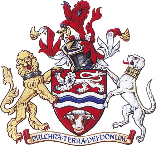
Coat of arms
Herefordshire County Council was granted a coat of arms on February 28, 1946.[10] The arms became obsolete in 1974 on the abolition of the council, but were transferred to the present Herefordshire Council by Order in Council in 1997.[11]
The arms are blazoned as follows:
Gules on a fesse wavy between in chief a lion passant guardant argent and in base a Herefordshire bull's head caboshed proper, a bar wavy azure; and for a Crest on a wreath of the colours a demi lion rampant gules holding in the sinister claw a fleece or; and for Supporters, on the dexter side a lion guardant or gorged with a wreath of hops fructed proper and on the sinister a talbot argent gorged with a collar or charged with three apples proper.[10]
The red colouring of the shield is taken from the arms of the City of Hereford. The red colour also represents the red earth of Herefordshire. The silver and blue wave across the centre of the shield represents the River Wye. The lions that form parts of the arms, crest and supporters are also taken from Hereford's arms. The agricultural produce of Herefordshire is represented by the bull's head, fleece, hops and apples. The talbot dog comes from the heraldry of the Talbot family, Marcher Lords of Shrewsbury and also from that of Viscount Hereford.
The Latin motto is: Pulchra terra Dei donum or This fair land is the gift of God.[12]
County flower
As part of a competition organised by the charity Plantlife to raise awareness of conservation issues, the public were asked to vote for "county flowers" that they felt best represented their county. Mistletoe was announced as the winning choice for Herefordshire in 2004.[13] The emblem has no official status, and has not been widely adopted. Herefordshire Council uses a logo consisting of a green apple.[14]
Sport
Perhaps the most famous sporting team in Herefordshire is Hereford United football club, who are members of the Football League and play at Edgar Street stadium in the city of Hereford. The club was founded in 1924 on the merger of two local teams - St Martin's and RAOC - and became members of the Birmingham Combination League.[15]The club then made its way upwards to the Southern Football League, finally gaining election to the Football League in 1972 - the same year that the club famously defeated First Division side Newcastle United in an FA Cup tie. Two successive promotions saw the club reach the Second Division in 1978, but two successive relegations followed and saw the club side back into the Fourth Division.[16]Despite being situated within England, the club has competed in the Welsh Cup on a number of occasions, winning the trophy in 1990. The club suffered relegation from the Football League in 1997 and fell into the Football Conference,[17]not regaining its Football League status until 2006. The club currently plays in Football League Two - the fourth highest division of English football.[18]
Places of interest
Key 
Abbey/Priory/Cathedral 
Accessible open space 
Amusement/Theme Park 
Castle 
Country Park 
English Heritage 
Forestry Commission 
Heritage railway 
Historic House 

Museum (free/not free) 
National Trust 
Zoo - Abbey Dore Court

- Berrington Hall

- Courtyard Centre for the Arts - Hereford's main theatre and art performance centre
- Croft Castle
- Dore Abbey
- Eastnor Castle
- Edgar Street (Football Stadium Home to Hereford United F.C.)
- Eye Manor
- Goodrich Castle
- Hampton Court
- Hellens Manor
- Hereford Cathedral
- Malvern Hills

- Herefordshire Beacon
- Priory Church
- Sutton Walls Hill Fort
Transport
Road
The M50, one of the first motorways to be built in the UK, runs through the south of the county and, with the A40 dual carriageway, forms part of the major route linking South Wales with Gloucester, Oxford and London
The hilly nature of the terrain in Mid Wales means that the main ground transport links between North Wales and South Wales run through Herefordshire. The other trunk roads in Herefordshire, the A49 and the A465, form part of these north–south routes as well as catering for local traffic. These are single-carriageway roads and mean that travelling through the county is often slow.
Railways
The Welsh Marches Railway Line also runs north–south with passenger trains operated by Arriva Trains Wales offering links to Manchester as well as to North and South Wales. Hereford is the western end of the Cotswold Line and also is operated by Arriva Trains Wales which runs via Worcester with through services to Oxford and London (operated by First Great Western) and to Birmingham (operated by London Midland).
Former routes which are now closed were Ledbury to Gloucester; Hereford to Ross-on-Wye and onward to Gloucester and Monmouth; Hereford to Hay-on-Wye; Pontrilas to Hay-on-Wye; Leominster to New Radnor; Eardisley to Presteigne; and Leominster to Worcester via Bromyard.
Air
There are no airports with scheduled air services in Herefordshire. Birmingham, Cardiff and Bristol international airports are the nearest. The RailAir[19] coach operated by First Great Western provides connections to London Heathrow via Reading station. Shobdon Aerodrome near Leominster is a centre for general aviation and gliding. Hot air ballooning is also popular with Eastnor Castle being one of the favourite launch sites in the area.
Waterways
Historically, the rivers Wye and Lugg were navigable but the wide seasonal variations in water levels mean that few craft larger than canoes and coracles are now used. There are canoe centres at The Boat House, Glasbury-on-Wye (in Powys, Wales), the Hereford Youth Service and Kerne Bridge in Ross-on-Wye, as well as rowing clubs in Hereford and Ross-on-Wye.
The early 19th century saw the construction of two canals, The Herefordshire and Gloucestershire Canal[20] and The Leominster & Stourport Canal[21] but these were never successful and there are now few remains to be seen. The Herefordshire and Gloucestershire Canal is currently the subject a restoration project, which includes the construction of a new canal basin in Hereford city centre as part of the regeneration of the Edgar Street Grid. The project, however, is being undertaken by a small voluntary group and there is no expected date for any part of the canal to re-open for boating.
Notable people
- Richard Ashcroft, songwriter and lead singer of The Verve
- Monty Don, BBC TV presenter
- Robert Devereux, 2nd Earl of Essex, favourite of Queen Elizabeth I
- Sir Edward Elgar, famous composer
- David Garrick, renowned actor of the 18th century
- Lady Godiva, wife of Leofric, Earl of Mercia
- Harold Godwineson, Earl of Hereford and last Anglo-Saxon King of England
- Ellie Goulding, singer
- Nell Gwynne, mistress of King Charles II of England
- Richard Hammond, Top Gear presenter
- Terry Jenkins, professional darts player
- St. John Kemble (martyr) Catholic priest
- Francis Kilvert, 19th century diarist
- Albert Lee, legendary country guitarist
- John Masefield, Poet Laureate
- George Nash, Archaeologist, writer and BBC Radio 4 presenter
- Sidney Nolan, Australian Artist (from late 1970s)
- John Oldcastle, Lollard leader and basis for Shakespeare's character Falstaff
- Blanche Parry, Lady in Waiting to Queen Elizabeth I
- Peter Scudamore, jockey
- Tom Spring, bare-knuckle boxer, champion of England in 19th century
- Thomas Traherne, 17th century poet
- Alfred Watkins, pioneering archaeologist and photographer
See also
- Lord Lieutenant of Herefordshire
- High Sheriff of Herefordshire
- Herefordshire List of MPs
- List of schools in Herefordshire
References
- ^ "Table 8a Mid-2010 Population Estimates: Selected age groups for local authorities in the United Kingdom; estimated resident population.". Population Estimates for UK, England and Wales, Scotland and Northern Ireland, Mid-2010. Office for National Statistics. 3 June 2011. http://www.ons.gov.uk/ons/publications/re-reference-tables.html?edition=tcm%3A77-231847. Retrieved 1 October 2011.
- ^ "''The Hereford and Worcester (Structural, Boundary and Electoral Changes) Order 1996''". Opsi.gov.uk. 2010-07-16. http://www.opsi.gov.uk/si/si1996/Uksi_19961867_en_2.htm. Retrieved 2010-09-25.
- ^ Members of Parliament by county or unitary authority[dead link]
- ^ Official Hereford Council website. Retrieved 21 May 2009.
- ^ "Constitution: Part 2". Herefordshire County Council. http://www.herefordshire.gov.uk/docs/002_Part_2_Articles__Dec09.pdf. Retrieved 2010-05-05.[dead link]
- ^ "Microsoft Word — Regional GVA Article.doc" (PDF). http://www.statistics.gov.uk/downloads/theme_economy/RegionalGVA.pdf. Retrieved 2010-09-25.
- ^ [1]
- ^ "CPC — Press". Polytunnelcontrol.org.uk. http://www.polytunnelcontrol.org.uk/press.htm. Retrieved 2010-09-25.
- ^ "THE QUEEN ON THE APPLICATION OF WYE VALLEY ACTION ASSOCIATION LIMITED v HEREFORDSHIRE COUNCIL and EC DRUMMOND & SON". [2009] EWHC 3428 (Admin), [2010] Env LR 18, [2010] 2 All ER 863. BAILII#BAILII. 2009-12-18. http://www.bailii.org/ew/cases/EWHC/Admin/2009/3428.html. Retrieved 2010-08-24. "the Council, in my judgment, have made an error of law in relation to their findings that this development was not a project within Schedule 2 and such an error of law, as I set out above, means that quashing of the decision must follow, because the Council have failed to undertake an environmental impact assessment of the process. They failed to go on to consider whether or not the project would have significant environmental effects and, therefore, whether or not it required an environmental statement. In those circumstances, there is no need or purpose for me to consider the subsidiary ground which was raised in relation to the reasons provided with the screening opinion since my conclusions in respect of the first element of the ground of challenge disposes of the case and the planning consent must be quashed."
- ^ a b Geoffrey Briggs, Civic and Corporate Heraldry, London, 1971
- ^ "''The Local Authorities (Armorial Bearings) (No. 2) Order 1997'', www.opsi.gov.uk, accessed October 31, 2007". Opsi.gov.uk. 1974-04-01. http://www.opsi.gov.uk/si/si1997/19972618.htm. Retrieved 2010-09-25.
- ^ C Wilfrid Scott-Giles, Civic Heraldry of England and Wales, 2nd edition, London, 1953
- ^ Kirby, Alex (2004-05-05). "''UK counties choose floral emblems'', BBC News online, accessed October 31, 2007". BBC News. http://news.bbc.co.uk/2/hi/science/nature/3684291.stm. Retrieved 2010-09-25.
- ^ "Herefordshire Council Homepage, accessed October 31, 2007". Herefordshire.gov.uk. http://www.herefordshire.gov.uk/homepage.asp. Retrieved 2010-09-25.
- ^ [2]
- ^ [3]
- ^ [4]
- ^ [5]
- ^ "Welcome to". Railair.com. http://www.railair.com. Retrieved 2010-09-25.
- ^ "Hereford & Gloucester Canal". Smr.herefordshire.gov.uk. http://www.smr.herefordshire.gov.uk/post-medieval/canals/hereford_gloucester.htm. Retrieved 2010-09-25.
- ^ "Leominster & Stourport Canal". Smr.herefordshire.gov.uk. http://www.smr.herefordshire.gov.uk/post-medieval/canals/leominster_stourport.htm. Retrieved 2010-09-25.
External links
- Herefordshire at the Open Directory Project
- Herefordshire County Portal Local events, jobs, photos and news
- Herefordshire Libraries 10 Libraries across Herefordshire
- Herefordshire & Worcestershire Earth Heritage Trust Records and protects the county's Earth Heritage
Districts of the West Midlands Region Herefordshire Herefordshire
Shropshire Staffordshire Warwickshire West Midlands Birmingham · Coventry · Dudley · Sandwell · Solihull · Walsall · Wolverhampton
Worcestershire Bromsgrove · Malvern Hills · Redditch · Worcester · Wychavon · Wyre Forest
Unitary authorities County of HerefordshireMajor settlements Bromyard • Hereford • Kington • Ledbury • Leominster • Ross-on-Wye
See also: List of civil parishes in HerefordshireRivers Topics Unitary authorities of England Districts Bath and North East Somerset · Bedford · Blackburn with Darwen · Blackpool · Bournemouth · Bracknell Forest · Brighton and Hove · Bristol · Central Bedfordshire · Cheshire East · Cheshire West and Chester · Cornwall · County Durham · Darlington · Derby · East Riding of Yorkshire · Halton · Hartlepool · Herefordshire · Isle of Wight · Kingston upon Hull · Leicester · Luton · Medway · Middlesbrough · Milton Keynes · North East Lincolnshire · North Lincolnshire · North Somerset · Northumberland · Nottingham · Peterborough · Plymouth · Poole · Portsmouth · Reading · Redcar and Cleveland · Rutland · Shropshire · Slough · Southampton · Southend-on-Sea · South Gloucestershire · Stockton-on-Tees · Stoke-on-Trent · Swindon · Telford and Wrekin · Thurrock · Torbay · Warrington · West Berkshire · Wiltshire · Windsor and Maidenhead · Wokingham · York
Councils Bournemouth · Cornwall · Herefordshire · Isle of Wight · Kingston upon Hull · Leicester · Middlesbrough · Northumberland · Nottingham · Poole · Rutland · Shropshire · Slough · Thurrock · Wiltshire
Categories:- Herefordshire
- Unitary authorities of England
- Local government districts of the West Midlands (region)
- NUTS 3 statistical regions of the United Kingdom


Wikimedia Foundation. 2010.