- Nottinghamshire
-
Nottinghamshire 
Motto of County Council: Sapienter Proficiens (Progress with wisdom) 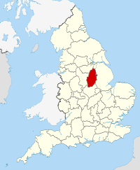
Geography Status Ceremonial & (smaller) Non-metropolitan county Origin Historic Region East Midlands Area
- Total
- Admin. council
- Admin. areaRanked 27th
2,160 km2 (830 sq mi)
Ranked 24th
2,085 km2 (805 sq mi)Admin HQ West Bridgford ISO 3166-2 GB-NTT ONS code 37 NUTS 3 UKF15/16 Demography Population
- Total (2010 est.)
- Density
- Admin. council
- Admin. pop.Ranked 15th
1,086,500
503 /km2 (1,300 /sq mi)
Ranked 10th
779,800Ethnicity 94.1% White
2.5% S. Asian
1.5% Afro-Carib.Politics 
Nottinghamshire County Council
http://www.nottscc.gov.uk/Executive Conservative Members of Parliament Districts 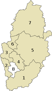
Nottinghamshire (
 /ˈnɒtɪŋəmʃər/ or /ˈnɒtɪŋəmʃɪər/; abbreviated Notts) is a county in the East Midlands of England, bordering South Yorkshire to the north-west, Lincolnshire to the east, Leicestershire to the south, and Derbyshire to the west. The traditional county town is Nottingham, though the county council is based in West Bridgford in the borough of Rushcliffe, at a site facing Nottingham over the River Trent.
The districts of Nottinghamshire are Ashfield, Bassetlaw, Broxtowe, Gedling, Mansfield, Newark and Sherwood, and Rushcliffe. The City of Nottingham was administratively part of Nottinghamshire between 1974 and 1998 but is now a unitary authority, remaining part of Nottinghamshire for ceremonial purposes.
As of 2006 the county is estimated to have a population of just over one million. Over half of the population of the county live in the Greater Nottingham conurbation (which continues into Derbyshire).[1] The conurbation has a population of about 650,000, though less than half live within the city boundaries.
Contents
History
Main article: History of NottinghamshireNottinghamshire lies on the Roman Fosse Way, and there are Roman settlements in the county, for example at Mansfield. The county was settled by Angles around the 5th century, and became part of the Kingdom, and later Earldom, of Mercia. However, there is evidence of Saxon settlement at Oxton, near Nottingham, and Tuxford, east of Sherwood Forest. The name first occurs in 1016, but until 1568 the county was administratively united with Derbyshire, under a single Sheriff. In Norman times the county developed malting and woollen industries. During the industrial revolution canals and railways came to the county, and the lace and cotton industries grew. In the 19th century collieries opened and mining became an important economic sector, though these declined after the 1984-5 miners' strike.
Until 1610, Nottinghamshire was divided into eight Wapentakes. Sometime between 1610 and 1719 they were reduced to six – Newark, Bassetlaw, Thurgarton, Rushcliffe, Broxtowe and Bingham, some of these names still being used for the modern districts. Oswaldbeck was absorbed in Bassetlaw, of which it forms the North Clay division, and Lythe in Thurgarton.
Nottinghamshire is famous for its involvement with the legend of Robin Hood. This is also the reason for the amount of tourists who visit places like Sherwood Forest, City of Nottingham and the surrounding villages in Sherwood Forest. To reinforce the Robin Hood connection, the University of Nottingham in 2010 has begun the Nottingham Caves Survey with the goal "to increase the tourist potential of these sites". The project "will use a 3D laser scanner to produce a three dimensional record of more than 450 sandstone caves around Nottingham".[2]
Nottinghamshire was mapped first by Christopher Saxton in 1576, the first fully surveyed map of the county was by John Chapman who produced Chapman's Map of Nottinghamshire in 1774.[3] The map was the earliest printed map at a sufficiently useful scale (one statute mile to one inch) to provide basic information on village layout and the existence of landscape features such as roads, milestones, tollbars, parkland and mills.
Physical geography
Nottinghamshire, like Derbyshire and South Yorkshire, sits on extensive coal measures, up to 900 metres (3,000 feet) thick and occurring largely in the north of the county. There is an oilfield near Eakring. These are overlaid by sandstones and limestones in the west and clay in the east.[4] The north of the county is part of the Humberhead Levels lacustrine plain. The centre and south west of the county, around Sherwood Forest, features undulating hills with ancient oak woodland. Principal rivers are the Trent, Idle, Erewash and Soar. The Trent, fed by the Soar and Erewash, and Idle, composed of many streams from Sherwood Forest, run through wide and flat valleys, merging at Misterton. Strawberry Bank in Huthwaite is the highest natural point in Nottinghamshire at 203m.,[5] while Silverhill, a spoil heap left by the former Silverhill colliery, is the highest man-made point at 205m.[6]
Nottinghamshire is sheltered by the Pennines to the west, so receives relatively low rainfall at 641–740 mm (25–29 in) annually.[7] The average temperature of the county is 8.8-10.1 degrees Celsius (48-50 degrees Fahrenheit).[8] The county receives between 1321 and 1470 hours of sunshine per year.[9]
Politics
See also: Nottinghamshire Local Elections
Nottinghamshire is represented by eleven members of parliament, of which seven are members of the Labour Party, and four are Conservatives. Kenneth Clarke of Rushcliffe is a former Conservative Chancellor of the Exchequer and the present Lord High Chancellor.
Following the 2009 election, the County Council is Conservative controlled, a gain from Labour. There are 67 councillors, 43 of which are Conservative, Mansfield Independents, UKIP and other various Independents grouped, 15 are Labour and 9 are Liberal Democrat.[10] Local government is devolved to seven local borough and district councils, Bassetlaw, Gedling, Newark and Sherwood and Rushcliffe are Conservative controlled while Mansfield is controlled by the local Independent forum. Ashfield and Broxtowe have no overall control but are led by the Labour and the Liberal Democrat groups respectively. In 2007, Nottinghamshire County Council won an Ashden Award for their work converting coal-fired boilers in schools to burn wood pellets.[11]
Political control
Since the foundation of Nottinghamshire County Council in 1973 political control of the council has been held by the following parties:[12]
Party in control Years Labour 1973–1977 Conservative 1977–1981 Labour 1981–2009 Conservative 2009 - present Economy and industry
In 1998 Nottinghamshire had a GDP per-capita of £12,000, and a total GDP of £12,023 million. This is compared to a per-capita GDP of £11,848 for the East Midlands, £12,845 for England and £12,548 for the United Kingdom. Nottingham has a GDP per-capita of £17,373, North Nottinghamshire £10,176, and South Nottinghamshire £8,448.[13] In October 2005 the United Kingdom had 4.7% unemployment, the East Midlands 4.4%, and the Nottingham commuter belt area 2.4%.[14]
Education
See also: List of schools in Nottinghamshire
Secondary Education
The county has comprehensive secondary education with 47 state secondary schools, as well as 10 independent schools. The City of Nottingham LEA has 18 state schools and 6 independent schools, not including sixth form colleges.
9,700 pupils took GCSEs in the Nottinghamshire LEA in 2007. The best results were from the West Bridgford School, closely followed by Rushcliffe Comprehensive School and the Minster School in Southwell. The lowest performing school was the Queen Elizabeth's Endowed School in Mansfield. In Nottingham, the best results came from the Trinity Catholic School and the Fernwood School in Wollaton.
At A-level, the highest performing institution was The Becket School, followed by the West Bridgford School. Some of the county's best results tend to come from the all-male Nottingham High School, closely followed by the all-female Nottingham High School for Girls.
Higher education
See also: University of Nottingham, Nottingham Trent University
Nottingham Trent University is one of the most successful post-1992 universities in the UK. The University of Nottingham is a Russell Group university and well-renowned, offering one of the broadest selections of courses in the UK. Both universities combine to make Nottingham one of England's largest student cities. Nottingham Trent University also has an agricultural college near Southwell, while the University of Nottingham has one at Sutton Bonington.
 National and County cricket player Harold Larwood.
Culture
Nottinghamshire contains the ancestral home of the poet Lord Byron, Newstead Abbey, which he sold in 1818. It is now owned by Nottingham City Council and open to the public. The acclaimed author D. H. Lawrence was from Eastwood in Nottinghamshire. Toton was the birthplace and home of English folk singer-songwriter Anne Briggs, well known for her song 'Black Waterside'. The north of the county is also noteworthy for its connections with the Pilgrim Fathers. William Brewster, for example, came from the village of Scrooby and was influenced by Richard Clyfton, who preached at Babworth.
Nottinghamshire County Cricket Club are a first class cricket club who play at Trent Bridge in West Bridgford. They won the County Championship in 2005. Notable football teams within Nottinghamshire include: Nottingham Forest, a Championship club, Notts County, currently in League One, and Mansfield Town, a Conference National side. Other notable sporting teams are the Nottingham Rugby Football Club and the Nottingham Panthers Ice Hockey Club.
Nottinghamshire has international twinning arrangements with the province of Wielkopolska (Greater Poland) in western Poland, and with the province's capital city, Poznań.[15]
Settlements and communications
 The council house and a tram in Nottingham market square.
See also: List of Places in Nottinghamshire
The traditional county town, and the largest settlement in the historic and ceremonial county boundaries, is Nottingham. The City is now administratively independent, but suburbs including Arnold, Carlton, West Bridgford, Beeston and Stapleford are still within the administrative county, and West Bridgford is now home of the county council.
There are several market towns in the county. Newark-on-Trent is a bridging point of the Fosse Way and River Trent, but is actually an Anglo-Saxon market town with a now ruined castle. Mansfield, the second-largest settlement in the county, sits on the site of a Roman settlement, but grew after the Norman Conquest. Worksop, in the north of the county, is also an Anglo-Saxon market town which grew rapidly in the industrial revolution with the arrival of canals and railways and the discovery of coal. Mansfield and Worksop have suffered from the decline of mining since the 1984-5 miners' strike. Other market towns include Arnold, Bingham, Hucknall, Kirkby-in-Ashfield, and Retford.
The main railway in the county is the Midland Main Line which links London to Sheffield via Nottingham. The Robin Hood Line between Nottingham and Worksop serves several villages in the county. The East Coast Main Line from London to Doncaster, Leeds, York, Newcastle-upon-Tyne and Scotland serves the eastern Nottinghamshire towns of Newark and Retford The M1 motorway runs through the county, connecting Nottingham to London, Leeds and Leicester by road.
The A1 road follows for the most part the path of the Great North Road, although in places it diverges from the historic route where towns have been bypassed. Retford was by-passed in 1961 and Newark-on-Trent was by-passed in 1964, and the A1 now runs between Retford and Worksop past the village of Ranby. Many historic coaching inns can still be seen along the traditional route.
East Midlands Airport is just outside the county in Leicestershire, while the Robin Hood Airport lies within the historic boundaries of Nottinghamshire. These airports serve the county and several of its neighbours. Together the airports have services to most major European destinations, and East Midlands Airport now also has services to North America and the Caribbean. As well as local bus services throughout the county, Nottingham and its suburbs have a tram system, Nottingham Express Transit.
Places of interest
- Clumber Park
- Creswell Crags
- Rufford Country Park
- Rushcliffe Country Park
- Southwell Minster
- Sherwood Forest
- Ye Olde Trip To Jerusalem
- Hawton Church
- Nottingham Castle
- Wollaton Hall
- Welbeck Abbey
- Newstead Abbey
- Sherwood Observatory
- The Harley Gallery
See also
References
- ^ "Conurbation of Greater Nottingham renamed". Telegraph.co.uk. 2010-06-23. http://www.telegraph.co.uk/news/newstopics/howaboutthat/7850291/Council-chief-bans-use-of-Greater-Nottingham-for-Core-City-Area.html. Retrieved 2010-09-25.
- ^ "Laser to scan Robin Hood's prison under Nottingham city". BBC News. 2010-04-20. http://news.bbc.co.uk/local/nottingham/hi/people_and_places/history/newsid_8630000/8630926.stm. Retrieved 2010-09-25.
- ^ Chapman's Map of Nottinghamshire 1774. Nottinghamshire County Council ISBN 0-902751-46-8.
- ^ Encyclopædia Britannica, 1911. "Nottinghamshire, Geology". Retrieved 2005-12-11.
- ^ Haran, Brady (25 June 2004). "Experiencing the highs and lows". BBC News. http://news.bbc.co.uk/1/hi/england/3827507.stm. Retrieved 18 November 2010.
- ^ "Nottinghamshire". Livefortheoutdoors.com. http://www.livefortheoutdoors.com/Destinations/Search-Results/UK/England/East-Midlands/Nottinghamshire/. Retrieved 18 November 2010.
- ^ Met Office, 2000. Annual average rainfall for the United Kingdom.
- ^ Met Office, 2000. Annual average temperature for the United Kingdom.
- ^ Met Office, 2000. Annual average sunshine for the United Kingdom.
- ^ "Nottinghamshire County Council, 2009". Nottinghamshire.gov.uk. 2010-04-12. http://www.nottinghamshire.gov.uk/home/your_council/councilelections/electionresults.htm. Retrieved 2010-09-25.
- ^ Ashden Awards. "Wood fuel heating for schools". Retrieved 2009-05-22.
- ^ "Nottinghamshire". BBC News Online. 19 April 2009. http://news.bbc.co.uk/1/shared/bsp/hi/elections/local_council/09/html/3873.stm. Retrieved 2009-09-25.
- ^ Office for National Statistics, 2001. Regional Trends 26 ch:14.7 (PDF). Retrieved 2005-12-24.
- ^ East Midlands Observatory, 2005. Labour Market Statistics for October 2005. Retrieved 2005-12-24.
- ^ Nottinghamshire County Council. Transnational partnerships.
External links
- Visit Nottinghamshire
- Nottinghamshire County Council
- BBC Nottingham
- Nottinghamshire Police
- Nottingham Caves Survey
Neighbouring counties 
South Yorkshire South Yorkshire, Lincolnshire Lincolnshire Derbyshire 
Lincolnshire  Nottinghamshire

Derbyshire
LeicestershireLeicestershire Leicestershire Ceremonial county of Nottinghamshire Unitary authorities Boroughs or districts Major settlements Arnold · Beeston · Bingham · Bircotes · Blidworth · Carlton · Cotgrave · Eastwood · Harworth · Hucknall · Kimberley · Kirkby-in-Ashfield · Mansfield · Mansfield Woodhouse · Netherfield · Newark · Nottingham · Ollerton · Rainworth · Retford · Ruddington · Stapleford · Southwell · Sutton-in-Ashfield · West Bridgford · Worksop
See also: List of civil parishes in NottinghamshireTopics Categories:- Nottinghamshire
- Non-metropolitan counties
- East Midlands


Wikimedia Foundation. 2010.