- Buckinghamshire
-
For other uses, see Buckinghamshire (disambiguation).
Buckinghamshire 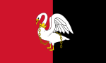
Flag of Buckinghamshire County Council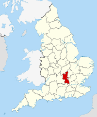
Geography Status Ceremonial & (smaller) Non-metropolitan county Origin Historic Region South East England Area
- Total
- Admin. council
- Admin. areaRanked 32nd
1,874 km2 (724 sq mi)
Ranked 33rd
1,565 km2 (604 sq mi)Admin HQ Aylesbury; Milton Keynes ISO 3166-2 GB-BKM ONS code 11 NUTS 3 UKJ13 Demography Population
- Total (2010 est.)
- Density
- Admin. council
- Admin. pop.Ranked 30th
739,600
395 /km2 (1,020 /sq mi)
Ranked 25th
498,100Ethnicity 91.7% White
4.3% S. Asian
1.6% BlackPolitics Buckinghamshire County Council; Borough of Milton Keynes
http://www.buckscc.gov.uk/ ; http://www.miltonkeynes.gov.uk/Executive Conservative Members of Parliament - Steve Baker (C)
- John Bercow (S)
- Cheryl Gillan (C)
- Dominic Grieve (C)
- Mark Lancaster (C)
- David Lidington (C)
- Iain Stewart (C)
Districts 
- South Bucks
- Chiltern
- Wycombe
- Aylesbury Vale
- Milton Keynes (Unitary)
Buckinghamshire (
 /ˈbʌkɪŋəmʃər/ or /ˈbʌkɪŋəmʃɪər/; archaically the County of Buckingham; abbreviated Bucks) is a ceremonial and non-metropolitan home county in South East England. The county town is Aylesbury, the largest town in the ceremonial county is Milton Keynes and largest town in the non-metropolitan county is High Wycombe.
The area under the control of Buckinghamshire County Council, or shire county, is divided into four districts—Aylesbury Vale, Chiltern, South Bucks and Wycombe. The Borough of Milton Keynes is a unitary authority and forms part of the county for various functions such as Lord Lieutenant but does not come under county council control. The ceremonial county, the area including Milton Keynes borough, borders Greater London (to the south east), Berkshire (to the south), Oxfordshire (to the west), Northamptonshire (to the north), Bedfordshire (to the north east) and Hertfordshire (to the east).
Sections of the county closer to London are part of the Metropolitan Green Belt, which limits development. It is the location of the nationally important Pinewood Studios and Dorney Lake, which will be holding the rowing events at the 2012 Summer Olympics. It is also well known for the new town of Milton Keynes and the Chiltern Hills area of outstanding natural beauty.
Contents
History
Main article: History of Buckinghamshire Map of Bucks (1904)
The name Buckinghamshire is Anglo-Saxon in origin and means The district (scire) of Bucca's home. Bucca's home refers to Buckingham in the north of the county, and is named after an Anglo-Saxon landowner. The county has been so named since about the 12th century; however, the county itself has existed since it was a subdivision of the kingdom of Mercia (585–919).
The history of the area, though, predates the Anglo-Saxon period and the county has a rich history starting from the Celtic and Roman periods, though the Anglo-Saxons perhaps had the greatest impact on Buckinghamshire: the geography of the rural county is largely as it was in the Anglo-Saxon period. Later, Buckinghamshire became an important political arena, with King Henry VIII intervening in local politics in the 16th century and just a century later the English Civil War was reputedly started by John Hampden in mid-Bucks.[1]
Historically, the biggest change to the county came in the 19th century, when a combination of cholera and famine hit the rural county, forcing many to migrate to larger towns to find work. Not only did this alter the local economical picture, it meant a lot of land was going cheap at a time when the rich were more mobile and the leafy Bucks became a popular rural idyll: an image it still has today. Buckinghamshire is a popular home for London commuters, leading to greater local affluence; however, some pockets of relative deprivation remain.[2]
Geography
The county can be split into two sections geographically. The south leads from the River Thames up the gentle slopes of the Chiltern Hills to the more abrupt slopes on the northern side leading to the Vale of Aylesbury, a large flat expanse of land, which includes the path of the River Great Ouse.
Waterways
Rivers
The county includes two of the four longest rivers in England. The River Thames forms the southern boundary with Berkshire, which has crept over the border at Eton and Slough meaning the river is no longer the sole boundary between the two counties. The River Great Ouse begins just outside the county in Northamptonshire and flows east through Buckingham, Milton Keynes and Olney.
Canals
The main branch of the Grand Union Canal flows through the county as do its arms to Slough, Aylesbury, Wendover (disused) and Buckingham (disused). The canal has been incorporated into Milton Keynes.
Landscape
The two highest points in Buckinghamshire are Haddington Hill in Wendover Woods (a stone marks its summit) at 267 metres (876 ft) above sea level, and Coombe Hill near Wendover at 260 metres (850 ft).
Demography
Main articles: Lord Lieutenant of Buckinghamshire, High Sheriff of Buckinghamshire, and Ceremonial counties of EnglandThe ceremonial county of Buckinghamshire consists of the area administered by Milton Keynes Borough Council as well as that administered by Buckinghamshire County Council. The ceremonial county has a Lord Lieutenant and a High Sheriff. Currently the Lord Lieutenant of Buckinghamshire is Sir Henry Aubrey-Fletcher and the High Sheriff of Buckinghamshire is Amanda Nicholson. The Custos rotulorum has been combined with the duties of Lord Lieutenant since 1702.
Buckinghamshire Districts District Main Towns Population (2006 estimate) Population (2007 estimate) Population (2008 estimate) Area Population Density (2008) Population Estimate 2026[3][4] Aylesbury Vale Aylesbury, Buckingham 172,000 174,100 176,000 902.75 km² 195/km² 213,000 Wycombe High Wycombe, Marlow 161,300 161,400 161,500 324.57 km² 498/km² 165,000 Chiltern Amersham, Chesham 90,300 90,800 90,900 196.35 km² 463/km² 89,000 South Bucks Beaconsfield, Burnham 63,700 64,300 64,800 141.28 km² 459/km² 63,800 TOTAL Non-Metropolitan N/A 487,300 490,600 493,200 1565 km² 315/km² 530,800 Milton Keynes (borough) Milton Keynes, Newport Pagnell 224,800 228,400 232,200 308.63 km² 752/km² 323,146 TOTAL Ceremonial N/A 712,100 719,000 725,400 1874 km² 387/km² 853,946 Population figures for 2006 from the Office for National Statistics[5] as are figures for 2007 estimates[6] and 2008.[7] See List of English districts by population for a full list of every English district.
As can be seen from the table, the Vale of Aylesbury and borough of Milton Keynes have been identified as growth areas, with a population surge of almost 50,000 people in Aylesbury Vale between 2006 and 2026 and 100,000 people in Milton Keynes within twenty years. The population of Milton Keynes is expected to reach almost 350,000 by 2031.
Buckinghamshire is split into civil parishes.
Politics
At present, the county has two top-level administrations: Buckinghamshire County Council, which administers about four fifths of the county (see map above) and the Borough of Milton Keynes, a unitary authority, which administers the remaining fifth. There are four district councils that are subsidiary to the county council: Aylesbury Vale, Chiltern, South Bucks and Wycombe.
Buckinghamshire County Council
 Bucks County Council's County Hall
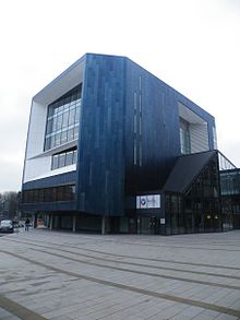
The county council was founded in 1889 with its base in new municipal buildings in Walton Street, Aylesbury (which are still there). In Buckinghamshire, local administration is run on a two-tier system where public services are split between the county council and a series of district councils.
In the 1960s the council moved into new premises: a 15-storey tower block in the centre of Aylesbury (pictured) designed by architect Thomas Pooley. Said to be one of the most unpopular and disliked buildings in Buckinghamshire, it is now a Grade II listed building.
In 1997 the northernmost part of Buckinghamshire in Milton Keynes Borough separated to form a unitary authority; however for ceremonial and some other purposes Milton Keynes is still considered to be part of Buckinghamshire[citation needed].
Buckinghamshire County Council is a large employer within the County and provides a great variety of services, including education (schools, adult education and youth services), social services, highways, libraries, County Archives and Record Office, County Museum and Roald Dahl Children's Gallery in Aylesbury, consumer services and some aspects of waste disposal and planning.
Coat of arms
The coat of arms of Buckinghamshire County Council features a white swan in chains. This dates back to the Anglo-Saxon period, when swans were bred in Buckinghamshire for the king's pleasure. That the swan is in chains illustrates that the swan is bound to the monarch, an ancient law that still applies to wild swans in the UK today. The arms were first borne at the Battle of Agincourt by the Duke of Buckingham.
Above the swan is a gold band, in the centre of which is Whiteleaf Cross, representing the many ancient landmarks of the county. The shield is surmounted by a beech tree, representing the Chiltern Forest that once covered almost half the county. Either side of the shield are a buck, for Buckingham, and a swan, the county symbol.
The motto of the shield says Vestigia Nulla Retrorsum. This is Latin and means 'no stepping back'.
Flag
 Flag of Buckinghamshire
The traditional flag of Buckinghamshire, which flies outside County Hall in Aylesbury, comprises red and black halves with a white swan. The flag takes the county emblem which is on the county shield.
Demographics
Today Buckinghamshire is ethnically diverse, particularly in the larger towns. At the end of the 19th century some Welsh drover families settled in north Bucks and, in the last quarter of the 20th century, a large number of Londoners in Milton Keynes. Aylesbury has a sizeable Italian population,[citation needed] Chesham has a sizeable asian minority,[citation needed] and Amersham has a large Polish community dating from World War II.[citation needed] Amersham is twinned with Krynica-Zdrój in Poland.[citation needed] High Wycombe is the most ethnically diverse town in the county,[citation needed] with large Asian and Afro-Caribbean populations.[citation needed] There is also a Polish and Eastern European community.[citation needed] During the Second World War there were many Polish settlements in Bucks, Czechs in Aston Abbotts and Wingrave, and Albanians in Frieth. Remnants of these communities remain in the county.
Economy
Buckinghamshire has a modern service-based economy and is part of the Berkshire, Buckinghamshire and Oxfordshire NUTS-2 region, which was the seventh richest subregion in the European Union in 2002.[8] The southern part of the county is a prosperous section of the London commuter belt. The county has fertile agricultural lands, with many landed estates, especially those of the Rothschild banking family of England in the 19th century (see Rothschild properties in England). Manufacturing industries include furniture-making (traditionally centred at High Wycombe), pharmaceuticals and agricultural processing.
This is a chart of trend of regional gross value added of Buckinghamshire at current basic prices published by the Office for National Statistics with figures in millions of British Pounds sterling (except GVA index).[9]
Year Regional Gross Value Added[10] Agriculture[11] Industry[12] Services[13] GVA index per person[14] 1995 6,008 60 1,746 4,201 118 2000 8,389 45 1,863 6,481 125 2003 9,171 50 1,793 7,328 118 In a recent nationwide survey, Buckinghamshire had the highest quality of life in the country, having the highest life expectancy and best education results.[15]
Places of interest
Main article: Places of interest in BuckinghamshireBuckinghamshire is most notable for its open countryside and natural features, including the Chiltern Hills Area of Outstanding Natural Beauty and the River Thames.[16] The county is also home to a large quantity of historic houses, some of which are open to the public through the National Trust such as Waddesdon Manor, West Wycombe Park and Cliveden[17] and others which still act as private houses such as the Prime Minister's country retreat Chequers.[18]
Buckinghamshire is also famous as the home of various notable people from history in whose honour tourist attractions have been established. The most notable of these is the author Roald Dahl who included many local features and characters in his works.[19][20]
There are various notable sports facilities in Buckinghamshire from Adams Park in the south to the National Hockey Stadium and stadium:mk in the north, and the county is also home to the world famous Pinewood Studios. For a full list of tourist attractions and places of interest see Places of interest in Buckinghamshire.
Transport
Main article: Transport in BuckinghamshireRoads
Buckinghamshire (including Milton Keynes) is served by four motorways, although two are on its borders:
- M40 motorway: cuts through the south of the county serving towns such as High Wycombe and Beaconsfield
- M1 motorway: serves Milton Keynes in the north
- M25 motorway: passes into Bucks but has only one junction (J16-interchange for the M40)
- M4 motorway: passes through the very south of the county with only J7 in Bucks
Four important A roads also enter the county (from north to south):
- A5: serves Milton Keynes
- A41: cuts through the centre of the county, serving Aylesbury
- A40: parallels M40 through south Bucks and continues to central London
- A4: serves Taplow in the very south
Road travel east–west is good in the county because of the commuter routes leaving London for the rest of the country. There are no major roads that run directly between the south and north of the county (e.g. between High Wycombe and Milton Keynes).
Rail
Buckinghamshire has four main lines running through it:
- West Coast Main Line: in the north, with stations serving Milton Keynes
- Great Central Main Line: now the London to Aylesbury Line, it serves Aylesbury and other settlements along the A413 towards London
- Chiltern Main Line: serves the towns along the M40 motorway including High Wycombe and Beaconsfield
- Great Western Main Line: runs through Slough. Slough is now in Berkshire, but the line enters Bucks twice, on either side of Slough, with Taplow and Iver both having stations in Buckinghamshire.
There are the following additional lines:
- Princes Risborough to Aylesbury Line: a single track branch, it connects the Chiltern Main Line to the Aylesbury Line.
- Marston Vale Line: between Bletchley and Bedford
- Marlow Branch Line: between Marlow, Bourne End and Maidenhead.
The county once had an extensive network of Metropolitan Railway services, from the current Amersham terminus right into central Bucks at Verney Junction. That station is now closed but may one day re-open as part of the Varsity Line scheme for trains between Oxford and Bedford.
The main train operating companies are Chiltern Railways, Virgin Trains and London Midland, First Great Western and London Underground. From 2017, Iver will have Crossrail services.
Settlements
Largest Towns in Ceremonial Buckinghamshire (2001 census) Town Population[21] District Notes Milton Keynes 184,506 Milton Keynes (borough) Unitary Authority since 1997. Population includes Newport Pagnell High Wycombe 92,300 Wycombe Includes suburbs of Downley and Hazlemere.[22] The High Wycombe Urban Area population is 118,229 Aylesbury 56,392 Aylesbury Vale County town of Buckinghamshire. Population of Aylesbury Urban Area (including Stoke Mandeville and Bierton) is 69,021 Amersham 21,470 Chiltern Chesham 20,357 Chiltern Marlow 17,522 Wycombe Buckingham 12,512 Aylesbury Vale Historically the county town of Buckinghamshire Beaconsfield 12,292 South Bucks Princes Risborough 8,121 Wycombe Wendover 7,385 Aylesbury Vale Olney 6,032 Milton Keynes Governed by Milton Keynes, not Bucks County Council Winslow 4,519 Aylesbury Vale For the full list of towns, villages and hamlets in Buckinghamshire, see List of places in Buckinghamshire. Throughout history, there have been a number of changes to the Buckinghamshire boundary.
Education
See List of schools in Buckinghamshire and List of schools in Milton Keynes
Education in Buckinghamshire is governed by two Local Education Authorities. Buckinghamshire County Council has a completely selective education system where pupils transfer to either a grammar school or secondary modern school depending on how they perform in the 11 plus test and on their preferences. Pupils who do not take the test can only be allocated places at secondary modern schools. There are 9 independent schools and 34 maintained (state) secondary schools, not including sixth form colleges in the county council area. The unitary authority of Milton Keynes operates a comprehensive education system. There are 8 maintained (state) secondary schools, in the borough council area. Buckinghamshire and Milton Keynes are also home to the University of Buckingham, Buckinghamshire New University, the Open University and the University Centre Milton Keynes.
Notable people
Buckinghamshire has been the birth place and/or final resting place of several notable individuals. Saint Osyth was born in Quarrendon and was buried in Aylesbury in the 7th century[23] while at about the same time Saint Rumwold was buried in Buckingham.[24] From the medieval period Roger of Wendover was, as the name suggests, from Wendover[25] and Anne Boleyn also owned property in the same town.[26] It is said that King Henry VIII made Aylesbury the county town over Buckingham because Boleyn's father owned property there and was a regular visitor himself.[27] Other medieval residents included Edward the Confessor who had a palace at Brill[28] and John Wycliffe who lived in Ludgershall.[29]
From a slightly later period Buckinghamshire became home to some notable literary characters. Edmund Waller was brought up in Beaconsfield and served as Member of Parliament for both Amersham and Wycombe.[30] Percy Bysshe Shelley and his wife Mary spent some time living in Marlow, attracted to the town by their friend Thomas Love Peacock who also lived there.[31] John Milton lived in Chalfont St Giles and his cottage can still be visited there[32] and John Wilkes served as Member of Parliament for Aylesbury.[33] Much later literary characters include Jerome K. Jerome who lived at Marlow,[34] T. S. Eliot who also lived at Marlow,[35] Roald Dahl who lived in Great Missenden,[36] Enid Blyton who lived in Beaconsfield[37] and Edgar Wallace who lived in Bourne End[38] and is buried in Little Marlow.[39] Modern-day writers from Bucks include Terry Pratchett who was born in Beaconsfield,[40] Tim Rice who is from Amersham[41] and Andy Riley who is from Aylesbury.[42]
During the Second World War a number of politicians and world leaders from Europe came to England to seek exile. Due to its proximity to London various locations in Buckinghamshire were selected to house dignitaries. President Edvard Beneš of Czechoslovakia lived at Aston Abbotts with his family while some of his officials were stationed at nearby Addington and Wingrave.[43] Meanwhile Władysław Sikorski, military leader of Poland, lived at Iver[44] and King Zog of Albania lived at Frieth.[45] Bucks is also notable for another exile, although this one much earlier: King Louis XVIII of France lived in exile at Hartwell House from 1809 to 1814.[46]
Also on the local political stage Buckinghamshire has been home to Nancy Astor who lived in Cliveden,[47] Frederick, Prince of Wales who also lived in Cliveden,[48] Baron Carrington who lives in Bledlow,[49] Benjamin Disraeli who lived at Hughenden Manor and was made Earl of Beaconsfield,[50] John Hampden who was from Great Hampden and is revered in Aylesbury to this day[1] and Prime Minister Archibald Primrose, 5th Earl of Rosebery who lived at Mentmore.[51] Also worthy of note are William Penn who believed he was descended from the Penn family of Penn and so is buried nearby[52] and the current Prime Minister of the United Kingdom, who has an official residence at Chequers. Finally John Archdale colonial governor of North Carolina and South Carolina, although more notably American, was born in Buckinghamshire.[53]
Other natives of Buckinghamshire who have become notable in their own right include:
- Errol Barnett, news reporter, was born in Milton Keynes
- Nick Beggs, musician, is from Winslow
- Lynda Bellingham, actress, is from Aylesbury
- Emily Bergl, actress, born in Buckinghamshire, though her family moved to suburban Chicago a few years after her birth
- Emmerson Boyce, Wigan Athletic footballer, was born in Aylesbury
- Nick Bracegirdle aka Chicane, was born in Chalfont St Giles
- Den Brotheridge, British Army Officer who died taking Pegasus Bridge in France was from Aylesbury
- James Corden, actor, grew up in Hazlemere
- Lucinda Dryzek, actress, born in High Wycombe in South Bucks
- Martin Grech, musician, is from Aylesbury
- Howard Jones, musician, is from High Wycombe
- Prince Michael of Kent, member of the British Royal Family, born in Iver in South Bucks
- Arthur Lasenby Liberty, merchant, was from Chesham
- Richard Lee, footballer, attended Aylesbury Grammar School
- Jonathon Lewis, England test cricketer, was born in Aylesbury
- Al Murray, television / radio presenter also known as The Pub Landlord originates from Stewkley
- John Otway, musician, is from Aylesbury
- Steve Redgrave, five-time Olympic gold medallist rower is from Marlow Bottom
- Simon Standage, baroque violinist, is from High Wycombe
- Justin Sullivan, musician with New Model Army
- Michael York, actor, born in Fulmer in South Bucks
Today Buckinghamshire is a very picturesque landscape and is home to numerous celebrities and has attracted its fair share in the past. These include:
- Cilla Black, television presenter, lives in Denham
- Fern Britton, television presenter, lives in Holmer Green
- Melanie Brown, musician, lived in Little Marlow
- John Craven, television presenter, lives in Princes Risborough
- Tess Daly has a house in Fulmer
- Iain Duncan Smith, politician, lives in Swanbourne
- Ian Dury, musician, lived in Wingrave
- Noel Edmonds, television presenter, once lived in Weston Turville
- Andrew Fletcher, musician with Depeche Mode, has a home in Marlow
- Noel Gallagher, musician with Oasis, lives in Little Chalfont
- Barry Gibb, musician from Bee Gees, lives in Beaconsfield
- Sir John Gielgud, actor, was living in Wotton Underwood when he died
- Sir David Jason, actor, lives in Ellesborough
- Angelina Jolie, actress, lives in Fulmer
- Peter Jones, businessman, lives in Beaconsfield
- Jason "Jay" Kay, musician and frontman of Jamiroquai, lives in Horsenden
- Vernon Kay has a house in Fulmer
- John Laurie, Actor, lived in Chalfont St Peter
- Hayley Mills and Roy Boulting lived in Ibstone
- John Mills, actor, lived in Denham
- Mike Oldfield, musician, once lived in Little Chalfont
- Nduka Onwuegbute, playwright, lives in Aylesbury
- Ozzy Osbourne, musician, had a home in Jordans
- Pauline Quirke, actress, lives in Beaconsfield
- Steve Rothery, musician with Marillion, lives in Whitchurch
- Rothschild family, bankers, had houses in Ascott, Aston Clinton, Eythrope, Halton, Mentmore and Waddesdon
- Veruca Salt during the 2005 movie Charlie and the Chocolate Factory
- Tiny Rowland, businessman, lived in Hedsor
- Jackie Stewart, racing driver, lives in Ellesborough
- Andrew Strauss, England cricket captain, lives in Marlow
- Dave Vitty, BBC Radio 1 DJ, lives in Fulmer
- Terry Wogan, radio and television broadcaster, lives in Taplow
- Mark Webber, Formula 1 racing driver, lives in Aston Clinton
- Eddie Howe, Football Manager, lives in Burnley
See also
- Lord Lieutenant of Buckinghamshire
- High Sheriff of Buckinghamshire
- Architecture of Aylesbury
- Bucks County, Pennsylvania
- Wendover Woods
- Centre for Buckinghamshire Studies—Archives, Record Office, Local History and Family History
- Safety Centre
References
- ^ a b "Biography of John Hampden". Johnhampden.org. http://www.johnhampden.org/. Retrieved 2010-09-19.
- ^ Report on deprivation from Wycombe District Council, showing some areas among top 20% of national deprivation figures[dead link]
- ^ "Population Projections". http://www.buckscc.gov.uk/bcc/content/index.jsp?contentid=491076174.[dead link]
- ^ "Milton Keynes intelligence Observatory". http://analysis.mkiobservatory.org.uk/webview/index.jsp?v=2&mode=cube&cube=http%3A%2F%2Fanalysis.mkiobservatory.org.uk%3A80%2Fobj%2FfCube%2FPE097_C1&study=http%3A%2F%2Fanalysis.mkiobservatory.org.uk%3A80%2Fobj%2FfStudy%2FPE097&context=http%3A%2F%2Fanalysis.mkiobservatory.org.uk%3A80%2Fobj%2FcServer%2FMKi&top=yes.
- ^ http://www.statistics.gov.uk/statbase/ssdataset.asp?vlnk=9666&More=Y
- ^ http://www.statistics.gov.uk/downloads/theme_population/Mid_2007_UK_England_&_Wales_Scotland_and_Northern_Ireland%20_21_08_08.zip
- ^ http://www.statistics.gov.uk/downloads/theme_population/Mid_2008_UK_England_&_Wales_Scotland_and_Northern_Ireland_27_08_09.zip
- ^ "''Regional GDP per capita in the EU25 GDP per capita in 2002 ranged from 32% of the EU25 average in Lubelskie to 315% in Inner London''". Europa (web portal). 2005-01-25. http://europa.eu/rapid/pressReleasesAction.do?reference=STAT/05/13&format=HTML&aged=0&language=en&guiLanguage=en. Retrieved 2010-09-19.
- ^ Office of National Statistics (pp.240–253)
- ^ Components may not sum to totals due to rounding
- ^ includes hunting and forestry
- ^ includes energy and construction
- ^ includes financial intermediation services indirectly measured
- ^ UK average index base = 100
- ^ Burridge, Nicky (2008-03-29). "Buckinghamshire is best county". The Independent (London). http://www.independent.co.uk/news/uk/home-news/buckinghamshire-is-best-county-802353.html. Retrieved 2009-01-15.
- ^ "Welcome to Buckinghamshire!". Visit Buckinghamshire. http://www.visitbuckinghamshire.org/. Retrieved 2010-08-19.
- ^ "The National Trust". Visit Buckinghamshire. http://www.visitbuckinghamshire.org/site/great-days-out/the-national-trust-p197481. Retrieved 2010-08-19.
- ^ Savage, Mike (2010-03-12). "View from the new 250mph rail route". The Independent (UK). http://www.independent.co.uk/news/uk/home-news/view-from-the-new-250mph-rail-route-1920103.html. Retrieved 2010-08-19.
- ^ "Roald Dahl Trail". Visit Buckinghamshire. http://www.visitbuckinghamshire.org/site/great-days-out/roald-dahl-trail-p619901. Retrieved 2010-08-19.
- ^ Dale, Louise (2010-08-14). "The best family days out". The Guardian (UK). http://www.guardian.co.uk/travel/2010/aug/14/top-family-days-out-uk. Retrieved 2010-08-19.
- ^ "KS01 Usual resident population: Census 2001, Key Statistics for urban areas". Office for National Statistics. http://www.statistics.gov.uk/StatBase/ssdataset.asp?vlnk=8271&Pos=2&ColRank=1&Rank=224. Retrieved 2008-06-18.
- ^ "High Wycombe Fact File" (PDF). Wycombe District Council. http://www.wycombe.gov.uk/uploads/documents/Community%20and%20living/FactFile39HighWycombe.pdf.[dead link]
- ^ Tendring District Council Conservation Area Review (pdf)
- ^ "Biography of St Rumwold, University of Buckingham". Buckingham.ac.uk. 2008-08-19. http://www.buckingham.ac.uk/life/buck/bucktown/rumbold.html. Retrieved 2010-09-19.
- ^ "Medieval Sourcebook: Roger of Wendover". Fordham.edu. http://www.fordham.edu/halsall/source/wendover1215.html. Retrieved 2010-09-19.
- ^ Picture Tour at Chiltern Web
- ^ "Aylesbury Tourist Information". Aboutbritain.com. http://www.aboutbritain.com/towns/aylesbury.asp. Retrieved 2010-09-19.
- ^ Genuki guide to Brill[dead link]
- ^ Biography of John Wycliffe[dead link]
- ^ "Biography of Edmund Waller". Nndb.com. http://www.nndb.com/people/496/000096208/. Retrieved 2010-09-19.
- ^ James Mulvihill (University of Alberta) (2005-01-13). "Biography of Thomas Love Peacock". Litencyc.com. http://www.litencyc.com/php/speople.php?rec=true&UID=3513. Retrieved 2010-09-19.
- ^ Milton's Cottage website[dead link]
- ^ "Review of a biography of John Wilkes". Aylesburytowncouncil.gov.uk. http://www.aylesburytowncouncil.gov.uk/newspage.asp?newsid=25. Retrieved 2010-09-19.
- ^ "Literary guide to Marlow". Marlowtown.co.uk. http://www.marlowtown.co.uk/marlbook.html. Retrieved 2010-09-19.
- ^ "Tourist guide to Marlow". Riverthames.co.uk. http://www.riverthames.co.uk/thingstodo/4971.htm. Retrieved 2010-09-19.
- ^ "About Britain.com". About Britain.com. http://www.aboutbritain.com/towns/great-missenden.asp. Retrieved 2010-09-19.
- ^ "Guide to Beaconsfield". Beaconsfield.co.uk. http://www.beaconsfield.co.uk/townguide/. Retrieved 2010-09-19.
- ^ "Bourne End online". Bourneend.org.uk. http://www.bourneend.org.uk/news/news0110.shtml. Retrieved 2010-09-19.
- ^ "Biography of Edgar Wallace". Online-literature.com. http://www.online-literature.com/edgar-wallace/. Retrieved 2010-09-19.
- ^ "Biography of Terry Pratchett". Lspace.org. http://www.lspace.org/about-terry/biography.html. Retrieved 2010-09-19.
- ^ Tim Rice profile at IMDb
- ^ Aylesbury Grammar School Old Boys data[dead link]
- ^ "Czechs in Exile at Aston Abbotts". Czechsinexile.org. http://www.czechsinexile.org/places/astonabbottsabbey-en.shtml. Retrieved 2010-09-19.
- ^ "Polish government comparison". Czechs in Exile. http://www.czechsinexile.org/govtinexile/exilecomparison-en.shtml. Retrieved 2010-09-19.
- ^ Court of King Zog Research Society
- ^ "Biography of Louis XVIII of France". Nndb.com. http://www.nndb.com/people/834/000093555/. Retrieved 2010-09-19.
- ^ "Guide to Cliveden". Thames-search.com. Archived from the original on 2008-04-16. http://web.archive.org/web/20080416211302/http://www.thames-search.com/cliveden.html. Retrieved 2010-09-19.
- ^ By John Darnton (1996-08-04). "Travel Supplement". New York Times. Buckinghamshire (Eng). http://query.nytimes.com/gst/fullpage.html?res=950DE1DD1E3CF937A3575BC0A960958260&sec=travel&spon=&pagewanted=3. Retrieved 2010-09-19.
- ^ "Bledlow". Visit Buckinghamshire. http://www.visitbuckinghamshire.org/site/midsomer-murders/bledlow. Retrieved 2010-09-19.
- ^ Biography of Disraeli
- ^ Genuki guide to Mentmore[dead link]
- ^ Biography of William Penn
- ^ Who Was Who in America, Historical Volume, 1607–1896. Chicago: Marquis Who's Who. 1963.
External links
- Buckinghamshire County Council
- Buckinghamshire County Museum and Roald Dahl Children's Gallery
- Buckinghamshire Libraries
- Buckinghamshire Tourist Guide
- Bucks County and District Councils Portal
- Photographic Archive of Buckinghamshire
- Sharing Wycombe's Old Photos – A Photographic Archive of part of Buckinghamshire mostly High Wycombe and surrounding area
Neighbouring counties 
Northamptonshire Northamptonshire Bedfordshire Oxfordshire 
Bedfordshire
Hertfordshire Buckinghamshire

Oxfordshire Berkshire Greater London Ceremonial county of Buckinghamshire Buckinghamshire Portal Unitary authorities Boroughs or districts Major settlements Amersham · Aylesbury · Beaconsfield · Buckingham · Chesham · High Wycombe · Marlow · Milton Keynes (including Bletchley, Fenny Stratford, Stony Stratford, Wolverton) · Newport Pagnell · Olney · Princes Risborough · Wendover · Winslow · Woburn Sands
See also: List of civil parishes in BuckinghamshireRivers Topics Boundary changes · Grade I listed buildings · High Sheriff · History · Lord Lieutenant · Monastic houses · Museums · Parliamentary constituencies · Places · Places of interest · Railways · Schools (Bucks) · Schools (Milton Keynes) · Sites of Special Scientific Interest · TransportCategories:- Buckinghamshire
- Non-metropolitan counties
- South East England


Wikimedia Foundation. 2010.