- Medway
-
This article is about the Medway towns in England. For others, see Medway (disambiguation).
Medway (Unitary Authority) 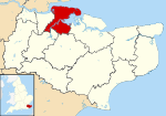
Geography Status: Unitary, Borough Region: South East England Ceremonial County: Kent Area:
- TotalRanked 170th
192.03 km² (74.5 mi²)Admin. HQ: Gun Warf, Chatham, Kent ONS code: 00LC Demographics Population:
- Total (2010 est.)
- DensityRanked 47th
256,700
1337 / km²Ethnicity:[1] 92.6% White
3.5% S.Asian
1.4% Black
1.4% Mixed
1.0% Chinese or otherPolitics Medway Council
http://www.medway.gov.uk/Leadership: Leader & Cabinet Executive: Conservative MPs: Mark Reckless (C)
Tracey Crouch (C)
Rehman Chishti (C)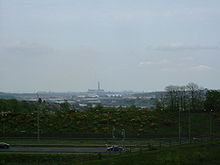 A view from Merrall's Shaw, Cuxton ENE over the Medway Towns. In sight are the M2, Rochester Bridge and Castle, the covered slips at Chatham Dockyard, Kingsnorth Power station and in the far distance the Grain Power Stations.
Medway is a conurbation and unitary authority in South East England. The Unitary Authority was formed in 1998 when the City of Rochester-upon-Medway amalgamated with Gillingham Borough Council and part of Kent County Council to form Medway Council, a unitary authority independent of Kent County Council, though still within the ceremonial county of Kent.[2]
It was colloquially known as The Medway Towns, however the city, villages and towns at the mouth of the River Medway have gradually merged. Over half of the unitary authority area is parished and rural in nature. Because of its strategic location by the major crossing of the River Medway, it has made a wide and historically significant contribution to Kent, and to England, dating back thousands of years, as evident in the siting of Watling Street by the Romans and by the Norman Rochester Castle, Rochester Cathedral (the second oldest in Britain), and the Chatham naval dockyard and its associated defences.
The main towns involved in the conurbation are (from west to east in terms of geographical position): Strood, Rochester, Chatham, Gillingham, and Rainham. Many smaller towns and villages such as Frindsbury, Brompton, Walderslade, Luton, Wigmore etc., lie within the conurbation. Outside the urban area the villages retain parish councils. Cuxton, Halling and Wouldham lie in the Medway Gap region to the south of Rochester and Strood. Hoo St Werburgh which hosts the Kingsnorth power station, Cliffe, High Halstow, Allhallows, Stoke and Grain lie on the Hoo Peninsula to the north. Frindsbury Extra including Upnor borders Strood.
Medway includes parts of the North Kent Marshes, an environmentally significant wetlands region with several Sites of Special Scientific Interest (SSSIs). Other similar areas of conservation include Ranscombe Farm on chalk grassland and woodland between Strood and Cuxton, with rare woodland flowers and orchids.
Medway is one of the boroughs included in the Thames Gateway development scheme. It is also the home of Universities at Medway, a tri-partite collaboration of the University of Greenwich, the University of Kent and Canterbury Christ Church University on a single campus in Chatham.
Contents
History
The Medway area has a long and varied history dominated originally by the city of Rochester and later by the naval and military establishments principally in Chatham and Gillingham.
Rochester was established by the Romans, who called it Durobrivae (meaning "stronghold by the bridge"), on an Iron Age site to control the point where Watling Street (now the A2) crossed the River Medway. The first cathedral was buillt by Bishop Justus in 604 and was rebuilt under the Normans by Bishop Gundulf, who also built the castle which stands opposite the cathedral. Rochester was also an important point for people travelling the Pilgrims' Way. Pilgrims' Way stretches from Winchester to the shrine of Thomas Becket at Canterbury. Pilgrims' Way crossed the Medway near Cuxton. Rochester became a walled town and under later Saxon influence a mint was established here.
Rochester has many fine buildings such as the Guildhall (today a museum) built in 1687, among the finest 17th-century civic buildings in Kent; the Corn Exchange, built in 1698, originally the Butcher's Market; the small Tudor house of Watts Charity endowed by Sir Richard Watts to house "six poor travelers" for one night each; Satis House and Old Hall, both visited by Queen Elizabeth I, built in 1573. In Medway there are 82 scheduled ancient monuments, 832 Listed buildings and 22 conservation areas. Parts of the Roman city wall are still in evidence.
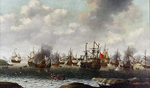 Dutch Attack on the Medway, June 1667 by Pieter Cornelisz van Soest, painted c. 1667. The captured ship HMS Royal Charles is right of centre
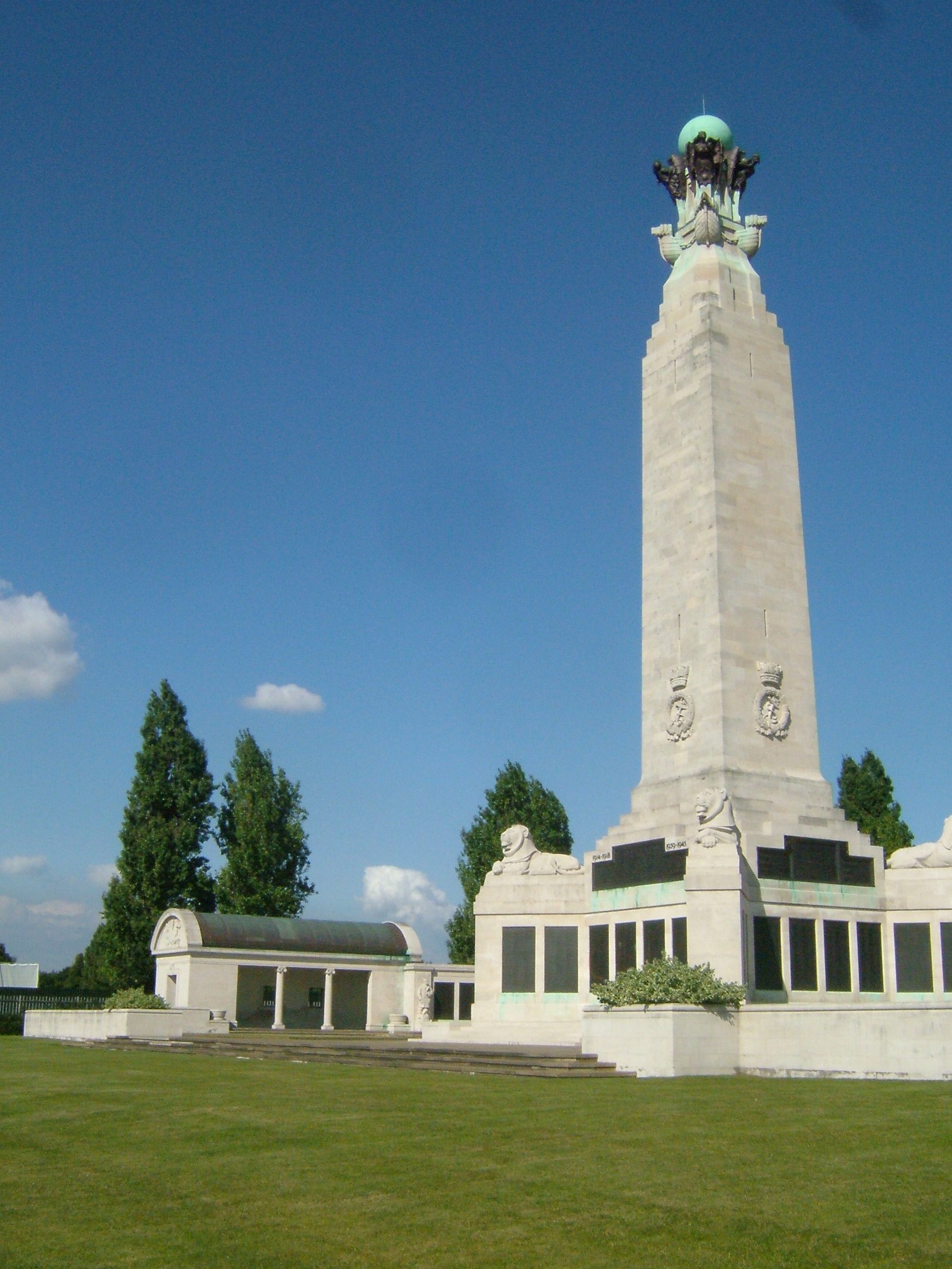
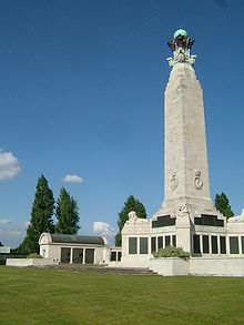 The Chatham naval memorial commemorates the 18,500 officers, ranks and ratings of the Royal Navy who were lost or buried at sea in the two World Wars. It stands on the Great Lines between Chatham and Gillingham.
The Royal Navy opened a dockyard during the reign of Henry VIII; it shut in 1984. It was protected by a series of forts including Fort Amherst and the Chatham Lines, Fort Pitt and Fort Borstal. The majority of surviving buildings in the Historic Dockyard are Georgian. It was here that Britain's most famous wooden warship HMS Victory, Admiral Nelson's flagship at Trafalgar, was built and launched in 1765[citation needed]. Sir Francis Drake learned his seamanship on the Medway; Sir John Hawkins founded a hospital in Chatham for seamen, and Nelson began his Navy service at Chatham at the age of 12. The river was further protected by such fortifications as Upnor Castle which, in 1667 in varying accounts says it was partly successful in thwarting the Dutch raid on the dockyard, or the commanding officer fled without firing on the Dutch.
Another warship built at Chatham that still exists is HMS Unicorn (a 46-gun "Leda" class frigate) laid down in February 1822, and launched 30 March 1824. She never saw active service and has been restored and is (as of 2005) preserved afloat in Dundee, Scotland.
There have also been other naval disasters in Medway other than the Raid on the Medway.
On 25 November 1914 the battleship HMS Bulwark was moored at buoy number 17 at Kethole Reach on the River Medway. She was taking on coal from the airship base at Kingsnorth, on the Isle of Grain when an internal explosion (most likely the result of cordite charges stored alongside a boiler room bulkhead and failure to follow guidelines on the storage of shells) ripped the ship apart. In all, the explosion killed 745 men and 51 officers. Five of the 14 men who survived died later of their wounds, and almost all of the others were seriously wounded. There are mass and individual graves in Woodlands Cemetery in Gillingham for the Bulwark's dead, who were mostly drawn from the Portsmouth area. The explosion could be heard from up to 20 miles at Southend and Whitstable. In terms of loss of life it remains the second worst explosion in British history.
Less than six months later there was a second explosion. This time it was the Princess Irene. She was a 1,500-passenger liner built at Dumbarton in 1914 for Canadian Pacific. Before she could leave Britain she was commandeered for war service and became HMS Princess Irene, and was used as a minelayer. After several trips she was back in the Medway for a refit when on the morning of 27 May 1915 another huge internal explosion tore through the vessel, shaking the ground for miles around and showering the surrounding villages with remains of bodies and debris. 278 died, including 78 workers from nearby towns and villages. In one Sheerness street there were ten who died. Once again sabotage was suspected, but it would seem that the mine charges were unstable and awaiting replacement.
For a complete history of the dockyard, including its closure in 1984, see Chatham Dockyard
The British Army also established barracks here; and the Royal Engineers headquarters is in Gillingham.
The Royal Marines also have a long association with Chatham. The Chatham Division was based in Chatham until the closure of the Dockyard. A small museum dedicated to the Royal Marines can be found at the dockyard.
Future development
Medway is expected to grow to have a population of 278,000 by 2020. Central government has worked with Medway Council and private enterprise to regenerate Medway with a total investment of over £1 billion over a 20 year period. Some of the projects include:
Medway Waterfront
The Medway Waterfront Renaissance Strategy is a 20-year plan for the redevelopment of up to seven miles (11 km) of waterfront along the River Medway. This project will create 6,000 to 8,000 homes and 8,500 jobs. There are five main areas designated for development:
Gillingham centre
Gillingham has got another 150 parking spaces, as well as a new town square within a new shopping area, a new cultural and leisure venue, improved connections and use of the Great Lines and Medway Park open spaces, plus improved pedestrian facilities.
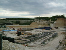
Rochester riverside
In Rochester, a 74-acre (30-hectare) brownfield site between the river and the railway line is being developed with high-quality high-density housing. Up to 50 homes per hectare will be built. The site will also include a Primary School, two hotels, business centre, health centre, cafes, restaurants and bars and various commerical units. [3] The site has accommodated a wide variety of industrial, commercial and maritime activities since the beginning of the 19th century but has become largely disused in recent years. Acorn Shipyard will be incorporated into the scheme.
Chatham centre and waterfront
Chatham town centre is the main commercial centre of Medway but has notorious traffic problems and much of the transport system will be redeveloped. In the early autumn of 2006 the "one way" system was turned into a two way system. In early 2009 the Sir John Hawkins flyover was demolished. The council believes that this will open up Chatham Waterfront [4] an area long marked for redevelopment though there is debate as to the new road system actually harming some businesses in Chatham. Chatham Waterfront is the area between Rochester railway station and Chatham Dockyard — numerous residential and commercial developments are planned in this area including two 20 story residential towers designed by architect Ken Yeang.
Strood riverside
Redevelopment including new homes and a landscaped play area were completed in the 1990s but now there are plans to extend this further along the river past Strood railway station. Another 500 to 600 homes will be built, and the waterfront will be developed with new recreational and leisure facilities (although there has been little to no provision for the subsequent increase in demand for medical, police, or educational services), improved open public space, better access to the railway station, the town centre and the Medway City Estate industrial area.
Temple Waterfront
This 70-hectare area (formerly a Templar farm) — between the river and Morgan's Timber yard in Strood — is commonly known as "Morgans" or "Morgan's field" and is often used illegally by off-road motorcyclists. Under the plans, 600 homes will be built along with 15,000 square metres of commercial space and a new two-hectare site for Morgan's Timber, however there has been little to no provision for the subsequent increase in demand for local public services.
Medway Gate
 A view of the Medway Gate development, April 2007.
This is not under the Medway waterfront scheme, but it is a major development under way in Strood between Medway Valley Park and junction 2 of the M2 motorway. Much of the development is inside a large unused chalk pit and requires massive landscaping efforts to make building possible. A small field which was hidden from the main road has also been landscaped. Many problems such as new schools and amenities to accommodate the new homes seem to be still unresolved.
Medway unitary authority
Medway Council Type Type Unicameral Leadership Leader of the Council Rodney Chambers Mayor Ted Baker Members 55 Political groups Conservative (35)
Labour (15)
Lib Dem (3)
Independent (2)Voting system First past the post Meeting place Chatham, Medway Website www.medway.gov.uk/default.aspx Formation
Throughout the 19th century there had been proposals to join the Medway towns under a single authority. By 1903 moves began to take place: that year saw the creation of the Borough of Gillingham, to which, in 1928, the adjoining parish of Rainham was added.
In 1944 a Medway Towns Joint Amalgamation Committee was formed by the borough corporations of Chatham, Gillingham and Rochester, to discuss the possibility of the towns forming a single county borough. In 1948 the Local Government Boundary Commission recommended that the area become a "most purposes" county borough, but the recommendation was not carried out. In 1956 the Joint Amalgamation Committee decided in favour of the amalgamation and invited representatives from Strood Rural District Council to join the Committee.[5] In 1960 a proposal was made by Rochester Council that the merger be effected by the city absorbing the two other towns, in order to safeguard its ancient charters and city status. This led to Gillingham Council voting to leave the committee, as it believed the three towns should go forward as equal partners.[6] On March 9 the committee held its last meeting, with the Chatham representatives voting to dissolve the body and those from Rochester voting against. The motion to disband was passed on the casting vote of the chairman, Alderman Semple from Chatham.[7]
Under the Local Government Act 1972, on 1 April 1974 the City of Rochester, the Borough of Chatham and part of Strood Rural District were amalgamated to form the Borough of Medway, a local government district in the county of Kent. Gillingham chose to remain separate. Under letters patent the former city council area was to continue to be styled the "City of Rochester" to "perpetuate the ancient name" and to recall "the long history and proud heritage of the said city".[8] The city was unique, as it had no council or charter trustees and no mayor or civic head. In 1979, the Borough of Medway was renamed as Rochester-upon-Medway, and in 1982 further letters patent transferred the city status to the entire borough.[9]
On 1 April 1998, the existing local government districts of Rochester-upon-Medway and Gillingham were abolished under the local government review and merged to become the new unitary authority of Medway, administratively independent from Kent. Since it was the local government district of Rochester-upon-Medway that officially held city status under the 1982 letters patent, when it was abolished, it also ceased to be a city. The other local government districts with city status that were abolished around this time (Bath and Hereford) appointed charter trustees to maintain the existence of the city and the mayoralty. However, Rochester-upon-Medway City Council had decided not to and as a result their city status was rescinded. Medway Council apparently only became aware of this when they discovered that Rochester was not on the Lord Chancellor's Office's list of cities.[10][11] Medway applied for city status in the 2000 and 2002 competitions, but was unsuccessful. In 2010, it started to refer to the "City of Medway" in promotional material, but it was rebuked and instructed not to do so in future by the Advertising Standards Authority.[12] Medway Council intends to bid for city status again in 2012.[13]
Current makeup
The council currently comprises 55 councillors representing different wards. The current political make-up of the Council (after the 2011 local elections) is;
- Conservative - 35
- Labour - 15
- Liberal Democrat - 3
- Independent - 2
Parts of the unitary authority are parished, chiefly the rural areas. There are currently 11 parishes;
- Allhallows
- Cliffe and Cliffe Woods
- Cooling
- Cuxton
- Frindsbury Extra
- Halling
- High Halstow
- Hoo St Werburgh
- St James Isle of Grain
- St Mary Hoo
- Stoke
Demographics
- Population: the population of Medway as measured in the 2001 Census was 249,488, of which 49% are male and 51% female. Most of the population live in the Chatham and Gillingham areas: 70,540 in Chatham and 99,773 in Gillingham.
- Unemployment: The closure of Chatham Dockyard cost some 20,000 jobs. In June 2005 local unemployment stood at 2.3% of the workforce, a total of 3,678 people. Many of the employed population of 160,000 people now work outside the district — especially in London, which has many transport links from Medway.
Economy
This is a chart of trend of regional gross value added of Medway at current basic prices published (pp. 240–253) by Office for National Statistics with figures in millions of pounds Sterling.
Year Regional Gross Value Added[note 1] Agriculture[note 2] Industry[note 3] Services[note 4] 1995 1,823 21 560 1,243 2000 2,348 8 745 1,595 2003 2,671 10 802 1,859 Transport
Roadways
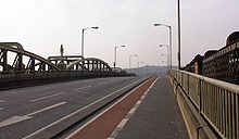 The A2 crossing the Medway at Rochester on the site of the Roman crossings, the medieval crossing was to the south
Watling Street (the A2), the Roman road between the Channel port of Dover and London, runs through Medway. This route became particularly congested and led to the building of the M2 to bypass the Medway Towns to the south in the 1960s and was subsequently widened extensively at the turn of the 21st century. The A2 through the Medway Towns varies from single carriageway to dual carriageway to "one way" systems. In places it deviates from the original route of Watling Street.
The A2 leaves the main route (which bypasses Medway by either the Northern Relief Road — The A289 or the M2) at the Three Crutches junction. The road descends through Strood towards the river. During the descent, the road to Gravesend, the A226 joins. In Strood the High Street is bypassed by the one-way system to the north and south encircling the High Street. The A2 crosses the Medway via two bridges in a dual carriageway (see Rochester Bridge). One bridge is Victorian and in the position of the original Roman bridge. The second bridge is more recent and build upon the piers of the original LCDR main line railway bridge (the Chatham Main Line uses the SER's branch line's bridge). In Rochester the High street is bypassed to the north by the dualled Corporation Street. The A2 then crosses the high street, climbs Star Hill and follows New road by Fort Pitt / Jackson's Field to bypass Chatham to the south (by the Station, via a flyover known as New Cut). As it approaches Luton it is a dual carriageway for a short stretch, where a major junction lies with the railway (Chatham Main line) passes overhead — this is known as Luton Arches. It then climbs Chatham Hill (to Gillingham) now has a separate bus lane. The A2 / Watling street traditionally bypasses central Gillingham which lies to the North. From the main road to Gillingham (Canterbury Street), the A2 is dual carriageway. Here the Northern Relief Road (A289) rejoins at the Will Adams roundabout. This is swiftly followed by the Bowater roundabout where the A278 Hoath Way leads to the M2 to the South, this is so named and distinctive because of the former paper mill Bowaters at this location that left a giant water tower. A large Tesco supermarket currently inhabits the site. As the road progresses into Rainham it becomes single carriageway again.
Connecting Medway with neighbouring Gravesend is the A226. The leaves the A2 on the hill above Strood. It is a single carriageway A road.
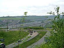 Junction Two of the M2 is on the A228, just before the Medway motorway bridge. Along side is High Speed 1. Both are seen climbing up the Nashenden Valley, towards Bluebell Hill.
The A228 runs along the west bank of the Medway, through Strood. Intersecting the M2 at its second junction, crossing the A2 through the centre of Strood and meeting (and encompassing for a short stretch) the Northern Relief Road (A289). The road then carries on to the Isle of Grain. Throughout its passage through Strood it is single carriageway, but the stretches to the North are dualled partially toward Grain. The road to Grain was an accident black spot, this and increased traffic from the major port of Thamesport which is located to the north-west along the Medway Estuary prompted the construction of a new dual carriageway. The A228 Main Road to Ropers Lane project was provisionally approved by the government in December 2001. Design work started in March 2000 and in February 2004, contractors got under way with moving services such as water, gas and fuel pipes. This work was vital, as the pipes actually supply the Hoo Peninsula and the power station at Grain. The largest water main that was moved was 24 inches (610 mm) in diameter and the largest gas main 36 inches (914 mm). The road cost £19 million and is approximately 2.5 miles (4 km) long.
The A229 starts from the A2 at the junction at the top of Star Hill alongside Jackson's Field / Fort Pitt, it follows City Way to the South where at Fort Horstead / Rochester Airport / Mid Kent College it meets the branch from Chatham (the A230 which starts at Chatham Station / New Cut). From here it continues south, becoming dual carriageway and meeting the M2 at its third junction, which also provides access with Walderslade. This road then proceeds down Blue Bell Hill (from the summit of the North Downs) to the county town of Maidstone and the M20.
The A278 Hoath Way links the A2 at Gillingham to its southern suburbs (Hempstead, Wigmore and Parkwood) to the M2's fourth junction. It is dual carriageway throughout.
The A289 was built in the 1990s as the Medway Towns Northern Relief Road. Constructed in three stages, firstly it bypasses Strood with a dual carriageway from Three Crutches (M2 J1) to the A226 and the A228 (The Wainscott Northern Bypass). It then joins the A228 (as The Wainscott Eastern Bypass) — these two part are dualled. A dualled link road leads to the Medway Tunnel to the Chatham Dockyard. Here it meets Dock Road (A231) that leads to Chatham. The A289 continues between northern Gillingham and the river, and then turns southwards through Gillingham Golf Course to rejoin the A2 at the Will Adams roundabout.
The A2045 is the A289's counterpart, however it is largely unbuilt. The Medway Towns Southern Relief Road was proposed to link the (then) new developments to the south of Chatham (Walderslade) and Gillingham (Hempstead, Wigmore and Parkwood) with M2's J3 and the A229 to the east and the M2's J4 and A278 in the west. A single carriageway road was built south of Walderslade to access the Walderslade Woods and Lordswood developments. At the other end a small section was built to access the Hempstead development and its shopping centre. However, the key middle stretch was left unbuilt, a link road to central Chatham via Luton, the B2156 North Dane Way was also left incomplete with no road to link to. The removal of Medway from Kent (which the incomplete section would lay in) and the recent widening of M2 leaves the proposed project with little chance of completion in the foreseeable future.
Bus
The vast majority of local bus routes throughout Medway are centred upon the Pentagon bus station in Chatham, located at the Pentagon Shopping Centre. Most bus routes are run by Arriva Southern Counties, which took over the locally-owned Maidstone and District bus company in the 1990s. Other local bus companies including Nu-Venture provide certain services, some under contract to the local authority. A Saturdays 'park & ride' service is run from a car park constructed on Rochester Airport to Chatham/Rochester on behalf of Medway Council.
Bus links to London and other parts of the south east can be achieved via Bluewater shopping centre, near Greenhithe, which has extensive bus routes to London. Commuter coaches runs from various parts of Medway to a selection of London destinations using the M2/A2. Operating companies include The Kings Ferry and Chalkwell.
Railways
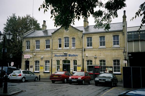
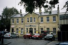 Rochester station building. The railway passes at first floor level on a viaduct.
See also
- Strood Station
- Rochester Station
- Chatham Station
- Gillingham Station
- Rainham Station
- Cuxton Station
- Halling Station
The Medway Council area has seven rail stations. It is served by the Medway Valley Line, the North Kent Line and the Chatham Main Line.
The owners of the Thames and Medway Canal tunnel that linked Medway (specifically Strood) with Gravesend turned half their canal into a railway bringing the first rails to Medway. They were soon absorbed by the South Eastern Railway whose North Kent Line linked Strood with Gravesend, Dartford, and then London (London Bridge). Subsequently SER extended their branch from their main line to Maidstone to Strood — the Medway Valley Line. Stations were built on the Medway Valley line for the villages of Cuxton and Halling.
A rival company, the London, Chatham and Dover Railway, built a railway between Chatham and East Kent. Unable to secure a connection and running rights over the SER's North Kent line they built their own main line to Bromley where they connected with the West End of London & Crystal Palace Railway to gain access to London Victoria. This railway became known as the Chatham Main Line. It had stations at Rochester Bridge which was actually in Strood, Chatham and New Brompton which was renamed Gillingham. The line was extended through Rainham to the Kent Coast (Thanet and Dover).
In reaction to this strong rival the SER built a small branch alongside the LCDR over the Medway on a parallel bridge to Rochester and built a terminus called Chatham although it failed to reach Chatham.
The strenuous competition between the two companies resulted in their merger into the South Eastern and Chatham Railway in 1899. Subsequent rationalisation saw the closure of the LCDR's station in Strood and the SER's branch to Rochester and Chatham (although the bridge was retained and is used to this day).
Post World War I saw the big four grouping and the SECR was merged into Southern in 1923. This led to electrification of suburban services (750v DC third rail) which by World War II had seen electric traction reach Gillingham on the Chatham Main Line and Maidstone West (via Strood and the North Kent Line) on the Medway Valley Line.
Post war (1948) saw nationalisation into British Rail, which under its 1955 modernisation part saw the completion of Southern's electrification efforts in Kent as a key target. Thus Rainham was reached as part of this programme. It also saw the extension of platforms on the Chatham Main Line to 12 cars, leading to the closure of two of Chatham's four platforms. Rochester retained four platforms, while Strood and Gillingham kept three. Rainham has only had two platforms.
Extensive goods yards existed at Strood, Rochester and Gillingham. Strood had engine sheds, while Gillingham still has carriage depots. A freight branch to Chatham Dockyard also exists. The network within the dockyard has been extensively curtailed since the dockyards closure.
Rail services generally consist of North Kent Line services (to London Bridge and beyond — Charing Cross and Cannon Street) starting from Gillingham. The Medway Valley line receives a shuttle service up and down terminating at Strood for transfers to the North Kent Line, although some services run through to Tonbridge and even Gatwick. The main services are on the Chatham Main line, with stopper services from Faversham (i.e. they stop at local stations, running fast from Bromley) and fast services from Kent Coast (i.e. they run fast from Medway to London). Services are currently operated by Southeastern.
The High Speed 1 Channel Tunnel Rail Link passes through the Medway Towns area, running parallel to the M2/A2 Trunk road.The completion of High Speed 1 has seen domestic services operating on the rail link , which includes a stopping service starting at Faversham running to Strood and Gravesend before joining the High Speed line at Ebbsfleet. From there it travels at high speed to Stratford International and St. Pancras International, where connections can now be made with mainline trains to the north of England. The rail service is extensively used by the residents of Medway to commute into London.
Waterways
The River Medway is not used for local transport purposes (it is extensively used for leisure) however cargo ships still sail to the cement works to the south at Halling/Cuxton, by Union Transport of Bromley. Part of the closed Royal Navy base is now used as a cargo port, with facilities of Ro/Ro, cargo that comes in ranges from paper pulp to dredged material but this only occupies one of the three main basins. There is also a ship repair located in the basin. Thamesport handles the shipping of containers and fossil fuels, located on the edge of the Medway Estuary on the Isle of Grain. Kingsnorth Power Station has coal shipped in from Dunkirk, also Scotline who operate a fleet of coasters for the import of wood have a wharf on the River Medway. There is also a wharf on the river called Eurowharf which deals with dredged material. In addition, there is a shipping company based on the river, formerly known as Lapthorn Shipping and now as Coastal Bulk Shipping. Coastal Bulk Shipping ceased trading at the end of 2008.
Air
There are two small airports, Rochester Airport, but this is a "grass strip" and used for leisure purposes and Stoke Airfield near Grain which is used by microlights and light aircraft. For air travel, Medway residents must use Kent's main airports Kent International (Manston) or Lydd but these lack extensive passenger facilities or routes, thus the London airports are used the vast majority of the time (mainly Gatwick, Heathrow, Luton and Stansted)
Leisure and recreation
- Medway Park (formerly The Black Lion Leisure Centre) in Gillingham is a sub-regional sports centre with three indoor pools for swimming and SCUBA diving, gym, fitness centre, sports hall and squash courts. It includes the Jumpers Rebound Centre for trampolining. Medway Park has been upgraded for the Medway 2012 programme to secure local benefits from the London Olympics.
- The Strand Leisure Park in Gillingham has an open-air swimming pool on the banks of the River Medway as well as other leisure attractions including tennis courts and a narrow-gauge railway.
- Strood Sports Centre in has an indoor swimming pool, gym, sports hall, squash courts and an astroturf sports pitch.
- Gillingham has an ice rink, The Ice Bowl.
- Gillingham F.C. is the main football team of the area. They play in Football League Two.
- John Nike Ski Centre - located in Capstone near Hempstead
- The Splashes Leisure Centre in Rainham, Kent has a swimming pool with indoor slide and a wave machine. It also has a small gym on the second floor.
Famous people
See sections in the constituent towns.
- William Adams, the first Englishman to record reaching Japan, was born in Gillingham. The Japanese Shogun made him a samurai (warrior), he is significant to Medway because this has led to the twinning with Yokosuka and Ito.
- Charles Dickens lived in Medway, a museum was in Eastgate House in Rochester until its closure in 2004. A visitor attraction based on his works, is found at Chatham Dockside. One of his many houses still exists in Rochester High Street today.
Twin towns
 — Valenciennes (France) (existing since 1955 making it the 2nd oldest such twinning in the UK)
 — Yokosuka and Itō (Japan)
 — Cádiz (Spain)
References
- ^ Neighbourhood Statistics. "Check Browser Settings". Neighbourhood.statistics.gov.uk. http://www.neighbourhood.statistics.gov.uk/dissemination/LeadTableView.do?a=3&b=276846&c=medway&d=13&e=13&g=406944&i=1001x1003x1004&m=0&r=1&s=1207137037477&enc=1&dsFamilyId=1812. Retrieved 2011-08-19.
- ^ [1][dead link]
- ^ http://www.medway.gov.uk/pdf/rochester_riverside_brochure-3.pdf
- ^ http://www.medway.gov.uk/business/medwayregeneration/keyregenerationaims/chathamfuture.aspx
- ^ "Medway Towns Amalgamation — Favoured by three councils", The Times, November 6, 1956
- ^ "Gillingham leaving merger scheme", The Times, February 3, 1960
- ^ "Medway Towns split over merger — Committee disbands", The Times, March 10, 1960
- ^ London Gazette: no. 46243. p. 3651. 21 March 1974. Retrieved 2008-05-30. Letters Patent dated 18 March 1974, text also available from Medway Council archives website
- ^ London Gazette: no. 48875. p. 1173. 28 January 1982. Retrieved 2008-05-30.Publishing Letters Patent dated 25 January 1982, text also available from Medway Council archives website
- ^ "Error costs Rochester city status", BBC news, Thursday, 16 May 2002.
- ^ Medway Council – Regeneration and Community Overview and Scrutiny Committee, Report on Rochester City Status[dead link], 4 March 2003.
- ^ "ASA Adjudication on Medway Council". Asa.org.uk. 2011-03-16. http://www.asa.org.uk/ASA-action/Adjudications/2011/3/Medway-Council/TF_ADJ_49924.aspx. Retrieved 2011-08-19.
- ^ "Medway Council in Kent makes bid for 2012 city status". BBC News. 2010-03-24. http://news.bbc.co.uk/1/hi/england/kent/8585429.stm. Retrieved 2011-08-19.
- ^ Medway Council - Twin towns[dead link]
External links
- Medway Council
- Archive Images
- Bob Marshall-Andrews MP
- Detailed history of the Medway Towns
- Chatham's World Heritage Site application
- Medway Music scene site past and present
- User forum regarding services at Hoo Marina
Towns and villages in the Unitary authority of Medway in Kent, England Allhallows · Borstal · Brompton · Chatham · Chattenden · Cliffe · Cliffe Woods · Cooling · Cuxton · Frindsbury · Frindsbury Extra · Gillingham · Halling · Hempstead · High Halstow · Hoo St Werburgh · Isle of Grain · Lordswood · Rochester · Rainham · Rainham Mark · St Mary Hoo · St Mary's Island · Stoke · Strood · Twydall · Upnor · Wainscott · Walderslade · WigmoreCeremonial county of Kent Unitary authorities Borough of MedwayBoroughs or districts Major settlements - Ashford
- Broadstairs
- Canterbury
- Chatham
- Cranbrook
- Dartford
- Deal
- Dover
- Edenbridge
- Faversham
- Folkestone
- Fordwich
- Gillingham
- Gravesend
- Greenhithe
- Herne Bay
- Hythe
- Lydd
- Maidstone
- Margate
- Minster
- New Romney
- Northfleet
- Paddock Wood
- Queenborough
- Rainham
- Ramsgate
- Rochester
- Royal Tunbridge Wells
- Sandwich
- Sevenoaks
- Sheerness
- Sittingbourne
- Snodland
- Southborough
- Strood
- Swanley
- Swanscombe
- Tenterden
- Tonbridge
- Walmer
- West Malling
- Westerham
- Westgate-on-Sea
- Whitstable
See also: List of civil parishes in Kent
Rivers See: Rivers of KentTopics  Districts of South East England
Berkshire 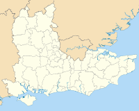
Buckinghamshire Aylesbury Vale • Chiltern • Milton Keynes • South Bucks • Wycombe
East Sussex Brighton and Hove • Eastbourne • Hastings • Lewes • Rother • Wealden
Hampshire Basingstoke and Deane • East Hampshire • Eastleigh • Fareham • Gosport • Hart • Havant • New Forest • Portsmouth • Rushmoor • Southampton • Test Valley • Winchester
Isle of Wight Kent Ashford • Canterbury • Dartford • Dover • Gravesham • Maidstone • Medway • Sevenoaks • Shepway • Swale • Thanet • Tonbridge and Malling • Tunbridge Wells
Oxfordshire Surrey Elmbridge • Epsom and Ewell • Guildford • Mole Valley • Reigate and Banstead • Runnymede • Spelthorne • Surrey Heath • Tandridge • Waverley • Woking
West Sussex Adur • Arun • Chichester • Crawley • Horsham • Mid Sussex • Worthing
London commuter belt Home Counties Bedfordshire • Berkshire • Buckinghamshire • Cambridgeshire • City of London • Dorset • Essex • Greater London • Hampshire • Hertfordshire • Kent • Middlesex • Oxfordshire • Surrey • Sussex
Urban Areas Greater London Urban Area • Reading/Wokingham Urban Area • Southend Urban Area • Aldershot Urban Area • Luton/Dunstable Urban Area • High Wycombe Urban Area • Medway Towns Urban Area • Aylesbury Urban AreaLondon boroughs Barking and Dagenham • Barnet • Bexley • Brent • Bromley • Camden • Croydon • Ealing • Enfield • Greenwich • Hackney • Hammersmith and Fulham • Haringey • Harrow • Havering • Hillingdon • Hounslow • Islington • Kensington and Chelsea • Kingston upon Thames • Lambeth • Lewisham • Merton • Newham • Redbridge • Richmond upon Thames • Southwark • Sutton • Tower Hamlets • Waltham Forest • Wandsworth • WestminsterCities and towns
(100k+)Towns
(25k-99k)Ashford, Surrey • Aylesbury • Basildon • Basingstoke • Billericay • Bishop's Stortford • Borehamwood • Bracknell • Brentwood • Burgess Hill • Camberley • Canvey • Cheshunt • Dartford • Epsom • Ewell • Dunstable • Earley • Farnham • Fleet • Guildford • Gravesend • Grays • Harlow • Harpenden • Hatfield • Hemel Hempstead • Horsham • Hitchin • Letchworth • Loughton • Maidenhead • Maidstone • Rayleigh, Essex • Redhill • Royal Tunbridge Wells • Sittingbourne • St Albans • Stevenage • Sunbury-on-Thames • Tonbridge • Ware • Watford • Welwyn Garden City • Wickford • Windsor • Woking • Wokingham • WoodleyTowns
(10k-25k)Addlestone • Amersham • Ashtead • Beaconsfield • Berkhamsted • Broxbourne • Buckhurst Hill • Bushey • Chertsey • Chesham • Chigwell • Croxley Green • Dorking • East Grinstead • East Malling • Englefield Green • Epping • Godalming • Hadleigh • Haywards Heath • Hertford • Hoddesdon • Horley • Houghton Regis • Knaphill • Marlow • Potters Bar • Reigate • Rickmansworth • Sandhurst • Sevenoaks • Snodland • Shepperton • Southborough, Kent • Staines • Stanwell • Swanley • Thundersley • Tilbury • Tring • Waltham Abbey • Waltham CrossCategories:- Medway
- Local government in Kent
- Unitary authorities of England
- Urban areas of England
- Local authorities adjoining the River Thames
- Local government districts of South East England


Wikimedia Foundation. 2010.