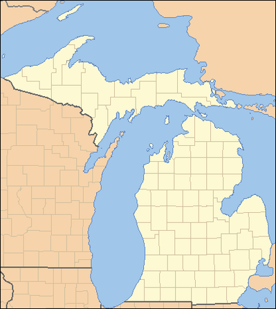
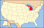
- List of counties in Michigan
-
 GE
GEThere are 83 counties in the U.S. state of Michigan. The boundaries of these counties have not changed substantially since 1897. However, throughout the 19th century, the state legislature frequently adjusted county boundaries. County creation was intended to fulfill the goal of establishing government over unorganized territory, but a more important goal was encouraging settlement by surveying the land and dividing it into saleable sections.
The creation of counties generally occurred in two stages. First the boundaries of a county were declared and given a name. The county appeared on maps, even though this may have been the entire extent of a county's tangible existence for several years. During this period, the as yet unorganized county was attached to another already organized county for administrative purposes. The legislature frequently changed the administrative attachment of these unorganized counties. Residents of such an attached county could petition the legislature for organization, which was the granting of full legal recognition to the county.
There are many cities and villages that span county boundaries in Michigan, including its capital, Lansing. For a few years during the early 1970s, split cities briefly had authority to petition to change the county boundaries to accord with the city boundaries. The only city to take advantage of this brief opportunity was New Baltimore (previously split between Macomb County and St. Clair County; now completely in Macomb). This transfer of territory from St. Clair to Macomb was the only county boundary change in Michigan since the early 20th century.
The state Constitution of 1850 permitted an incorporated city with a population of at least 20,000 to be organized into a separate county of its own.[1] The Constitution of 1908 retained this provision, but raised the population threshold to 100,000.[2] No city was ever organized into an independent county in this fashion and when a new Constitution took effect in 1963, the provision was removed.
Contents
Etymologies
The origin of some names is unclear and credible scholarly sources disagree on the meaning (or intended meaning).
The wholesale renaming of Michigan counties in the early 19th Century made several cultural and political points.
Nine counties have names invented by Henry Schoolcraft, usually adapted from parts of Native American words, but sometimes having parts from Greek, Arabic and Latin roots.[3]
Henry Schoolcraft's made up words have disputed sources. While he was a devotée of Native American words and culture, some of his words may have originated with tribes from other areas of the country, such as New York or the northeast, where many settlers to Michigan came from. Real Native American words were eradicated,and he substituted made-up pseudo words, sometimes with a kernel of Indian language or sound in them.[4][5][6]
A second group of four counties were renamed for Irish locales, apparently because it was close to the heart for certain Michigan legislators or their constituents.
Ten counties, the so-called cabinet counties, were named for persons who served in Andrew Jackson's presidential administration, which was tied to Michigan's anticipated ascendancy to statehood. Eight were named in 1829. Livingston County was named in 1833. Cass County was also named in 1829, but Governor Lewis Cass did not become a member of Jackson's Cabinet until 1831.[3][4][7]
List of counties
County FIPS Code[8] County Seat Created Origin Etymology Population Area Map
Alcona County 001 Harrisville 1840 (boundaries declared)
1869 (organised)From unorganized territory. Was named Negwegon County until 1843. Pseudo-Native American name created by Henry Schoolcraft 10,942 1,791 sq mi
(4,639 km2)
Alger County 003 Munising 1885 From part of Schoolcraft County. Russell A. Alger, (1836-1907):
Governor of Michigan; Senator; and Secretary of War during the McKinley Administration9,601 5,049 sq mi
(13,077 km2)
Allegan County 005 Allegan 1831 (boundaries declared)
1835 (organised)From part of Barry County and unorganized territory. Pseudo-Native American name created by Henry Schoolcraft 111,408 1,833 sq mi
(4,747 km2)
Alpena County 007 Alpena 1840 (boundaries declared)
1857 (organized)From part of Mackinac County and unorganized territory. Was named Anamickee County until 1843. Pseudo-Native American name created by Henry Schoolcraft 29,598 1,695 sq mi
(4,390 km2)
Antrim County 009 Bellaire 1840 From part of Mackinac County. Was named Meegisee County until 1843. County Antrim, Ireland 23,598 602 sq mi
(1,559 km2)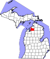
Arenac County 011 Standish 1831 From unorganized territory. Annexed to Bay County in 1857 and reinstated in 1883. Pseudo-Native American name created by Henry Schoolcraft 15,899 681 sq mi
(1,764 km2)
Baraga County 013 L'Anse 1875 From part of Houghton County. Frederic Baraga (1797-1868): Catholic missionary and first Bishop of the Diocese of Sault Ste. Marie 8,860 1,069 sq mi
(2,769 km2)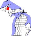
Barry County 015 Hastings 1829 From unorganized territory. William T. Barry (1784-1835): Postmaster General in the Jackson Administration 59,173 577 sq mi
(1,494 km2)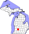
Bay County 017 Bay City 1857 From parts of Arenac County, Midland County and Saginaw County. Saginaw Bay 107,771 631 sq mi
(1,634 km2)
Benzie County 019 Beulah 1863 From part of Leelenau County. French: Riviere Aux-Bec-Scies 17,525 860 sq mi
(2,227 km2)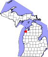
Berrien County 021 St. Joseph 1829 From unorganized territory. John M. Berrien (1781-1856): Attorney General in the Jackson Administration 156,813 1,581 sq mi
(4,095 km2)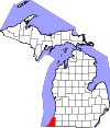
Branch County 023 Coldwater 1829 From unorganized territory. John Branch (1782-1863): Secretary of the Navy in the Jackson Administration 45,248 507 sq mi
(1,313 km2)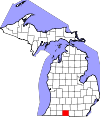
Calhoun County 025 Marshall 1829 From unorganized territory. John C. Calhoun (1782-1850): Vice President of the United States in the Jackson Administration 136,146 718 sq mi
(1,860 km2)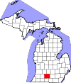
Cass County 027 Cassopolis 1829 From unorganized territory. Lewis Cass (1782-1866): Secretary of War in the Jackson Administration 52,293 508 sq mi
(1,316 km2)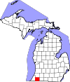
Charlevoix County 029 Charlevoix 1869 From parts of Antrim County, Emmet County and Otsego County. Pierre François Xavier de Charlevoix (1682-1761): Jesuit traveller and historian of New France 25,949 1,391 sq mi
(3,603 km2)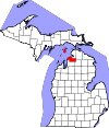
Cheboygan County 031 Cheboygan 1840 From part of Mackinac County. Cheboygan River 26,152 885 sq mi
(2,292 km2)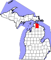
Chippewa County 033 Sault Ste. Marie 1827 From part of Mackinac County. Ojibwa Native American tribe, also known as the Chippewa 38,520 2,698 sq mi
(6,988 km2)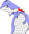
Clare County 035 Harrison 1840 From part of Mackinac County and unorganized territory. Was named Kaykakee County until 1843. County Clare, Ireland 30,926 575 sq mi
(1,489 km2)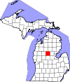
Clinton County 037 St. Johns 1831 From unorganized territory. DeWitt Clinton (1769-1828): Governor of New York. 75,382 575 sq mi
(1,489 km2)
Crawford County 039 Grayling 1840 From part of Mackinac County and unorganized territory. Was named Shawano County until 1843. William Crawford, (1732-82), American Revolutionary War colonel western surveyor 14,074 563 sq mi
(1,458 km2)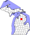
Delta County 041 Escanaba 1843 From part of Mackinac County and unorganized territory. Greek letter Delta, it refers to the triangular shape of the original county which included segments of Menominee, Dickinson, Iron and Marquette counties 37,069 1,992 sq mi
(5,159 km2)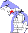
Dickinson County 043 Iron Mountain 1891 From parts of Iron County, Marquette County and Menominee County. Donald M. Dickinson (1846-1917): Postmaster General in the Cleveland Administration 26,168 777 sq mi
(2,012 km2)
Eaton County 045 Charlotte 1829 From unorganized territory. John Eaton (1790-1856): Secretary of War in the Jackson Administration 107,759 579 sq mi
(1,500 km2)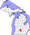
Emmet County 047 Petoskey 1840 From part of Mackinac County. Was named Tonegadana County until 1843. Robert Emmet (1778-1803): Irish nationalist and rebel leader 32,694 882 sq mi
(2,284 km2)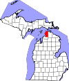
Genesee County 049 Flint 1835 From parts of Lapeer County, Saginaw County and Shiawassee County. Seneca word, "je-nis-hi-yeh," meaning "beautiful valley": named after western New York State valley from which many settlers came 425,790 649 sq mi
(1,681 km2)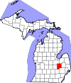
Gladwin County 051 Gladwin 1831 From unorganized territory. Major Henry Gladwin, British commander of the fort at Detroit during the siege by Chief Pontiac in 1763-64. 25,692 516 sq mi
(1,336 km2)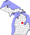
Gogebic County 053 Bessemer 1887 From part of Ontonagon County. Probably from the Chippewa "bic" which most references interpret as "rock." 16,427 1,476 sq mi
(3,823 km2)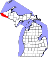
Grand Traverse County 055 Traverse City 1851 From part of Omeena County. French phrase "grande travers," which means "long crossing." It was given first to Grand Traverse Bay by French voyageurs. 86,986 601 sq mi
(1,557 km2)
Gratiot County 057 Ithaca 1831 From unorganized territory. Captain Charles Gratiot (1788-1855), built Fort Gratiot at the present site of Port Huron 42,476 572 sq mi
(1,481 km2)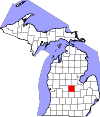
Hillsdale County 059 Hillsdale 1829 From unorganized territory. From its terrain, made up of hills and dales.[9] 46,688 607 sq mi
(1,572 km2)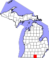
Houghton County 061 Houghton 1845 From parts of Marquette County and Ontonagon County. Dr. Douglass Houghton (1809-1845), first state geologist of Michigan, physician and surgeon, mayor of Detroit (1842-1843) 36,628 1,502 sq mi
(3,890 km2)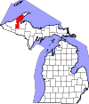
Huron County 063 Bad Axe 1840 From part of Sanilac County. Lake Huron. The French named "Lac des Hurons" for the Native American tribe they called "hure" (meaning "head") when they saw the fantastic way they dressed their hair. 33,118 2,136 sq mi
(5,532 km2)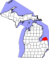
Ingham County 065 Mason 1829 (boundaries declared)
1838 (organised)From parts of Shiawassee County, Washtenaw County and unorganized territory. Samuel D. Ingham (1779-1860), U.S. Secretary of the Treasury in the Jackson Administration 280,895 561 sq mi
(1,453 km2)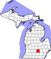
Ionia County 067 Ionia 1831 From part of Mackinac County and unorganized territory. Province in ancient Greece 63,905 580 sq mi
(1,502 km2)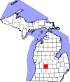
Iosco County 069 Tawas City 1840 From unorganized territory. Was named Kanotin County until 1843. Pseudo-Native American name created by Henry Schoolcraft 25,887 1,891 sq mi
(4,898 km2)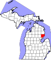
Iron County 071 Crystal Falls 1885 From parts of Marquette County and Menominee County. For the iron deposits and mines found in the county 11,817 1,211 sq mi
(3,136 km2)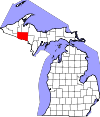
Isabella County 073 Mt. Pleasant 1831 From part of Mackinac County and unorganized territory. Queen Isabella I (1451-1504) of Spain, under whose patronage Columbus undertook his voyages. 70,311 578 sq mi
(1,497 km2)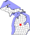
Jackson County 075 Jackson 1829 (boundaries declared)
1832 (organised)From part of Washtenaw County and unorganized territory. Andrew Jackson (1767-1845), 7th President of the United States and President when Michigan was admitted to the Union 160,248 724 sq mi
(1,875 km2)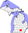
Kalamazoo County 077 Kalamazoo 1829 From unorganized territory. Named for the Kalamazoo River. See Etymology of Kalamazoo for a discussion of the river's name. 250,331 580 sq mi
(1,502 km2)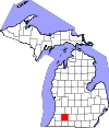
Kalkaska County 079 Kalkaska 1840 From part of Mackinac County. Was named Wabassee County until 1843. Pseudo-Native American name created by Henry Schoolcraft 17,153 571 sq mi
(1,479 km2)
Kent County 081 Grand Rapids 1831 From part of Mackinac County and unorganized territory. New York jurist James Kent, who represented the Michigan Territory in its dispute with Ohio over the Toledo Strip. 602,622 872 sq mi
(2,258 km2)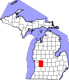
Keweenaw County 083 Eagle River 1861 From part of Houghton County. Ojibwe word gakiiwe-wewaning meaning portage 2,156 5,966 sq mi
(15,452 km2)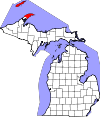
Lake County 085 Baldwin 1840 From part of Mackinac County. Was named Aischum County until 1843. Has several small lakes and lies near Lake Michigan 11,539 575 sq mi
(1,489 km2)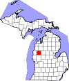
Lapeer County 087 Lapeer 1822 From parts of Oakland County and St. Clair County. An Americanization of the French la pierre meaning flint 88,319 663 sq mi
(1,717 km2)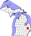
Leelanau County 089 Suttons Bay Township 1840 From part of Mackinac County. Pseudo-Native American name created by Henry Schoolcraft 21,708 2,532 sq mi
(6,558 km2)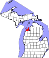
Lenawee County 091 Adrian 1822 From part of Monroe County. A Henry Schoolcraft neologism signifying a Native American word for man -- either from the Delaware "leno or lenno" or the Shawnee "lenawai" 99,892 761 sq mi
(1,971 km2)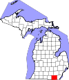
Livingston County 093 Howell 1833 (boundaries declared)
1836 (organised)From parts of Shiawassee County and Washtenaw County. Edward Livingston (1764-1836): second Secretary of State in the Andrew Jackson administration 180,967 585 sq mi
(1,515 km2)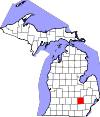
Luce County 095 Newberry 1887 From parts of Chippewa County and Mackinac County. Named for Michigan Governor Cyrus G. Luce 6,631 1,912 sq mi
(4,952 km2)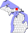
Mackinac County 097 St. Ignace 1818 From part of Wayne County. Was named Michilimackinac County until 1837. Was originally Michilimackinac, believed to be a French interpretation of the Native American name for the place 11,113 2,101 sq mi
(5,442 km2)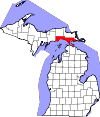
Macomb County 099 Mt. Clemens 1818 From part of Wayne County. Named for U.S. General Alexander Macomb, a notable officer of the War of 1812 840,978 570 sq mi
(1,476 km2)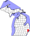
Manistee County 101 Manistee 1840 From part of Mackinac County. Named for the Manistee River, which in turn is from the Ojibwe name, ministigweyaa meaning (river) at whose mouth there are islands 24,733 1,281 sq mi
(3,318 km2)
Marquette County 103 Marquette 1843 From parts of Chippewa County and Mackinac County. Named for French Jesuit missionary Pere Jacques Marquette 67,077 3,425 sq mi
(8,871 km2)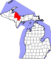
Mason County 105 Ludington 1840 From part of Mackinac County. Was named Notipekago County until 1843. Named for Michigan Governor Stevens T. Mason 28,705 1,242 sq mi
(3,217 km2)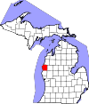
Mecosta County 107 Big Rapids 1840 From parts of Mackinac County and Oceana County. Named for Mecosta, a Native American leader 42,798 571 sq mi
(1,479 km2)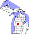
Menominee County 109 Menominee 1861 From part of Delta County. Was named Bleeker County until 1863. Named for the Menominee Native American people 24,029 1,338 sq mi
(3,465 km2)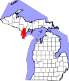
Midland County 111 Midland 1831 From part of Saginaw County and unorganized territory. Located near the geographical center of the Lower Peninsula 83,629 528 sq mi
(1,368 km2)
Missaukee County 113 Lake City 1840 From part of Mackinac County. Named for Missaukee, an Ottawa leader who signed land-grant treaties in 1831 and 1833 14,849 574 sq mi
(1,487 km2)
Monroe County 115 Monroe 1817 From part of Wayne County. Named for James Monroe, the fifth U.S. President 152,021 680 sq mi
(1,761 km2)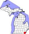
Montcalm County 117 Stanton 1831 From part of Mackinac County and unorganized territory. Named for the Marquis de Montcalm, a French military commander in Quebec 63,342 721 sq mi
(1,867 km2)
Montmorency County 119 Atlanta 1840 From part of Mackinac County and unorganized territory. Was named Cheonoquet County until 1843. House of Montmorency, influential in the history of French Canada 9,765 562 sq mi
(1,456 km2)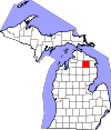
Muskegon County 121 Muskegon 1859 From parts of Oceana County and Ottawa County. Muskegon River running through county, from the Ojibwa/Chippewa word "mashkig" meaning "swamp" or "marsh." 172,188 1,459 sq mi
(3,779 km2)
Newaygo County 123 White Cloud 1840 From parts of Mackinac County and Oceana County. Named for a Chippewa leader who signed the Saginaw Treaty of 1819[10] 48,460 861 sq mi
(2,230 km2)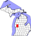
Oakland County 125 Pontiac 1819 (boundaries declared)
1820 (organized)From part of Macomb County. Named for the numerous "oak openings" in the county. Dr. Bela Hubbard, surveyor of Michigan, described an "oak opening" as "a majestic orchard of oaks and hickories varied by small prairies, grassy lawns and clear lakes." 1,202,362 908 sq mi
(2,352 km2)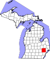
Oceana County 127 Hart 1831 From part of Mackinac County. Borders Lake Michigan, the fresh water "ocean." 26,570 1,307 sq mi
(3,385 km2)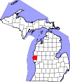
Ogemaw County 129 West Branch 1840 From unorganized territory. Annexed to Iosco County in 1867 and reinstated in 1873. Named for the Ojibwe word ogimaa, meaning chief or leader 21,699 575 sq mi
(1,489 km2)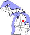
Ontonagon County 131 Ontonagon 1843 From parts of Chippewa County and Mackinac County. Named for the Ontonagon River, called "Nantounagon" on a 1670 French map. The Ojibwa word "onagon" means "dish" or "bowl." 6,780 3,741 sq mi
(9,689 km2)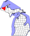
Osceola County 133 Reed City 1840 From part of Mackinac County. Was named Unwattin County until 1843. Osceola (1800?-1838), Seminole chief 23,528 573 sq mi
(1,484 km2)
Oscoda County 135 Mio 1840 From part of Mackinac County and unorganized territory. Pseudo-Native American name created by Henry Schoolcraft 8,640 572 sq mi
(1,481 km2)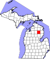
Otsego County 137 Gaylord 1840 From part of Mackinac County. Was named Okkudo County until 1843. Named for Otsego County, New York 24,164 526 sq mi
(1,362 km2)
Ottawa County 139 Grand Haven 1831 From part of Mackinac County and unorganized territory. Named for the Native American Ottawa people. 263,801 1,632 sq mi
(4,227 km2)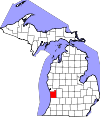
Presque Isle County 141 Rogers City 1840 From part of Mackinac County. A derivation of the French phrase for "peninsula", literally "almost an island." 13,376 2,573 sq mi
(6,664 km2)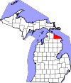
Roscommon County 143 Roscommon 1840 From part of Mackinac County and unorganized territory. Was named Mikenauk County until 1843. County Roscommon, Ireland 24,449 580 sq mi
(1,502 km2)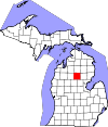
Saginaw County 145 Saginaw 1822 From part of Oakland County. A Native American term, perhaps having reference to the Sauk tribe who lived at the mouth of the river[11] 200,169 816 sq mi
(2,113 km2)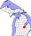
St. Clair County 147 Port Huron 1820 From part of Macomb County. Either named for Arthur St. Clair, first governor of the Northwest Territory, or for Saint Clair on whose feast day Lake St. Clair was discovered 163,040 837 sq mi
(2,168 km2)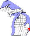
St. Joseph County 149 Centreville 1829 From unorganized territory. The St. Joseph River, which gains much of its volume within the county.[12] 61,295 521 sq mi
(1,349 km2)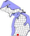
Sanilac County 151 Sandusky 1822 From part of St. Clair County. Sanilac, a Wyandotte chief 43,114 1,590 sq mi
(4,118 km2)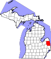
Schoolcraft County 153 Manistique 1843 From parts of Chippewa County and Mackinac County. Henry Rowe Schoolcraft, (1793-1864):
American geographer and Superintendent of Indian Affairs in Michigan8,485 1,884 sq mi
(4,880 km2)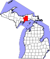
Shiawassee County 155 Corunna 1822 From parts of Oakland County and St. Clair County. Named for the Shiawassee River, and means 'river that twists about.[13] 70,648 541 sq mi
(1,401 km2)
Tuscola County 157 Caro 1840 From part of Sanilac County. Pseudo-Native American name created by Henry Schoolcraft 55,729 914 sq mi
(2,367 km2)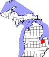
Van Buren County 159 Paw Paw 1829 From unorganized territory. Martin Van Buren (1782-1862): Secretary of State in the Jackson Administration, later Vice President and eighth President of the United States 76,258 1,090 sq mi
(2,823 km2)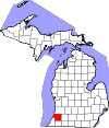
Washtenaw County 161 Ann Arbor 1822 (boundaries declared)
1826 (organised)From parts of Oakland County and Wayne County Native American people called the area west of Detroit "Wash-ten-ong," meaning "further district" or "land beyond." 344,791 723 sq mi
(1,873 km2)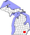
Wayne County 163 Detroit 1815 All lands within Michigan Territory that had been ceded by Native Americans through the 1807 Treaty of Detroit. "Mad" Anthony Wayne, (1745-1796):
United States Army general and statesman1,820,584 672 sq mi
(1,740 km2)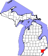
Wexford County 165 Cadillac 1840 From part of Mackinac County. Was named Kautawaubet County until 1843. County Wexford, Ireland 32,735 576 sq mi
(1,492 km2)
Defunct counties
- Brown County formed in 1818 from unorganized territory when Michigan Territory was expanded to include area west of Lake Michigan upon formation of the state of Illinois. Transferred to Wisconsin Territory in 1836 and continues as Brown County, Wisconsin.
- Keskkauko County formed in 1840 from part of Mackinac County. Renamed Charlevoix County in 1843. Annexed to Emmet County in 1853. Reformed as Charlevoix County from Emmet County in 1869.
- Crawford County formed in 1818 from unorganized territory when Michigan Territory was expanded to include area west of Lake Michigan upon formation of ths state of Illinois. Transferred to Wisconsin Territory in 1836 and continues as Crawford County, Wisconsin.
- Des Moines County formed in 1834 from unorganized territory. Transferred to Wisconsin Territory in 1836 and continues as Des Moines County, Iowa.
- Dubuque County formed in 1834 from unorganized territory. Transferred to Wisconsin Territory in 1836 and continues as Dubuque County, Iowa.
- Iowa County formed in 1830 from part of Crawford County. Transferred to Wisconsin Territory in 1836 and continues as Iowa County, Wisconsin.
- Isle Royale County formed in 1875 from part of Keweenaw County. Returned to it in 1897.
- Manitou County formed in 1855 from parts of Emmet County and Leelenau County. County government was disorganized in 1861 and attached for administrative purposes to Mackinac County. In 1865, it was attached to Leelanau and reattached to Mackinac in 1869. County was abolished in 1895 and absorbed by Charlevoix County and Leelanau County.
- Milwaukee County formed in 1834 from part of Brown County. Transferred to Wisconsin Territory in 1836 and continues as Milwaukee County, Wisconsin.
- Omeena County formed in 1840 from part of Mackinac County. Annexed to Grand Traverse County in 1853.
- Wyandot County formed in 1840 from part of Mackinac County. Annexed to Cheboygan County in 1853.
See also
- Cabinet counties
- List of abolished U.S. counties
References
- ^ Constitution of the State of Michigan, 1850, Article 10, Section 2
- ^ Constitution of the State of Michigan, 1908, Article 8, Section 2
- ^ a b Clarke Historical Library, Central Michigan University, Bibliography by county and region, including origin of county names
- ^ a b Romig, Walter; Massie, Larry B (Designer) (1986). Michigan Place Names: The History of the Founding and the Naming of More Than Five Thousand Past and Present Michigan Communities. Detroit, Michigan: Wayne State University Press. ISBN 9780814318386.
- ^ Vogel, Virgil J. (1986). Indian Names in Michigan. Ann Arbor, Michigan: University of Michigan Press. pp. 244, 8 B&W photographs & 3 maps. ISBN 978-0-472-06365-9.
- ^ Powers, Perry F.; Cutler, H.G., assisting (1912). A History of Northern Michigan and its People. http://books.google.com/books?id=L3t5AAAAMAAJ&lpg=PA961&dq=Powers%2C%20Perry%20F.%3B%20Cutler%2C%20H.G.%2C%20assisting%20(1912).%20A%20History%20of%20Northern%20Michigan%20and%20its%20People.&pg=PA961#v=onepage&q&f=false. at Google books
- ^ "Michigan Counties" from the Michigan Department of History, Arts and Libraries, which contains additional references at the end of the article
- ^ "EPA County FIPS Code Listing". EPA. http://www.epa.gov/enviro/html/codes/mi.html. Retrieved 2008-09-08.
- ^ Dan Bisher (1999). "A Brief History of 'Hillsdale County'". http://www.co.hillsdale.mi.us/hc-history.htm. Retrieved 24 November 2008.
- ^ Clarke Historical Library bibliographic entry for Newaygo County
- ^ Clarke Historical Library bibliographic entry for Saginaw County
- ^ John Marvin. "Background History on St. Joseph County". Archived from the original on 15 June 2008. http://web.archive.org/web/20080615054954/http://www.stjosephcountymi.org/history/. Retrieved 24 November 2008.
- ^ Clarke Historical Library bibliographic entry for Shiawassee County
Further reading
- Armitage, B. Phyllis. (Oct-Dec 1943). "A Study of Michigan's Place-Names". Michigan History magazine 27: 626–637.
- County histories published in Michigan History Magazine. Some back issues that include these histories are still available for purchase.
- Jenks, William L. (1912). "History and Meaning of the County Names of Michigan". Collections and Researches of the Michigan Pioneer and Historical Society 38: 439–478.
- Michigan Manual (the "Red Book") published biennially by the Legislative Service Bureau under the direction of the. Legislative Council, State of Michigan.
- Powers, Perry F.; Cutler, H.G., assisting (1912). A History of Northern Michigan and its People. http://books.google.com/books?id=L3t5AAAAMAAJ&lpg=PA961&dq=Powers%2C%20Perry%20F.%3B%20Cutler%2C%20H.G.%2C%20assisting%20(1912).%20A%20History%20of%20Northern%20Michigan%20and%20its%20People.&pg=PA961#v=onepage&q&f=false. at Google books
- Reports of Counties, Towns and Districts. I (2nd ed.). Lansing, Michigan: Robert Smith Printing Co.. 1874-6 (1900). pp. 94–520..
- Romig, Walter; Massie, Larry B (Designer) (1986). Michigan Place Names: The History of the Founding and the Naming of More Than Five Thousand Past and Present Michigan Communities. Detroit, Michigan: Wayne State University Press. ISBN 9780814318386.
- Vogel, Virgil J. (1986). Indian Names in Michigan. Ann Arbor, Michigan: University of Michigan Press. pp. 244, 8 B&W photographs & 3 maps. ISBN 978-0-472-06365-9.
 State of Michigan
Lansing (capital) Topics Index · Congressional delegation · Geography · Governors · History · Islands · Legislature · Lieutenant Governors · Lighthouses · Museums · National Historic Landmarks · National Register of Historic Places listings · People · State Historic Sites · State parks · Supreme Court · Tallest buildings · Timeline · Topics · Visitor attractions
Regions Largest
MunicipalitiesAlpena · Ann Arbor · Battle Creek · Bay City · Bloomfield Township · Canton Township · Chesterfield Township · Clinton Township · Commerce Township · Dearborn · Dearborn Heights · Detroit · East Lansing · Eastpointe · Farmington Hills · Flint · Flint Township · Georgetown Township · Grand Rapids · Holland · Jackson · Kalamazoo · Kentwood · Lansing · Lincoln Park · Livonia · Macomb Township · Meridian Township · Midland · Muskegon · Novi · Pontiac · Portage · Redford · Rochester Hills · Roseville · Royal Oak · Saginaw · Saginaw Township · St. Clair Shores · Shelby Township · Southfield · Sterling Heights · Taylor · Troy · Warren · Waterford Township · West Bloomfield · Westland · Wyoming · Ypsilanti Township
Counties Alcona · Alger · Allegan · Alpena · Antrim · Arenac · Baraga · Barry · Bay · Benzie · Berrien · Branch · Calhoun · Cass · Charlevoix · Cheboygan · Chippewa · Clare · Clinton · Crawford · Delta · Dickinson · Eaton · Emmet · Genesee · Gladwin · Gogebic · Grand Traverse · Gratiot · Hillsdale · Houghton · Huron · Ingham · Ionia · Iosco · Iron · Isabella · Jackson · Kalamazoo · Kalkaska · Kent · Keweenaw · Lake · Lapeer · Leelanau · Lenawee · Livingston · Luce · Mackinac · Macomb · Manistee · Marquette · Mason · Mecosta · Menominee · Midland · Missaukee · Monroe · Montcalm · Montmorency · Muskegon · Newaygo · Oakland · Oceana · Ogemaw · Ontonagon · Osceola · Oscoda · Otsego · Ottawa · Presque Isle · Roscommon · Saginaw · Sanilac · Schoolcraft · Shiawassee · St. Clair · St. Joseph · Tuscola · Van Buren · Washtenaw · Wayne · Wexford
External links
- Clarke Historical Library, Central Michigan University, Bibliography by county and region, including origin of county names.
- Freelang Ojibwe Dictionary
- maps of Michigan county formation
- History of County Creation
- Michigan County History and atlases, digitized database, including Powers, Perry F., assisted by H.G. Cutler, A History of Northern Michigan and its People (1912).
- Michigan County names per the Michigan government.
- Table of dates counties laid out and organized
- History of the name "Sheboygan".
- American FactFinder for the 2010 Census
Categories:- Michigan counties
- Lists of U.S. counties by state


Wikimedia Foundation. 2010.