- List of counties in Georgia (U.S. state)
-
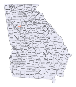
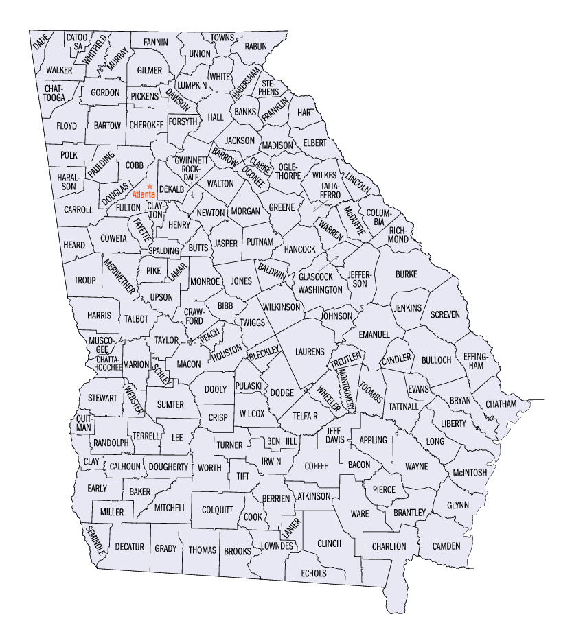
The U.S. state of Georgia is divided into 159 counties. Under the Georgia State Constitution, all of its counties are granted home rule to deal with issues that are purely local in nature. Four consolidated city-counties have been established in Georgia: Athens (Clarke County), Augusta (Richmond County), Columbus (Muscogee County), and Cusseta (Chattahoochee County).
Contents
History
Georgia has the second highest number of counties of any state in the United States, next behind the geographically huge State of Texas, which has 254 counties (see List of counties in Texas). One traditional reasoning for the creation and location of counties was that a country farmer, rancher, etc., should be able to travel to the legal county seat town or city, and back home, in one day on horseback or via wagon. However, about 25 counties in Georgia have been created in the 20th century—after the use of the automobile, truck, and bus had become widespread. These 25 or so counties are generally thought of as having being created because of political reasons.[citation needed] The last new county to be established in Georgia was Peach County, established in 1924.
The proliferation of counties in Georgia led to multiple state constitutional amendments attempting to establish a limit on the number of counties in the state. The most recent such amendment, adopted in 1945, limits the number to 159 counties, although there had been 161 counties there from 1924 to 1931. In a very rare consolidation of counties, both Campbell County and Milton County were annexed to Fulton County in 1932 as a financial move during the Great Depression. Fulton County contains Atlanta, and it was thought that tax revenues from Atlanta and its (small) suburbs then would help to support the quite rural areas of the terminated counties, which had nearly no tax income of their own.
Changed names of counties in Georgia
A few counties in Georgia have had their names changed in the history of the state. Jasper County was originally named "Randolph County". Later on, the present-day Randolph County was established. Webster County was once named "Kinchafoonee County", and Cass County was renamed Bartow County.
Defunct counties in Georgia
- St. George, St. Mary's, St. Thomas, St. Phillip, Christ Church, St. David, St. Matthews, St. Andrew, St. James, St. Johns, and St. Paul Parishes. These were all dissolved in 1777, and other counties were established later on.
- Campbell County (1828–1932): Formed from Carroll and Coweta Counties in 1828, this was merged into Fulton County in 1932.
- Milton County (1857–1932): Formed from Cobb County in 1857, this was merged into Fulton County in 1932.
In addition, there was a previous Walton County, Georgia, which was actually located in present-day North Carolina. A brief skirmish, the so-called Walton War, was fought between North Carolina and Georgia before Georgia relinquished its claim on the area.
Counties listing
County FIPS code
[1]County seat
[2]Established
[2]Origin
[3]Etymology
[3]Population
[2]Area
[2]Map Appling County 001 Baxley 1818 Land ceded by the Creek Indians in the Treaty of Fort Jackson in 1814 and the Treaty of the Creek Agency in 1818. Colonel Daniel Appling (1787–1818), hero of the War of 1812. 17,419 509 sq mi
(1,318 km2)
Atkinson County 003 Pearson 1917 Clinch and Coffee Counties William Yates Atkinson (1854–1899), governor of Georgia (1894–1898) and speaker of the Georgia House of Representatives. 7,609 338 sq mi
(875 km2)
Bacon County 005 Alma 1914 Appling, Pierce and Ware Counties Augustus Octavius Bacon (1839–1914), U.S. Senator (1895–1914); president pro tempore of the United States Senate. 10,103 285 sq mi
(738 km2)
Baker County 007 Newton 1825 Early County. Colonel John Baker (d.1792), American Revolutionary War hero. 4,074 343 sq mi
(888 km2)
Baldwin County 009 Milledgeville 1803 Creek cessions of 1802 and 1805. Abraham Baldwin (1754–1807), Founding Father, U.S. Senator (1799–1807), one of the Georgia delegates who signed the U.S. Constitution. 44,700 258 sq mi
(668 km2)
Banks County 011 Homer 1858 Franklin and Habersham Counties Dr. Richard Banks (1784–1850), a local physician noted for treating natives with smallpox. 14,422 234 sq mi
(606 km2)
Barrow County 013 Winder 1914 Gwinnett, Jackson and Walton counties. "Uncle Dave" David Crenshaw Barrow Jr. (1852–1929), chancellor of the University of Georgia (1906–1929). 46,144 162 sq mi
(420 km2)
Bartow County 015 Cartersville 1832 Created from a portion of Cherokee County in 1832 and originally called Cass County after General Lewis Cass. General Francis S. Bartow (1816–1861), Confederate political leader, first Confederate general killed in the American Civil War. 76,019 460 sq mi
(1,191 km2)
Ben Hill County 017 Fitzgerald 1906 Irwin and Wilcox counties. Benjamin Harvey Hill (1823–1882), U.S. Senator (1877–1882). 17,484 252 sq mi
(653 km2)
Berrien County 019 Nashville 1856 Coffee, Irwin, and Lowndes counties. John MacPherson Berrien (1781–1856), U.S. Senator, United States Attorney General. 16,235 452 sq mi
(1,171 km2)
Bibb County 021 Macon 1822 portions of Houston, Jones, Monroe and Twiggs counties. Dr. William Wyatt Bibb (1780–1820), first Governor of Alabama, U.S. Senator. 153,887 250 sq mi
(647 km2)
Bleckley County 023 Cochran 1912 Pulaski County. Logan Edwin Bleckley (1827–1907), Georgia State Supreme Court Chief Justice. 11,666 217 sq mi
(562 km2)
Brantley County 025 Nahunta 1920 Charlton, Pierce, and Wayne counties. William Gordon Brantley (1860–1934), U.S. Congressman. 14,629 444 sq mi
(1,150 km2)
Brooks County 027 Quitman 1858 Lowndes and Thomas counties Captain Preston S. Brooks (1819–1857), hero of the Mexican–American War and Congressman from South Carolina. 16,450 494 sq mi
(1,279 km2)
Bryan County 029 Pembroke 1793 Chatham County Jonathan Bryan (1708–1788), a colonial settler and famous state representative. 23,417 442 sq mi
(1,145 km2)
Bulloch County 031 Statesboro 1796 Bryan and Screven Counties Archibald Bulloch (1729–1777), Revolutionary War soldier, Speaker of the Georgia House of Representatives, and acting governor of Georgia (1775–1777). 55,983 683 sq mi
(1,769 km2)
Burke County 033 Waynesboro 1777 Originally organized as St George Parish. Edmund Burke (1729–1797), British political philosopher and Member of Parliament who was sympathetic to the cause of US independence. 22,243 831 sq mi
(2,152 km2)
Butts County 035 Jackson 1825 Henry and Monroe counties. Captain Samuel Butts (1777–1814), a hero of the Creek War. 19,522 187 sq mi
(484 km2)
Calhoun County 037 Morgan 1854 Early and Baker counties. John C. Calhoun (1782–1850), US Representatative, Senator, and Vice President from South Carolina. 6,320 280 sq mi
(725 km2)
Camden County 039 Woodbine 1777 St Mary and St Thomas Parishes. Sir Charles Pratt, 1st Earl Camden (1714–1794), Lord Chancellor of Great Britain who was sympathetic to the cause of the Revolution. 43,664 630 sq mi
(1,632 km2)
Candler County 043 Metter 1914 Bulloch, Emanuel and Tattnall counties. Allen Daniel Candler (1834–1910), state legislator, U.S. Representative and Governor of Georgia (1898–1902). 9,577 247 sq mi
(640 km2)
Carroll County 045 Carrollton 1826 Created by the state legislature from lands ceded by the Creek Indians in 1825 in the Treaty of Indian Springs. Charles Carroll (1737–1832), the last living signer of the Declaration of Independence. 87,268 499 sq mi
(1,292 km2)
Catoosa County 047 Ringgold 1853 Walker and Whitfield counties. Chief Catoosa, a Cherokee chief. 53,282 162 sq mi
(420 km2)
Charlton County 049 Folkston 1854 Camden County. Robert Milledge Charlton (1807–1854), jurist, U.S. Senator (1852–1854), and mayor of Savannah. 10,282 781 sq mi
(2,023 km2)
Chatham County 051 Savannah 1777 Christ Church and St Philip Parishes. William Pitt, 1st Earl of Chatham (1708–1778), British Prime Minister sympathetic to the Revolutionary cause. 232,048 440 sq mi
(1,140 km2)
Chattahoochee County 053 Cusseta 1854 Muscogee and Marion counties. Chattahoochee River, which forms the county's (and the state's) western border. 14,882 249 sq mi
(645 km2)
Chattooga County 055 Summerville 1838 Walker and Floyd counties. Chattooga River. 25,470 314 sq mi
(813 km2)
Cherokee County 057 Canton 1831 Cherokee Cession of 1831. Cherokee Nation, which controlled this part of the state autonomously until 1831. 141,903 424 sq mi
(1,098 km2)
Clarke County 059 Athens 1801 Jackson County. Elijah Clarke (1733–1799), a Revolutionary War hero. 101,489 121 sq mi
(313 km2)
Clay County 061 Fort Gaines 1854 Randolph and Early counties. Henry Clay (1777–1852), Secretary of State, Speaker of the House of Representatives, and U.S. Senator from Kentucky. 3,357 195 sq mi
(505 km2)
Clayton County 063 Jonesboro 1858 Fayette and Henry counties. Augustin Smith Clayton (1783–1839), a local jurist and U.S. Representative. 236,517 143 sq mi
(370 km2)
Clinch County 065 Homerville 1850 Lowndes and Ware counties. General Duncan Lamont Clinch (1784–1849), a hero of the War of 1812 and the Seminole War and U.S. Representative. 6,878 809 sq mi
(2,095 km2)
Cobb County 067 Marietta 1832 Cherokee County Colonel Thomas Willis Cobb (1784–1835), a hero of the War of 1812 and U.S. Congressman. 607,751 340 sq mi
(881 km2)
Coffee County 069 Douglas 1854 Clinch, Irwin, Telfair and Ware counties. General John E. Coffee (1782–1836), a hero of the War of 1812. 37,413 599 sq mi
(1,551 km2)
Colquitt County 071 Moultrie 1856 Thomas and Lowndes counties. Walter Terry Colquitt (1799–1855), Methodist preacher and U.S. Senator. 42,053 552 sq mi
(1,430 km2)
Columbia County 073 Appling 1790 Richmond County Christopher Columbus (1446–1506), explorer. 89,288 290 sq mi
(751 km2)
Cook County 075 Adel 1918 Berrien County. General Philip Cook (1817–1894), Confederate general and secretary of state. 15,771 229 sq mi
(593 km2)
Coweta County 077 Newnan 1826 Created on Creek lands ceded in 1825 in the treaty of Indian Springs and Creek Cessions of 1826. Coweta tribe of the Creek Nation and their village near Columbus. 89,215 443 sq mi
(1,147 km2)
Crawford County 079 Knoxville 1822 Houston County. William Harris Crawford (1772–1834), U.S. Senator, minister to France and Secretary of the Treasury. 12,495 325 sq mi
(842 km2)
Crisp County 081 Cordele 1905 Dooly County. Charles Frederick Crisp (1845–1896), speaker of the U.S. House of Representatives. 21,996 274 sq mi
(710 km2)
Dade County 083 Trenton 1837 Walker County. Major Francis L. Dade (1793–1835), hero of the Seminole War. 15,154 174 sq mi
(451 km2)
Dawson County 085 Dawsonville 1857 Gilmer and Lumpkin counties. William Crosby Dawson (1798–1857), U.S. Senator (1849–1855) and state legislator. 15,999 211 sq mi
(546 km2)
Decatur County 087 Bainbridge 1823 Early County. Commodore Stephen Decatur (1779–1820), a War of 1812 naval hero. 28,240 597 sq mi
(1,546 km2)
DeKalb County 089 Decatur 1822 Henry, Gwinnett, and Fayette counties. "Baron" Johann DeKalb (1721–1780) a German who accompanied the Marquis de Lafayette and was inspector general of the Colonial Army. 665,865 268 sq mi
(694 km2)
Dodge County 091 Eastman 1870 Montgomery, Pulaski and Telfair counties. William Earle Dodge (1805–1883), a New York temperance leader, businessman, and cofounder of Phelps, Dodge and Company, a mining and metals company. 19,171 501 sq mi
(1,298 km2)
Dooly County 093 Vienna 1821 Creek Cession of 1821. Colonel John Dooly (1740–1780), a hero of the American Revolution. 11,525 393 sq mi
(1,018 km2)
Dougherty County 095 Albany 1853 Baker County. Charles Dougherty (1801–1853), a noted Athens judge. 96,065 330 sq mi
(855 km2)
Douglas County 097 Douglasville 1870 Campbell and Carroll counties. Stephen Arnold Douglas (1813–1861), an Illinois Democratic Congressman who ran against Abraham Lincoln in the United States presidential election, 1860 and lost. 92,174 199 sq mi
(515 km2)
Early County 099 Blakely 1818 Creek Cession of 1814. Peter Early (1773–1817), tenth governor of Georgia. 12,354 511 sq mi
(1,323 km2)
Echols County 101 Statenville 1858 Clinch and Lowndes Counties General Robert M. Echols (1798–1847), state legislator and hero of the Mexican-American War. 3,754 404 sq mi
(1,046 km2)
Effingham County 103 Springfield 1777 St Mathew and St Philip Parishes. Thomas Howard, Third Earl of Effingham (1746–1791), who was sympathetic to the independence movement. 37,535 480 sq mi
(1,243 km2)
Elbert County 105 Elberton 1790 Wilkes County Samuel Elbert (1740–1788) a General in the Revolutionary War, who became the governor of Georgia in 1785 20,511 369 sq mi
(956 km2)
Emanuel County 107 Swainsboro 1812 Bulloch and Montgomery Counties Colonel David Emanuel (1744–1808), who became governor of Georgia in 1801. 21,837 686 sq mi
(1,777 km2)
Evans County 109 Claxton 1914 Bulloch and Tattnall County General Clement Anselm Evans (1832–1911), hero of the Civil War and commander in chief of the United Confederate Veterans. 10,495 185 sq mi
(479 km2)
Fannin County 111 Blue Ridge 1854 Gilmer and Union Counties Colonel James Walker Fannin Jr. (1809–1836), hero of the Texas Revolution. 19,798 386 sq mi
(1,000 km2)
Fayette County 113 Fayetteville 1821 Creek Cession of 1821. Gilbert du Motier, marquis de Lafayette (1757–1834), French hero of the Revolutionary War. 91,263 197 sq mi
(510 km2)
Floyd County 115 Rome 1832 Cherokee County General John Floyd (1769–1839), Indian fighter and U.S. Representative. 90,565 513 sq mi
(1,329 km2)
Forsyth County 117 Cumming 1832 Cherokee County John Forsyth (1780–1841), Secretary of State under President Martin Van Buren. 98,407 226 sq mi
(585 km2)
Franklin County 119 Carnesville 1784 Cherokee and Creek Cessions of 1783 Benjamin Franklin (1706–1790), writer, inventor, publisher, and Founding Father of the United States. 20,285 263 sq mi
(681 km2)
Fulton County 121 Atlanta 1853 DeKalb County + the former Campbell and Milton Counties and a portion of Cobb County Robert Fulton, engineer and inventor of the steamboat. 816,006 529 sq mi
(1,370 km2)
Gilmer County 123 Ellijay 1832 Cherokee County George Rockingham Gilmer (1780–1859), 16th governor of Georgia. 23,456 427 sq mi
(1,106 km2)
Glascock County 125 Gibson 1857 Warren County General Thomas Glascock (1780–1841), hero of the War of 1812 and the Seminole War of 1817, and U.S. Representative. 2,556 144 sq mi
(373 km2)
Glynn County 127 Brunswick 1777 St David and St Patrick Parishes John Glynn (1722–1779), British Member of Parliament and Serjeant-at-law, who was sympathetic to the cause of American independence. 67,568 422 sq mi
(1,093 km2)
Gordon County 129 Calhoun 1850 Cass (now Bartow) and Floyd Counties William Washington Gordon (1796–1842), first president of the Central of Georgia Railroad. 44,104 355 sq mi
(919 km2)
Grady County 131 Cairo 1905 Decatur and Thomas Counties Henry Woodfin Grady (1850–1889), famous orator and managing editor of the Atlanta Constitution. 23,659 458 sq mi
(1,186 km2)
Greene County 133 Greensboro 1786 Washington County General Nathanael Greene (1742–1786), hero of the Revolutionary War. 14,406 388 sq mi
(1,005 km2)
Gwinnett County 135 Lawrenceville 1818 Cherokee Cession of 1817 and Creek Cession of 1818. Button Gwinnett (1735–1777), one of Georgia's delegates to the Continental Congress who signed the Declaration of Independence. 757,104 433 sq mi
(1,121 km2)
Habersham County 137 Clarkesville 1818 Cherokee Cessions of 1817 and 1819 Colonel Joseph Habersham (1751–1815), hero of the Revolutionary War and Postmaster General in the Cabinet of George Washington. 35,902 278 sq mi
(720 km2)
Hall County 139 Gainesville 1818 Cherokee Cessions of 1817 and 1819 Dr. Lyman Hall (1724–1790), one of Georgia's delegates to the Continental Congress who signed the Declaration of Independence. He became governor of Georgia in 1783. 139,277 394 sq mi
(1,020 km2)
Hancock County 141 Sparta 1793 Greene and Washington counties John Hancock (1737–1793), president of the Continental Congress and the first signer of the Declaration of Independence. 10,076 473 sq mi
(1,225 km2)
Haralson County 143 Buchanan 1856 Carroll and Polk Counties General Hugh Anderson Haralson (1805–1854), US Congressman. 25,690 282 sq mi
(730 km2)
Harris County 145 Hamilton 1827 Muscogee and Troup counties Charles Harris (1772–1827), a prominent Savannah attorney. 23,695 464 sq mi
(1,202 km2)
Hart County 147 Hartwell 1853 Elbert and Franklin counties Nancy Morgan Hart (1735–1830), heroine of the Revolutionary War. 22,997 232 sq mi
(601 km2)
Heard County 149 Franklin 1830 Carroll, Coweta and Troup Counties Stephen Heard (1740–1815), hero of the Revolutionary War. 11,012 296 sq mi
(767 km2)
Henry County 151 McDonough 1821 Creek Cession of 1821 Patrick Henry (1736–1799), prominent lawyer, orator, and Founding Father of the United States. 119,341 323 sq mi
(837 km2)
Houston County 153 Perry 1821 Creek Cession of 1821 John Houstoun (1744–1796), member of the Continental Congress who became governor of Georgia in 1778. 110,765 377 sq mi
(976 km2)
Irwin County 155 Ocilla 1818 Creek Cessions of 1814 and 1818 Jared Irwin (1751–1818), governor who rescinded the Yazoo Act in 1796. 9,931 357 sq mi
(925 km2)
Jackson County 157 Jefferson 1796 Franklin County General James Jackson (1757–1806), hero of the Revolutionary War. 41,589 342 sq mi
(886 km2)
Jasper County 159 Monticello 1807 Baldwin (FKA Randolph County 1807–1812) Sergeant William Jasper (1750–1779), hero of the Revolutionary War. 11,426 370 sq mi
(958 km2)
Jeff Davis County 161 Hazlehurst 1905 Appling and Coffee counties Jefferson Davis (1808–1889), first and only President of the Confederate States of America. 12,684 333 sq mi
(862 km2)
Jefferson County 163 Louisville 1796 Burke and Warren Counties Thomas Jefferson (1743–1826), third President of the United States. 17,266 528 sq mi
(1,368 km2)
Jenkins County 165 Millen 1905 Bulloch, Burke, Emanuel, and Screven Counties Charles Jones Jenkins (1805–1883), governor of Georgia, who was the author of the famous Georgia Platform of 1850. 8,575 350 sq mi
(906 km2)
Johnson County 167 Wrightsville 1858 Emanuel, Laurens and Washington counties Herschel Vespasian Johnson (1812–1880), U.S. Senator and Georgia governor. 8,560 304 sq mi
(787 km2)
Jones County 169 Gray 1807 Baldwin County James Jones (1769–1801), U.S. Congressman. 23,639 394 sq mi
(1,020 km2)
Lamar County 171 Barnesville 1920 Monroe and Pike Counties Lucius Quintus Cincinnatus Lamar (1825–1893), U.S. Senator and justice of the U.S. Supreme Court. 15,912 185 sq mi
(479 km2)
Lanier County 173 Lakeland 1920 Berrien, Clinch and Lowndes Countries Sidney Lanier (1842–1881), famous attorney, linguist, mathematician, and musician. 7,241 187 sq mi
(484 km2)
Laurens County 175 Dublin 1807 Wilkinson County Colonel John Laurens (1754–1782), aide to George Washington during the Revolutionary War. 44,874 813 sq mi
(2,106 km2)
Lee County 177 Leesburg 1826 Creek Cessions of 1826 General Richard Henry Lee (1732–1794), hero of the Revolutionary War. 24,757 356 sq mi
(922 km2)
Liberty County 179 Hinesville 1777 St Andrew, St James, and St John Parishes Named in honor of the noted patriotism of the citizens of Midway in their support of the cause of colonial independence. 61,610 519 sq mi
(1,344 km2)
Lincoln County 181 Lincolnton 1796 Wilkes County General Benjamin Lincoln (1733–1810), hero of the Revolutionary War who was later assigned to the suppression of Shays' Rebellion. 8,348 211 sq mi
(546 km2)
Long County 183 Ludowici 1920 Liberty County Dr. Crawford Williamson Long (1815–1878), in 1842 the first man to use diethyl ether as an anesthetic for surgery. 10,304 401 sq mi
(1,039 km2)
Lowndes County 185 Valdosta 1825 Irwin County William Jones Lowndes (1782–1822), a prominent figure in the affairs of South Carolina throughout the formative years of the United States. 92,115 504 sq mi
(1,305 km2)
Lumpkin County 187 Dahlonega 1832 Cherokee, Habersham, and Hall Counties Wilson Lumpkin (1783–1870), governor of Georgia and U.S. Senator. 21,016 284 sq mi
(736 km2)
Macon County 193 Oglethorpe 1837 Houston and Marion Counties General Nathaniel Macon (1758–1837), Speaker of the House of Representatives and U.S. Senator. 14,074 403 sq mi
(1,044 km2)
Madison County 195 Danielsville 1811 Clarke, Elbert, Franklin, Jackson and Oglethorpe Counties James Madison (1751–1836), fourth President of the United States and chief drafter of the Constitution. 25,730 284 sq mi
(736 km2)
Marion County 197 Buena Vista 1827 Lee and Muscogee Counties General Francis Marion (1732–1795), the "Swamp Fox," hero of the Revolutionary War. 7,144 367 sq mi
(951 km2)
McDuffie County 189 Thomson 1870 Columbia and Warren George McDuffie (1790–1851), famous orator and governor of South Carolina. 21,231 260 sq mi
(673 km2)
McIntosh County 191 Darien 1793 Liberty County General Lachlan McIntosh (1727–1806), hero of the Revolutionary War. 10,847 434 sq mi
(1,124 km2)
Meriwether County 199 Greenville 1827 Formed form Troup County General David Meriwether (1755–1822), a hero of the Revolutionary War and a U.S. Representative. 22,534 503 sq mi
(1,303 km2)
Miller County 201 Colquitt 1856 Baker and Early Counties Andrew Jackson Miller (1806–1856), president of the Medical College of Georgia. 6,383 283 sq mi
(733 km2)
Mitchell County 205 Camilla 1857 Baker County Gen. Henry Mitchell (1760–1839), hero of the Revolutionary War. 23,932 512 sq mi
(1,326 km2)
Monroe County 207 Forsyth 1821 Creek Cession of 1821 James Monroe (1758–1831), fifth President of the United States and author of the Monroe Doctrine of 1823. 21,757 396 sq mi
(1,026 km2)
Montgomery County 209 Mount Vernon 1793 Washington County General Richard Montgomery (1738–1775), hero of the Revolutionary War. 8,270 245 sq mi
(635 km2)
Morgan County 211 Madison 1807 Baldwin County General Daniel Morgan (1736–1802), hero of the Revolutionary War and U.S. Representative. 15,457 350 sq mi
(906 km2)
Murray County 213 Chatsworth 1832 Cherokee County Thomas W. Murray (1790–1832), famous state legislator. 36,506 344 sq mi
(891 km2)
Muscogee County 215 Columbus 1826 Creek Cession of 1826 Muskogee ethnic group, to which the Creek and Seminole Nations belong. 186,291 216 sq mi
(559 km2)
Newton County 217 Covington 1821 Henry, Jasper, and Walton Counties Sergeant John Newton (1755–1780), hero of the Revolutionary War. 62,001 276 sq mi
(715 km2)
Oconee County 219 Watkinsville 1875 Clarke County Oconee River, which forms its eastern boundary. 32,808 186 sq mi
(482 km2)
Oglethorpe County 221 Lexington 1793 Wilkes County General James Edward Oglethorpe (1696–1785), the founder of the colony of Georgia. 12,635 441 sq mi
(1,142 km2)
Paulding County 223 Dallas 1832 Cherokee County John Paulding (1759–1818), hero of the Revolutionary War. 81,678 314 sq mi
(813 km2)
Peach County 225 Fort Valley 1924 Houston and Macon Counties Its location in Central Georgia is one of the richest peach producing regions in the state. 23,668 151 sq mi
(391 km2)
Pickens County 227 Jasper 1853 Cherokee and Gilmer counties General Andrew Pickens (1739–1817), hero of the Revolutionary War and U.S. Representative. 22,983 232 sq mi
(601 km2)
Pierce County 229 Blackshear 1857 Appling and Ware Counties Franklin Pierce (1804–1869), fourteenth President of the United States. 15,636 343 sq mi
(888 km2)
Pike County 231 Zebulon 1822 Monroe County General Zebulon Pike (1779–1813), explorer and hero of the War of 1812. 13,688 218 sq mi
(565 km2)
Polk County 233 Cedartown 1851 Floyd and Paulding Counties James Knox Polk (1795–1849), eleventh President of the United States. 38,127 311 sq mi
(805 km2)
Pulaski County 235 Hawkinsville 1808 Laurens County Count Kazimierz Pułaski of Poland (1748–1779), hero of the Revolutionary War. 9,588 247 sq mi
(640 km2)
Putnam County 237 Eatonton 1807 Baldwin County General Israel Putnam (1718–1790), hero of the Revolutionary War. 18,812 344 sq mi
(891 km2)
Quitman County 239 Georgetown 1858 Randolph and Stewart counties General John Anthony Quitman (1799–1858), hero of the Mexican-American War. 2,598 152 sq mi
(394 km2)
Rabun County 241 Clayton 1819 Cherokee Cession of 1819 William Rabun (1771–1819), governor of Georgia (1817–19). 15,050 371 sq mi
(961 km2)
Randolph County 243 Cuthbert 1828 Lee County John Randolph of Roanoke (1773–1833), U.S. Representative. 7,791 429 sq mi
(1,111 km2)
Richmond County 245 Augusta 1777 St Paul Parish Charles Lennox, 3rd Duke of Richmond (1735–1806), who was sympathetic to the cause of colonial independence. 199,775 324 sq mi
(839 km2)
Rockdale County 247 Conyers 1870 Henry and Newton counties Rockdale Church, which was so named for the subterranean bed of granite that underlies this region of the state. 70,111 131 sq mi
(339 km2)
Schley County 249 Ellaville 1857 Marion and Sumter counties William Schley (1786–1858), governor of Georgia (1835–1837). 3,766 168 sq mi
(435 km2)
Screven County 251 Sylvania 1793 Burke and Effingham Counties General James Screven (1744–1778), hero of the Revolutionary War. 15,374 648 sq mi
(1,678 km2)
Seminole County 253 Donalsonville 1920 Decatur and Early Counties Seminole Nation 9,369 238 sq mi
(616 km2)
Spalding County 255 Griffin 1851 Fayette, Henry, and Pike County Thomas Spalding (1774–1851), U.S. Representative; Georgia delegate to the Constitutional convention of 1798. 58,417 198 sq mi
(513 km2)
Stephens County 257 Toccoa 1905 Franklin and Habersham Counties Alexander Stephens (1812–1883), U.S. Representative; governor of Georgia; first and only Vice President of the Confederate States of America. 25,435 179 sq mi
(464 km2)
Stewart County 259 Lumpkin 1830 Randolph County General Daniel Stewart (1759–1829), hero of the Revolutionary War and the War of 1812. 5,252 459 sq mi
(1,189 km2)
Sumter County 261 Americus 1831 Lee County General Thomas Sumter (1734–1832), the "Fighting Gamecock," hero of the Revolutionary War. 33,200 485 sq mi
(1,256 km2)
Talbot County 263 Talbotton 1827 Muscogee County Matthew Talbot (1762–1827), served in the Georgia State Senate for 15 years, including two as Senate President; governor of Georgia for two weeks (1819). 6,498 393 sq mi
(1,018 km2)
Taliaferro County 265 Crawfordville 1825 Greene, Hancock, Oglethorpe, Warren, and Wilkes Counties Colonel Benjamin Taliaferro (1750–1821), U.S. Representative and hero of the Revolutionary War. 2,077 195 sq mi
(505 km2)
Tattnall County 267 Reidsville 1801 Montgomery County Josiah Tattnall (1764–1803), U.S. Senator and governor of Georgia. 22,305 484 sq mi
(1,254 km2)
Taylor County 269 Butler 1852 Macon, Marion and Talbot Counties Zachary Taylor (1784–1850), twelfth President of the United States. 8,815 378 sq mi
(979 km2)
Telfair County 271 McRae 1807 Wilkinson County Edward Telfair (1735–1807), second governor of Georgia after the establishment of the United States. 11,794 441 sq mi
(1,142 km2)
Terrell County 273 Dawson 1856 Lee and Randolph Counties Dr. William Terrell (1778–1855), U.S. Representative. 10,970 336 sq mi
(870 km2)
Thomas County 275 Thomasville 1825 Decatur and Irwin Counties General Jett Thomas (1776–1817), hero of the War of 1812. 42,737 548 sq mi
(1,419 km2)
Tift County 277 Tifton 1905 Berrien, Irwin and Worth Counties Colonel Nelson Tift (1810–1891), Confederate States Navy captain; U.S. Representative. 38,407 265 sq mi
(686 km2)
Toombs County 279 Lyons 1905 Emanuel, Tattnall, and Montgomery Counties General Robert Toombs (1810–1885), U.S. Senator; Confederate States Secretary of State. 26,067 367 sq mi
(951 km2)
Towns County 281 Hiawassee 1856 Rabun and Union Counties George Washington Towns (1801–1854), governor of Georgia during the antebellum period. 9,319 166 sq mi
(430 km2)
Treutlen County 283 Soperton 1917 Emanuel and Montgomery Counties John A. Treutlen (1726–1782), first elected governor of Georgia (1777–1778). 6,854 201 sq mi
(521 km2)
Troup County 285 Lagrange 1826 Creek Cession of 1826 George M. Troup (1780–1856), governor of Georgia (1823–1827) and U.S. Senator. 58,779 414 sq mi
(1,072 km2)
Turner County 287 Ashburn 1905 Dooly, Irwin, Wilcox and Worth Counties Captain Henry Gray Turner (1839–1904), U.S. Representative and hero of the Civil War. 9,504 286 sq mi
(741 km2)
Twiggs County 289 Jeffersonville 1809 Wilkinson County General John Twiggs (1750–1816), hero of the Revolutionary War, governor of Georgia. 10,590 360 sq mi
(932 km2)
Union County 291 Blairsville 1832 Cherokee County Federal union of the states. 17,289 323 sq mi
(837 km2)
Upson County 293 Thomaston 1824 Crawford and Pike Counties Stephen Upson (1786–1824), famous state legislator. 27,597 326 sq mi
(844 km2)
Walker County 295 Lafayette 1833 Murray County Major Freeman Walker (1780–1827), U.S. Senator (1819–1821). 61,053 446 sq mi
(1,155 km2)
Walton County 297 Monroe 1818 Creek Cession of 1818 George Walton (1749–1804), one of Georgia's delegates to the Continental Congress who signed the Declaration of Independence. 60,687 329 sq mi
(852 km2)
Ware County 299 Waycross 1824 Appling County Nicholas Ware (1769–1824), U.S. Senator (1821–1824). 35,483 903 sq mi
(2,339 km2)
Warren County 301 Warrenton 1793 Columbia, Hancock, Richmond, and Wilkes Counties General Joseph Warren (1741–1775), hero of the Revolutionary War. 6,336 286 sq mi
(741 km2)
Washington County 303 Sandersville 1784 Creek Cession of 1783 George Washington (1732–1799), first President of the United States. 21,176 680 sq mi
(1,761 km2)
Wayne County 305 Jesup 1803 Creek Cession of 1802 General Anthony Wayne (1745–1796); known as "Mad Anthony"; U.S. Representatives; hero of the Revolutionary and Northwest Indian Wars. 26,565 645 sq mi
(1,671 km2)
Webster County 307 Preston 1853 Stewart County (Formally Kinchafoonee) Daniel Webster (1782–1852), United States Secretary of State, supported Clay's Compromise of 1850. 2,390 210 sq mi
(544 km2)
Wheeler County 309 Alamo 1912 Montgomery County General Joseph Wheeler (1836–1906), U.S. Representative; hero of the Civil War and the Spanish–American War. 6,179 298 sq mi
(772 km2)
White County 311 Cleveland 1857 Habersham County Colonel John White, hero of the Revolutionary War. 19,944 242 sq mi
(627 km2)
Whitfield County 313 Dalton 1851 Murray County George Whitefield (1714–1770), famous preacher who established Bethesda Orphanage near Savannah. 83,525 290 sq mi
(751 km2)
Wilcox County 315 Abbeville 1857 Dooly, Irwin, and Pulaski counties General Mark Wilcox (1800–1850), a famous soldier and state legislator. 8,577 380 sq mi
(984 km2)
Wilkes County 317 Washington 1777 Cherokee and Creek Cessions of 1773 John Wilkes (1727–1797), distinguished British Member of Parliament who sympathized with the cause of American independence. 10,687 471 sq mi
(1,220 km2)
Wilkinson County 319 Irwinton 1803 Creek Cessions of 1802 and 1805 General James Wilkinson (1757–1825), hero of the Revolution and the War of 1812. 10,220 447 sq mi
(1,158 km2)
Worth County 321 Sylvester 1853 Dooly and Irwin Counties General William J. Worth (1794–1849), hero of the Mexican-American War. 21,967 570 sq mi
(1,476 km2)
References
- ^ "EPA County FIPS Code Listing". EPA.gov. http://www.epa.gov/enviro/html/codes/ga.html. Retrieved 2008-02-23.
- ^ a b c d National Association of Counties. "NACo - Find a county". http://www.naco.org/Template.cfm?Section=Find_a_County&Template=/cffiles/counties/state.cfm&state.cfm&statecode=GA. Retrieved 2008-04-30.
- ^ a b "New Georgia Encyclopedia". http://www.newgeorgiaencyclopedia.org/nge/Categories.jsp?path=/CitiesCounties/Counties#/CitiesCounties/Counties. Retrieved 2008-06-18.
External links
- Historical Atlas of Georgia Counties
- Article IX of the Constitution of Georgia, on counties and municipal corporations
- History of Walton County
- Walton War
- List of Digital Library of Georgia collections by county
- New Georgia Encyclopedia
- Historic Georgia County Maps in the collection of the Georgia Archives.
List of U.S. counties and county-equivalents
by political division (state / federal district)Alabama · Alaska · Arizona · Arkansas · California · Colorado · Connecticut · Delaware · District of Columbia · Florida · Georgia · Hawaii · Idaho · Illinois · Indiana · Iowa · Kansas · Kentucky · Louisiana · Maine · Maryland · Massachusetts · Michigan · Minnesota · Mississippi · Missouri · Montana · Nebraska · Nevada · New Hampshire · New Jersey · New Mexico · New York · North Carolina · North Dakota · Ohio · Oklahoma · Oregon · Pennsylvania · Rhode Island · South Carolina · South Dakota · Tennessee · Texas · Utah · Vermont · Virginia · Washington · West Virginia · Wisconsin · Wyoming
Categories:- Lists of U.S. counties by state
- Georgia (U.S. state) counties


Wikimedia Foundation. 2010.