- List of counties in Vermont
-
There are fourteen counties in the U.S. state of Vermont. These counties together contain 255 political units, or places, including 237 towns, 9 cities, 5 unincorporated areas, and 4 gores. Each county has a county seat, known in Vermont as shire town. In 1779, Vermont had two counties. The western side of the state was called Bennington County and the eastern was called Cumberland County.[1] In 1781, Cumberland County was broken up into three counties in Vermont plus another county named Washington (not the same as the modern Washington County) that eventually became part of New Hampshire. Today's Washington County was known as Jefferson County from its creation in 1810 until it was renamed in 1814. Essex County, Orleans County, and Caledonia County are commonly referred to as the Northeast Kingdom.
The FIPS county code is the five-digit Federal Information Processing Standard (FIPS) code which uniquely identifies counties and county equivalents in the United States. The three-digit number is unique to each individual county within a state, but to be unique within the entire United States, it must be prefixed by the state code. This means that, for example, while Addison County, Vermont is 001, Belknap County, New Hampshire and Alachua County, Florida are also 001. To uniquely identify Addison County, Vermont, one must use the state code of 50 plus the county code of 001; therefore, the unique nationwide identifier for Addison County, Vermont is 50001. The links in the column FIPS County Code are to the Census Bureau Info page for that county.[2]
Contents
List
County FIPS Code
[2]Shire Town
[3]Created
[3]Formed from
[1]Etymology
[4]Population
[3][5]Area
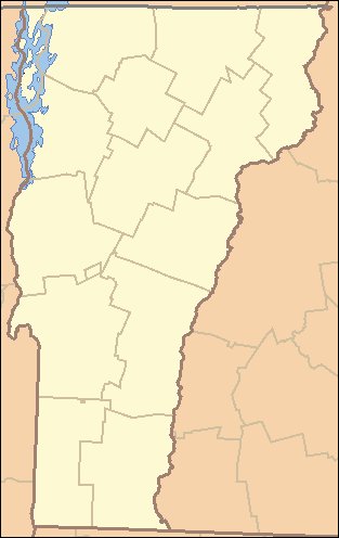
[3][5]Map Addison County 001 Middlebury 1785 Part of Rutland County. Joseph Addison (1672–1719), an English politician and writer. 36,821 770 sq mi
(1,995 km²)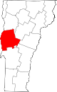
Bennington County 003 Bennington 1779 One of the original two counties. Benning Wentworth (1696–1770), the colonial governor of New Hampshire (1741–1766). 37,125 676 sq mi
(1,751 km2)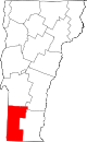
Caledonia County 005 St. Johnsbury 1792 Part of Orange County. Latin name for Scotland. 31,227 651 sq mi
(1,686 km2)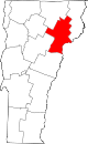
Chittenden County 007 Burlington 1787 Part of Addison County. Thomas Chittenden (1730–1797), first governor of Vermont (1791–1797). 156,545 539 sq mi
(1,396 km2)
Essex County 009 Guildhall 1792 Part of Orange County. Essex, a county in England. 6,306 665 sq mi
(1,722 km2)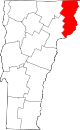
Franklin County 011 St. Albans (city) 1792 Part of Chittenden County. Benjamin Franklin (1706–1790), one of the most critical Founding Fathers of the United States. 47,746 637 sq mi
(1,650 km2)
Grand Isle County 013 North Hero 1802 Part of Chittenden County and Franklin County. Largest island in Lake Champlain. 6,970 83 sq mi
(215 km2)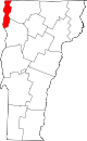
Lamoille County 015 Hyde Park 1835 Parts of Chittenden County, Franklin County, Orleans County and Washington County. La Mouelle (meaning the seagull), named by French explorer Samuel de Champlain (~1570–1635). 24,475 461 sq mi
(1,194 km2)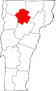
Orange County 017 Chelsea 1781 Part of Cumberland County. William of Orange (1650–1702), Prince of Orange. 28,936 689 sq mi
(1,785 km2)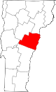
Orleans County 019 Newport (city) 1792 Part of Chittenden County and Orange County. City of Orléans, France. 27,231 697 sq mi
(1,805 km2)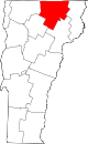
Rutland County 021 Rutland (city) 1781 Part of Bennington County. Town of Rutland, Massachusetts. 61,642 932 sq mi
(2,414 km2)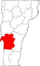
Washington County 023 Montpelier 1810 Parts of Orange County, Caledonia County, and Chittenden County. George Washington (1732–1799), first President of the United States (1789–1797). 59,534 690 sq mi
(1,787 km2)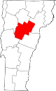
Windham County 025 Newfane 1779[a]
(as Cumberland County)
(renamed 1781)One of the original two counties. Town of Windham, Connecticut. 44,513 789 sq mi
(2,044 km2)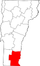
Windsor County 027 Woodstock 1781 Part of Cumberland County. Town of Windsor, Connecticut. 56,670 971 sq mi
(2,515 km2)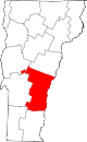
See also
- List of cities in Vermont
- List of gores in Vermont
- List of towns in Vermont
- List of extinct U.S. counties
Notes
- a There are several sources that state the formation year for Windham County is 1781 and that Cumberland County was dissolved rather than renamed.[6]
References
- ^ a b "Vermont County Information". Genealogy Trails. http://genealogytrails.com/ver/county_info.html. Retrieved 2007-07-22.
- ^ a b "EPA County FIPS Code Listing". EPA. http://www.epa.gov/enviro/html/codes/vt.html. Retrieved 2007-07-22.
- ^ a b c d "NACo - Find a county". National Association of Counties. Archived from the original on 2007-09-27. http://web.archive.org/web/20070927222753/http://www.naco.org/Template.cfm?Section=Find_a_County&Template=/cffiles/counties/state.cfm&state.cfm&statecode=VT. Retrieved 2007-07-22.
- ^ Kane, Joseph and Aiken, Charles (2004). The American Counties: Origins of County Names, Dates of Creation, and Population Data, 1950-2000. Scarecrow Press. ISBN 0810850362. http://books.google.com/books?id=yC9vFvCuW84C&pg=PA1&dq=Origins+of+County+Names#PPR24,M1.
- ^ a b "Vermont QuickFacts". U.S. Census Bureau. http://quickfacts.census.gov/qfd/maps/vermont_map.html. Retrieved 2007-07-23. (2000 Census)
- ^ "Vermont: Consolidated Chronology of State and County Boundaries". The Newberry Library. 2008. http://historical-county.newberry.org/website/Vermont/documents/VT_Consolidated_Chronology.htm. Retrieved 2009-06-03.
 State of Vermont
Regions Counties Addison · Bennington · Caledonia · Chittenden · Essex · Franklin · Grand Isle · Lamoille · Orange · Orleans · Rutland · Washington · Windham · Windsor
Metropolitan areas Burlington-South Burlington metropolitan area
Cities Barre · Burlington · Montpelier · Newport · Rutland · St. Albans · South Burlington · Vergennes · Winooski
Festivals Vermont State Fair · Green Mountain Film Festival
Topics Delegations · Constitution · Culture · Geography · Government · History · Images · People · Politics · Towns · Villages · Visitor Attractions
Categories:- Vermont counties
- Lists of U.S. counties by state
- Vermont-related lists


Wikimedia Foundation. 2010.