- List of counties in Oklahoma
-

This is a list of the 77 counties in the U.S. state of Oklahoma. Oklahoma is ranked 20th size and 17th in the number of counties, between Mississippi with 82 counties and Arkansas with 75 counties.[1]
Oklahoma originally had seven counties when it was first organized as the Oklahoma Territory. These counties were designated numerically, first through seventh. New counties added after this were designated by letters of the alphabet. The first seven counties were later renamed. The Oklahoma Constitutional Convention named all of the counties that were formed when Oklahoma entered statehood in 1907. Only two counties have been formed since then.[2]
According to the Oklahoma Constitution, a county can be disorganized if the sum of all taxable property is less than two and half million dollars. If so, then a petition must be signed by one-fourth of the population and then a vote would occur. If a majority vote for dissolution of the county, the county will combined with an adjacent county with the lowest valuation of taxable property.[3]
The Federal Information Processing Standard (FIPS) code, which is used by the United States government to uniquely identify counties, is provided with each entry. The FIPS code for each county links to census data for that county.
The Area in these tables is land area, and does not include water area.
Oklahoma's postal abbreviation is OK and its FIPS state code is 40.
Alphabetical list
County FIPS code
[4]County seat
[5]Established
[5]Origin Etymology
[6]Population
[7]Area
[5]Map Adair County 001 Stilwell 1907 Cherokee lands[8] William Penn Adair, Cherokee tribal leader and Confederate colonel in the American Civil War [8] 22,683 576 sq mi
(1,492 km2)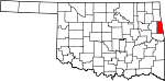
Alfalfa County 003 Cherokee 1907 Woods County William H. "Alfalfa Bill" Murray (1869-1956), ninth Governor of Oklahoma[9] 5,642 867 sq mi
(2,246 km2)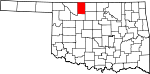
Atoka County 005 Atoka 1907 Choctaw lands Captain Atoka, a noted Choctaw leader and signer of the Treaty of Dancing Rabbit Creek[10] 14,182 978 sq mi
(2,533 km2)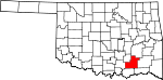
Beaver County 007 Beaver 1890 Seventh County (entire panhandle until 1907)[11] The Beaver River[12] 5,636 1,814 sq mi
(4,698 km2)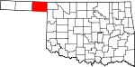
Beckham County 009 Sayre 1907 Greer County and Roger Mills County[13] J. C. W. Beckham (1869-1940), Governor of Kentucky[13] 22,119 902 sq mi
(2,336 km2)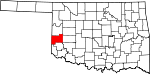
Blaine County 011 Watonga 1890 Part of Cheyenne and Arapaho reservation.[14] James G. Blaine (1830-1893), former Speaker of the United States House of Representatives, U.S. Senator and Secretary of State[15] 11,943 929 sq mi
(2,406 km2)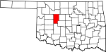
Bryan County 013 Durant 1907 Choctaw lands William Jennings Bryan (1860-1925), former Secretary of State, famous orator and three-time U.S. Presidential candidate[16] 42,416 909 sq mi
(2,354 km2)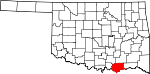
Caddo County 015 Anadarko 1901 Indian Territory From Indian word "Kaddi" meaning life or chief[17] 29,600 1,278 sq mi
(3,310 km2)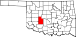
Canadian County 017 El Reno 1901 Part of Cheyenne and Arapaho reservation[18] The Canadian River.[19] 115,541 900 sq mi
(2,331 km2)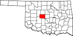
Carter County 019 Ardmore 1907 Pickens County, Chickasaw Nation A prominent family of early settlers[20] 47,557 824 sq mi
(2,134 km2)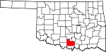
Cherokee County 021 Tahlequah 1907 Originally settled by Cherokee Indians following the Trail of Tears Cherokee Nation of Indians[21] 46,987 751 sq mi
(1,945 km2)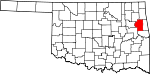
Choctaw County 023 Hugo 1907 . Choctaw Nation of Indians[22] 15,205 774 sq mi
(2,005 km2)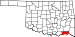
Cimarron County 025 Boise City 1907 Seventh County (entire panhandle until 1907)[11] Cimarron River[23] 2,475 1,835 sq mi
(4,753 km2)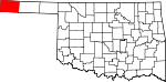
Cleveland County 027 Norman 1890 . Grover Cleveland (1837-1908), two-time President of the United States[24] 255,755 536 sq mi
(1,388 km2)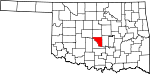
Coal County 029 Coalgate 1907 Tobucksy County, Choctaw Nation Coal, the primary economic product of the region at the time[25] 5,925 518 sq mi
(1,342 km2)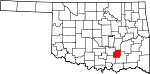
Comanche County 031 Lawton 1907 Kiowa, Comanche, and Apache reservation Spanish "Camino Ancho", meaning broad trail[26] 124,098 1,069 sq mi
(2,769 km2)
Cotton County 033 Walters 1912 Lands of Quapaws, Choctaws, Chickasaws, Comanche Reservation, and Big Pasture The principal economic base of the county, cotton[27] 6,193 637 sq mi
(1,650 km2)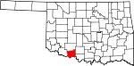
Craig County 035 Vinita 1907 Cherokee Nation Granville Craig, a prominent Cherokee planter[28] 15,029 761 sq mi
(1,971 km2)
Creek County 037 Sapulpa 1907 . Creek Nation of Indians[29] 69,967 956 sq mi
(2,476 km2)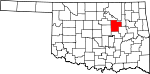
Custer County 039 Arapaho 1891 Cheyenne-Arapaho Reservation George Armstrong Custer (1839-1876), a United States Army cavalry commander during the Indian Wars[30] 27,469 987 sq mi
(2,556 km2)
Delaware County 041 Jay 1907 . Delaware Nation of Indians [2] 41,487 741 sq mi
(1,919 km2)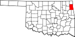
Dewey County 043 Taloga 1892 Cheyenne-Arapaho Reservation Admiral George Dewey (1837-1917), hero of the Spanish-American War [31] 4,810 1,000 sq mi
(2,590 km2)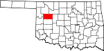
Ellis County 045 Arnett 1907 Roger Mills and Woodward counties Albert H. Ellis, vice president of the Oklahoma Constitutional Convention[32] (name could also be Abraham H. Ellis[2]) 4,151 1,229 sq mi
(3,183 km2)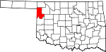
Garfield County 047 Enid 1893 Cherokee Outlet James Garfield (1831-1881), President of the United States[33] 60,580 1,058 sq mi
(2,740 km2)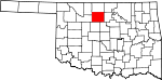
Garvin County 049 Pauls Valley 1907 Chickasaw Nation Samuel Garvin, a prominent Chickasaw Indian and local merchant[34] 27,576 809 sq mi
(2,095 km2)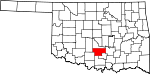
Grady County 051 Chickasha 1907 . Henry W. Grady (1851-1889), editor of the Atlanta Constitution newspaper[35] 52,431 1,101 sq mi
(2,852 km2)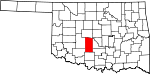
Grant County 053 Medford 1892 Originally "L" county Ulysses S. Grant (1822-1885), President of the United States[36] 4,527 1,001 sq mi
(2,593 km2)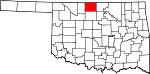
Greer County 055 Mangum 1896 Greer County, Texas John Alexander Greer, Lieutenant Governor of Texas[37] 6,239 639 sq mi
(1,655 km2)
Harmon County 057 Hollis 1909 Greer County Judson Harmon (1846-1927), U.S. Attorney General and Governor of Ohio[38] 2,922 538 sq mi
(1,393 km2)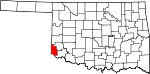
Harper County 059 Buffalo 1893 . Oscar G. Harper, clerk of the Oklahoma Constitutional Convention[39] 3,685 1,039 sq mi
(2,691 km2)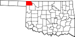
Haskell County 061 Stigler 1907 . Charles N. Haskell (1860-1933), first Governor of Oklahoma[40] 12,769 577 sq mi
(1,494 km2)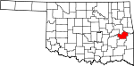
Hughes County 063 Holdenville 1907 . William C. Hughes, member of the Oklahoma Constitutional Convention[2][41] 14,003 807 sq mi
(2,090 km2)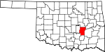
Jackson County 065 Altus 1907 Greer County Either Stonewall Jackson (1824-1863), Confederate general during the American Civil War[42] or Andrew Jackson (1767-1845), seventh President of the United States[2] 26,446 803 sq mi
(2,080 km2)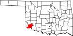
Jefferson County 067 Waurika 1907 Comanche County and part of Chickasaw Nation Thomas Jefferson (1743-1826), third President of the United States[43] 6,472 759 sq mi
(1,966 km2)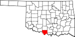
Johnston County 069 Tishomingo 1907 . Douglas H. Johnston, Governor of the Chickasaw Nation[44] 10,957 645 sq mi
(1,671 km2)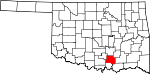
Kay County 071 Newkirk 1895 Cherokee Strip Originally designated as county "K"[45] 46,562 919 sq mi
(2,380 km2)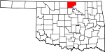
Kingfisher County 073 Kingfisher 1907 Unassigned Lands Either for the kingfisher brid[2] or King David Fisher, an early settler in the area[46] 15,034 903 sq mi
(2,339 km2)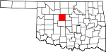
Kiowa County 075 Hobart 1901 Kiowa-Comanche-Apache Indian Reservations Kiowa Nation of Indians [47] 9,446 1,015 sq mi
(2,629 km2)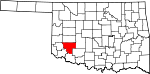
Latimer County 077 Wilburton 1907 . James S. Latimer, member of the Oklahoma Constitutional Convention[48] 11,154 722 sq mi
(1,870 km2)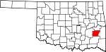
Le Flore County 079 Poteau 1907 Choctaw Nation[49] A Choctaw Indian family of French descent[2] 50,384 1,586 sq mi
(4,108 km2)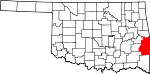
Lincoln County 081 Chandler 1891 . Abraham Lincoln, the sixteenth president of the United States 34,273 959 sq mi
(2,484 km2)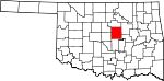
Logan County 083 Guthrie 1891 . John Alexander Logan, the American Civil War general 41,848 745 sq mi
(1,930 km2)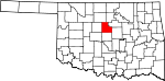
Love County 085 Marietta 1907 . Overton Love, a Chickasaw judge and prominent landowner 9,423 515 sq mi
(1,334 km2)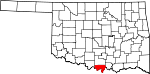
Major County 093 Fairview 1909 . John C. Major, member of the Oklahoma Constitutional Convention 7,527 957 sq mi
(2,479 km2)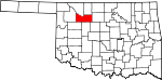
Marshall County 095 Madill 1907 . The maiden name of a member of the Constitutional Convention's mother 15,840 371 sq mi
(961 km2)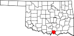
Mayes County 097 Pryor 1907 . Cherokee leader Samuel Houston Mayes 41,259 656 sq mi
(1,699 km2)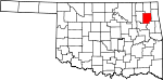
McClain County 087 Purcell 1907 . Charles M. McClain, member of the Oklahoma Constitutional Convention 34,506 570 sq mi
(1,476 km2)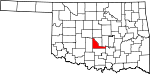
McCurtain County 089 Idabel 1907 . The McCurtain family, a prominent Choctaw landowning group 33,151 1,852 sq mi
(4,797 km2)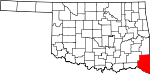
McIntosh County 091 Eufaula 1907 . The McIntosh family, a prominent Creek landowning group 20,252 620 sq mi
(1,606 km2)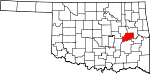
Murray County 099 Sulphur 1907 . Governor of Oklahoma William H. "Alfalfa Bill" Murray 13,488 418 sq mi
(1,083 km2)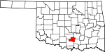
Muskogee County 101 Muskogee 1907 . Muskogee Nation of Indians 70,990 814 sq mi
(2,108 km2)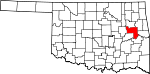
Noble County 103 Perry 1897 . U.S. Secretary of the Interior John W. Noble 11,561 732 sq mi
(1,896 km2)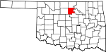
Nowata County 105 Nowata 1907 . The town of Nowata, Oklahoma. Its origin is unclear, but the two most common stories are that railroad surveyors used the Delaware word noweta for welcome or that a sign was posted indicating that local springs had no water: No wata 10,536 565 sq mi
(1,463 km2)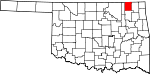
Okfuskee County 107 Okemah 1907 . Creek town of the same name in Cleburn County, Alabama 12,191 625 sq mi
(1,619 km2)
Oklahoma County 109 Oklahoma City 1891 . From two Choctaw words okla and humma, meaning people and red 718,633 709 sq mi
(1,836 km2)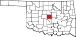
Okmulgee County 111 Okmulgee 1907 . Creek word meaning boiling water 40,069 697 sq mi
(1,805 km2)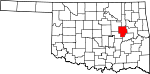
Osage County 113 Pawhuska 1907 . The Osage Indian Reservation, inhabited by the Osage Nation 47,472 2,251 sq mi
(5,830 km2)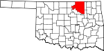
Ottawa County 115 Miami 1907 . Ottawa Native American people 31,848 471 sq mi
(1,220 km2)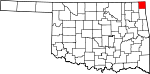
Pawnee County 117 Pawnee 1897 . The Skidi Pawnee Native American people 16,577 570 sq mi
(1,476 km2)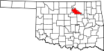
Payne County 119 Stillwater 1890 . David L. Payne, the key figure in opening Oklahoma to white settlement 77,350 686 sq mi
(1,777 km2)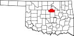
Pittsburg County 121 McAlester 1907 . Named for Pittsburgh, Pennsylvania 45,837 1,306 sq mi
(3,383 km2)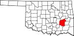
Pontotoc County 123 Ada 1907 . Pontotoc is a Chickasaw word meaning cat tails growing on the prairie 37,492 720 sq mi
(1,865 km2)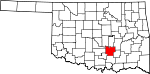
Pottawatomie County 125 Shawnee 1891 . The Pottawatomie Native American people 69,442 788 sq mi
(2,041 km2)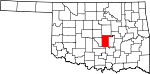
Pushmataha County 127 Antlers 1907 . The Pushmataha District of the Choctaw Nation 11,572 1,397 sq mi
(3,618 km2)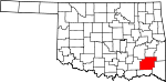
Roger Mills County 129 Cheyenne 1895 . U.S. Senator Roger Q. Mills 3,647 1,142 sq mi
(2,958 km2)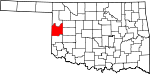
Rogers County 131 Claremore 1907 . Clem V. Rogers, a member of the Oklahoma Constitutional Convention and the father of entertainer Will Rogers 86,905 675 sq mi
(1,748 km2)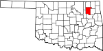
Seminole County 133 Wewoka 1907 . The Seminole Native American people 25,482 632 sq mi
(1,637 km2)
Sequoyah County 135 Sallisaw 1907 . Cherokee leader Sequoyah 42,391 674 sq mi
(1,746 km2)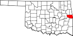
Stephens County 137 Duncan 1907 . John H. Stephens, a Texas congressman and advocate of Oklahoma statehood 45,048 877 sq mi
(2,271 km2)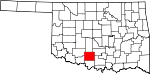
Texas County 139 Guymon 1907 Seventh County (entire panhandle until 1907)[11] The neighboring U.S. state of Texas 20,640 2,037 sq mi
(5,276 km2)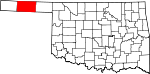
Tillman County 141 Frederick 1907 . U.S. Senator Benjamin Tillman of South Carolina 7,992 872 sq mi
(2,258 km2)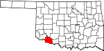
Tulsa County 143 Tulsa 1907 . The town of Tulsa, originally within the Creek Nation, Indian Territory, which in turn derives from Tulsey Town, Alabama, an old Creek settlement. 603,403 570 sq mi
(1,476 km2)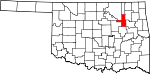
Wagoner County 145 Wagoner 1907 . Said to be named for Wagoner, Oklahoma, which in turn, was possibly named for Bailey P. Waggoner, attorney of the Missouri Pacific Railroad, the line around which the town was established 73,085 563 sq mi
(1,458 km2)
Washington County 147 Bartlesville 1907 . First President of the United States George Washington 50,976 417 sq mi
(1,080 km2)
Washita County 149 Cordell 1897 . The Washita River 11,629 1,004 sq mi
(2,600 km2)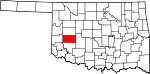
Woods County 151 Alva 1893 . Kansas populist and territorial legislator Samuel Newitt Wood 8,878 1,287 sq mi
(3,333 km2)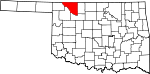
Woodward County 153 Woodward 1907 . Named for Santa Fe Railroad director B.W. Woodward 20,081 1,242 sq mi
(3,217 km2)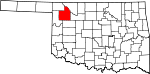
References
- ^ "How Many Counties are in Your State?". Click and Learn. http://www.clickandlearn.cc/FreeBlacklineMaps/Counties.htm. Retrieved 2009-08-26.
- ^ a b c d e f g "Origin of County Names in Oklahoma". Chronicles of Oklahoma 2 (1): 75–82. March 1924. http://digital.library.okstate.edu/Chronicles/v002/v002p075.html. Retrieved 2007-02-28.
- ^ "The Constitution of the State of Oklahoma," Article XVII, Section 5. http://oklegal.onenet.net/okcon/XVII-5.html. Accessed on 2007-02-28.
- ^ "EPA County FIPS Code Listing". EPA.gov. http://www.epa.gov/enviro/html/codes/ok.html. Retrieved 2008-02-23.
- ^ a b c National Association of Counties. "NACo - Find a county". http://www.uscounties.org/cffiles_web/counties/state.cfm?statecode=ok. Retrieved 2011-09-30.
- ^ Oklahoma Historical Society. "Origin of County Names in Oklahoma", Chronicles of Oklahoma 2:1 (March 1924) 75-82 (retrieved August 18, 2006)
- ^ "P1 Population Total - All counties within Oklahoma". US Census Bureau. 2010. http://factfinder2.census.gov/bkmk/table/1.0/en/DEC/10_SF1/P1/0400000US40.05000. Retrieved 2011-09-30.
- ^ a b Whitaker, Rachel, "Adair County," Encyclopedia of Oklahoma History and Culture (accessed June 21, 2010).
- ^ "Alfalfa" (PDF). Oklahoma Encyclopedia Online. Oklahoma Department of Libraries. 2005. http://www.odl.state.ok.us/almanac/2005/counties/alfalfa.pdf. Retrieved 2007-02-28.
- ^ "Atoka" (PDF). Oklahoma Encyclopedia Online. Oklahoma Department of Libraries. 2005. http://www.odl.state.ok.us/almanac/2005/counties/atoka.pdf. Retrieved 2007-02-28.
- ^ a b c Turner, Kenneth, "No Man's Land," Encyclopedia of Oklahoma History and Culture (accessed June 21, 2010).
- ^ "Beaver" (PDF). Oklahoma Encyclopedia Online. Oklahoma Department of Libraries. 2005. http://www.odl.state.ok.us/almanac/2005/counties/beaver.pdf. Retrieved 2007-02-28.
- ^ a b "Beckham" (PDF). Oklahoma Encyclopedia Online. Oklahoma Department of Libraries. 2005. http://www.odl.state.ok.us/almanac/2005/counties/beckham.pdf. Retrieved 2007-02-28.
- ^ Wilson, Linda D., "Blaine County," Encyclopedia of Oklahoma History and Culture (accessed June 21, 2010).
- ^ "Blaine" (PDF). Oklahoma Encyclopedia Online. Oklahoma Department of Libraries. 2005. http://www.odl.state.ok.us/almanac/2005/counties/blaine.pdf. Retrieved 2007-02-28.
- ^ "Bryan" (PDF). Oklahoma Encyclopedia Online. Oklahoma Department of Libraries. 2005. http://www.odl.state.ok.us/almanac/2005/counties/bryan.pdf. Retrieved 2007-02-28.
- ^ "Caddo" (PDF). Oklahoma Encyclopedia Online. Oklahoma Department of Libraries. 2005. http://www.odl.state.ok.us/almanac/2005/counties/caddo.pdf. Retrieved 2007-03-04.
- ^ "Canadian" (PDF). Oklahoma Encyclopedia Online. Oklahoma Department of Libraries. 2005. http://www.odl.state.ok.us/almanac/2005/counties/canadian.pdf. Retrieved 2007-03-04.
- ^ Oklahoma Historical Society. "Origin of County Names in Oklahoma", Chronicles of Oklahoma 2:1 (March 1924) 75-82 (retrieved August 18, 2006).
- ^ "Carter" (PDF). Oklahoma Encyclopedia Online. Oklahoma Department of Libraries. 2005. http://www.odl.state.ok.us/almanac/2005/counties/carter.pdf. Retrieved 2007-03-04.
- ^ "Cherokee" (PDF). Oklahoma Encyclopedia Online. Oklahoma Department of Libraries. 2005. http://www.odl.state.ok.us/almanac/2005/counties/cherokee.pdf. Retrieved 2007-03-04.
- ^ "Choctaw" (PDF). Oklahoma Encyclopedia Online. Oklahoma Department of Libraries. 2005. http://www.odl.state.ok.us/almanac/2005/counties/choctaw.pdf. Retrieved 2007-03-04.
- ^ "Cimarron" (PDF). Oklahoma Encyclopedia Online. Oklahoma Department of Libraries. 2005. http://www.odl.state.ok.us/almanac/2005/counties/cimarron.pdf. Retrieved 2007-03-04.
- ^ "Cleveland" (PDF). Oklahoma Encyclopedia Online. Oklahoma Department of Libraries. 2005. http://www.odl.state.ok.us/almanac/2005/counties/cleveland.pdf. Retrieved 2007-03-04.
- ^ "Coal" (PDF). Oklahoma Encyclopedia Online. Oklahoma Department of Libraries. 2005. http://www.odl.state.ok.us/almanac/2005/counties/coal.pdf. Retrieved 2007-03-04.
- ^ "Comanche" (PDF). Oklahoma Encyclopedia Online. Oklahoma Department of Libraries. 2005. http://www.odl.state.ok.us/almanac/2005/counties/comanche.pdf. Retrieved 2007-03-04.
- ^ "Cotton" (PDF). Oklahoma Encyclopedia Online. Oklahoma Department of Libraries. 2005. http://www.odl.state.ok.us/almanac/2005/counties/cotton.pdf. Retrieved 2007-03-04.
- ^ "Craig" (PDF). Oklahoma Encyclopedia Online. Oklahoma Department of Libraries. 2005. http://www.odl.state.ok.us/almanac/2005/counties/craig.pdf. Retrieved 2007-03-04.
- ^ "Creek" (PDF). Oklahoma Encyclopedia Online. Oklahoma Department of Libraries. 2005. http://www.odl.state.ok.us/almanac/2005/counties/creek.pdf. Retrieved 2007-03-04.
- ^ "Custer" (PDF). Oklahoma Encyclopedia Online. Oklahoma Department of Libraries. 2005. http://www.odl.state.ok.us/almanac/2005/counties/custer.pdf. Retrieved 2007-03-04.
- ^ "Dewey" (PDF). Oklahoma Encyclopedia Online. Oklahoma Department of Libraries. 2005. http://www.odl.state.ok.us/almanac/2005/counties/dewey.pdf. Retrieved 2007-03-04.
- ^ "Ellis" (PDF). Oklahoma Encyclopedia Online. Oklahoma Department of Libraries. 2005. http://www.odl.state.ok.us/almanac/2005/counties/ellis.pdf. Retrieved 2007-03-04.
- ^ "Garfield" (PDF). Oklahoma Encyclopedia Online. Oklahoma Department of Libraries. 2005. http://www.odl.state.ok.us/almanac/2005/counties/garfield.pdf. Retrieved 2007-03-04.
- ^ "Garvin" (PDF). Oklahoma Encyclopedia Online. Oklahoma Department of Libraries. 2005. http://www.odl.state.ok.us/almanac/2005/counties/garvin.pdf. Retrieved 2007-03-04.
- ^ "Grady" (PDF). Oklahoma Encyclopedia Online. Oklahoma Department of Libraries. 2005. http://www.odl.state.ok.us/almanac/2005/counties/grady.pdf. Retrieved 2007-03-04.
- ^ "Grant" (PDF). Oklahoma Encyclopedia Online. Oklahoma Department of Libraries. 2005. http://www.odl.state.ok.us/almanac/2005/counties/grant.pdf. Retrieved 2007-03-04.
- ^ "Greer" (PDF). Oklahoma Encyclopedia Online. Oklahoma Department of Libraries. 2005. http://www.odl.state.ok.us/almanac/2005/counties/greer.pdf. Retrieved 2007-03-04.
- ^ "Harmon" (PDF). Oklahoma Encyclopedia Online. Oklahoma Department of Libraries. 2005. http://www.odl.state.ok.us/almanac/2005/counties/harmon.pdf. Retrieved 2007-03-04.
- ^ "Harper" (PDF). Oklahoma Encyclopedia Online. Oklahoma Department of Libraries. 2005. http://www.odl.state.ok.us/almanac/2005/counties/harper.pdf. Retrieved 2007-04-02.
- ^ "Haskell" (PDF). Oklahoma Encyclopedia Online. Oklahoma Department of Libraries. 2005. http://www.odl.state.ok.us/almanac/2005/counties/haskell.pdf. Retrieved 2007-04-02.
- ^ "Hughes" (PDF). Oklahoma Encyclopedia Online. Oklahoma Department of Libraries. 2005. http://www.odl.state.ok.us/almanac/2005/counties/hughes.pdf. Retrieved 2007-04-02.
- ^ "Jackson" (PDF). Oklahoma Encyclopedia Online. Oklahoma Department of Libraries. 2005. http://www.odl.state.ok.us/almanac/2005/counties/jackson.pdf. Retrieved 2007-04-02.
- ^ "Jefferson" (PDF). Oklahoma Encyclopedia Online. Oklahoma Department of Libraries. 2005. http://www.odl.state.ok.us/almanac/2005/counties/jefferson.pdf. Retrieved 2007-04-02.
- ^ "Johnston" (PDF). Oklahoma Encyclopedia Online. Oklahoma Department of Libraries. 2005. http://www.odl.state.ok.us/almanac/2005/counties/johnston.pdf. Retrieved 2007-04-02.
- ^ "Kay" (PDF). Oklahoma Encyclopedia Online. Oklahoma Department of Libraries. 2005. http://www.odl.state.ok.us/almanac/2005/counties/kay.pdf. Retrieved 2007-04-02.
- ^ "Kingfisher" (PDF). Oklahoma Encyclopedia Online. Oklahoma Department of Libraries. 2005. http://www.odl.state.ok.us/almanac/2005/counties/kingfisher.pdf. Retrieved 2007-04-02.
- ^ "Kiowa" (PDF). Oklahoma Encyclopedia Online. Oklahoma Department of Libraries. 2005. http://www.odl.state.ok.us/almanac/2005/counties/kiowa.pdf. Retrieved 2007-04-02.
- ^ "Latimer" (PDF). Oklahoma Encyclopedia Online. Oklahoma Department of Libraries. 2005. http://www.odl.state.ok.us/almanac/2005/counties/latimer.pdf. Retrieved 2007-04-02.
- ^ "Le Flore" (PDF). Oklahoma Encyclopedia Online. Oklahoma Department of Libraries. 2005. http://www.odl.state.ok.us/almanac/2005/counties/leflore.pdf. Retrieved 2007-04-02.
See also
List of U.S. counties and county-equivalents
by political division (state / federal district)- Alabama
- Alaska
- Arizona
- Arkansas
- California
- Colorado
- Connecticut
- Delaware
- District of Columbia
- Florida
- Georgia
- Hawaii
- Idaho
- Illinois
- Indiana
- Iowa
- Kansas
- Kentucky
- Louisiana
- Maine
- Maryland
- Massachusetts
- Michigan
- Minnesota
- Mississippi
- Missouri
- Montana
- Nebraska
- Nevada
- New Hampshire
- New Jersey
- New Mexico
- New York
- North Carolina
- North Dakota
- Ohio
- Oklahoma
- Oregon
- Pennsylvania
- Rhode Island
- South Carolina
- South Dakota
- Tennessee
- Texas
- Utah
- Vermont
- Virginia
- Washington
- West Virginia
- Wisconsin
- Wyoming
Categories:- Lists of U.S. counties by state
- Oklahoma counties


Wikimedia Foundation. 2010.