- The Bahamas
-
This article is about the country. For the Canadian singer-guitarist, see Bahamas (musician).
Commonwealth of the Bahamas 
Flag Coat of arms Motto: "Forward, Upward, Onward, Together" Anthem: "March On, Bahamaland"
Royal anthem: "God Save the Queen"
Capital
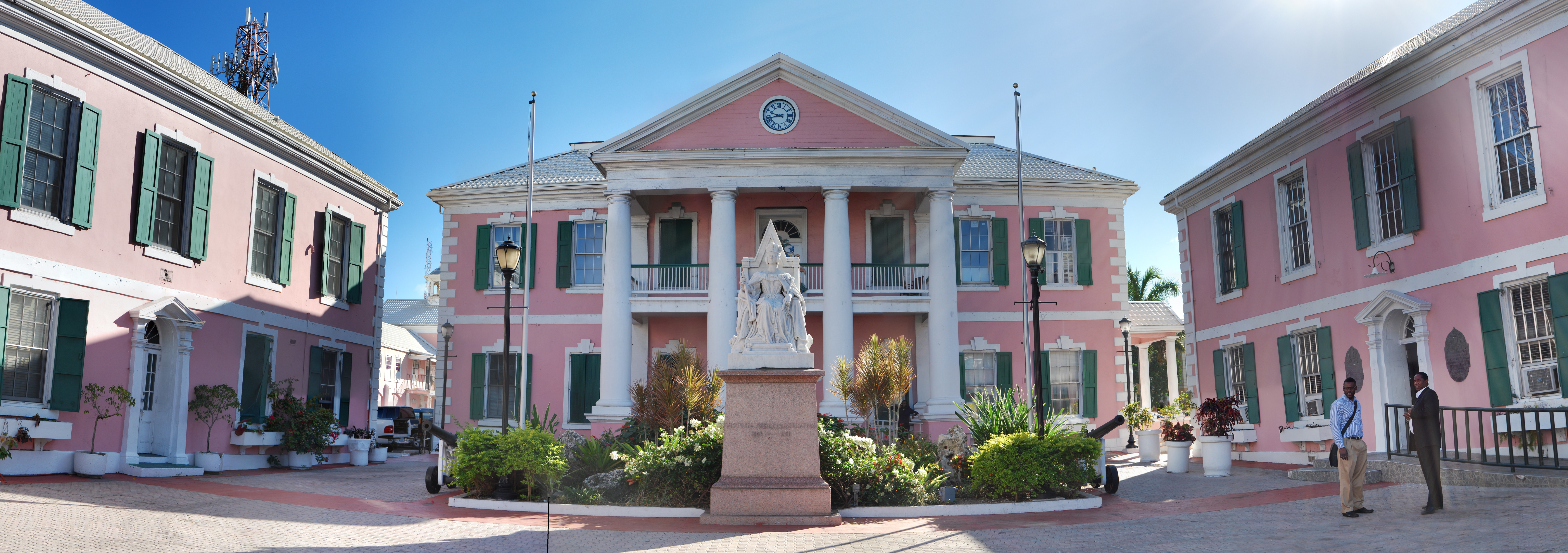
(and largest city)Nassau
25°4′N 77°20′W / 25.067°N 77.333°WOfficial language(s) English Recognised regional languages Bahamian Dialect Ethnic groups 85% African Bahamians, 12% European Bahamians, 3% Asians and Hispanic[1] Demonym Bahamian Government Unitary Parliamentary democracy and Constitutional monarchy.[2][3] - Monarch Elizabeth II - Governor-General Sir Arthur Foulkes - Prime Minister Hubert Ingraham Legislature Parliament - Upper House Senate - Lower House House of Assembly Independence - from the United Kingdom July 10, 1973[4] Area - Total 13,878 km2 (160th)
5,358 sq mi- Water (%) 28% Population - 2010 estimate 353,658[5] (177th) - 1990 census 254,685 - Density 23.27/km2 (181st)
60/sq miGDP (PPP) 2010 estimate - Total $8.921 billion[6] - Per capita $25,894[6] GDP (nominal) 2010 estimate - Total $7.538 billion[6] - Per capita $21,878[6] HDI (2010)  0.784[7] (very high) (43rd)
Currency Bahamian dollar ( BSD)Time zone EST (UTC−5) - Summer (DST) EDT (UTC−4) Drives on the left Internet TLD .bs Calling code +1-242 The Bahamas
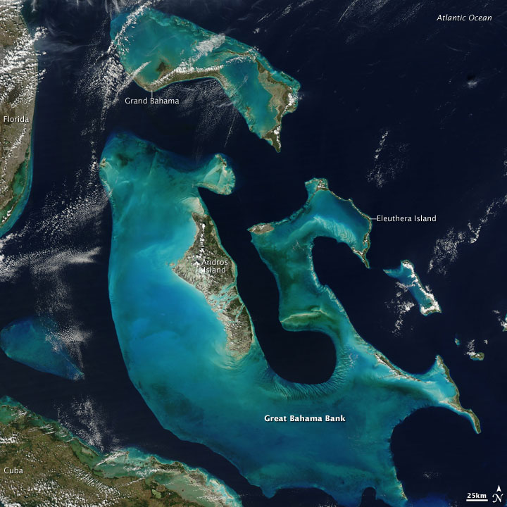
 i/bəˈhɑːməz/, officially the Commonwealth of the Bahamas, is a nation consisting of 29 islands, 661 cays, and 2,387 islets (rocks). It is located in the Atlantic Ocean north of Cuba and Hispaniola (Dominican Republic and Haiti), northwest of the Turks and Caicos Islands, and southeast of the United States (nearest to the state of Florida). Its land area is 13,939 km2 (5,382 sq mi), with a population of 353,658. Its capital is Nassau. Geographically, The Bahamas lie in the same island chain as Cuba, Hispaniola and the Turks and Caicos Islands; the designation of Bahamas refers normally to the Commonwealth and not the geographic chain.
Originally inhabited by the Lucayans, a branch of the Arawakan-speaking Taino people, The Bahamas were the site of Columbus' first landfall in the New World in 1492. Although the Spanish never colonized The Bahamas, they shipped the native Lucayans to slavery in Hispaniola. The islands were mostly deserted from 1513 to 1648, when English colonists from Bermuda settled on the island of Eleuthera.
The Bahamas became a Crown Colony in 1718 when the British clamped down on piracy. Following the American War of Independence, thousands of pro-British loyalists and enslaved Africans moved to The Bahamas and set up a plantation economy. The slave trade was abolished in the British Empire in 1807 and many Africans liberated from slave ships by the Royal Navy were settled in The Bahamas during the 19th century. Slavery itself was abolished in 1834 and the descendants of enslaved and liberated Africans form the bulk of The Bahamas's population today.
In terms of GDP, the Bahamas is one of the richest countries in the Americas, (following Bermuda, The United States, Cayman Islands, Canada, and The British Virgin Islands)[8] and one of the richest in the world whose population is predominantly of African ancestry.[9] [10]
Contents
Etymology
The origin of the name Bahamas is unclear. It may derive from the Spanish baja mar ("low sea") or the Lucayan word for Grand Bahama island, ba-ha-ma ("large upper middle land").[11]
History
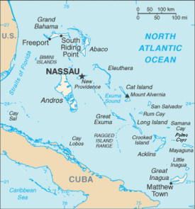 Map of The Bahamas
 Main article: History of The Bahamas
Taino people moved into the uninhabited southern Bahamas from Hispaniola and Cuba around the 11th century AD. These people came to be known as the Lucayans. There were an estimated 30,000+ Lucayans at the time of Columbus's arrival in 1492. Christopher Columbus's first landfall in the New World was on an island named San Salvador (known to the Lucayans as Guanahani), which some researchers believe to be present-day San Salvador Island, (also known as Watling's Island) in the southeastern Bahamas.
An alternative theory holds that Columbus landed to the southeast on Samana Cay, according to calculations made in 1986 by National Geographic writer and editor Joseph Judge based on Columbus's log. Evidence in support of this remains inconclusive. On the landfall island, Columbus made first contact with the Lucayans and exchanged goods with them.
The Lucayans throughout The Bahamas were wiped out as a result of Spanish forced migration of the population to Hispaniola for use as forced labour there, and exposure to diseases to which they had no immunity.[12] The smallpox that ravaged the Taino Indians after Columbus's arrival wiped out half of the population in what is now The Bahamas.[13]
It is generally assumed that the islands were uninhabited by Europeans until the mid-17th century. However, recent research suggests that there may have been attempts to settle the islands by groups from Spain, France, and Britain, as well as by other Amerindians. In 1648, the Eleutherian Adventurers migrated from Bermuda. These English Puritans established the first permanent European settlement on an island which they named Eleuthera—the name derives from the Greek word for freedom. They later settled New Providence, naming it Sayle's Island after one of their leaders. To survive, the settlers resorted to salvaged goods from wrecks.
In 1670 King Charles II granted the islands to the Lords Proprietors of the Carolinas, who rented the islands from the king with rights of trading, tax, appointing governors, and administering the country.[14] In 1684 Spain's corsair Juan de Alcon raided the capital Charles Town, and in 1703 a joint Franco-Spanish expedition briefly occupied the Bahamian capital during the War of the Spanish Succession.
18th century
During proprietary rule, The Bahamas became a haven for pirates, including the infamous Blackbeard. To restore orderly government, The Bahamas were made a British crown colony in 1718 under the royal governorship of Woodes Rogers, who, after a difficult struggle, succeeded in suppressing piracy.[15] In 1720, Rogers led local militia to drive off a Spanish attack.
During the American War of Independence, the islands were a target for American naval forces under the command of Commodore Ezekial Hopkins. The capital of Nassau on the island of New Providence was occupied by US Marines for a fortnight.
In 1782, following the British defeat at Yorktown, a Spanish fleet appeared off the coast of Nassau, and the city surrendered without a fight.
After American independence, some 7,300 Loyalists and their slaves moved to The Bahamas from New York, Florida, and The Carolinas. These Loyalists established plantations on several islands and became a political force in the capital. The small population became mostly African from this point on.
The British abolished the slave trade in 1807, which led to the forced settlement on Bahamian islands of thousands of Africans liberated from slave ships by the Royal Navy. Slavery itself was finally abolished in the British Empire on August 1, 1834.
20th century
Modern political development began after the Second World War. The first political parties were formed in the 1950s and the British made the islands internally self-governing in 1964, with Sir Roland Symonette of the United Bahamian Party as the first premier.
In 1967, Sir Lynden Pindling of the Progressive Liberal Party became the first black premier of the colony, and in 1968 the title was changed to prime minister. In 1973, The Bahamas became fully independent, but retained membership in the Commonwealth of Nations. Sir Milo Butler was appointed the first Bahamian governor-general (the representative of Queen Elizabeth II) shortly after independence.
Based on the twin pillars of tourism and offshore finance, the Bahamian economy has prospered since the 1950s. However, there remain significant challenges in areas such as education, health care, housing, international narcotics trafficking and illegal immigration from Haiti.
Geography and climate
Main article: Geography of The BahamasThe country lies between latitudes 20° and 28°N, and longitudes 72° and 80°W.
The closest island to the United States is Bimini, which is also known as the gateway to The Bahamas. The island of Abaco is to the east of Grand Bahama. The southeasternmost island is Inagua. The largest island is Andros Island. Other inhabited islands include Eleuthera, Cat Island, Long Island, San Salvador Island, Acklins, Crooked Island, Exuma and Mayaguana. Nassau, capital city of The Bahamas, lies on the island of New Providence.
All the islands are low and flat, with ridges that usually rise no more than 15 to 20 m (49 to 66 ft). The highest point in the country is Mount Alvernia, formerly called Como Hill, which has an altitude of 63 metres (207 ft) on Cat Island.
To the southeast, the Turks and Caicos Islands, and three more extensive submarine features called Mouchoir Bank, Silver Bank, and Navidad Bank, are geographically a continuation of The Bahamas, but not part of the Commonwealth of The Bahamas.[citation needed]
Climate
See also: Geography of the BahamasThe climate of The Bahamas is subtropical to tropical, and is moderated significantly by the waters of the Gulf Stream, particularly in winter.[16] Conversely, this often proves very dangerous in the summer and autumn, when hurricanes pass near or through the islands. Hurricane Andrew hit the northern islands during the 1992 Atlantic hurricane season, and Hurricane Floyd hit most of the islands during the 1999 Atlantic hurricane season.
While there has never been a freeze reported in The Bahamas, the temperature can fall as low as 2–3 °C (35.6–37.4 °F) during Arctic outbreaks that affect nearby Florida. Snow was reported to have mixed with rain in Freeport in January 1977, the same time that it snowed in the Miami area.[17] The temperature was about 4.5 °C (40.1 °F) at the time.[18]
Climate data for Nassau, Bahamas Month Jan Feb Mar Apr May Jun Jul Aug Sep Oct Nov Dec Year Average high °C (°F) 25.4
(77.7)25.5
(77.9)26.6
(79.9)27.9
(82.2)29.7
(85.5)31.0
(87.8)32.0
(89.6)32.1
(89.8)31.6
(88.9)29.9
(85.8)27.8
(82.0)26.2
(79.2)28.8 Daily mean °C (°F) 21.4
(70.5)21.4
(70.5)22.3
(72.1)23.8
(74.8)25.6
(78.1)27.2
(81.0)28.0
(82.4)28.1
(82.6)27.7
(81.9)26.2
(79.2)24.2
(75.6)22.3
(72.1)24.8 Average low °C (°F) 17.3
(63.1)17.3
(63.1)17.9
(64.2)19.6
(67.3)21.4
(70.5)23.3
(73.9)24.0
(75.2)24.0
(75.2)23.7
(74.7)22.5
(72.5)20.6
(69.1)18.3
(64.9)20.8 Precipitation mm (inches) 39.4
(1.551)49.5
(1.949)54.4
(2.142)69.3
(2.728)105.9
(4.169)218.2
(8.591)160.8
(6.331)235.7
(9.28)164.1
(6.461)161.8
(6.37)80.5
(3.169)49.8
(1.961)1,389.4
(54.701)Avg. precipitation days 8 6 7 8 10 15 17 19 17 15 10 8 140 Sunshine hours 220.1 220.4 257.3 276.0 269.7 231.0 272.8 266.6 213.0 223.2 222.0 213.9 2,886 Source: World Meteorological Organization (UN),[19] Hong Kong Observatory[20] for data of sunshine hours Government and politics
Main article: Politics of The Bahamas
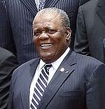 Prime Minister Hubert Ingraham
The Bahamas is a sovereign, independent, nation. Political and legal traditions closely follow those of the United Kingdom and the Westminster system. The Bahamas is a parliamentary democracy with two main parties, the Free National Movement and the Progressive Liberal Party.
Tourism generates about half of all jobs, but the number of visitors has dropped significantly since the beginning of the global economic downturn during the last quarter of 2008. Banking and international financial services also have contracted, and The Bahamas is one of 34 secrecy jurisdictions that would be subject to the Stop Tax Haven Abuse Act introduced in the U.S. Congress.
The Bahamas is a member of the Commonwealth of Nations, and a Commonwealth realm with Queen Elizabeth II as head of state (represented by a Governor-General).
Legislative power is vested in a bicameral parliament, which consists of a 41-member House of Assembly (the lower house), with members elected from single-member districts, and a 16-member Senate, with members appointed by the governor-general, including nine on the advice of the prime minister, four on the advice of the leader of the opposition, and three on the advice of the prime minister after consultation with the leader of the opposition. The House of Assembly carries out all major legislative functions. As under the Westminster system, the prime minister may dissolve parliament and call a general election at any time within a five-year term.
The Prime Minister is the head of government and is the leader of the party with the most seats in the House of Assembly. Executive power is exercised by the cabinet, selected by the prime minister and drawn from his supporters in the House of Assembly. The current governor-general is Sir Arthur Foulkes and the current Prime Minister is Hubert Ingraham.
The Bahamas has a largely two-party system dominated by the centre-left Progressive Liberal Party and the centre-right Free National Movement. A handful of splinter parties have been unable to win election to parliament. These parties have included the Bahamas Democratic Movement, the Coalition for Democratic Reform and the Bahamian Nationalist Party.
Constitutional safeguards include freedom of speech, press, worship, movement, and association. Although The Bahamas is not geographically located in the Caribbean, it is a member of the Caribbean Community. The judiciary is independent of the executive and the legislature. Jurisprudence is based on English law.
Administrative divisions
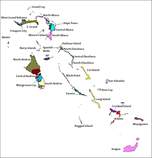 Districts of The BahamasMain article: Local government in the Bahamas
The districts of The Bahamas provide a system of local government everywhere except New Providence, whose affairs are handled directly by the central government. In 1996, the Bahamian Parliament passed "The Local Government Act" to facilitate the establishment of Family Island Administrators, Local Government Districts, Local District Councillors, and Local Town Committees for the various island communities. The overall goal of this act is to allow the various elected leaders to govern and oversee the affairs of their respective districts without the interference of Central Government. In total, there are 32 districts, with elections being held every three years. There are also one hundred and ten Councillors and two hundred and eighty-one Town Committee members to correspond with the various districts.[21]
Each Councillor or Town Committee member is responsible for the proper use of public funds for the maintenance and development of their constituency.
The districts other than New Providence are:
- Mangrove Cay, Andros
- Mayaguana
- Moore's Island, Abaco
- North Abaco
- North Andros
- North Eleuthera
- Ragged Island
- Rum Cay
- San Salvador
- South Abaco
- South Andros
- South Eleuthera
- Spanish Wells, Eleuthera
- West Grand Bahama
- Green Turtle Cay (not shown on map on the right)
Military
Main article: Royal Bahamas Defence ForceThe Bahamas does not have an army or an air force. Its military is composed of the Royal Bahamas Defence Force (RBDF), the navy of The Bahamas. Under The Defence Act, the Royal Bahamas Defence Force has been mandated to defend The Bahamas, protect its territorial integrity, patrol its waters, provide assistance and relief in times of disaster, maintain order in conjunction with the law enforcement agencies of The Bahamas, and carry out any such duties as determined by the National Security Council. The Defence Force is also a member of Caricom's Regional Security Task Force.
The Royal Bahamas Defence Force officially came into existence on March 31, 1980. Their duties include defending the Bahamas, stopping drug smuggling, illegal immigration, poaching, and providing assistance to mariners whenever and wherever they can. The Defence Force has a fleet of 26 coastal and inshore patrol craft along with 2 aircraft and over 850 personnel including 65 officers and 74 women.
National symbols
National flag
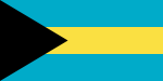 National Flag of The Bahamas
The colors embodied in the design of the Bahamian flag symbolise the image and aspirations of the people of The Bahamas; the design reflects aspects of the natural environment (sun, sand, and sea) and the economic and social development. The flag is a black equilateral triangle against the mast, superimposed on a horizontal background made up of two colours on three equal stripes of aquamarine, gold and aquamarine.
The symbolism of the flag is as follows: Black, a strong colour, represents the vigour and force of a united people, the triangle pointing towards the body of the flag represents the enterprise and determination of the Bahamian people to develop and possess the rich resources of sun and sea symbolized by gold and aquamarine respectively. In reference to the representation of the people with the colour black, some white Bahamians have joked that they are represented in the thread which "holds it all together."[22]
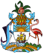
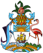 Bahamian Coat of Arms
Coat of arms
Main article: Coat of arms of The BahamasThe Coat of Arms of The Bahamas contains a shield with the national symbols as its focal point. The shield is supported by a marlin and a flamingo, which are the national animals of The Bahamas. The flamingo is located on the land, and the marlin on the sea, indicating the geography of the islands.
On top of the shield is a conch shell, which represents the varied marine life of the island chain. The conch shell rests on a helmet. Below this is the actual shield, the main symbol of which is a ship representing the Santa María of Christopher Columbus, shown sailing beneath the sun. Along the bottom, below the shield appears a banner upon which is scripted the national motto:[23]
"Forward, Upward, Onward Together."
 The yellow elder
National flower
The yellow elder was chosen as the national flower of The Bahamas because it is native to the Bahama Islands, and it blooms throughout the year.
Selection of the yellow elder over many other flowers was made through the combined popular vote of members of all four of New Providence's garden clubs of the 1970s – the Nassau Garden Club, the Carver Garden Club, the International Garden Club, and the YWCA Garden Club.
They reasoned that other flowers grown there – such as the bougainvillea, hibiscus, and poinciana – had already been chosen as the national flowers of other countries. The yellow elder, on the other hand, was unclaimed by other countries (although it is now also the national flower of the United States Virgin Islands).[24]
Economy
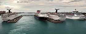 Cruise ships in Nassau HarbourMain article: Economy of The Bahamas
One of the most prosperous countries in the Caribbean region, The Bahamas relies on tourism to generate most of its economic activity. Tourism as an industry not only accounts for over 60 percent of the Bahamian GDP, but provides jobs for more than half the country's workforce.[25] After tourism, the next most important economic sector is financial services, accounting for some 15 percent of GDP.
The government has adopted incentives to encourage foreign financial business, and further banking and finance reforms are in progress. The government plans to merge the regulatory functions of key financial institutions, including the Central Bank of The Bahamas (CBB) and the Securities and Exchange Commission.[citation needed] The Central Bank administers restrictions and controls on capital and money market instruments. The Bahamas International Securities Exchange currently consists of 19 listed public companies. Reflecting the relative soundness of the banking system (mostly populated by Canadian banks), the impact of the global financial crisis on the financial sector has been limited.[citation needed]
The economy has a very competitive tax regime. The government derives its revenue from import tariffs, license fees, property and stamp taxes, but there is no income tax, corporate tax, capital gains tax, value-added tax (VAT), or wealth tax. Payroll taxes fund social insurance benefits. In the most recent year, Overall tax revenue as a percentage of GDP is 21.8 percent.[citation needed] Authorities are trying to increase tax compliance and collection in the wake of the global crisis. Inflation has been moderate, averaging 3.7 percent between 2006 and 2008.[citation needed]
By the terms of GDP per capita, the Bahamas is one of the richest countries in the Americas.[26]
Ethnic groups
Main article: Demographics of The BahamasAfro-Bahamians
Afro-Bahamians or Bahamians of African descent are Bahamians whose ancestry lies within the continent of Africa, most notably West Africa. The first Africans to arrive to The Bahamas came from Bermuda with the Eleutheran Adventurers as freed slaves looking for a new life. Currently, Afro-Bahamians are the largest ethnic group in The Bahamas, accounting for some 85% of the country's population.[27]
Europeans
European Bahamians, or Bahamians of European descent, numbering about 38,000,[28] are mainly the descendants of the British Puritans and American Loyalists who arrived in 1649 and 1783 respectively. They form the largest minority group in The Bahamas making up some 12% of the population.[29]
A small portion of the European Bahamian population is descended from Greek labourers who came to help develop the sponging industry in the 1900s. Although making up less than 1% of the nation's population, they have been able to preserve their distinct Greek culture.[citation needed]
One of the most interesting, if sometimes confusing features of the Bahamian genealogy is that most families have branches, and even immediate family members, spanning the entire spectrum between ‘ light’, 'brown' and ‘unequivocally dark.’ [30]
Demographics
- Population: 354,563
- Age structure: 0–14 years: 25.9% (male 40,085; female 38,959)
- 15–64 years: 67.2% (male 102,154; female 105,482)
- 65 years and over: 6.9% (male 8,772; female 12,704) (2009 est.)
- Population growth rate: 0.925% (2010 est.)[31]
- Birth rate: 17.81 births/1,000 population (2010 est.)
- Death rate: 9.35 deaths/1,000 population (July 2010 est.)
- Net migration rate: -2.13 migrant(s)/1,000 population (2010 est.)
- Infant mortality rate: 23.21 deaths/1,000 live births (2010 est.)
- Life expectancy at birth: total population: 69.87 years.
- Female: 73.49 years (2002 est.)
- Male: 66.32 years
- Total fertility rate: 2.0 children born/woman (2010 est.)[32]
- Nationality: noun: Bahamian(s)
- Adjective: Bahamian /bəˈheɪmiən/
- Ethnic groups: African 85%, European 12%, Asian and Mestizo 3% (Roughly 1.5% each).[1]
- Religions: Baptist 35.4%, Anglican 15.1%, Roman Catholic 13.5%, Pentecostal 8.1%, Church of God 4.8%, Methodist 4.2%, other Christian 15.2%,[1] other Protestant 12%, none or unknown 3%, other 2%[33] The 'other' category includes Jews, Muslims, Baha'is, Hindus, Rastafarians, and practitioners of Obeah.[34]
- Languages: English (official), Bahamian dialect [35]
- Literacy (age 15+): total population: 98.2%
- male: 98.5%
- female: 98% (1995 est.)[36]
Culture
Main articles: Culture of The Bahamas and Music of The BahamasIn the less developed outer islands, handicrafts include basketry made from palm fronds. This material, commonly called "straw", is plaited into hats and bags that are popular tourist items. Another use is for so-called "Voodoo dolls," even though such dolls are the result of the American imagination and not based on historic fact.[37]
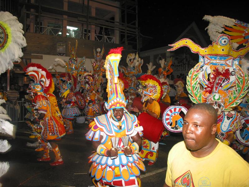
Although not practised by native Bahamians, a form of folk magic obeah derived from West African origins, is practiced in some Family Islands (out-islands) of The Bahamas due to Haitian migration. The practice of obeah is however illegal in The Bahamas and punishable by law.[38] Junkanoo is a traditional African street parade of music, dance, and art held in Nassau (and a few other settlements) every Boxing Day, New Year's Day. Junkanoo is also used to celebrate other holidays and events such as Emancipation Day.
Regattas are important social events in many family island settlements. They usually feature one or more days of sailing by old-fashioned work boats, as well as an onshore festival.
Some settlements have festivals associated with the traditional crop or food of that area, such as the "Pineapple Fest" in Gregory Town, Eleuthera or the "Crab Fest" on Andros. Other significant traditions include story telling.
See also
- Outline of the Bahamas[
- Bibliography of the Bahamas
- Index of Bahamas-related articles
- List of Bahamas-related topics
- List of Bahamians
- Lucayan Archipelago
- Transport in the Bahamas
- Member of
References
- ^ a b c https://www.cia.gov/library/publications/the-world-factbook/geos/bf.html
- ^ "•GENERAL SITUATION AND TRENDS". Pan American Health Organization. http://www.paho.org/english/dd/ais/cp_044.htm.
- ^ "Mission to Long Island in the Bahamas". Evangelical Association of the Caribbean. http://www.caribbeanevangelical.org/newsevents/oldarticles.htm?id=82.
- ^ "1973: Bahamas' sun sets on British Empire". BBC News. July 9, 1973. http://news.bbc.co.uk/onthisday/hi/dates/stories/july/9/newsid_2498000/2498835.stm. Retrieved 2009-05-01.
- ^ COMPARISON BETWEEN THE 2000 AND 2010 POPULATION CENSUSES AND PERCENTAGE CHANGE.
- ^ a b c d "The Bahamas". International Monetary Fund. http://www.imf.org/external/pubs/ft/weo/2011/01/weodata/weorept.aspx?pr.x=99&pr.y=5&sy=2008&ey=2011&scsm=1&ssd=1&sort=country&ds=.&br=1&c=313&s=NGDPD%2CNGDPDPC%2CPPPGDP%2CPPPPC%2CLP&grp=0&a=. Retrieved 2011-04-20.
- ^ "Human Development Report 2010". United Nations. 2010. http://hdr.undp.org/en/media/HDR_2010_EN_Table1.pdf. Retrieved 5 November 2010.
- ^ https://www.cia.gov/library/publications/the-world-factbook/rankorder/2004rank.html?countryName=Bahamas,%20The&countryCode=bf®ionCode=cam&rank=49#bf
- ^ https://www.cia.gov/library/publications/the-world-factbook/rankorder/2004rank.html?countryName=Bahamas,%20The&countryCode=bf®ionCode=cam&rank=49#bf
- ^ http://www.worldsrichestcountries.com/
- ^ Languages of the Pre-Columbian Antilles by Julian Granberry and Gary Vescelius
- ^ "Looking for Columbus". Joanne E. Dumene. Five Hundred Magazine. April 1990, Vol. 2, No. 1, pp. 11–15
- ^ Schools Grapple With Columbus's Legacy: Intrepid Explorer or Ruthless Conqueror?. Education Week. October 9, 1991.
- ^ "Diocesan History". © Copyright 2009 Anglican Communications Department. 2009. http://bahamas.anglican.org/history.php. Retrieved 2009-05-07.
- ^ [|Woodard, Colin] (2009). The Republic of Pirates. Harcourt, Inc. pp. 166–168, 262–314. ISBN 978-0-15-603462-3. http://www.republicofpirates.net.
- ^ Location and General Description Bahamian dry forests, The Encyclopedia of Earth
- ^ The Weather Doctor
- ^ Walker, N.D., Roberts, H.H., Rouse, L.J. and Huh, O.K. (1981, November 5). Thermal History of Reef-Associated Environments During A Record Cold-Air Outbreak Event. Coral Reefs (1982) 1:83–87
- ^ "Weather Information for Nassau". http://www.worldweather.org/025/c00097.htm.
- ^ "Climatological Information for Nassau, Bahamas" (1961–1990) – Hong Kong Observatory
- ^ Family Island District Councillors & Town Committee Members
- ^ http://www.bahamasschools.com/Symbol%20-%20Flag.htm
- ^ http://www.bahamasschools.com/National%20Coat%20of%20Arms.htm
- ^ http://www.bahamasschools.com/Symbol%20-%20Flower.htm
- ^ "The Bahamas – Economy". Encyclopedia of the Nations. Retrieved March 21, 2010.
- ^ http://data.worldbank.org/indicator/NY.GDP.MKTP.CD
- ^ https://www.cia.gov/library/publications/the-world-factbook/geos/bf.html
- ^ David Levinson (1998). "Ethnic groups worldwide: a ready reference handbook". Greenwood Publishing Group. p.317. ISBN 1573560197
- ^ https://www.cia.gov/library/publications/the-world-factbook/geos/bf.html
- ^ http://isbndb.com/d/book/a_z_of_bahamas_heritage.html
- ^ CIA World Factbook
- ^ CIA World Factbook
- ^ Religion, Faith and God in The Bahamas – accessed 8 August 2008
- ^ Bahamas – International Religious Freedom Report 2005 – accessed 8 August 2008
- ^ Bahamas Languages – accessed August 8, 2008
- ^ The Bahamas guide
- ^ Hurbon, Laennec. "American Fantasy and Haitian Vodou.” Sacred Arts of Haitian Vodou. Ed. Donald J. Cosentino. Los Angeles: UCLA Fowler Museum of Cultural History, 1995. 181–97.
- ^ [1]
Further reading
General history
- Cash Philip et al. (Don Maples, Alison Packer). The Making of The Bahamas: A History for Schools. London: Collins, 1978.
- Albury, Paul. The Story of The Bahamas. London: MacMillan Caribbean, 1975.
- Miller, Hubert W. The Colonization of The Bahamas, 1647–1670, The William and Mary Quarterly 2 no.1 (January 1945): 33–46.
- Craton, Michael. A History of The Bahamas. London: Collins, 1962.
- Craton, Michael and Saunders, Gail. Islanders in the Stream: A History of the Bahamian People. Athens:University of Georgia Press, 1992
Economic history
- Johnson, Howard. The Bahamas in Slavery and Freedom. Kingston: Ian Randle Publishing, 1991.
- Johnson, Howard. The Bahamas from Slavery to Servitude, 1783–1933. Gainesville: University of Florida Press, 1996.
- Alan A. Block. Masters of Paradise, New Brunswick and London, Transaction Publishers, 1998.
- Storr, Virgil H. Enterprising Slaves and Master Pirates: Understanding Economic Life in the Bahamas. New York: Peter Lang, 2004.
Social history
- Johnson, Wittington B. Race Relations in the Bahamas, 1784–1834: The Nonviolent Transformation from a Slave to a Free Society. Fayetteville: University of Arkansas, 2000.
- Shirley, Paul. "Tek Force Wid Force", History Today 54, no. 41 (April 2004): 30–35.
- Saunders, Gail. The Social Life in the Bahamas 1880s–1920s. Nassau: Media Publishing, 1996.
- Saunders, Gail. Bahamas Society After Emancipation. Kingston: Ian Randle Publishing, 1990.
- Curry, Jimmy. Filthy Rich Gangster/First Bahamian Movie. Movie Mogul Pictures: 1996.
- Curry, Jimmy. To The Rescue/First Bahamian Rap/Hip Hop Song. Royal Crown Records, 1985.
External links
- Official website
- Wikimedia Atlas of Bahamas
- Bahamas travel guide from Wikitravel
- Bahamas entry at The World Factbook
- The Bahamas at the Open Directory Project
 Caribbean Taíno-Arawaks · West Indies (to 1763) · Spanish Caribbean (1492-1886) · Dutch Caribbean (1554-1863) · Under British Control (1586-1834) · French Caribbean (1625-1817) Post-Confederation (1867-1914) · World Wars and Interwar Years (1914-1945) · 1945-1960 · 1960-1980 · 1980-1990 · since 1990
TopicsConstitutional · Crown & Independence · Economic · Former colonies & territories · Immigration
Caribbean Taíno-Arawaks · West Indies (to 1763) · Spanish Caribbean (1492-1886) · Dutch Caribbean (1554-1863) · Under British Control (1586-1834) · French Caribbean (1625-1817) Post-Confederation (1867-1914) · World Wars and Interwar Years (1914-1945) · 1945-1960 · 1960-1980 · 1980-1990 · since 1990
TopicsConstitutional · Crown & Independence · Economic · Former colonies & territories · Immigration
Military · Monarchical · National Historic Sites · Persons of significance · Territorial evolutionLaw · Constitution · The Crown · Governor General · Parliament (Senate · House of Commons) · Prime Minister (List) · Courts (Supreme Court) · Military · Local Government · Foreign relations · Law enforcement Elections · Gun politics · LGBT rights Geography Mountains in the Caribbean · Western Caribbean · Northern Caribbean · Caribbean Lakes · Central Caribbean · Caribbian Rain Forests · Atlantic Caribbean · Caribbean SeaTopicsAnimals · Cities · Extreme communities · Islands · Mountains · National parks · Plants · Regions · Rivers · VolcanoesEconomy Agriculture · Banking · Banks of the Caribbean · Caribbean dollar · Communications · Television stations · Companies · Energy · Fishing · Oil · Stock Exchange · Taxation · Tourism · Transportation · Social programs · PovertySociety Education · Health care · Crime · ObesityImmigration · Languages · Religion · 1996 Census · 2001 Census · 2006 Census · Population by year Top 100sMetro areas · Urban areas · MunicipalitiesCulture Architecture · Art · Cinema · Cuisine · People · Holidays · Identity · Literature · Music · Nationalism · Protection of · Sport · Theatre · Visitor attractionsCoat of Arms · Flags · National Flag · Provincial and territorial · Regional dress · Royal symbols · Heraldry See also: the Caribbean Portal[[bat-smg:Bahamas]
Categories:- Bahamas
- Caribbean countries
- Island countries
- Archipelagoes of the Atlantic Ocean
- Former English colonies
- Member states of the Commonwealth of Nations
- Member states of the Caribbean Community
- Populated places established in 1647
- English-speaking countries and territories
- Constitutional monarchies
- Liberal democracies
- States and territories established in 1973
- Member states of the United Nations


Wikimedia Foundation. 2010.