- Guam
-
This article is about the United States island territory of Guam. For GUAM, an eastern European international organization, see GUAM Organization for Democracy and Economic Development.
Guam Guåhan

Flag Seal Motto: "Where America's Day Begins" Anthem: Fanohge Chamoru 
Capital Hagåtña Largest village Dededo Official language(s) English and Chamorro Ethnic groups 39% Chamorro, 26.3% Filipino, 11.3% Pacific, 6.9% White, 6.3% other Asian, 2.3% other, 9.8% Mixed[1] Demonym Guamanian Government - President Barack Obama (D) - Governor Eddie Calvo (R) - Lt. Governor Ray Tenorio (R) Area - Total 541.3 km2 (190th)
209 sq mi- Water (%) negligible Population - 2009[2] estimate 178,000 (181st) - 2000 census 154,805 - Density 320/km2 (37th)
830/sq miGDP (PPP) 2000 estimate - Total $2.5 billion (2005 est.)1 (167th) - Per capita $15,000(2005 est.)1 Currency United States dollar ( USD)Time zone Chamorro Standard Time (UTC+10) - Summer (DST) (no DST) (UTC) ISO 3166 code GU Internet TLD .gu Calling code +1-671 1 2000 estimate.  Hagåtña from Fort Santa Agueda.
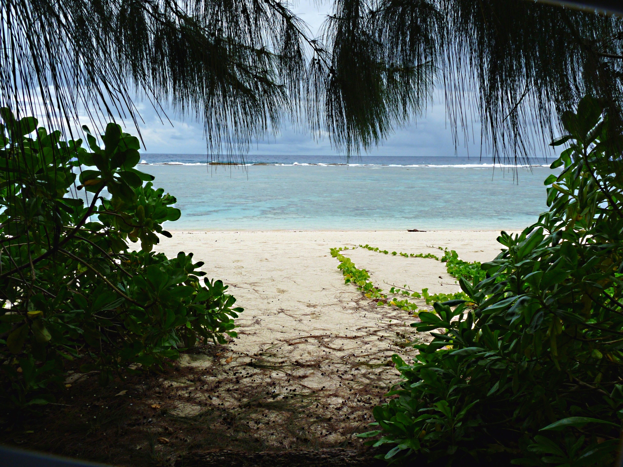
 Beach scenery in Guam
Guam (/ˈɡwɑːm/ (
 listen); Chamorro: Guåhan) is an organized, unincorporated territory of the United States located in the western Pacific Ocean. It is one of five U.S. territories with an established civilian government.[3][4] Guam is listed as one of 16 Non-Self-Governing Territories by the Special Committee on Decolonization of the United Nations.[5] The island's capital is Hagåtña (formerly Agaña). Guam is the largest and southernmost of the Mariana Islands.
The Chamorros, Guam's indigenous people, first populated the island approximately 4,000 years ago.[6] The island has a long history of European colonialism. Discovered by Ferdinand Magellan during a Spanish expedition on March 6, 1521, the first colony was established in 1668 by Spain with the arrival of settlers including Padre San Vitores, a Catholic missionary. For more than two centuries Guam was an important stopover for the Spanish Manila Galleons that crossed the Pacific annually. The island was controlled by Spain until 1898, when it was surrendered to the United States during the Spanish-American War and later formally ceded as part of the Treaty of Paris.
As the largest island in Micronesia and the only U.S.-held island in the region before World War II, Guam was captured by the Japanese on December 8, 1941, hours after the bombing of Pearl Harbor, and was occupied for two and a half years.
During the occupation, the people of Guam were subjected to acts that included torture, beheadings and rape,[7] and were forced to adopt the Japanese culture.[8] Guam was subject to fierce fighting when US troops recaptured the island on July 21, 1944, a date commemorated every year as Liberation Day.[9]
Today, Guam's economy is supported by its principal industry, tourism, which is composed primarily of visitors from Japan. Guam's second-largest source of income is the United States military.[10]
Contents
History
Main article: History of GuamIt is believed that Guam was first discovered by people from southeastern Indonesia around 2000 BC. Most of what is known about pre-contact ("Ancient") Chamorros comes from legends and myths, archaeological evidence, Jesuit missionary accounts, and observations from visiting scientists like Otto von Kotzebue and Louis de Freycinet.[citation needed]
When Europeans first arrived on Guam, Chamorro society had three classes: matua (upper class), achaot (middle class), and mana'chang (lower class). The matua were located in the coastal villages, which meant they had the best access to fishing grounds, whereas the mana'chang were located in the interior of the island. Matua and mana'chang rarely communicated with each other, and matua often used achaot as an intermediary. There were also "makåhna" (similar to shamans), skilled in healing and medicine. Belief in spirits of ancient Chamorros called "Taotao mo'na" still persists as a remnant of pre-European culture. When Magellan arrived on Guam, he was greeted by hundreds of small outrigger canoes that appeared to be flying over the water, due to their considerable speed. These outrigger canoes were called Proas, and resulted in Magellan naming Guam Islas de las Velas Latinas ("Islands of the Lateen Sails").
Guam, the only Spanish outpost in the Pacific Ocean east of the Philippines, became the regular port between Acapulco, Mexico and Manila from 1565 to 1815,[citation needed] and (since Philippine independence) the most western outpost of actual United States territory in the Pacific. It is the biggest single segment of Micronesia, the largest islands between the islands of Kyushu (Japan), New Guinea, the Philippines, and the Hawaiian Islands.
Latte stones are stone pillars that are only found in the Mariana Islands and are a recent development in Pre-Contact Chamorro society. The latte stone was used as a foundation on which thatched huts were built. Latte consist of a base shaped from limestone called the haligi and with a capstone, or tåsa, made either from a large brain coral or limestone, placed on top. Using carbon-dating, archaeologists have broken Pre-Contact Guam (i.e. Chamorro) history into three periods: "Pre-Latte" (BC 2000? to AD 1) "Transitional Pre-Latte" (AD 1 to AD 1000), and "Latte" (AD 1000 to AD 1521).
Archaeological evidence also suggests that Chamorro society was on the verge of another transition phase by 1521, as latte stones became bigger. Assuming the larger latte stones were used for chiefly houses, it can be argued that Chamorro society was becoming more stratified, either from population growth or the arrival of new people.[citation needed] The theory remains tenuous, however, due to lack of evidence, but if proven correct, will further support the idea that Pre-Contact Chamorros lived in a vibrant and dynamic environment.[citation needed]
Spanish colonization and the Manila galleons
Portuguese navigator Ferdinand Magellan, sailing for the King of Spain, reached the island in 1521 during his fleet's circumnavigation of the globe. General Miguel López de Legazpi claimed Guam for Spain in 1565. Spanish colonization commenced in 1668 with the arrival of Padre San Vitores, who established the first Catholic mission. The islands were part of the Spanish East Indies governed from the Philippines, which were in turn part of the Viceroyalty of New Spain based in Mexico City.
Between 1668 and 1815, Guam was an important resting stop for the Spanish Manila galleons, a fleet that covered the Pacific trade route between Acapulco (Mexico) and Manila (Philippines). To protect these Pacific fleets, Spain built a number of defensive structures such as Fort Nuestra Señora de la Soledad in Umatac, which are still standing today. Other reminiscences of colonial times include the old Governor's Palace in Plaza de España and the Spanish Bridge, both in Hagatña. Guam's Cathedral Dulce Nombre de Maria was also built during Spanish times in the 17th century. Guam, along with the rest of the Mariana and Caroline Islands, were treated as part of Spain's colony in the Philippines. While Guam's Chamorro culture has indigenous roots, the cultures of both Guam and the Northern Marianas have many similarities with Spanish and Mexican culture due to three centuries of Spanish rule.[10]
The Spanish-American War and World War II
 Philippine Spanish peso with commemorative stamp of the occupation of Guam by the U.S. in 1899.
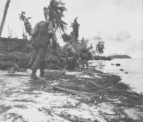
 First assault wave of Marines take cover prior to moving inland during the 1944 Battle of Guam.
The United States took control of the island in the 1898 Spanish-American War, as part of the Treaty of Paris. Guam came to serve as a station for American ships traveling to and from the Philippines, while the Northern Mariana Islands passed to Germany, and then to Japan.[10]
During World War II, Guam was attacked and invaded by the armed forces of Japan on December 8, 1941. Anticipating the attack, the Navy had all military dependents transported away from the island, but did not inform the native Chamorros of the possible bombardment.[citation needed]
The Northern Mariana Islands had become a Japanese protectorate before the war. It was the Chamorros from the Northern Marianas who were brought to Guam to serve as interpreters and in other capacities for the occupying Japanese force. The Guamanian Chamorros were treated as an occupied enemy by the Japanese military. After the war, this would cause resentment between the Guamanian Chamorros and the Chamorros of the Northern Marianas. Guam's Chamorros believed their northern brethren should have been compassionate towards them, whereas having been occupied for over 30 years, the Northern Mariana Chamorros were loyal to Japan.
Guam's Japanese occupation lasted for approximately thirty-one months. During this period, the indigenous people of Guam were subjected to forced labor, family separation, incarceration, execution, concentration camps and forced prostitution. Approximately one thousand people died during the occupation, according to Congressional Testimony in 2004. Some historians estimate that war violence killed 10% of Guam's some 20,000 population.[11]
The United States returned and fought the Battle of Guam on July 21, 1944, to recapture the island from Japanese military occupation. More than 18,000 Japanese were killed as only 485 surrendered. Sergeant Shoichi Yokoi, who surrendered in January 1972, appears to have been the last confirmed Japanese holdout in Guam.[12] To this day, Guam remains the only U.S. soil with a sizable population to have been occupied by a foreign military power, since the War of 1812. The United States also captured and occupied the Northern Marianas.
Post-war
After the war, the Guam Organic Act of 1950, established Guam as an unincorporated organized territory of the United States, provided for the structure of the island's civilian government, and granted the people U.S. citizenship. Since Guam is not a U.S. state, U.S. citizens residing on Guam are not allowed to vote for president and their congressional representative is a non-voting member.[10]
Proposed name change

The name "Guam" is an exonym. In his final State of the Island Address on February 15, 2010, Governor Felix Camacho called for Guam to formally be henceforth referred to as Guahan (Guåhan), the name of the island in the indigenous Chamorro language,[13] and issued an executive order to make it official.[14][15] Camacho simultaneously began referring to himself as the "Governor of Guahan".[16]
According to historian Toni Ramírez of the Historic Preservation Office of the Guam Department of Parks and Recreation, the name Guahan means "we have"[15] or "a place that has",[13] in reference to the island's rivers and other natural resources, which were relatively rare on other neighboring Micronesian islands.[15]
Guahan or Guaján was the name widely used on the island between 1521 and 1898.[13][17] However, both the names Guam and Guahan appear in historic documents and maps dating back hundreds of years, according to Peter Onedera, a historian and Chamorro language professor at the University of Guam.[16] Richard Leary, the first United States Naval Governor of the island, adopted the name Guam in 1900 when he called it "isle of Guam".[15][16]
Two-term Governor Camacho, who cannot seek a third term, will leave office in 2011.[16] He explained in his final State of the Island Address that the name change will solidify his legacy as governor and cement his place in history.[16] He argues that the change to Guahan will reaffirm the island's distinct identity and Chamorro cultural heritage.[15] Camacho's order specifically states that the change "enhances the practice of the Chamorro language and promotes the historic and cultural connection to the island".[16] The executive order will apply only to local Guamanian government institutions, official communications, business transactions and signs at this time.[16] However, Camacho expressed interest in having community leaders, businesses and lawmakers adopt the Guahan name as well.[16] He further announced that he would introduce Bill 331 in the Guam Legislature to change the name to Guahan in law.[13] The executive order does not have a set deadline for agencies to adopt the change, in order to lessen any time or monetary burdens on the government during a prolonged economic recession.[16] Changes should be made when it is most convenient for the government agency, such as ordering new office letterhead.[16]
Reaction to the proposed change was mixed among both lawmakers and residents. Speaker of the legislature Judith Won Pat noted that the change could help restore a perceived loss of identity in Guam.[15] She told the media, "This is the age where, throughout the world, people want to know who they are and find their identity. This is very important for Guam as well."[15] Author and former senator Katherine Aguon, who recently published a Chamorro–English dictionary, also supported the name change, but emphasized that any proposal should be approved by Guamanian voters.[16]
An official, sanctioned name change may have some economic repercussions on the island. Then senator (and later governor) Eddie Calvo, while supporting the order, noted that the costs of changing the name on signage, documents and advertising campaigns would have to be taken into account.[15] The Guam Visitors Bureau (GVB), which has spent millions of dollars to brand Guam as a major tourist and business destination using the island's current name, recently launched a new marketing campaign called "We Are Guam".[18] The economic costs of changing all road and welcome signs, as well as documents and tourism campaigns, would have to be evaluated.[18]
Geography
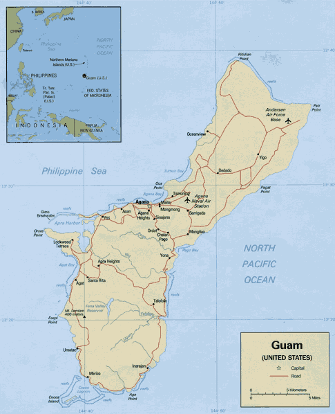
Main article: Geography of Guam Map of Guam
Guam lies between 13.2°N and 13.7°N and between 144.6°E and 145.0°E, and has an area of 212 square miles (549 km2), making it the 32nd largest island of the United States. It is the southernmost and largest island in the Mariana island chain and is also the largest island in Micronesia. This island chain was created by the colliding Pacific and Philippine Sea tectonic plates. Guam is the closest land mass to the Mariana Trench, a deep subduction zone, that lies beside the island chain to the east. Challenger Deep, the deepest surveyed point in the Oceans, is southwest of Guam at 35,797 feet (10,911 m) deep. The highest point in Guam is Mount Lamlam, which is 1,332 feet (406 m).
The island of Guam is 30 miles (48 km) long and 4 miles (6 km) to 12 miles (19 km) wide. The island experiences occasional earthquakes due to its location on the western edge of the Pacific Plate and near the Philippine Sea Plate. In recent years, earthquakes with epicenters near Guam have had magnitudes ranging from 5.0 to 8.7. Unlike the Anatahan volcano in the Northern Mariana Islands, Guam is not volcanically active.[19] However, due to its proximity to Anatahan, vog does occasionally affect Guam.[20]
A coral table reef with deepwater channels surrounds most of Guam. Sandy beaches, rock cliff lines and mangroves characterize the coastline area. Sheer limestone coastal cliffs dominate the north, while the southern end of the island is mountainous, with lower hills in between.[21]
Climate
The climate is characterized as tropical marine. The weather is generally hot and very humid with little seasonal temperature variation. The mean high temperature is 86 °F (30 °C) and mean low is 76 °F (24 °C) with an average annual rainfall of 96 inches (2,180 mm). The dry season runs from December through June. The remaining months (July through November) constitute the rainy season. The months of January and February are considered the coolest months of the year with night time temperatures in the mid to low 70s and generally lower humidity levels. The highest risk of typhoons is during October and November. They can, however, occur year-round.
Guam is located in what has been nicknamed "Typhoon Alley" and it is common for the island to be threatened by tropical storms and possible typhoons during the wet season. The most intense typhoon to pass over Guam recently was Super Typhoon Pongsona, with sustained winds of 144 miles per hour, gusts to 173 miles per hour, which slammed Guam on December 8, 2002, leaving massive destruction.
Since Super Typhoon Pamela in 1976, wooden structures have been largely replaced by concrete structures.[22][23] During the 1980s wooden utility poles began to be replaced by typhoon-resistant concrete and steel poles. After the local Government enforced stricter construction codes, many home and business owners built their structures out of reinforced concrete with installed typhoon shutters.
Demographics
Main article: Demographics of GuamSee also: List of U.S. states and territories by populationHistorical populations Census Pop. %± 1910 11,806 — 1920 13,275 12.4% 1930 18,509 39.4% 1940 22,290 20.4% 1950 59,498 166.9% 1960 67,044 12.7% 1970 84,996 26.8% 1980 105,979 24.7% 1990 133,152 25.6% 2000 154,805 16.3% 2010 159,436 3.0% According to the U.S. census conducted in 2000, the population of Guam was 154,805.[24] The 2008 population estimate for Guam is 175,000.[21] As of 2005, the annual population growth is 1.76%.[25] The largest ethnic group are the native Chamorros, accounting for 37.1% of the total population. Other significant ethnic groups include those of Filipino (25.5%), White (10%) indicates of both European often of Spanish and European American ancestry, and the rest are of Chinese, Japanese and Korean ancestry. Roman Catholicism is the predominant religion, with 85% of the population claiming an affiliation with it.
The programmed U.S. military buildup (2010–14) will cause an unprecedented population increase (approximately 40% or nearly 80,000 people at the peak of constructions[26]) which will significantly impact Guam's very limited and aging infrastructure. This expected population increase would otherwise occur over a 20 year period. The official languages of the island are English and Chamorro.
Culture
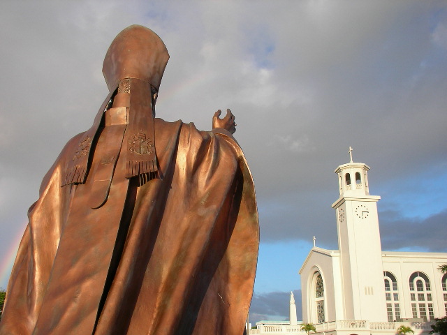
See also: Music of Guam Dulce Nombre de Maria Cathedral Basilica in Hagåtña, faced by a statue of Pope John Paul II. Roman Catholicism is the main religion in Guam.
Traditional Chamorro culture is a combination of indigenous pre-Hispanic customs and Spanish or Mexican traditions. It is manifested in Chamorro language, music, dance, sea navigation, unique cuisine, fishing, games (such as batu, chonka, estuleks, and bayogu), songs and fashion. During Spanish colonial rule (1668–1898) the majority of the population was converted to Roman Catholicism and religious festivities such as Easter and Christmas became widespread. Traditional Chamorro cuisine is largely based on corn, and includes tortillas, tamales, atole and chilaquiles, which are a clear influence from Mexico. The Chamorro language is a Malayo-Polynesian language with much Spanish influence. Many Chamorros also have Spanish surnames because of their conversion to Roman Catholic Christianity and the adoption of names from the Catálogo alfabético de apellidos, a phenomenon common to the Philippines.
Due to foreign cultural influence from Spain and the United States, important aspects of the early indigenous culture have been lost over the years, though there has been a resurgence in preserving this pre-Hispanic culture in the last few decades. Some scholars have traveled throughout the Pacific Islands conducting research to study what the original Chamorro cultural practices such as dance, language, and canoe building may have been like.
Two aspects of indigenous pre-Hispanic culture that withstood time are chenchule' and inafa'maolek. Chenchule' is the intricate system of reciprocity at the heart of Chamorro society. It is rooted in the core value of inafa'maolek. Historian Lawrence Cunningham in 1992 wrote, "In a Chamorro sense, the land and its produce belong to everyone. Inafa'maolek, or interdependence, is the key, or central value, in Chamorro culture ... Inafa'maolek depends on a spirit of cooperation and sharing. This is the armature, or core, that everything in Chamorro culture revolves around. It is a powerful concern for mutuality rather than individualism and private property rights."
 Chief Gadao is featured in many legends about Guam before European colonization.
The core culture or Pengngan Chamorro is based on complex social protocol centered upon respect: From sniffing over the hands of the elders (called mangnginge in Chamorro), the passing down of legends, chants, and courtship rituals, to a person asking for permission from spiritual ancestors before entering a jungle or ancient battle grounds. Other practices predating Spanish conquest include galaide' canoe-making, making of the belembaotuyan (a string musical instrument made from a gourd), fashioning of åcho' atupat slings and slingstones, tool manufacture, Måtan Guma' burial rituals, and preparation of herbal medicines by Suruhanu.
Master craftsmen and women specialize in weavings, including plaited work (niyok- and åkgak-leaf baskets, mats, bags, hats, and food containments), loom-woven material (kalachucha-hibiscus and banana fiber skirts, belts and burial shrouds), and body ornamentation (bead and shell necklaces, bracelets, earrings, belts and combs made from tortoise shells) and Spondylus.
The cosmopolitan nature of modern Guam poses challenges for Chamorros struggling to preserve their culture and identity amidst forces of acculturation. The increasing numbers of Chamorros, especially Chamorro youth, relocating to the U.S. Mainland has further complicated both definition and preservation of Chamorro identity.[citation needed] While only a few masters exist to continue traditional art forms, the resurgence of interest among the Chamorros to preserve the language and culture has resulted in a growing number of young Chamorros who seek to continue the ancient ways of the Chamorro people.
Government and politics
Main article: Politics of GuamSee also: List of Guam Governors and Political party strength in GuamGuam is governed by a popularly elected governor and a unicameral 15-member legislature, whose members are known as senators. Guam elects one non-voting delegate, currently Democrat Madeleine Z. Bordallo, to the United States House of Representatives. U.S. citizens in Guam vote in a straw poll for their choice in the U.S. Presidential general election, but since Guam has no votes in the Electoral College, the poll has no real effect. However, in sending delegates to the Republican and Democratic national conventions, Guam does have influence in the national presidential race, though these convention delegates are elected by local party conventions rather than voters in primaries.[10]
In the 1980s and early 1990s, there was a significant movement in favor of the territory becoming a commonwealth, which would give it a level of self-government similar to Puerto Rico and the Northern Mariana Islands. However, the federal government rejected the version of a commonwealth that the government of Guam proposed, due to it having clauses incompatible with the Territorial Clause (Art. IV, Sec. 3, cl. 2) of the U.S. Constitution. Other movements are also in existence that advocate becoming a U.S. state, union with the state of Hawaii, union with the Northern Mariana Islands as a single territory, or independence.
Villages and military bases
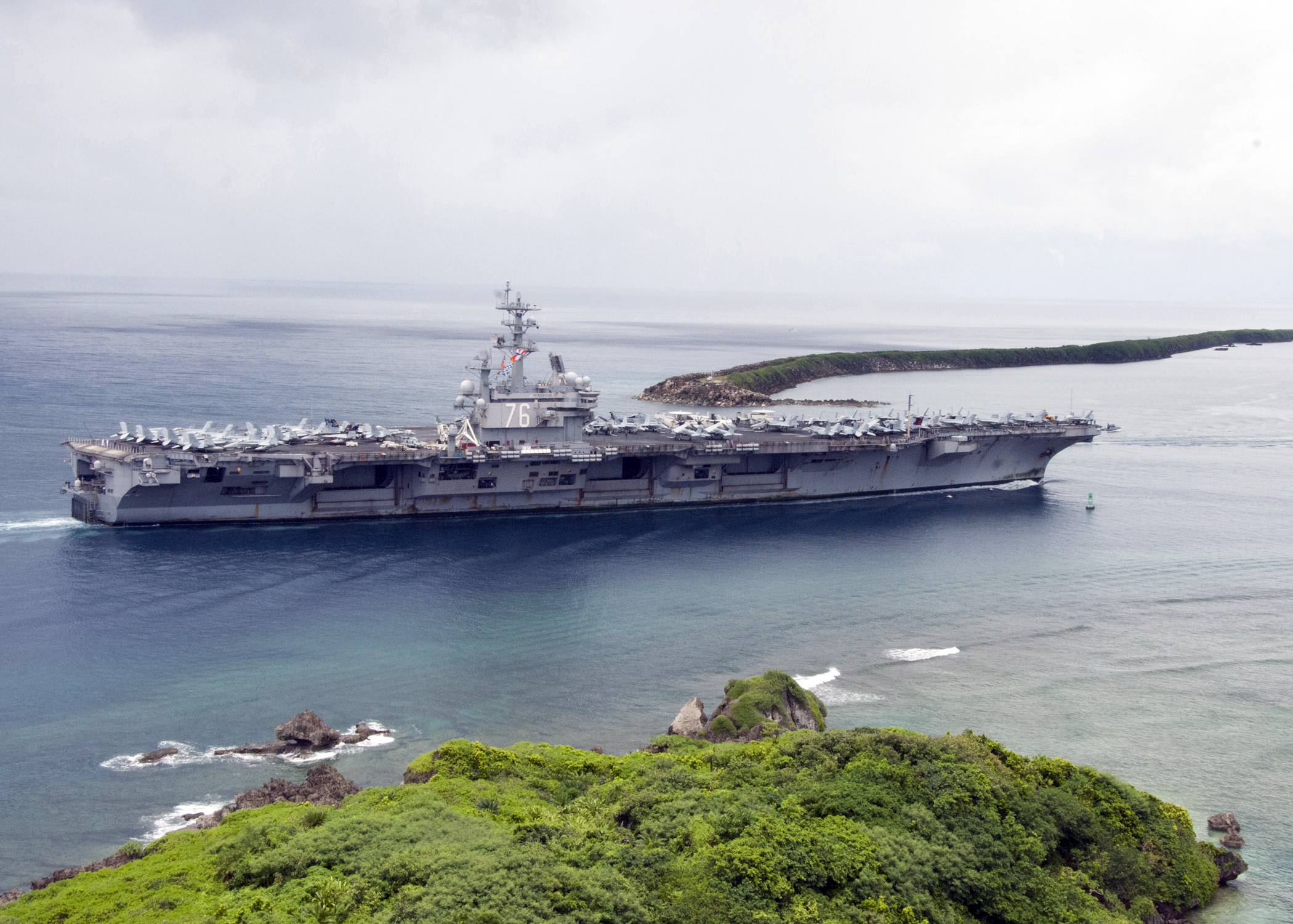
 The aircraft carrier USS Ronald Reagan (CVN 76) enters Apra Harbor for a scheduled port visit.Main article: List of villages in Guam
- See footnote[27]
Guam is divided into 19 municipalities commonly called villages: Agana Heights, Agat, Asan‑Maina, Barrigada, Chalan‑Pago‑Ordot, Dededo, Hagåtña, Inarajan, Mangilao, Merizo, Mongmong‑Toto‑Maite, Piti, Santa Rita, Sinajana, Talofofo, Tamuning, Umatac, Yigo, Yona.
The U.S. military maintains jurisdiction over its bases, which cover approximately 39,000 acres (16,000 ha), or 29% of the island's total land area:
- U.S. Naval Base Guam, U.S. Navy – Sumay
- U.S. Coast Guard Sector Guam, – Sumay
- Andersen Air Force Base, U.S. Air Force – Yigo
- Apra Harbor – Orote peninsula
- Ordnance Annex, U.S. Navy – South Central Highlands (formerly known as Naval Magazine)
- Naval Computer and Telecommunications Station, U.S. Navy – Barrigada and Finegayan
- Joint Force Headquarters-Guam, Guam National Guard – Radio Barrigada and Fort Juan Muna
In addition to on-shore military installations, Guam, along with the rest of the Mariana Islands, is being prepared to be the westernmost military training range for the U.S. Guam is currently viewed as a key military hub that will further allow U.S. military power to be projected via sea and sky.
The U.S. military has proposed to build a new aircraft carrier berth on Guam and to move 8,600 Marines, and 9,000 of their dependents, to Guam from Okinawa, Japan. Including the required construction workers, this buildup would increase Guam's population by 45%. In a February 2010 letter, the United States Environmental Protection Agency sharply criticized these plans because of a water shortfall, sewage problems and the impact on coral reefs.[28]
With the proposed increased military presence stemming from the upcoming preparation efforts and relocation efforts of U.S. Marines from Okinawa, Japan to Guam slated to begin in 2010 and last for the next several years thereafter, the amounts of total land that the military will control or tenant may grow to or surpass 40% of the entire landmass of Guam.
In January, 2011, the Ike Skelton National Defense Authorization Act for FY2011 indicated that recent significant events will delay the deadline for realigning U.S. Marine Corps service members and their families from Okinawa to Guam. The transfer may be as late as 2020. In addition, the Defense Authorization Act cut approximately $320 million from the 2011 budget request.
Villagers and the military community are inter-connected in many ways. Many villagers serve in the military or are retired. Many active duty personnel and Defense Department civilians also live in the villages outside of the military installation areas. The military and village communities have "adoption" programs where Guam's population and military personnel stationed in Guam perform community service projects.
Economy
 2009 Guam Quarter
Guam's economy depends primarily on tourism, Department of Defense installations, and locally owned businesses. Although Guam receives no foreign aid, it does receive large transfer payments from the general revenues of the U.S. federal treasury into which Guam pays no income or excise taxes; under the provisions of a special law of Congress, the Guam treasury, rather than the U.S. treasury, receives federal income taxes paid by local taxpayers to include military and civilian federal employees assigned to Guam.
Guam is a popular destination for Japanese tourists. Its tourist hub, Tumon, features over 20 large hotels, a Duty Free Shoppers Galleria, Pleasure Island district, indoor aquarium, Sandcastle Las Vegas–styled shows and other shopping and entertainment venues. It is a relatively short flight from Asia or Australia compared to Hawaii, with hotels and seven public golf courses accommodating over a million tourists per year. Although 75 percent of the tourists are Japanese, Guam receives a sizable number of tourists from South Korea, the U.S., the Philippines, and Taiwan.[29] Significant sources of revenue include duty-free designer shopping outlets, and the American-style malls: Micronesia Mall, Guam Premier Outlets, the Agana Shopping Center, and the world's largest Kmart.[30]
 The old terminal at Antonio B. Won Pat International Airport, the headquarters of Continental Micronesia, Guam's largest private-sector employer
The economy had been stable since 2000 due to increased tourism, but took a recent downturn along with most of Asia. It is expected to stabilize well ahead of the projected transfer of U.S. Marine Corps' 3rd Marine Expeditionary Force, currently in Okinawa (approximately 8,000 Marines, along with their 10,000 dependents), to Guam between 2010 and 2015. In 2003, Guam had a 14% unemployment rate, and the government suffered a $314 million shortfall.[31]
The Compacts of Free Association between the United States, the Federated States of Micronesia, the Republic of the Marshall Islands and the Republic of Palau accorded the former entities of the Trust Territory of the Pacific Islands a political status of "free association" with the United States. The Compacts give citizens of these island nations generally no restrictions to reside in the United States (also its territories), and many were attracted to Guam due to its proximity, environmental, and cultural familiarity. Over the years, it was claimed by some in Guam that the territory has had to bear the brunt of this agreement in the form of public assistance programs and public education for those from the regions involved, and the federal government should compensate the states and territories affected by this type of migration.[citation needed] Over the years, Congress had appropriated "Compact Impact" aids to Guam, the Northern Mariana Islands and Hawaii, and eventually this appropriation was written into each renewed Compact. Some, however, continue to claim the compensation is not enough or that the distribution of actual compensation received is significantly disproportionate.[citation needed]
Guam's largest single private sector employer, with about 1,400 jobs, is Continental Micronesia, a subsidiary of Continental Airlines.[32] As of 2008 the airline's annual payroll in Guam was $90 million.[33]
Transportation and communications
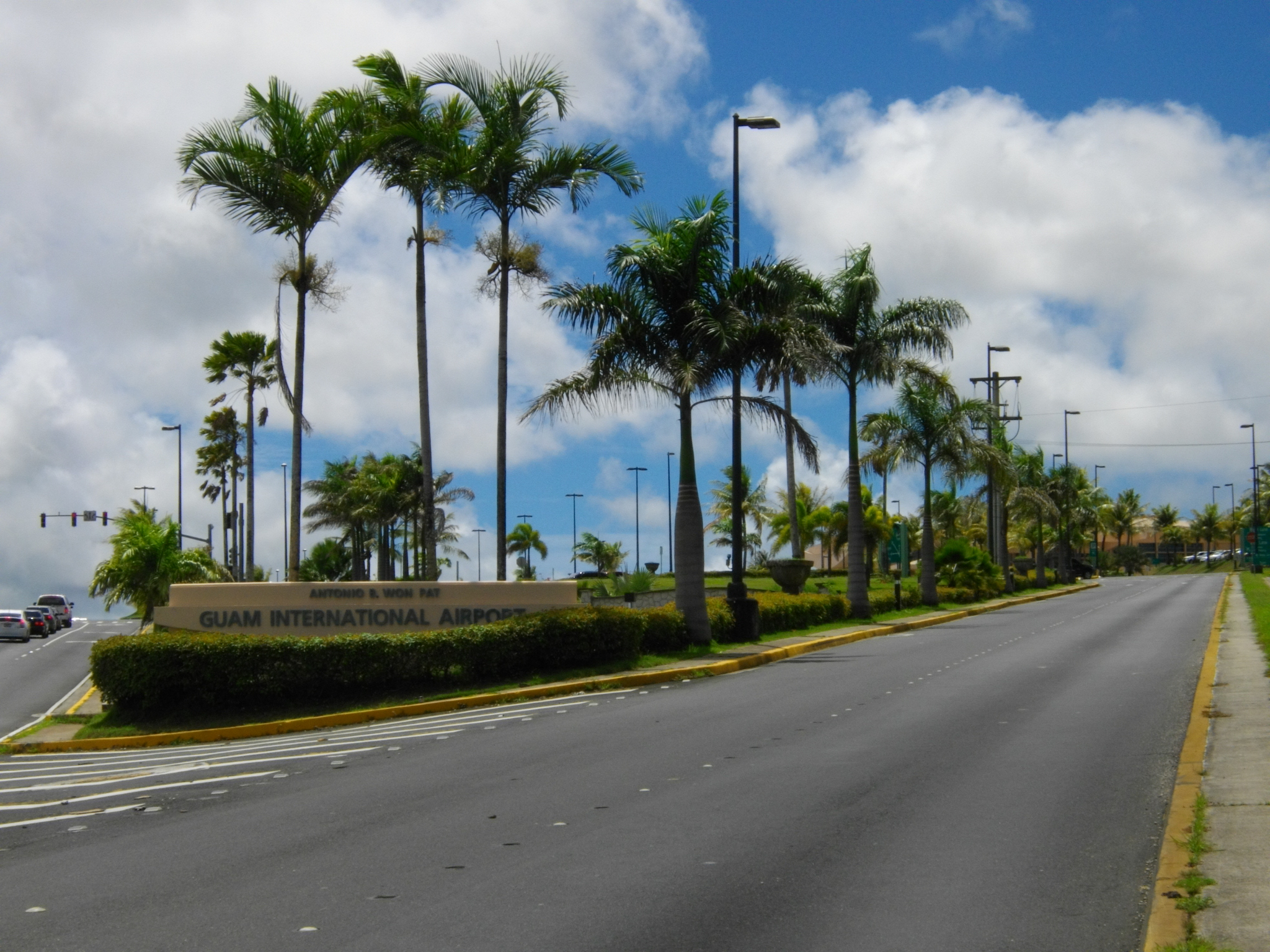
Main articles: Communications in Guam and Transportation in Guam The entrance to the Antonio B. Won Pat International Airport
Most of the island has state-of-the-art mobile phone services and high-speed internet widely available through either cable or DSL. Guam was added to the North American Numbering Plan (NANP) in 1997 (country code 671 became NANP area code 671),[34] removing the barrier of high cost international long-distance calls to the U.S. Mainland.
 Flown cover carried both directions on the first commercial flights between Guam and the United States. October 5–24, 1935.
In 1899, the local postage stamps were overprinted "Guam" as was done for the other former Spanish colonies, but this was discontinued shortly thereafter and regular U.S. postage stamps have been used ever since. Because Guam is also part of the U.S. Postal System ("state" code: GU, ZIP code range: 96910–96932), mail to Guam from the U.S. mainland is considered domestic and no additional charges are required. Private shipping companies, such as FedEx, UPS, and DHL, however, have no obligation to and do not regard Guam as domestic.
The speed of mail traveling between Guam and the states varies depending on size and time of year. Light, first-class items generally take less than a week to or from the mainland, but larger first-class or Priority items can take a week or two. Fourth-class mail, such as magazines, are transported by sea after reaching Hawaii. Most residents use post office boxes or private mail boxes, although residential delivery is becoming increasingly available. Incoming mail not from the Americas should be addressed to "Guam" instead of "USA" to avoid being routed the long way through the U.S. mainland and possibly charged a higher rate (especially from Asia).
The Commercial Port of Guam is the island's lifeline because most products must be shipped into Guam for consumers. The port is also the regional transhipment hub for over 500,000 customers throughout the Micronesian region. The port is the shipping and receiving point for containers designated for the island's US Department of Defense installations, Andersen Air Force Base and Commander, Naval Forces Marianas and eventually the Third Marine Expeditionary Force.
Guam is served by the Antonio B. Won Pat International Airport, which is a hub for Continental Airlines. The island is outside the United States customs zone so Guam is responsible for establishing and operating its own customs and quarantine agency and jurisdiction. Therefore, the U.S. Customs and Border Protection only carries immigration (but not customs) functions. Since Guam is under federal immigration jurisdiction, passengers arriving directly from the States skip immigration and proceed directly to Guam Customs and Quarantine.
However, due to the Guam and CNMI visa waiver program for certain countries, an eligibility pre-clearance check is carried on Guam for flights to the States. For travel from the Northern Mariana Islands to Guam, a pre-flight passport and visa check is performed before boarding the flight to Guam. On flights from Guam to the Northern Mariana Islands, no immigration check is performed. Traveling between Guam and the States through a foreign point (for example, a Japanese airport), however, does require a passport.
Most residents travel within Guam using personally owned vehicles. The local government currently outsources the only public bus system (Guam Mass Transit Authority), and some commercial companies operate buses between tourist-frequented locations.
Ecological issues
Guam exemplifies the effects of bioinvasion.
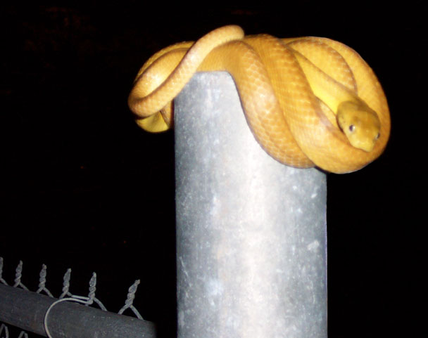
Brown tree snake
Believed to be a stowaway on a U.S. military transport near the end of World War II, the brown tree snake (Boiga irregularis) came to Guam and nearly eliminated the native bird population of an island that previously had no native species of snake; this snake has no natural predators on the island. While slightly venomous, the brown tree snake is relatively harmless to human beings. Although some studies have suggested a high density of brown tree snakes on Guam, residents rarely see these nocturnal snakes. The United States Department of Agriculture has trained detector dogs to keep brown tree snakes out of the island's cargo flow, and the United States Geological Survey has dogs capable of detecting snakes in forested environments around the region's islands.[35][36]
The consequence of the introduction of the brown tree snake has been significant over the past several decades. The reduction of local bird populations has been attributed to the introduction and presence of brown tree snakes, who eat them. According to many elders, koko birds were common in Guam prior to World War II; they are no longer around largely due to predation by brown tree snakes.[37]
Coconut Rhinoceros Beetle
An infestation of the coconut rhinoceros beetle (CRB), Oryctes rhinoceros, was detected on Guam on September 12, 2007. CRB is not known to occur in the United States except in American Samoa. Delimiting surveys performed September 13–25, 2007 indicated that the infestation was limited to Tumon Bay and Faifai Beach, an area of approximately 900 acres (3.6 km2). Guam Department of Agriculture (GDA) placed quarantine on all properties within the Tumon area on October 5 and later expanded the quarantine to about 2,500 acres (10 km2) on October 25; approximately 0.5 miles (800 m) radius in all directions from all known locations of CRB infestation. CRB is native to Southern Asia and distributed throughout Asia and the Western Pacific including Sri Lanka, Upolu, Western Samoa, American Samoa, Palau Islands, New Britain, West Irian, New Ireland, Pak Island and Manus Island (New Guinea), Fiji, Cocos (Keeling) Islands, Mauritius, and Reunion.
Adults are the injurious stage of the insect. They are generally night-time fliers and when they alight on a host, they chew down into the folded, emerging fronds of coconut palms to feed on sap. V-shaped cuts in the fronds and holes through the midrib are visible when the leaves grow out and unfold. If the growing tip is injured, the palm may be killed or severe loss of leaf tissue may cause decreased nut set. Feeding wounds may also serve as an infection pathway for pathogens or other pests. The effects of adult boring may be more severe on younger palms where spears are narrower. Mortality of young palms has already been observed on Guam. Oviposition and larval development typically occurs in decaying coconut logs or stumps.
Control measures have been developed for CRB and the current strategy on Guam is to implement an integrated eradication program using pheromone-baited, attractive traps to capture adults, various methods to eliminate infested and susceptible host material, and pesticides to kill larvae and adults. Pesticides may also be applied to uninfested trees as a preventive treatment. USDA-APHIS has completed an Environmental Assessment for the coconut rhinoceros beetle eradication program on Guam (EA Number: GU-08-1, http://www.guaminsects.net/uogces/kbwiki/images/d/dc/CRB_EA.pdf). The eradication program is a cooperative effort between USDA (APHIS and Forest Service), GDA and the University of Guam (UOG). This document follows the Forest Service Pest Risk Assessment (Kliejunas et al. 2001) format and is intended to provide information regarding the current status of CRB on Guam, its potential to spread to uninfested locales, and the consequences of establishment. The high, moderate or low riskvalues are based on available biological information and the subjective judgment of the authors. In 2010, GDA and UOG set out to introduce a virus in the adult population designed to kill the beetle through infection by beetles released from the labs.
In June 2010, during a controlled release of infected adult beetles and in a joint venture with a team from New Zealand, they discovered "...unusual rhino beetle behavior: the beetles were not breeding on the ground in decayed logs as normal; they were breeding in the detritus trapped in the tree branches. In cutting down 11 large coconut palms they found a complete ecosystem in the crowns including brown tree snakes, crabs, and, unfortunately, all life stages of rhinoceros beetles, from eggs to larva to young adults. This new discovery makes the release of the bio-control virus even more vital. Moore thinks this arboreal breeding behavior, seen only on Guam, may be because the brown tree snake has wiped out most of Guam's rats. Elsewhere, rats love to live in coconut crowns, and they love to eat rhino beetle grubs. This never-before-seen rhino beetle behavior of breeding in the crowns of coconut trees underscores an important point of invasive species on small islands. Their impact is often severe because there are no natural enemies, such as predators, parasites, or diseases, to control their population growth."[38]
A joint initiative between Guam Customs & Quarantine (which trains CRB detector dogs and CRB handlers), Guam Department of Agriculture (which employs CRB detector dog handlers), University of Guam College of Agriculture (which provides CRB Detector Dog program funding) and the U.S. Department of Agriculture Animal and Plant Health Inspection Station (the federal agency providing strategic direction and regulatory guidance) to form the nation's first Bio-Security Task Force which features the nation's first CRB trained detector dogs. This program will provide enhanced capability and capacity for the invasive species interdiction and eradication program in order to mitigate these species on Guam and prevent it from spreading to other jurisdictions in the United States. This Task Force increases the island's capacity to handle the increased volume of invasive species associated with the unprecented military buildup on Guam.
Other invasive animal species
From the seventeenth through nineteenth centuries, the Spanish introduced pigs, dogs, chickens, the Philippine deer (Cervus mariannus), black francolins, and water buffalo. Water buffalo, known as carabao locally, have cultural significance. Herds of these animals obstruct military base operations and harm native ecosystems. After birth control and adoption efforts were ineffective, the U.S. military began culling the herds in 2002 leading to organized protests from island residents.[39]
Other introduced species include cane toads imported in 1937, the giant African snail (an agricultural pest introduced during WWII by Japanese occupation troops) and more recently frog species which could threaten crops in addition to providing additional food for the brown tree snake population. Reports of loud chirping frogs native to Puerto Rico and known as coquí, that may have arrived from Hawaii, have led to fears that the noise could threaten Guam's tourism.[40]
Introduced feral pigs and deer, over-hunting, and habitat loss from human development are also major factors in the decline and loss of Guam's native plants and animals.
Threats to indigenous plants
Invading animal species are not the only threat to Guam's native flora. Tinangaja, a virus affecting coconut palms, was first observed on the island in 1917 when copra production was still a major part of Guam's economy. Though coconut plantations no longer exist on the island, the dead and infected trees that have resulted from the epidemic are seen throughout the forests of Guam.[41] Also during the past century, the dense forests of northern Guam have been largely replaced by thick tangan tangan brush (Leucaena-native to the Americas). Much of Guam's foliage was lost during World War II. In 1947, the U.S. military is thought to have planted tangan tangan by seeding the island from the air to prevent erosion. Tangan tangan was present on the island before 1905 (Stone,Useful Plants of Guam, 1905). In southern Guam, non-native grass species also dominate much of the landscape.
Wildfires
 Guam's grassland
Wildfires plague the forested ("boonie" or "jungle") areas of Guam every dry season despite the island's humid climate. Most fires are man-caused with 80 percent resulting from arson.[42] Poachers often start fires to attract deer to the new growth. Invasive grass species that rely on fire as part of their natural life cycle grow in many regularly burned areas. Grasslands and "barrens" have replaced previously forested areas leading to greater soil erosion. During the rainy season sediment is carried by the heavy rains into the Fena Lake Reservoir and Ugum River, leading to water quality problems for southern Guam. Eroded silt also destroys the marine life in reefs around the island. Soil stabilization efforts by volunteers and forestry workers to plant trees have had little success in preserving natural habitats.[43]
Aquatic preserves
 Ritidian Beach, in the Guam National Wildlife Refuge
As a vacation spot for scuba divers, efforts have been made to protect Guam's coral reef habitats from pollution, eroded silt, and overfishing that have led to decreased fish populations. In recent years the Department of Agriculture, Division of Aquatic and Wildlife Resources has established several new marine preserves where fish populations are monitored by biologists.[44] Prior to adopting U.S. Environmental Protection Agency standards, portions of Tumon Bay were dredged by the hotel chains in order to provide a better experience for hotel guests.[45][46] Tumon Bay has since been made into a preserve. A federal Guam National Wildlife Refuge in northern Guam protects the decimated sea turtle population in addition to a small colony of Mariana fruit bats.[47] Harvest of sea turtle eggs was a common occurrence on Guam prior to World War II. The Green sea turtle (Chelonia mydas) was harvested legally on Guam prior to August 1978, when it was listed as threatened under the Endangered Species Act. The Hawksbill sea turtle (Eretmochelys imbricata) has been on the endangered list since 1970. In an effort to ensure protection of sea turtles on Guam, routine sightings are counted during aerial surveys and nest sites are recorded and monitored for hatchlings.
Traditional harvests of sea turtles were primarily for local consumption at fiestas, weddings, funerals, and christenings. In recent times, poaching of sea turtles has been known to occur on Guam due to the traditional demand for its meat. Capture of the responsible parties has been difficult, although arrests have been made for unauthorized take. Effective conservation and enforcement will be critical to the recovery efforts of this project.
DAWR will continue to give sea turtle presentations for community awareness, especially through the elementary-secondary school system and University of Guam. In addition, the recommendation to produce and distribute sea turtle posters and pamphlets would help to enhance conservation and recovery awareness within the local community.
Guam's Division of Aquatic and Wildlife Resources (DAWR) Sea Turtle Recovery Program (STRP) is funded in part by the NMFS Honolulu, PIAO to determine the extent of Guam's resident/nesting sea turtle populations and nesting habitats by conducting beach surveys and satellite tracking. ComNavMarianas has funded part of the satellite telemetry portion of the project through the purchase of satellite tags and satellite time. The objectives of the project are:
- To collect baseline population size-structure (age and size) and genetic information for sea turtles in and about Guam.
- To survey Guam's beaches for sea turtle nesting activity for both green turtle (Chelonia mydas) and hawksbill (Eretmochelys imbricata) throughout the nesting period in order to determine the size of the nesting population of sea turtles on Guam and to employ a variety of tagging techniques to determine movement, residency and further define population dynamics.
- To establish a Guam-based sea turtle-working group consisting of natural resource stakeholders and involve them in the refinement of the implementation plan.
The acquisition of satellite tagging materials and training was completed in March and April 2000. On June 28, 2000, an approximately 250–300 pound Green sea turtle (Chelonia mydas) was Argos satellite-tagged and tracked after making a false crawl (i.e., one in which no nest was made) on Explosive Ordnance Disposal Beach, Andersen Air Force Base. A poaching arrest was also made on the following morning concerning a 22 lb. C. mydas that was illegally speared in the Tumon Bay Marine Preserve Area.
-

Whitespotted boxfish (Ostracion meleagris)
-

Royal angelfish (Pygoplites diacanthus)
Reef fish of Guam Education
Colleges and universities
 University of Guam Jesus and Eugenia Leon Guerrero Building
The University of Guam (UOG), Guam's land-grant university, and Guam Community College, both fully accredited by the Western Association of Schools and Colleges, offer courses in higher education.[48] UOG is a member of the exclusive group of only 76 U.S. land-grant institutions in the entire United States. Pacific Islands University is a small Christian liberal arts institution nationally accredited by the Transnational Association of Christian Colleges and Schools. They offer courses at both the undergraduate and graduate levels.
Primary and secondary schools
See also: List of schools in GuamThe Guam Public School System[49] serves the entire island of Guam. In 2000, 32,000 students attended Guam's public schools. Guam Public Schools have struggled with problems such as high dropout rates and poor test scores.[50][51] Guam's educational system has always faced unique challenges as a small community located 6,000 miles (9,700 km) from the U.S. mainland with a very diverse student body including many students who come from backgrounds without traditional American education.[52] An economic downturn in Guam since the mid-1990s has compounded the problems in schools.[53]
Prior to September 1997, the U.S. Department of Defense partnered with Guam Board of Education.[54] In September 1997 the DoDEA opened its own schools for children of military personnel.[55] DoDEA schools, which also serve children of some federal civilian employees, had an attendance of 2,500 in 2000. DoDEA Guam operates three elementary/middle schools and one high school.[56]
Public libraries
Guam Public Library System operates the Nieves M. Flores Memorial Library in Hagåtña and five branch libraries.[57]
Health care
The Government of Guam maintains the island's main health care facility, Guam Memorial Hospital in Tamuning.[58] U.S. board certified doctors and dentists practice in all specialties. In addition, the U.S. Naval Hospital in Agana Heights[59] serves active-duty members and dependents of the military community.
Motion pictures
Several films have been shot on Guam including Arachnid (1998) and the government-funded Max Havoc: Curse of the Dragon (2004), which has been mired in lawsuits and accusations of fraud perpetrated against the government and people of Guam by Hollywood filmmakers John Laing and Albert Pyun.[60] Although set on Guam, No Man Is an Island (1962), was not shot on the island, but rather in the Republic of the Philippines.
Sports
Pacific Games
Guam has hosted the Pacific Games twice, for the first time in 1975 and most recently in 1999. Guam finished 7th of 22 countries at the 2007 Pacific Games and are due to compete in the 2011 Pacific Games from August 27 to September 10.
Football
The Guam national football team was founded in 1975 and joined FIFA in 1996. Guam are one of FIFA's weakest teams and only managed their first victory over a FIFA-registered side in 2009, when they defeated Mongolia in the East Asian Cup. The national team play at the Guam National Football Stadium, which has a capacity of 1,000. The top division in Guam is the Guam Men's Soccer League. The current champions are Cars Plus FC and Guam Shipyard are the country's most successful club, with six championships.
Rugby Union
The country are represented in rugby union by the Guam national rugby union team. The team have never qualified for a Rugby World Cup. Guam played their first match in 2005, an 8-8 draw with India. Guam's biggest win was a 74-0 thrashing of Brunei in June 2008.
See also
- Outline of Guam
- Index of Guam-related articles
- List of National Register of Historic Places in Guam
- List of people from Guam
- Mariana Islands
- Mariana Trench
- Micronesia
- Pacific Ocean
- Territories of the United States
References
- ^ CIA Factbook: Guam
- ^ "World Population Prospects – Table A.1". UN Department of Economic and Social Affairs. http://www.un.org/esa/population/publications/wpp2008/. Retrieved 2009-07-21.
- ^ "U.S. Territories." DOI Office of Insular Affairs. February 9, 2007.
- ^ "DEFINITIONS OF INSULAR AREA POLITICAL ORGANIZATIONS." Office of Insular Affairs. Retrieved October 31, 2008.
- ^ History of U.N. Decolonisation Committee - Official U.N. Website
- ^ Kanton Tasi - Guam's Draft Commonwealth Act
- ^ War Restitution Act : hearing before the Subcommittee on Insular and International Affairs of the Co... | National Library of Australia
- ^ Higuchi, Wakako (June 2001). "The Japanisation Policy for the Chamorros of Guam, 1941-1944". The Journal of Pacific History 36 (1): 19-35.
- ^ "Guam police arrest suspect in memorial theft". Marine Corps Times. Associated Press. July 7, 2007. http://www.marinecorpstimes.com/news/2007/07/ap_guammemorialtheft_070707/. Retrieved April 5, 2010.
- ^ a b c d e Rogers, Robert F. (1995). Destiny's Landfall: A History of Guam. Honolulu: University of Hawaii Press. ISBN 978-0824816780.
- ^ Werner Gruhl, Imperial Japan's World War Two, 1931–1945, Transaction Publishers, 2007 ISBN 978-0-7658-0352-8
- ^ Kristof, Nicholas D. "Shoichi Yokoi, 82, Is Dead; Japan Soldier Hid 27 Years," New York Times. September 26, 1997.
- ^ a b c d "Camacho wants Guam renamed "Guahan"". KUAM. 2010-02-16. http://www.kuam.com/Global/story.asp?S=11996329. Retrieved 2010-02-18.
- ^ "Governor Issues Executive Order Changing Island Name To Guahan". Pacific News Center. 2010-02-16. http://www.pacificnewscenter.com/index.php?option=com_content&view=article&id=3315:governor-issues-executive-order-changing-island-name-to-guahan&catid=50:homepage-slideshow-rokstories. Retrieved 2010-02-18.[dead link]
- ^ a b c d e f g h Tamondong, Dionesis (2010-02-16). "Camacho: Name change will affirm identity". Pacific Daily News. http://www.guampdn.com/article/20100216/NEWS01/2160308/1002/Camacho-Name-change-will-affirm-identity. Retrieved 2010-02-18.[dead link]
- ^ a b c d e f g h i j k Limtiaco, Steve (2010-02-18). "Residents mixed on name change". Pacific Daily News. http://www.guampdn.com/article/20100218/NEWS01/2180306/1002/NEWS01/Residents-mixed-on-name-change. Retrieved 2010-02-18.[dead link]
- ^ José Antonio Saco. Colección de papeles científicos, históricos, políticos y de otros ramos sobre la isla de Cuba. 1859.
- ^ a b "GVB Reacts To Proposed Guam Name Change". Pacific News Center. 2010-02-16. http://www.pacificnewscenter.com/index.php?option=com_content&view=article&id=3341:gvb-reacts-to-proposed-guam-name-change&catid=50:homepage-slideshow-rokstories. Retrieved 2010-02-18.[dead link]
- ^ "Geography of Guam," Official site of Guam, November 8, 2007Retrieved November 8, 2007.
- ^ "Home page of the Anahatan volcano," USGS-CNMI, November 8, 2007Retrieved November 8, 2007.
- ^ a b "Guam," CIA World Factbook, April 17, 2007. Retrieved April 19, 2007.
- ^ "Guam Catastrophe Model". Risk Management Solutions. http://www.rms.com/Catastrophe/Models/Guam.asp. Retrieved 2007-06-16.
- ^ "Winds". PacificWorlds.com. http://www.pacificworlds.com/guam/land/winds.cfm. Retrieved 2007-06-16.
- ^ . "Guam Summary File," American FactFinder, Census 2000 Guam. Retrieved April 19, 2007.
- ^ "MIPT Terrorism Knowledge Base: Guam". 2007-05-17. http://www.tkb.org/Country.jsp?countryCd=GQ. Retrieved 2007-07-19.[dead link]
- ^ EIS: 79,178 new people on island by 2014, Pacific Daily News, 2009-11-21
- ^ Naval Air Station, Agana was deactivated. Military: Naval Air Station, Agana (Tiyan). GlobalSecurity.org. Retrieved 2010-02-19. See also List of United States Navy installations#Guam.
- ^ McAvoy, Audrey (2010-02-25). "EPA sharply criticizes military's Guam plan". The Boston Globe. http://www.boston.com/news/nation/articles/2010/02/25/epa_sharply_criticizes_militarys_guam_plan/. Retrieved 2010-12-28.
- ^ Guam Visitors Bureau Tourist Statistics[dead link]
- ^ Kmart Guam
- ^ "2004 Guam Yearbook" (PDF). Archived from the original on 2005-10-29. http://web.archive.org/web/20051029043436/http://pacificweb.org/guam/2004+Guam+Yearbook/2004_Guam_Yearbook_FinalR2_Full+Version.pdf. Retrieved 2007-07-19.
- ^ Kerrigan, Kevin. "Guam Will Be The Pacific Hub for Merged Airlines[dead link]." Pacific News Center. Wednesday May 5, 2010. Retrieved on October 5, 2010. "Continental Micronesia is Guam's single largest employer. About 14-hundred jobs here on dependent on the airline."
- ^ Blair, Chad. "'Air Mike' a rare bright spot in local aviation." Pacific Business News. Friday May 30, 2008. Retrieved on October 12, 2010.
- ^ J. N. Deak (1996-08-05). "PL-NANP-004". North American Numbering Plan Administration. http://www.nanpa.com/pdf_previous/08_02_99/pl_nanp_004.pdf. Retrieved 2010-10-12.
- ^ Fritts, T.H.; D. Leasman-Tanner (2001). "USGS: The Brown Tree Snake on Guam". http://www.fort.usgs.gov/Resources/Education/BTS/. Retrieved 2007-07-28.
- ^ Vice, Daniel S.; Engeman, Richard M. (2000). "Brown Tree Snake Discoveries During Detector Dog Inspections Following Supertyphoon Paka". http://digitalcommons.unl.edu/cgi/viewcontent.cgi?article=1181&context=icwdm_usdanwrc. Retrieved 2009-06-07.
- ^ Rodda, Gordon H.; Thomas H. Fritts (June 1992). "The Impact of the Introduction of the Colubrid Snake Boiga irregularis on Guam's Lizards". Journal of Herpetology (Society for the Study of Amphibians and Reptiles) 26 (2): 166–174. doi:10.2307/1564858. JSTOR 1564858.
- ^ "Unusual rhino beetle behavior discovered". biologynews.net. June 21, 2010. http://www.biologynews.net/archives/2010/06/21/unusual_rhino_beetle_behavior_discovered.html.
- ^ "More Than 100 Protest Guam Carabao Cull". AnimalRights.net. 2003-10-15. http://www.animalrights.net/archives/year/2003/000392.html. Retrieved 2007-06-15.[dead link]
- ^ Worth, Katie (2004-02-28). "Two Male Coqui Frogs Found in Guam". http://webspinners.com/coloherp/cb-news/Vol-31/cbn-0404/Coqui.php. Retrieved 2007-07-19.
- ^ Hodgson, R. A. J.; Wall, G. C.; Randles, J. W. (1998). "Specific Identification of Coconut Tinangaja Viroid for Differential Field Diagnosis of Viroids in Coconut Palm". Phytopathology 88 (8): 774–781. doi:10.1094/PHYTO.1998.88.8.774. PMID 18944882. Archived from the original on 2007-06-14. http://web.archive.org/web/20070614151423/http://www.apsnet.org/phyto/PDFS/1998/0527-01R.pdf. Retrieved 2007-06-16.
- ^ Territory of Guam Fire Assessment January 2004[dead link], Pgs. 6–7
- ^ National Park Service. "Fire and Guam". United States Department of the Interior. http://www.nps.gov/wapa/indepth/Park/Natural/fire/fireguam.htm. Retrieved 2007-06-16.[dead link]
- ^ Brown, Valerie. "Guam's Marine Preserves". Pacific Daily News. http://www.guampdn.com/guampublishing/special-sections/mlsea/8-future.htm. Retrieved 2007-06-16.
- ^ "Management of Contaminated Harbor Sediments in Guam". EPA Guam Report. http://www.guamepa.govguam.net/programs/epr/sediment_report.pdf.
- ^ Packbier, Paul E.R.. "Tumon Bay – Engineering a Better Environment". Directions Magazine; June/July 1996. http://www.pcrguam.com/press_releases/Tumon_Bay.htm. Retrieved 2011-10-19.
- ^ Holmes III, Rolston (2001). "Environmental Ethics in Micronesia, Past and Present, Part II—Guam Today: Still "on the Edge." Colonial Legacy and American Presence". International Society for Environmental Ethics Newsletter 12 (3). http://www.cep.unt.edu/ISEE/n12-3-01.htm. Retrieved 2007-06-16.
- ^ "Politics Trumps Performance in Guam School System". Pacific Islands Report. 2006-06-15. http://archives.pireport.org/archive/2006/june/06%2D15%2Ded.htm. Retrieved 2007-06-16.
- ^ Welcome to the Guam Public School System!
- ^ "Merrow Report: First to Worst". Archived from the original on 2007-08-10. http://web.archive.org/web/20070810064606/http://www.pbs.org/merrow/tv/ftw/intro.html. Retrieved 2007-11-08.
- ^ "State Comparisons". 1996. Archived from the original on 2007-07-13. http://web.archive.org/web/20070713093749/http://www.nagb.org/pubs/1996science/stat_tbl.html#tab10. Retrieved 2007-11-08.
- ^ Grace, Ted; Teresita Salos (July 1966). "Guam's Education Marches On". Peabody Journal of Education 44 (1): 37–39. doi:10.1080/01619566609537383.
- ^ "An act to establish a guam parental school choice program". 1999. Archived from "AN ACT TO ESTABLISH A GUAM PARENTAL SCHOOL CHOICE PROGRAM" the original on 2007-12-14. http://web.archive.org/web/20071214003451/http://www.guamlegislature.com/25th_Guam_Legislature/Bills_Introduced_25th/Bill+No.+089.html. Retrieved 2007-11-08.
- ^ "Rats, other problems face Guam schools." Pacific Stars and Stripes. October 3, 1993.
- ^ Guam School to Be Renamed in Honor of NASA Astronaut William McCool | SpaceRef - Your Space Reference
- ^ "DODEA". http://www.pac.dodea.edu/aboutus/contacts/ContactSchools.htm. Retrieved 2006-05-10.
- ^ http://gpls.guam.gov/Portals/50/GPLS_LOC/GPLS_Location_2007Apr12.xml
- ^ Welcome to the official Guam Memorial Hosptial Authority Website! - Tonyt
- ^ [1][dead link]
- ^ KUAM 3/28/07
External links
- Guampedia, Guam's Online Encyclopedia
- The Insular Empire: America in the Mariana Islands, PBS documentary film & website
- Guam Portal
- Official Portal for the Island of Guam
- Guam entry at The World Factbook
- U.S. Census Bureau: Island Areas Census 2000
- Guam at the Open Directory Project
- Portals to the World: Guam from the U.S. Library of Congress
- Wikimedia Atlas of Guam
- KUAM TV/AM/FM
- War in the Pacific – Liberation of Guam
- Guam travel guide from Wikitravel
- Maps – Perry-Castañeda Library Map Collection
- Military: Naval Air Station, Agana (Tiyan) (closed). GlobalSecurity.org. Retrieved 2010-02-19.
- Goetzfridt, Nicholas J. (2011) Guahan: A Bibliographic History. Honolulu: University of Hawai'i Press. http://www.uhpress.hawaii.edu/shopcore/978-0-8248-3481-4/
Coordinates: 13°26′40″N 144°44′12″E / 13.44444°N 144.73667°E
Categories:- Guam
- Former Spanish colonies
- Insular areas of the United States
- World War II sites
- Islands of Oceania
- Micronesia
- English-speaking countries and territories
- States and territories established in 1898


Wikimedia Foundation. 2010.