- Marshall Islands
-
Republic of the Marshall Islands 

Flag Seal Motto: "Jepilpilin ke ejukaan"
("Accomplishment through Joint Effort")Anthem: Forever Marshall Islands 
Capital Majuro (Delap)
7°7′N 171°4′E / 7.117°N 171.067°ELargest city Majuro[3] Official language(s) Marshallese, English Demonym Marshallese Government Unitary presidential Democratic republic - President Jurelang Zedkaia Independence - from the United States October 21, 1986 Area - Total 181 km2 (213th)
70 sq mi- Water (%) negligible Population - 2009 estimate 68,000[4] (205th) - 2003 census 56,429 - Density 342.5/km2 (28th)
885.7/sq miGDP (PPP) 2001 estimate - Total $115 million (220th) - Per capita $2,900 (2005 est.) (195th) HDI (n/a) n/a (unranked) (n/a) Currency United States dollar ( USD)Time zone (UTC+12) Drives on the right ISO 3166 code MH Internet TLD .mh Calling code 692 The Republic of the Marshall Islands (RMI) /ˈmɑrʃəl ˈaɪləndz/ (
 listen) (Marshallese: Aolepān Aorōkin M̧ajeļ), /ɦˠaɦˠʷɜlʲɜpʲanʲ ɦˠaɦˠʷɘrˠɘkɨnʲ mˠaɦˠtʲɜlˠ/ or [ʕɑ͡ɒɔ̯ɔ͡ɛlɛbæn ʕɑ͡ɒo̯o͡ɤr̴ɤɡɯ͡in m̴ɑʕʑɛ͡ʌɫ], is a Micronesian nation of atolls and islands in the middle of the Pacific Ocean, just west of the International Date Line and just north of the Equator. As of July 2011 the population was 67,182. [5] In 1986, independence was attained under a Compact of Free Association with the United States.
Contents
History
Main article: History of the Marshall IslandsThe Marshall Islands were settled by Micronesians in the 2nd millennium BC. Little is known of this early history. People traveled by canoe between islands using traditional stick charts.[6]
Spanish exploration
Spanish explorer Alonso de Salazar was the first European to see the islands in 1526, commanding the ship "Santa Maria de la Victoria", the only surviving vessel of Loaísa Expedition. On August 21, he sighted an island at 14°N that they named "San Bartolome" (probably Taongi).[7]
On September 21, 1529, Álvaro de Saavedra Cerón commanded the Spanish ship "Florida", on his second attempt to recross the Pacific from the Moluccas. He stood off a group of islands from which several natives came off and hurled stones at his ship. These islands, named by him "Los Pintados," may have been Ujelang. On October 1, he found another group of islands where he went ashore for eight days, exchanged gifts with natives and took on water. These islands, "Los Jardines," could be Eniwetok or Bikini Atoll.[8]
The Spanish ship "San Pedro" and two other vessels in expedition commanded by Miguel Lopez de Legazpi on January 9, discovered an island at 10°N where they went ashore and traded with natives and named it "Los Barbudos" (possibly Mejit). On January 10, they sighted another island that they named "Placeres" (perhaps Ailuk), ten leagues away, they sighted another island that they called "Pajares" (perhaps Jemo). On January 12, they sighted another island at 10°N which they called "Corrales" (possibly Wotho). On January 15, another low island was sighted at 10°N (perhaps Ujelang) where they made a good description of the people on "Barbudos."[9] After that, ships like "San Jeronimo", "Los Reyes", "Todos los Santos" also visited the islands in different years.
Other European expeditions
See also: German New GuineaCaptain John Charles Marshall together with Thomas Gilbert came to the islands in 1788. The islands were named after the first in the Russian (Krusenstern) and French (Duperrey) maps (1820), later in the English maps. However, they were claimed under the Spanish sovereignty as part of the Spanish East Indies. In 1874, the Spanish sovereignty was recognized by the international community. They were sold to Germany in 1884 through papal mediation.
A German trading company settled on the islands in 1885. They became part of the protectorate of German New Guinea some years later.
World War I
See also: South Pacific MandateUnder German Imperial control, and even before then, Japanese traders and fishermen from time to time visited the Marshall Islands, although contact with the islanders was irregular. After the Meiji Restoration, the Japanese government adopted a policy of turning Japan into a great economic and military power in East Asia.
In 1914, Japan joined the Entente powers during World War I, and found it possible to capture German colonies in China and Micronesia. On September 29, 1914, Japanese troops occupied the atoll of Enewetak, and on September 30, 1914 the atoll of Jaluit the administrative center of the Marshall Islands.[10] After the war, on June 28, 1919, Germany renounced all its Pacific possessions, including the Marshall Islands. On December 17, 1920, the Council of the League of Nations approved the mandate for Japan to take over all former German colonies in the Pacific Ocean located north of the equator.[10] The Administrative Center of the Marshall Islands atoll remained Jaluit.
The Japanese were unlike the German Empire, which had primarily economic interests in Micronesia. Despite its small area and few resources, the absorption of the territory by Japan would to some extent alleviate Japan's problem of an increasing population but an ever decreasing amount of available land to house it.[11] During its years of colonial rule, Japan moved more than 1,000 Japanese to the Marshall Islands although they never outnumbered the indigenous peoples as they did in the Mariana Islands and Palau.
The Japanese enlarged administration and appointed local leaders, which weakened the authority of local traditional leaders. Japan also tried to change the social organization in the islands from Matrilineality to the Japanese Patriarchal system, but with no success.[11] Moreover, during the 1930s, one third of all land up to the high water level was declared the property of the Japanese government. On the archipelago, before it banned foreign traders, the activities of Catholic and Protestant missionaries were allowed.[11] Indigenous people were educated in Japanese schools, and studied Japanese language and Japanese culture. This policy was the government strategy not only in the Marshall Islands, but on all the other mandated territories in Micronesia. On March 27, 1933, Japan left the League of Nations, but nevertheless continued to manage the islands in the region and in the late 1930s, and started constructing air bases on several atolls. The Marshall Islands were in an important geographical position, being the easternmost point in Japan's defensive ring at the beginning of World War II.[11][12]
World War II
 US troops inspecting an enemy bunker, Kwajalein Atoll. 1944.
In the months before the attack on Pearl Harbor, Kwajalein Atoll was the administrative center of the Japanese 6th Fleet Forces Service, whose task was the defense of the Marshall Islands.[13]
In World War II, the United States, during the Gilbert and Marshall Islands campaign, invaded and occupied the islands in 1944, destroying or isolating the Japanese garrisons. The archipelago was added to the U.S. Trust Territory of the Pacific Islands, along with several other island groups in the South Sea.
The battle in the Marshall Islands caused irreparable damage, especially on Japanese bases. During the American bombing, the islands' population suffered from lack of food and various injuries.
U.S. attacks started in mid-1943, and caused half the Japanese garrison of 5,100 people in the atoll Mili to die from hunger by August 1945.[14] In just one month in 1944, Americans captured Kwajalein Atoll, Majuro and Enewetak, and in the next two months the rest of the Marshall Islands except Wotje, Mili, Maloelap and Jaluit.
Nuclear tests after World War II
See also: Trust Territory of the Pacific Islands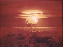 Mushroom cloud from the largest nuclear test the United States ever conducted, Castle Bravo.
From 1946 to 1958, as the site of the Pacific Proving Grounds, the U.S. tested 67 nuclear weapons in the Marshall Islands,[15] including the largest nuclear test the U.S. ever conducted, Castle Bravo.[16] In 1956, the Atomic Energy Commission regarded the Marshall Islands as "by far the most contaminated place in the world".[17]
Nuclear claims between the U.S. and the Marshall Islands are ongoing, and health effects from these nuclear tests linger.[16] Project 4.1 was a medical study conducted by the United States of those residents of the Bikini Atoll exposed to radioactive fallout. From 1956 to August 1998, at least $759 million was paid to the Marshallese Islanders in compensation for their exposure to U.S. nuclear testing.[18]
With the 1952 test of the first U.S. hydrogen bomb, code named "Ivy Mike", the island of Elugelab in the Enewetak atoll was destroyed.
Independence
In 1979, the Government of the Marshall Islands was officially established and the country became self-governing.
In 1986, the Compact of Free Association with the United States entered into force, granting the Republic of the Marshall Islands (RMI) its sovereignty. The Compact provided for aid and U.S. defense of the islands in exchange for continued U.S. military use of the missile testing range at Kwajalein Atoll. The independence procedure was formally completed under international law in 1990, when the UN officially ended the Trusteeship status.
Government
Main article: Politics of the Marshall Islands The Marshall Islands Capitol building
The government of the Marshall Islands operates under a mixed parliamentary-presidential system as set forth in its Constitution.[19] Elections are held every four years in universal suffrage (for all citizens above 18), with each of the twenty-four constituencies (see below) electing one or more representatives (senators) to the lower house of RMI’s bicameral legislature, the Nitijela. (Majuro, the capital atoll, elects five senators.) The President, who is head of state as well as head of government, is elected by the 33 senators of the Nitijela. Four of the five Marshallese presidents who have been elected since the Constitution was adopted in 1979 have been traditional paramount chiefs.[20]
Legislative power lies with the Nitijela. The upper house of Parliament, called the Council of Iroij, is an advisory body comprising twelve tribal chiefs. The executive branch consists of the President and the Presidential Cabinet, which consists of ten ministers appointed by the President with the approval of the Nitijela. The twenty-four electoral districts into which the country is divided correspond to the inhabited islands and atolls. There are currently three political parties in the Marshall Islands: Aelon Kein Ad (AKA), United People's Party (UPP), and United Democratic Party (UDP). Rule is shared by the UDP and the UPP. The following senators are in the legislative body:
- Ailinglaplap Atoll - Christopher J. Loeak (AKA), Ruben R. Zackhras (UDP)
- Ailuk Atoll - Maynard Alfred (UDP)
- Arno Atoll - Nidel Lorak (UPP), Gerald M. Zackios (UDP)
- Aur Atoll - Norman Matthew (UPP)
- Ebon Atoll - John M. Silk (UDP)
- Enewetak Atoll - Jack Ading (UPP)
- Jabat Island- Kessai H. Note (UDP)
- Jaluit Atoll - Rien R. Morris (UDP), Speaker Alvin T. Jacklick (UDP)
- Kili Island - Tomaki Juda (UDP)
- Kwajalein Atoll - Michael Kabua (AKA), Tony A. deBrum (AKA), Jeban Riklon (AKA)
- Lae Atoll - Rellong D. Lemari (AKA)
- Lib Island - Jerakoj Jerry Bejang (AKA)
- Likiep Atoll - Donald F. Capelle (UDP)
- Majuro Atoll - Wilfred I. Kendall (UDP), David Kramer (IND), Brenson S. Wase (UDP), Vice Speaker Alik J. Alik (UDP), 'H.E. President Jurelang Zedkaia' (UDP)
- Maloelap Atoll - Michael Konelios (UDP)
- Mejit Island - Dennis Momotaro (UPP)
- Mili Atoll - Kejjo Bien (UPP)
- Namdrik Atoll - Mattlan Zackhras (UDP)
- Namu Atoll - Kaiboke Kabua (AKA)
- Rongelap Atoll - Kenneth Kedi (IND)
- Ujae Atoll - Frederick H. Muller (UPP)
- Utirik Atoll - Amenta Matthew (IND)
- Wotho Atoll - David Kabua (AKA)
- Wotje Atoll - Litokwa Tomeing (UPP)
Foreign affairs and defense
The Compact of Free Association with the United States gives the U.S. sole responsibility for international defense of the Marshall Islands. It allows islanders to live and work in the United States, and establishes economic and technical aid programs.
Further information: Compact of Free AssociationGeography
Main articles: Geography of the Marshall Islands and Administrative divisions of the Marshall Islands Map of the Marshall Islands
The islands are located north of Nauru and Kiribati, east of the Federated States of Micronesia, and south of the U.S. territory of Wake Island, to which it lays claim.
The country consists of 29 atolls and 5 isolated islands. The atolls and islands form two groups: the Ratak Chain and the Ralik Chain (meaning "sunrise" and "sunset" chains). 24 of them are inhabited (see above section). The uninhabited atolls are:
- Ailinginae Atoll
- Bikar (Bikaar) Atoll
- Bikini Atoll
- Bokak Atoll
- Erikub Atoll
- Jemo Island
- Nadikdik Atoll
- Rongerik Atoll
- Toke Atoll
- Ujelang Atoll
A majority of the islands' land mass is at sea level.
Territorial claim on Wake Island
The Marshall Islands also lays claim to Wake Island. While Wake has long been administered by the United States, the Marshallese government refers to it by the name Enen-kio.
Climate
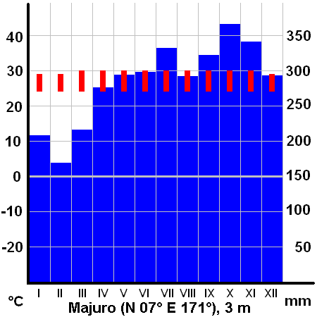
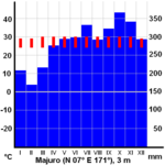 Average monthly temperatures (red) and precipitation (blue) on Majuro.
The climate is hot and humid, with a wet season from May to November. The islands occasionally suffer from typhoons. Many Pacific typhoons start in the Marshall Islands region and grow stronger as they move west toward the Mariana Islands and the Philippines.
In December 2008, the Islands were pounded several times in quick succession by long period swell waves generated by an extratropical storm.[clarification needed] These extreme waves combined with high tides, causing widespread flooding in the capital city of Majuro and other urban centres, located at 1 metre (3 ft 3 in) above sea level. On Christmas morning, the government declared a state of emergency.[21]
Economy
Main article: Economy of the Marshall IslandsThe islands have few natural resources, and imports far exceed exports.
General economic conditions
Over the past decade, GDP growth averaged 1% due to government downsizing, drought, a drop in construction, the decline in tourism and foreign investment due to Asian financial difficulties, and less income from the renewal of fishing-vessel licenses. The 2007 edition of "Doing Business," prepared by the World Bank's private sector development department, declared the Marshall Islands to be the world's "Best Performer" for its ease and low expense in hiring and firing employees. But the study gave the Marshall Islands extremely low ratings for its protection of investors and contract enforcement.[citation needed]
Labor
In 2007, the Marshall Islands joined the International Labor Organization, which means its labor laws will comply with international benchmarks. This will impact business conditions in the islands.[22]
Taxation
The income tax has two brackets, with rates of 8% and 14%. The corporate tax is 11.5%. The general sales tax is 6%. There are no property taxes.
Foreign assistance
United States government assistance is the mainstay of the economy.
Under the terms of the Amended Compact of Free Association, the U.S. will provide US$57.7 million per year to the Marshall Islands (RMI) through 2013, and then US$62.7 million through 2023, at which time a trust fund, made up of U.S. and RMI contributions, will begin perpetual annual payouts.[23]
The United States Army maintains its Ronald Reagan Ballistic Missile Defense Test Site on Kwajalein Atoll. Marshallese land owners receive rent for the base, and a large number[quantify] of Marshallese work there. The main airport was built by the Japanese during World War II, and the only tarmac road of the capital was built partly by the Taiwanese and partly by the Americans.
Agriculture
Agricultural production is concentrated on small farms. The most-important commercial crops are coconuts, tomatoes, melons, and breadfruit.
Industry
Small-scale industry is limited to handicrafts, fish processing, and copra.
Tourism
The tourist industry, a source of foreign exchange employs less than 10% of the labor force.[citation needed]
Continental Airlines serves Majuro and Kwajalein with flights to and from Honolulu,[24] and has been doing so since before 1970.[citation needed]
Fishing
Fishing has been critical to the economy of this island nation since its settlement.
In 1999, a private company built a tuna loining plant with more than 400 employees, mostly women. But the plant closed in 2005, after a failed attempt to convert it to produce tuna steaks, a process that requires half as many employees. Operating costs exceeded revenue, and the plant's owners tried to partner with the government to prevent closure. But government officials personally interested in an economic stake in the plant refused to help. After the plant closed, it was taken over by the government, which had been the guarantor of a $2 million loan to the business.
Energy
On September 15, 2007, Witon Barry (of the Tobolar Copra processing plant in the Marshall Islands capital of Majuro) said power authorities, private companies, and entrepreneurs had been experimenting with coconut oil as alternative to diesel fuel for vehicles, power generators, and ships. Coconut trees abound in the Pacific's tropical islands. Copra, the meat of the coconut, yields coconut oil (1 liter for every 6 to 10 coconuts).[25]
On July 3, 2008, the government of the Marshall Islands declared a state of emergency related to energy shortages due to a lack of financial reserves and unusually high energy costs.[citation needed]
Demographics
Main article: Demographics of the Marshall IslandsThere are 68,000 people living in the Marshall Islands. Most of these are Marshallese. The Marshallese are of Micronesian origin and migrated from Asia several thousand years ago. A minority of Marshallese have some recent Asian ancestry, mainly Japanese. Two-thirds of the nation's population lives on Majuro, the capital, and Ebeye. The outer islands are sparsely populated due to lack of employment opportunities and economic development. Life on the outer atolls is generally traditional.
The official language of the Marshall Islands is Marshallese, but is common to speak the English language.[26]
Religion
Main article: Religion in the Marshall IslandsVirtually all Marshallese are Christian. Most of them are Protestant.
Education
The Marshall Islands Ministry of Education operates the state schools in the Marshall Islands.[27]
There are 2 colleges operating in the Marshall Islands. The College of the Marshall Islands (CMI) and The University of the South Pacific.
Transportation
Main article: Transportation in the Marshall IslandsThe Marshall Islands are served by the Marshall Islands International Airport in Majuro, the Bucholz Army Airfield in Kwajalein, and other small airports and airstrips.
In 2005, Aloha Airlines canceled its flight services to the Marshall Islands.
Media
The Marshall Islands have several AM and FM radio stations.
AM: V7AD 1098 • 1557
FM: V7AD 97.9 • V7AA 104.1 (formerly 96.3)
AFRTS: AM 1224 (NPR) • 99.9 (Country) • 101.1 (Active Rock) • 102.1 (Hot AC)Health
The Marshall Islands has a low rate of leprosy.[citation needed] Nuclear tests at Enewatak have left islanders there suffering from Cancer and birth defects.[28]
Culture
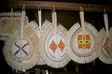 Marshallese fansMain article: Culture of the Marshall Islands
Marshallese is used by the government. Although English is an official language and is spoken widely, the population is not fluent.[citation needed] Japanese is also spoken occasionally in some areas.[citation needed] Although the ancient skills are now in decline, the Marshallese were once able navigators, using the stars and stick-and-shell charts. They are also experienced in canoe-building. They still hold annual competitions involving the unique oceanic sailing canoe, the proa.[citation needed]
The world's largest shark sanctuary
Although the Marshall islands have a population of less than 100,000 people, the government declared that an area nearly 2 million square kilometres or 750,000 square miles of ocean, shall be reserved as a shark sanctuary. This is approximately the same size as Indonesia, Mexico, Saudi Arabia and almost 8 times larger than the United Kingdom[29]
Gallery
-

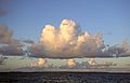
Majuro surroundings
-
Sunset from Wotho Atoll
-
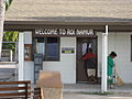
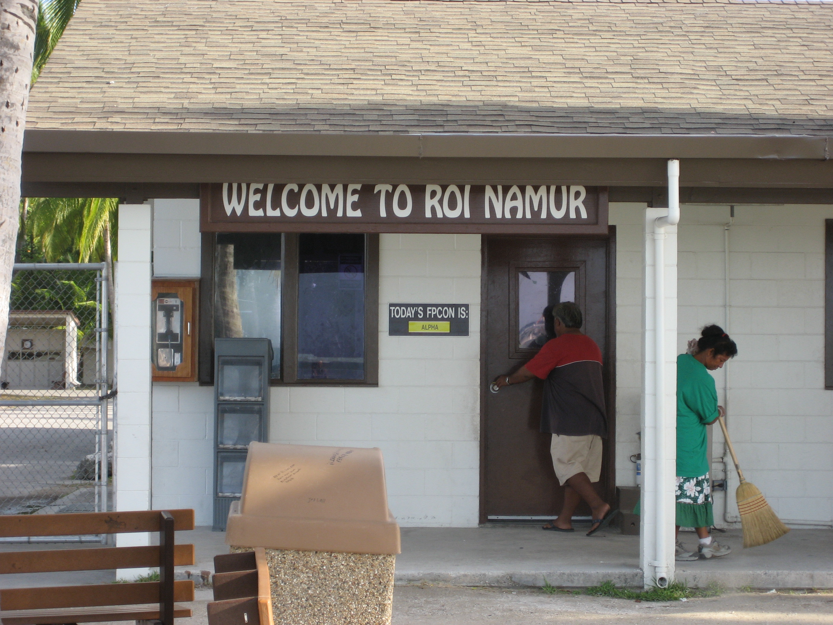
The front of the Dock Security Checkpoint at Roi-Namur
See also
- Outline of the Marshall Islands
- Index of Marshall Islands-related articles
- MIVA
References
- ^ Names of the countries of Oceania in local languages, Omniglot. Retrieved 5 March 2011.
- ^ "Marshall Islands". geonames.de. http://www.geonames.de/coumh.html. Retrieved March 5, 2011.
- ^ population.mongabay.com
- ^ Department of Economic and Social Affairs Population Division (2009) (PDF). World Population Prospects, Table A.1. 2008 revision. United Nations. http://www.un.org/esa/population/publications/wpp2008/wpp2008_text_tables.pdf. Retrieved 2009-03-12.
- ^ http://www.indexmundi.com/marshall_islands/demographics_profile.html
- ^ The History of Mankind by Professor Friedrich Ratzel, Book II, Section A, The Races of Oceania page 165, picture of a stick chart from the Marshall Islands. MacMillan and Co., published 1896.
- ^ Early Spanish Discoveries in the Pacific. By Andrew Sharp 1960: 11-3.
- ^ Wright 1951: 109-10; Sharp 1960: 19-23.
- ^ Filipiniana Book Guild 1965: 46-8, 91, 240; Sharp 1960: 36-9.
- ^ a b "Geography of the Marshall Islands". http://www.enenkio.org/adobe/GeographyMarshallIslands.pdf. Retrieved 11 June 2010.
- ^ a b c d "Marshall Islands". Pacific Institute of Advanced Studies in Development and Governance (PIAS-DG), University of the South Pacific, Suva, Fiji. http://piasdgserver.usp.ac.fj/peacenet//index.php?id=152. Retrieved 11 June 2010.
- ^ "History of the Marshall Islands". Marshall Islands Visitors Authority. http://www.visitmarshallislands.com/history.htm. Retrieved 11 June 2010.
- ^ "Marshall Islands". World Statesmen. http://www.worldstatesmen.org/Marshall_islands.htm. Retrieved 11 June 2010.
- ^ Dirk H.R. Spennemann. "Mili Island, Mili Atoll: a brief overview of its WWII sites". http://marshall.csu.edu.au/Marshalls/html/WWII/Mili.html. Retrieved 11 June 2010.
- ^ "Nuclear Weapons Test Map", Public Broadcasting Service
- ^ a b "Islanders Want The Truth About Bikini Nuclear Test". Japanfocus.org. http://japanfocus.org/-Yoichi-Funabashi/1576. Retrieved 2010-07-04.
- ^ Stephanie Cooke (2009). In Mortal Hands: A Cautionary History of the Nuclear Age, Black Inc., p. 168.
- ^ "50 Facts About Nuclear Weapons". Brookings Institution. http://www.brook.edu/FP/PROJECTS/NUCWCOST/50.HTM.
- ^ "Constitution of the Marshall Islands". Paclii.org. http://www.paclii.org/mh/legis/consol_act/cotmi363/. Retrieved 2010-07-04.
- ^ Johnson, Giff (2010-11-25). "Huge funeral recognizes late Majuro chief". Marianas Variety News & Views. http://mvariety.com/2010112432258/local-news/huge-funeral-recognizes-late-majuro-chief.php. Retrieved 2010-11-28.
- ^ "Marshall atolls declare emergency ", BBC News, 25 December 2008.
- ^ "Republic of the Marshall Islands becomes 181st ILO member State [Press releases]". Ilo.org. http://www.ilo.org/global/About_the_ILO/Media_and_public_information/Press_releases/lang--en/WCMS_083235/index.htm. Retrieved 2010-07-04.
- ^ "COMPACT OF FREE ASSOCIATION AMENDMENTS ACT OF 2003" (PDF). http://www.doi.gov/oia/Firstpginfo/laws/public%20law%20108-188,%20December%2017,%202003.pdf. Retrieved 2010-07-04.
- ^ continental.com
- ^ "Pacific Islands look to coconut power to fuel future growth". afp.google.com. 2007-09-13. http://afp.google.com/article/ALeqM5iwlwgv6YIwatWfk9HEp0bSjAiV-Q. Retrieved 2010-07-04.
- ^ "Marshall Islands Travel". Wwp.greenwichmeantime.com. 2010-03-11. http://wwp.greenwichmeantime.com/time-zone/pacific/marshall-islands/travel.htm. Retrieved 2010-07-04.
- ^ rmigovernment.org
- ^ "Marshall Islands - Economic Policy, Planning and Statistics Office - Home page". Spc.int. http://www.spc.int/prism/country/mh/stats/Social/Health/Diseases.htm. Retrieved 2010-07-04.
- ^ "Vast shark sanctuary created in Pacific". October 3, 2011. http://www.bbc.co.uk/news/science-environment-15142472.
Further reading
- Barker, H. M. (2004). Bravo for the Marshallese: Regaining Control in a Post-nuclear, Post-colonial World. Belmont, California: Thomson/Wadsworth.
- Rudiak-Gould, P. (2009). Surviving Paradise: One Year on a Disappearing Island. New York: Union Square Press.
- Niedenthal, J. (2001). For the Good of Mankind: A History of the People of Bikini and Their Islands. Majuro, Marshall Islands: Bravo Publishers.
- Carucci, L. M. (1997). Nuclear Nativity: Rituals of Renewal and Empowerment in the Marshall Islands. DeKalb: Northern Illinois University Press.
- Hein, J. R., F. L. Wong, and D. L. Mosier (2007). Bathymetry of the Republic of the Marshall Islands and Vicinity [Miscellaneous Field Studies; Map-MF-2324]. Reston, VA: U.S. Department of the Interior, U.S. Geological Survey.
- Woodard, Colin (2000). Ocean's End: Travels Through Endangered Seas. New York: Basic Books. (Contains extended account of sea-level rise threat and the legacy of U.S. Atomic testing.)
External links
- Government
- Office of the President
- Embassy of the Republic of the Marshall Islands Washington, DC official government site
- Chief of State and Cabinet Members
- General information
- Marshall Islands entry at The World Factbook
- Country Profile from New Internationalist
- Marshall Islands from UCB Libraries GovPubs
- Marshall Islands at the Open Directory Project
- Wikimedia Atlas of the Marshall Islands
- Marshall Islands travel guide from Wikitravel
- News media
- Marshall Islands Journal Weekly independent national newspaper
- Other
- 360 Panoramas and map of Marshall Islands
- Digital Micronesia - Marshalls by Dirk HR Spennemann, Associate Professor in Cultural Heritage Management
- Plants & Environments of the Marshall Islands Book turned website by Dr. Mark Merlin of the University of Hawaii
- Atomic Testing Information
- infoplease.com
- Pictures of victims of U.S. nuclear testing in the Marshall Islands on Nuclear Files.org
- "Kenner hearing: Marshall Islands-flagged rig in Gulf oil spill was reviewed in February"
Marshall Islands topics Politics 
History Geography Economy Culture Outline · Index Categories:- Marshall Islands
- Oceanian countries
- Archipelagoes of the Pacific Ocean
- English-speaking countries and territories
- Former German colonies
- Former Japanese colonies
- Freely associated states
- Island countries
- World War II sites
- Liberal democracies
- Micronesia
- Republics
- States and territories established in 1986
- Member states of the United Nations


Wikimedia Foundation. 2010.