- 1992 Atlantic hurricane season
Infobox hurricane season
Basin=Atl
Year=1992
Track=1992 Atlantic hurricane season summary.jpg
First storm formed=April 21 ,1992
Last storm dissipated=October 30 ,1992
Strongest storm name=Andrew
Strongest storm pressure=922
Strongest storm winds=150
Total depressions=9
Total storms=7
Total hurricanes=4
Total intense=1
Fatalities=66
Da
Inflated=1
five seasons=1990, 1991, 1992, 1993, 1994 The 1992 Atlantic hurricane season officially began onJune 1 ,1992 , and lasted untilNovember 30 ,1992 . These dates conventionally delimit the period of each year when mosttropical cyclone s form in theAtlantic basin . However, the season got off to an early start when Subtropical Storm One formed in April, being the first recorded storm to form in this month until the 2003 season. Although the season had an active start, it had a slow end. Total activity was below average, likely because of the 1991-1994El Niño .The most notable storm of the season was
Hurricane Andrew , the costliest natural disaster in U.S. history untilHurricane Katrina in the 2005 season, and the third Category 5 hurricane to make landfall in theUnited States . The season also had several unusual landfalls, with Hurricanes Bonnie and Charley both striking theAzores , while Tropical Storm Danielle made landfall on theDelmarva Peninsula ofVirginia .__TOC__torms
ubtropical Storm One
Infobox Hurricane Small
Basin=Atl
Type=subtropical
Track=1992 Atlantic subtropical storm 1 track.pngApril 21
Dissipated=April 24
1-min winds=45
Pressure=1002subtropical storm in April, before the official start of the season. The unnamed subtropical storm formed onApril 21 in the southwestAtlantic and dissipated onApril 24 . This was, according to the NHC, the first recorded storm to form in April; there would be Tropical Storm Ana in April of the 2003 season.Tropical Depression One
Infobox Hurricane Small
Basin=Atl
Track=
Formed=June 25
Dissipated=June 26
1-min winds=30
Pressure=1007A tropical depression formed in the western Caribbean onJune 25 , striking the west coast ofFlorida . Local rainfall amounts exceeded 20 inches. [Hydrometeoroogical Prediction Center. [http://www.hpc.ncep.noaa.gov/tropical/rain/td1of1992rain.gifTropical Depression One - 1992.] Retrieved on2007-02-24 .] Operationally, this system was designated Tropical Depression Two by the National Hurricane Center, due to the earlier subtropical storm, creating a flurry of activity amongst the media. The National Meteorological Center (NMC) used the designation of Tropical Depression One, which likely added to the confusion. Policy at the time kept subtropical and tropical cyclones on different numbering systems, which led to a second Tropical Depression Two later in June, creating even more media queries later in the month when that system formed. [ftp://ftp.nhc.noaa.gov/pub/storm_archives/atlantic/atl1992/td2/tropdisc/nal0392.001]Tropical Depression Two
Infobox Hurricane Small
Basin=Atl
Track=2-L 1992 track.pngJuly 24
Dissipated=July 26
1-min winds=30
Pressure=1015New York and southernNew England formed a mesoscale convective vortex, which fired new thunderstorm activity each day as it moved across the northern Atlantic. Once it reached mid-ocean, an increasingly northerly steering flow dropped the system down into the subtropics to the east ofBermuda , and it maintained decent organization. A small low pressure system embedded within a large, and relatively strong, surface high, reconnaissance found minimal tropical storm force winds with a rather high pressure of 1016 mbar at the center. The decision at the time was to keep the system a tropical depression due to its higher-than-standard atmosphere pressure. The system moved westward, eventually shearing to death as it raced ahead of a frontal zone.The system was designated Tropical Depression Two because the policy on naming had been clarified after Tropical Depression One. Additional confusion was caused because of the apparent naming of two systems as "Tropical Depression Two".
Hurricane Andrew
Infobox Hurricane Small
Basin=Atl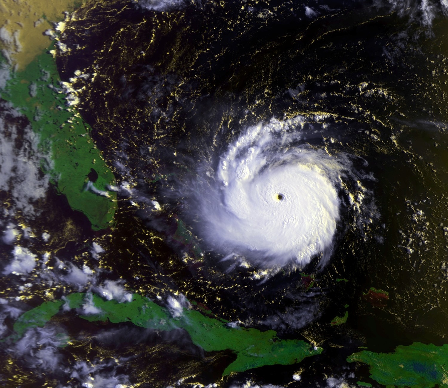
Track=Andrew 1992 track.pngAugust 16
Dissipated=August 28
1-min winds=150
Pressure=922Africa onAugust 14 , and organized into a tropical depression on August 16 while located about halfway between theWindward Islands and the coast of Africa. It moved to the west-northwest, and strengthened into Tropical Storm Andrew on August 17. After reaching winds of 50 mph, strong southwesterly shear weakened the storm, and by August 20 it weakened to a minimal storm with a pressure of 1015mbar . It bypassed theLesser Antilles completely, and turned to the west in response to the building of a high pressure system to the north.Upon turning to the west, a trough of low pressure positioned to the southwest of Andrew created an environment with little vertical shear and well-defined outflow. The storm quickly intensified due to its small size, and became a hurricane on
August 22 . Andrew rapidly intensified under ideal conditions for development, and on August 23 the hurricane peaked with winds of 175 mph. It crossed theBahamas at that intensity, weakened slightly, and re-intensified to a 165 mph Category 5 hurricane before making landfall nearHomestead, Florida . It weakened slightly over the state to a 135 mph hurricane, but restrengthened to a 145 mph hurricane over the Gulf of Mexico. A strong mid-latitude trough turned Andrew northward, where it greatly weakened before hitting west ofMorgan City, Louisiana on August 26 as a 115 mph Category 3 hurricane. It turned northeastward, and dissipated overTennessee on August 28.Hurricane Andrew was by far the most intense hurricane of the year, and one of only two Category 5 hurricanes in the 1990s (the other was Mitch in 1998). The death toll of Andrew was only 26, largely due the well-executed evacuations. However, it caused a total of $26 billion in damage (1992 dollars), including $25 billion in Dade County (now Miami-Dade County) in Florida, $1 billion in
Louisiana , and $250 million in the Bahamas, making it the most expensive hurricane in history untilHurricane Katrina surpassed it in 2005.Hurricane Bonnie
Infobox Hurricane Small
Basin=Atl
Track=Bonnie 1992 track.pngSeptember 17
Dissipated=September 30
1-min winds=95
Pressure=965September 17 . The depression, Tropical Depression Four, became Tropical Storm Bonnie in the early morning hours on the 18th, and became a hurricane in the early evening hours on the same day. Bonnie reached its peak intensity onSeptember 21 when it reached Category 2 status on theSaffir-Simpson Hurricane Scale with top sustained winds of 110mph . Strong upper-level westerly winds weakened the storm onSeptember 23 as it drifted southwest. It weakened to tropical depression status then strengthened again onSeptember 27 , though remained disorganized. On the 27th, the deep convection diminished enough that theNational Hurricane Center discontinued advisories. [http://www.nhc.noaa.gov/archive/storm_wallets/atlantic/atl1992/bonnie/tropdisc/nal0592.040] It moved to the east and re-organized into a tropical storm on the 28th. [http://www.nhc.noaa.gov/archive/storm_wallets/atlantic/atl1992/bonnie/tropdisc/nal0592.041] Bonnie briefly reached winds of 70 mph before weakening due to vertical shear while passing through theAzores Islands . The storm again became extratropical onSeptember 30 to the east of the Azores.Bonnie did affect the
Azores but there were no damage reports received. However, one man was killed by a rock fall on the island of São Miguel.Fact|date=February 2007Hurricane Charley
Infobox Hurricane Small
Basin=Atl
Track=Charley 1992 track.pngSeptember 21
Dissipated=September 27
1-min winds=95
Pressure=965September 21 about 630 miles southwest of the Azores. It strengthened and became Tropical Storm Charley on the 22nd, and became a hurricane in the early morning hours onSeptember 23 . At peak intensity the storm reached 110mph winds onSeptember 24 atCategory 2 status. Charley drifted southwest onSeptember 25 and then moved northeast and accelerated. Charley weakened onSeptember 26 as it moved into cooler waters. It weakened further onSeptember 27 and dissipated late in the day. There was no damage or casualties related to Charley.Tropical Storm Danielle
Infobox Hurricane Small
Basin=Atl
Track=Danielle 1992 track.pngSeptember 22
Dissipated=September 26
1-min winds=55
Pressure=1001September 18 off theU.S. East Coast . It became a tropical storm on the 22nd and moved parallel to the seaboard. The storm made landfall inMaryland on theDelmarva Peninsula and continued northwest where it dissipated. Danielle was a very rare tropical cyclone to make landfall inVirginia , one of only a few.Two deaths were reported as a result of Danielle: a sailboat was battered and sunk by high seas off the coast of
New Jersey .Tropical Depression Seven
Infobox Hurricane Small
Basin=Atl
Track=7-L 1992 track.pngSeptember 25
Dissipated=October 1
1-min winds=30
Pressure=1008Africa onSeptember 23 . The wave remained poorly organized until the 25th, when the system began organizing and becoming Tropical Depression Seven. The depression moved to the west-northwest initially, but after shear exposed the center the system turned more to the northwest. The depression moved northward while cycling between intensification and weakening, reaching a minimum pressure of 1008 mb on the 30th. The depression dissipated onOctober 1 .Since Seven remained far from land, no damage was reported in connection to the depression.
Tropical Storm Earl
Infobox Hurricane Small
Basin=Atl
Track=Earl 1992 track.pngSeptember 26
Dissipated=October 3
1-min winds=55
Pressure=990September 18 . OnSeptember 27 the system became a tropical depression 345 miles north ofHispaniola . The storm moved northwest toward theBahamas and became stationary, where it began to strengthen. It became Tropical Storm Earl onSeptember 29 . It moved east and reached its peak intensity of 60 mph winds in the late evening hours ofOctober 1 .There were no casualties or damage reported as a result of Earl.
Hurricane Frances
Infobox Hurricane Small
Basin=Atl
Track=Frances 1992 track.pngOctober 23
Dissipated=October 27
1-min winds=75
Pressure=976Bermuda onOctober 18 . Frances strengthened to tropical storm status onOctober 23 , and it reached its peak intensity on the 24th with winds of 85mph . Frances moved northeast into cooler waters and weakened substantially for the next two days. It becameextratropical onOctober 27 .A sailor was classified as missing and one was injured on a sailboat.
Other storms
A
polar low formed offshore the Mid-Atlantic States and moved up Chesapeake Bay into northern Virginia, with surprisingly warm mid-level temperatures and an eye feature, which was quite pronounced on WSR-88D radar imagery, and wind gusts to 87 mph/140 km/h at Chincoteague,Virginia onJanuary 4 . NASA indicated the existence of another possible tropical storm onMay 16 . It neared Bermuda and at its peak, had a well developed eye. Despite its organization, it was not recognized by the NHC and went unrecorded. [ [http://www.camex4.com/photo0016.html Marshall Space Flight Center News - CAMEX-4 Hurricane News and Hurricane Photos ] ] There was an additional suspicious cyclone that rapidly formed in mid-September offshore the Mid-Atlantic, forming an eye as it moved a few hundred miles offshore New England, before strikingSable Island ,Nova Scotia . [ [http://www.class.noaa.gov/VisData/browse/03m/02023742_C4_406680_945346_full.gif] Dead link|date=August 2008] One, if not all, of these cyclones could be included into the hurricane database, when theAtlantic hurricane reanalysis reaches 1992 (it is currently complete through 1920).Accumulated Cyclone Energy (ACE) Rating
The table on the right shows the ACE for each storm in the season. The ACE is, broadly speaking, a measure of the power of the hurricane multiplied by the length of time it existed for, so hurricanes that lasted a long time have higher ACEs. Subtropical Storm One is not included, as subtropical cyclones do not receive an ACE rating.
torm names
The following names were used for named storms that formed in the north Atlantic in 1992. The names not retired from this list were used again in the 1998 season. This is the same list used for the 1986 season. Names that were not assigned are marked in tcname unused.
Retirement
The
World Meteorological Organization retired one name in the spring of 1993: Andrew. It was replaced in the 1998 season with Alex.eason Effects
This is a table of the storms in 1992 and their landfall(s), if any. Deaths in parentheses are additional and indirect (an example of an indirect death would be a traffic accident), but are still storm-related. Damage and deaths include totals while the storm was extratropical or a wave or low.TC stats table end|num-cyclones-text=12 cyclones|dates=April 21 – October 30|max-winds=175|min-press=922
num-cyclones-text=10 cyclones|tot-ace=75.13|num-landfalls=4|tot-da
26,252|tot-deaths=66 (94)ee also
*
List of Atlantic hurricanes
*List of Atlantic hurricane seasons
*1992 Pacific hurricane season
*1992 Pacific typhoon season
*1992 North Indian Ocean cyclone season
*Southern Hemisphere tropical cyclone seasons: 1991–92, 1992–93References
External links
* [http://www.aoml.noaa.gov/general/lib/lib1/nhclib/mwreviews/1992.pdf Monthly Weather Review]
* [ftp://ftp.nhc.noaa.gov/pub/storm_archives/atlantic/atl1992/ Detailed information on storms from the 1992 Atlantic hurricane season]
* [http://www.hpc.ncep.noaa.gov/tropical/rain/1992.html U.S. Rainfall information concerning 1992 tropical cyclones]

Wikimedia Foundation. 2010.