- Inner Mongolia
-
Coordinates: 44°N 113°E / 44°N 113°E
Inner Mongolia Autonomous Region
Nei Mongol Autonomous RegionChinese : 内蒙古自治区 Nèi Měnggǔ Zìzhìqū Mongolian :  ,
,Öbür mongγol-un öbertegen zasaqu orun[1] Abbreviations: 内蒙 or 内蒙古[2] (pinyin: Nèi Měng or Nèi Měnggǔ) 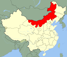
Origin of name From the Mongolian öbür monggol, where öbür can mean south, inner, breast. Administration type Autonomous region Capital Hohhot Largest city Baotou CPC Ctte Secretary Hu Chunhua Chairman Bagatur Area 1,183,000 km2 (457,000 sq mi) (3rd) - Latitude 37° 24' to 53° 20' N - Longitude 097° 05' to 126° 05' E Population (2010)
- Density24,706,321[3] (23rd)
20.2 /km2 (52 /sq mi) (28th)GDP (2010)
- per capitaCNY 1.17 trillion (US$172.1 billion) (15th)
CNY 37,287 (7th)HDI (2008) 0.803 (high) (13th) Ethnic composition Han - 79%
Mongol - 17%
Manchu - 2%
Hui - 0.9%
Daur - 0.3%Spoken dialects {{{Dialects}}} Prefectural level 12 divisions County level 101 divisions Township level* 1425 divisions ISO 3166-2 CN-15 Official website
http://www.nmg.gov.cn
(Simplified Chinese)Source for population and GDP data: 《中国统计年鉴—2005》 China Statistical Yearbook 2005Source for nationalities data:
ISBN 7503747382《2000年人口普查中国民族人口资料》 Tabulation on nationalities of 2000 population census of China*As at December 31, 2004
ISBN 7105054255Template ■ Discussion ■ WikiProject China Inner Mongolia (Mongolian: s
 , Öbür Monggol and c Өвөр Монгол, Övör Mongol; Chinese: 内蒙古; pinyin: Nèi Měnggǔ, but officially romanized to Nei Mongol) is an autonomous region of the People's Republic of China, located in the northern region of the country. Inner Mongolia shares an international border with the countries of Mongolia and the Russian Federation. Its capital is Hohhot and the largest city is Baotou.
Inner Mongolia Autonomous Region was established in 1947 on the area of former Republic of China provinces of Suiyuan, Chahar, Rehe, Liaopeh and Hsingan. It is the third-largest subdivision of China spanning about 1,200,000 km² (463,000 sq mi) or 12% of China's total land area. It has a population of about 24 million as of 2004. The majority of the population in the region are Han Chinese, with a substantial Mongol minority. The official languages are Chinese and Mongolian, the latter written in the Mongolian script, as opposed to the Mongolian Cyrillic alphabet used in the Mongolian state.
Contents
Name
In Chinese, the region is known as "Inner Mongolia", where the terms of "Inner/Outer" are derived from Manchu dorgi/tulergi (cf. Mongolian dotugadu/gadagadu). Inner Mongolia is distinct from Outer Mongolia, which was a term used by the Republic of China and previous governments to refer to what is now the independent state of Mongolia plus the Republic of Tuva in Russia. In Mongolian, the region was called Dotugadu monggol during the time of the Manchu Empire and was renamed into Öbür monggol in 1947, öbür meaning the southern side of a mountain, while the Chinese term nei menggu was retained. Some Mongolians use the name "Southern Mongolia" in English as well.[4]
History
See also: History of MongoliaThroughout most of history and time, central and western Inner Mongolia, especially the Hetao region, alternated in control between Chinese agriculturalists in the south and Xiongnu, Xianbei , Khitan, Jurchen, Tujue, and Mongol nomads of the north. Eastern Inner Mongolia is properly speaking a part of Manchuria, and its historical narrative consists more of alternations between different groups there rather than the struggle between nomads and Chinese agriculturalists.
During the Zhou Dynasty, central and western Inner Mongolia (the Hetao region and surrounding areas) were inhabited by nomadic peoples such as the Loufan, Linhu, and Dí, while eastern Inner Mongolia was inhabited by the Donghu. During the Warring States Period, King Wuling (340–295 BC) of the state of Zhao based in what is now Hebei and Shanxi provinces pursued an expansionist policy towards the region. After destroying the Dí state of Zhongshan in what is now Hebei province, he defeated the Linhu and Loufan and created the commandery of Yunzhong near modern Hohhot. King Wuling of Zhao also built a long wall stretching through the Hetao region. After Qin Shihuang created the first unified Chinese empire in 221 BC, he sent the general Meng Tian to drive the Xiongnu from the region, and incorporated the old Zhao wall into the Qin Dynasty Great Wall of China. He also maintained two commanderies in the region: Jiuyuan and Yunzhong, and moved 30,000 households there to solidify the region. After the Qin Dynasty collapsed in 206 BC, these efforts were abandoned.
During the Western Han Dynasty, Emperor Wu sent the general Wei Qing to reconquer the Hetao region from the Xiongnu in 127 BC. After the conquest, Emperor Wu continued the policy of building settlements in Hetao to defend against the Xiong-Nu. In that same year he established the commanderies of Shuofang and Wuyuan in Hetao. At the same time, what is now eastern Inner Mongolia was controlled by the Xianbei, who would later on eclipse the Xiongnu in power and influence.
During the Eastern Han Dynasty (25–220 AD), Xiongnu who surrendered to the Han Dynasty began to be settled in Hetao, and intermingled with the Han immigrants in the area. Later on during the Western Jin Dynasty, it was a Xiongnu noble from Hetao, Liu Yuan, who established the Han Zhao kingdom in the region, thereby beginning the Sixteen Kingdoms period that saw the disintegration of northern China under a variety of Han and non-Han (including Xiongnu and Xianbei) regimes.
The Sui Dynasty (581–618) and Tang Dynasty (618–907) re-established a unified Chinese empire, and like their predecessors they conquered and settled people into Hetao, though once again these efforts were aborted when the Tang empire began to collapse. Hetao (along with the rest of what now consists Inner Mongolia) was then taken over by the Khitan Empire (Liao Dynasty), founded by the Khitans, a nomadic people originally from what is now the southern part of Manchuria and eastern Inner Mongolia. They were followed by the Western Xia of the Tanguts, who took control of what is now the western part of Inner Mongolia (including western Hetao) . The Khitans were later replaced by the Jurchens, precursors to the modern Manchus, who established the Jin Dynasty over Manchuria and northern China.
After Genghis Khan unified the Mongol tribes in 1206 and founded the Mongol Empire, the Tangut Western Xia empire was ultimately conquered in 1227, and the Jurchen Jin Dynasty fell in 1234. In 1271, Genghis grandson Khubilai established the Yuan Dynasty. Khubilai's summer capital Shangdu (aka Xanadu) was located near present-day Dolonnor. During that time Ongud and Khunggirad peoples dominated the area of Inner Mongolia. After the Yuan Dynasty was evicted by the Han -led Ming Dynasty in 1368, the Ming rebuilt the Great Wall of China at its present location, which roughly follows the southern border of the modern Inner Mongolia Autonomous Region (though it deviates significantly at the Hebei- Inner Mongolia border). The Ming established the Three Guards composed of the Mongols there. After the Tumu incident in 1450, Mongols flooded south from Northern Mongolia to Southern Mongolia. Thus from then on until 1635, Inner Mongolia was the center of the Northern Yuan Dynasty.[5]
 Part of the Great Wall of China
The Manchus gained control of the Inner Mongolian tribes in the early 17th century, then invaded Ming Dynasty in 1644, bringing it under the control of their newly established Qing Dynasty. Under the Qing Dynasty (1636–1912), Greater Mongolia was administered in a different way for each region:
- "Outer Mongolia": This region corresponds to the modern state of Mongolia, plus the Russian-administered region of Tannu Uriankhai, and a part of northern Xinjiang. It includes the four leagues (aimag) of the Khalkha Mongols north of Gobi, as well as the Tannu Uriankhai and Khovd regions in northwestern Mongolia, which were overseen by the General of Uliastai at the city of Uliastai.
- "Inner Mongolia": This region corresponds to most of modern Inner Mongolia and some neighbouring areas in Liaoning and Jilin provinces. The banners and tribes in this region came under six leagues (chuulghan): Jirim , Juu Uda, Josutu, Xilingol, Ulanqab, and Yeke Juu.
- "Taoxi Mongolia": The Alashan Öölüd and Ejine Torghuud banners were separate from the aimags of Outer Mongolia and the chuulghans of Inner Mongolia. This is equivalent to modern-day Alxa League, the westernmost part of what is now Inner Mongolia.
- The Chahar Eight Banners were controlled by the military commander of Chahar (now Zhangjiakou). Their extent corresponds to southern Ulanqab and Bayan Nur in modern Inner Mongolia, plus the region around Zhangjiakou in Hebei province. At the same time, the jurisdiction of some border departments of Zhili and Shanxi provinces also overlapped into this region.
- The Guihua Tümed banner was controlled by the military commander of Suiyuan (now Hohhot). This corresponds to the vicinities of the modern city of Hohhot. At the same time, the jurisdiction of some border departments of Shanxi province also overlapped into this region.
- The Hulunbuir region, in what is now northeastern Inner Mongolia, was part of the jurisdiction of the General of Heilongjiang, one of the three generals of Manchuria.
Ordinary Mongols were not allowed to travel outside their own leagues. During the eighteenth century, growing numbers of Han Chinese settlers had illegally begun to move into the Inner Mongolian steppe. By 1791 there had been so many Han Chinese settlers in the Front Gorlos Banner that the jasak had petitioned the Qing government to legalize the status of the peasants who had already settled there.[6]
During the nineteenth century, the Manchus were becoming increasingly sinicized, and faced with the Russian threat, they began to encourage Han Chinese farmers to settle in both Mongolia and Manchuria. This policy has been followed by subsequent governments. The railroads that were being built in these regions were especially useful to the Han Chinese settlers. Land was either sold by Mongol Princes, or leased to Han Chinese farmers, or simply taken away from the nomads and given to Han Chinese farmers.
During the Republic of China era, Outer Mongolia regained independence. There also existed Mongol rebellions in Inner Mongolia in the early era,[7][8] which were suppressed by the Republic of China. Inner Mongolia was reorganized into provinces:
- Rehe province was created to include the Juu Uda and Josutu leagues, plus the Chengde area in what is now northern Hebei.
- Chahar province was created to include Xilingol league as well as much of the former territory of the Eight Banners.
- Suiyuan province was created to include Ulanqab league, Yeke Juu league, and the Hetao region (former Guihua Tümed territory).
- Hulunbuir stayed within Heilongjiang in Manchuria, which had become a province.
- Most of Jirim league came under the new province of Fengtian in southern Manchuria.
- Taoxi Mongolia, i.e. Alashan and Ejine leagues, was incorporated into neighbouring Gansu province. Later on Ningxia province was split out of northern Gansu, and Taoxi Mongolia became part of Ningxia.
Some Republic of China maps still show this structure.
Manchuria came under the control of the Japanese puppet state Manchukuo in 1931, taking the Mongol areas in the Manchurian provinces (i.e. Hulunbuir and Jirim leagues) along. Rehe was also incorporated into Manchukuo in 1933, taking Juu Uda and Josutu leagues along with it. These areas were administered by Manchukuo until the end of World War II in 1945.
In 1937, open war broke out between the Republic of China and the Empire of Japan. On December 8, 1937, Mongolian Prince De Wang declared the independence of the remaining parts of Inner Mongolia (i.e. the Suiyuan and Chahar provinces) as Mengkiang or Mengkukuo, and signed close agreements with Manchukuo and Japan. The capital was established at Zhangbei (now in Hebei province), with the puppet government's control extending as far west as the Hohhot region. In August 1945, Mengkiang was taken by Soviet and Outer Mongolian troops during Manchurian Strategic Offensive Operation. Despite a considerable movement among Inner Mongolia's Mongols(who comprised then around 15% of Inner Mongolia's population, while Han Chinese around 83%) for unification with Outer Mongolia, Inner Mongolia remained part of China.
Following the end of World War II, the Chinese Communists gained control of Manchuria with decisive Soviet support, and established the Inner Mongolia Autonomous Region in 1947. Initially the autonomous region included just the Hulunbuir region. Over the next decade, as the communists established the People's Republic of China and consolidated control over mainland China, Inner Mongolia was expanded westwards to include five of the six original leagues (except Josutu League, which remains in Liaoning province), the northern part of the Chahar region, by then a league as well (southern Chahar remains in Hebei province), the Hetao region, and the Alashan and Ejine banners. Eventually, near all areas with sizeable Mongol populations were incorporated into the region, giving present-day Inner Mongolia its elongated shape. The leader of Inner Mongolia during that time, as both regional CPC secretary and head of regional government, was Ulanhu.
During the Cultural Revolution, the administration of Ulanhu was purged, and a wave of repressions against the Mongol population of the autonomous region was initiated.[9] In 1969 much of Inner Mongolia was distributed among surrounding provinces, with Hulunbuir divided between Heilongjiang and Jilin, Jirim going to Jilin, Juu Uda to Liaoning, and the Alashan and Ejine region divided among Gansu and Ningxia. This was reversed in 1979.
Geography
 Grasslands in the region
Officially Inner Mongolia is classified as one of the provincial-level divisions of North China, but its great stretch means that parts of it belong to Northeast China and Northwest China as well. It borders eight provincial-level divisions in all three of the aforementioned regions (Heilongjiang, Jilin, Liaoning, Hebei, Shanxi, Shaanxi, Ningxia, and Gansu), tying with Shaanxi for the greatest number of bordering provincial-level divisions. Most of its international border is with Mongolia, which, in Chinese, is sometimes called "Outer Mongolia" (外蒙古), while a small portion is with Russia.
Due to its size, Inner Mongolia has a wide variety of temperatures but the following climactic characteristics apply provincial-wide: four-season monsoon-influenced climate, with long, cold, very dry winters, quick and dry springtime and autumnal transitions (the former of which is prone to sandstorms), and very warm to hot summers. Generally, cold arid or steppe climatic regimes (Köppen BWk, BSk, respectively) dominate, but there are some areas classified as humid continental (Köppen Dwb), located primarily in higher elevations and in the northeast, and subarctic (Köppen Dwc), located in the far north.[10]
Administrative divisions
Inner Mongolia is divided into 12 prefecture-level divisions. Until the late 1990s, most of Inner Mongolia's prefectural regions were known as Leagues (Chinese: 盟), a usage retained from Mongol divisions of the Qing Dynasty. Similarly, county-level divisions are often known as Banners (Chinese: 旗). Since the 1990s, numerous Leagues have converted into prefecture-level cities, although Banners remain. The restructuring led to the conversion of primate cities in most leagues to convert to districts administratively (Hailar, Jining, and Dongsheng). Some newly founded prefecture-level cities have chosen to retain the original name of League (Hulunbuir, Bayan Nur, and Ulanqab), some have adopted the Chinese name of their primate city (Chifeng, Tongliao), and one League, Ikh Juu, simply renamed itself Ordos. Despite these recent administrative changes, there is no indication that the Alxa, Hinggan, and Xilin Gol Leagues will convert to prefecture-level cities in the near future.
Map # Conventional[11] Hanzi Hanyu Pinyin Mongolian Transcription from Mongolian Administrative Seat 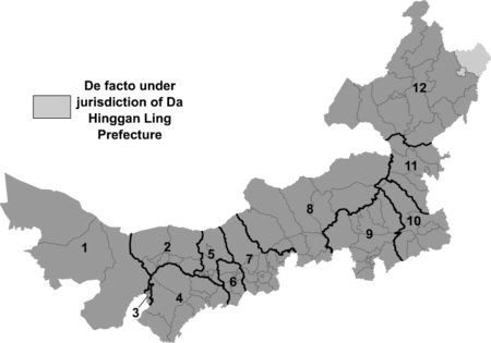
— Prefecture-level city — 2 Bayan Nur 巴彦淖尔市 Bāyànnào'ěr shì 

Bayan Naγur Qota Linhe District 3 Wuhai 乌海市 Wūhǎi shì 
Üqai Qota Haibowan District 4 Ordos 鄂尔多斯市 È'ěrduōsī shì 
Ordos Qota Dongsheng District 5 Baotou 包头市 Bāotóu shì 
Buγutu Qota Kundulun District 6 Hohhot 呼和浩特市 Hūhéhàotè shì 
Kökeqota Huimin District 7 Ulanqab 乌兰察布市 Wūlánchábù shì 
Ulaγančabu Qota Jining District 9 Chifeng 赤峰市 Chìfēng shì 
Ulaγanqada Qota Hongshan District 10 Tongliao 通辽市 Tōngliáo shì n
/
aTöngliyao Qota
Bayisingtu QotaHorqin District 12 Hulunbuir 呼伦贝尔市 Hūlúnbèi'ěr shì 
Kölün Buir Qota Hailar District — League — 1 Alxa 阿拉善盟 Ālāshàn méng 
Alaša Ayimaγ Alxa Left Banner 8 Xilin Gol 锡林郭勒盟 Xīlínguōlè méng 
Sili-yin Ɣool Ayimaγ Xilinhot 11 Hinggan 兴安盟 Xīng'ān méng 
Kingγan Ayimaγ Ulan Hot Many of the prefecture-level cities were converted very recently from leagues.
The twelve prefecture-level divisions of Inner Mongolia are subdivided into 101 county-level divisions, including twenty-one districts, eleven county-level cities, seventeen counties, forty-nine banners, and three autonomous banners. Those are in turn divided into 1425 township-level divisions, including 532 towns, 407 townships, 277 sumu, eighteen ethnic townships, one ethnic sumu, and 190 subdistricts.
See the List of administrative divisions of Inner Mongolia for a complete list of county-level divisions.
Economy
Farming of crops such as wheat takes precedence along the river valleys. In the more arid grasslands, herding of goats, sheep and so on is a traditional method of subsistence. Forestry and hunting are somewhat important in the Greater Khingan ranges in the east. Reindeer herding is carried out by Evenks in the Evenk Autonomous Banner. More recently, growing grapes and winemaking have become an economic factor in the Wuhai area.
Inner Mongolia has abundance of resources especially coal, cashmere, natural gas, rare earth elements, and has more deposits of naturally occurring niobium, zirconium and beryllium than any other province-level region in China. However in the past, the exploitation and utilisation of resources were rather inefficient, which resulted in poor returns from rich resources. Inner Mongolia is also an important coal production base, with more than a quarter of the world's coal reserves located in the province[12]. It plans to double annual coal output by 2010 (from the 2005 volume of 260 million tons) to 500 million tons of coal a year.[13]
 Inner Mongolia Gymnasium
Industry in Inner Mongolia has grown up mainly around coal, power generation, forestry-related industries, and related industries. Inner Mongolia now encourages six competitive industries: energy, chemicals, metallurgy, equipment manufacturing, processing of farm (including dairy) produce, and high technology. Well-known Inner Mongolian enterprises include companies such as ERDOS, Yili, and Mengniu.
The nominal GDP of Inner Mongolia in 2010 was 1.16 trillion yuan (US$172.1 billion), a growth of 16.9% from 2008, with an average annual increase of 20% from the period 2003-2007. Its per capita GDP reached 37,287 yuan (US$5,460) in 2009. In 2008, Inner Mongolia's primary, secondary, and tertiary industries were worth 90.7 billion yuan, 427.1 billion yuan, and 258.4 billion yuan respectively. The urban per capita disposable income and rural per capita net income were 14,431 yuan and 4,656 yuan, up 16.6% and 17.8% respectively.[14]
As with much of China, economic growth has led to a boom in construction, including new commercial development and large apartment complexes.
In addition to it's large reserves of natural resources, Inner Mongolia also has the largest usable wind power capacity in China[15] thanks to strong winds which develop in the province's grasslands. Some private companies have set up wind parks in parts of Inner Mongolia such as Bailingmiao, Hutengliang and Zhouzi.
Economic and Technological Development Zones
- Baotou National Rare Earth Hi-Tech Industrial Development Zone[16]
- Erenhot Border Economic Cooperation Area
- Hohhot Export Processing Zone
Hohhot Export Processing Zone was established on June, 21st 2002 by State Council, which is located in the west of the Hohhot, with a planning area of 2.2 sqkm. Industries encouraged in the export processing zone include Electronics Assembly & Manufacturing, Telecommunications Equipment, Garment and Textiles Production, Trading and Distribution, Biotechnology/Pharmaceuticals, Food/Beverage Processing, Instruments & Industrial Equipment Production, Medical Equipment and Supplies, Shipping/Warehousing/Logistics, Heavy Industry.[17]
- Hohhot Economic and Technological Development Zone
- Hohhot Export Processing Zone
- Manzhouli Border Economic Cooperation Area
Government and politics
Main article: Politics of Inner MongoliaUnder the Constitution of the People's Republic of China, articles 112-122, autonomous regions have limited autonomy in both the political and economic arena. Autonomous regions have more discretion in administering economic policy in the region in accordance with national guidelines. Structurally, the Chairman — who legally must be an ethnic minority and is usually ethnic Mongolian — is always kept in check by the Communist Party Regional Committee Secretary, who is usually from a different part of China (to reduce corruption) and Han Chinese. The current party secretary is Hu Chunhua.[18] The Inner Mongolian government and its subsidiaries follow roughly the same structure as that of a Chinese province. With regards to economic policy, as a part of increased federalism characteristics in China, Inner Mongolia has become more independent in implementing its own economic roadmap.
Demographics
See also: List of Chinese ethnic groupsWhen the autonomous region was established in 1947, Han Chinese comprised 83.6% of the population, while the Mongols comprised 14.8% of the population.[19] By the year 2000, the percentage of Han Chinese fell to 79.17%. While the Hetao region along the Yellow River has always alternated between farmers from the south and nomads from the north, the most recent episode of Han Chinese migration began in the early 18th century with encouragement from the Qing Dynasty, and continued into the 20th century. Han Chinese live mostly in the Hetao region as well as various population centres in central and eastern Inner Mongolia. Over 70% of Mongols are concentrated in less than 18% of Inner Mongolia's territory (Hinggan League, and prefectures Tongliao and Chifeng).
Mongols are the second largest ethnic group, comprising 17.13% of the population, an increase of 2.33% since 1947. They include many diverse Mongolian-speaking groups; groups such as the Buryats and the Oirats are also officially considered to be Mongols in China. Many of the traditionally nomadic Mongols have settled in permanent homes as their pastoral economy was collectivized during the Maoist Era.
Other ethnic groups include the Daur, the Evenks, the Oroqen, the Hui, the Manchus, and the Koreans.
Ethnic groups in Inner Mongolia, 2000 census[20] Ethnicity Population Percentage Han Chinese 18,465,586 79.17% Mongol 3,995,349 17.13% Manchu 499,911 2.14% Hui 209,850 0.900% Daur 77,188 0.331% Evenks 26,201 0.112% Koreans 21,859 0.094% Russians 5,020 0.022% Excludes members of the People's Liberation Army in active service.
Culture
See also: Culture of Mongolia and Music of MongoliaThe Han Chinese of Inner Mongolia speak a variety of dialects, depending on the region. The eastern parts tend to speak Northeastern Mandarin, which belongs to the Mandarin group of dialects; those in the central parts, such as the Huang He valley, speak varieties of Jin, another subdivision of Chinese, due to its proximity to other Jin-speaking areas in China such as the Shanxi province. Cities such as Hohhot and Baotou both have their unique brand of Jin Chinese which are sometimes incomprehensible with dialects spoken in northeastern regions such as Hailar.
Mongols in Inner Mongolia speak a variety of dialects of the Mongolian language, including Chahar, Bairin, Ordos, Ejin-Alxa, Barghu-Buryat, etc.; the standard pronunciation of Mongolian in China is based on the Chahar dialect of the Plain Blue Banner, located in central Inner Mongolia. This is different from independent Mongolia, where the standard pronunciation is based on the Khalkha dialect. The Daur, Evenks, and Oroqin speak their own respective languages.
By law, all street signs, commercial outlets, and government documents must be bilingual, written in Mongolian and Chinese. There are three Mongolian TV channels in the Inner Mongolia Satellite TV network. In public transportation, all announcements are to be bilingual. Many ethnic Mongols, especially the young, speak fluent Chinese. Mongolian is receding urban areas. But rural ethnic Mongols have kept their traditions. In terms of written language, Inner Mongolia has retained the classic Mongol written script as opposed to Outer Mongolia's adoption of the Cyrillic alphabet.
The vast grasslands have long symbolised Inner Mongolia. Mongolian art often depicts the grassland in an uplifting fashion and emphasizes Mongolian nomadic traditions. The Mongols of Inner Mongolia still practice their traditional arts. Inner Mongolian cuisine has Mongol roots and consists of dairy-related products and hand-held lamb (手扒肉). In recent years, franchises based on Hot pot have appeared Inner Mongolia, the most famous of which is Xiaofeiyang (小肥羊). Famous Inner Mongolian commercial brand names include Mengniu and Yili, both of which began as dairy product and ice cream producers.
Among the Han Chinese of Inner Mongolia, Jinju (晉劇) or Shanxi Opera is a popular traditional form of entertainment. See also: Shanxi.
The famous actress Siqin Gaowa is an ethnic Mongol from Inner Mongolia.
A popular career in Inner Mongolia is circus acrobatics. The famous Inner Mongolia Acrobatic Troupe travels and performs with the renowned Ringling Bros. and Barnum and Bailey Circus.
Tourism
 The Five Pagoda Temple in Höhhot, a Buddhist temple.
In the capital city Hohhot:
- Dazhao Temple is a Lamaist temple built in 1580. Dazhao Temple is known for three sites: a statue of Buddha made from silver, elaborate carvings of dragons, and murals.
- Xiaozhao Temple, also known as Chongfu temple, is a Lamaist temple built in 1697 and favoured by the Qing Dynasty emperor Kangxi.
- Xilituzhao Temple is the largest Lamaist temple in the Höhhot area, and once the center of power of Lamaism in the region.
- Zhaojun Tomb is the tomb of Wang Zhaojun, a Han Dynasty palace lady-in-waiting who became the consort of a Xiongnu ruler.
- Five-pagoda Temple is located in the capital of Inner Mongolia Hohhot. It is also called Jingangzuo Dagoba, used to be one building of the Cideng Temple.[21]
Elsewhere in Inner Mongolia:
- The Mausoleum of Genghis Khan, the cenotaph of Genghis Khan, is located in Ordos City.
- Bashang Grasslands, on the border close to Beijing, is a popular retreat for urban residents wanting to get a taste of grasslands life.
- The Arshihaty Stone Forest in Hexigten Global Geopark has magnificent granite rock formations formed from natural erosion.
- Xiangshawan, or "singing sands gorge," is located in the Gobi Desert and contains numerous tourist attractions including sand sledding and camel rides.
Chinese space programme
One of China's space vehicle launch facilities, Jiuquan Satellite Launch Center (JSLC) (Chinese: 酒泉卫星发射中心), is located in the extreme west of Inner Mongolia, in the Alxa League's Ejin Banner, about 1,600 km from Beijing. It was founded in 1958, making it the PRC's first launch facility. More Chinese launches have occurred at Jiuquan than anywhere else. As with all Chinese launch facilities, it is remote and generally closed to the public. It is named as such since Jiuquan is the nearest urban centre, although Jiuquan is in the nearby province of Gansu. Many space vehicles have also made their touchdowns in Inner Mongolia. For example, the crew of Shenzhou 6 landed in Siziwang Banner, near Hohhot.
Education
Colleges and universities
See also: List of universities and colleges in Inner Mongolia- Chifeng University (ulaγanqada degedü surγaγuli / 赤峰学院)
- Inner Mongolia Agricultural University (öbür mongγol-un tariyalang-un yeke surγaγuli / 内蒙古农业大学)
- Inner Mongolia Finance and Economics College (öbür mongγol-un ed-ün jasaγ aju aqui-yin degedü surγaγuli / 内蒙古财经学院)
- Inner Mongolia Medical College (öbür mongγol-un emnelge-yin degedü surγaγuli / 内蒙古医学院)
- Inner Mongolia Normal University (öbür mongγol-un baγsi-yin yeke surγaγuli / 内蒙古师范大学)
- Inner Mongolia University (öbür mongγol-un yeke surγaγuli / 内蒙古大学)
- Inner Mongolia University for Nationalities (öbür mongγol-un ündüsüten-ü yeke surγaγuli / 内蒙古民族大学)
- Inner Mongolia University of Science and Technology (内蒙古科技大学)
- Inner Mongolia University of Technology (öbür mongγol-un aju üiledbüri-yin yeke surγaγuli / 内蒙古工业大学)
All of the above are under the authority of the autonomous region government. Institutions without full-time bachelor programs are not listed.
See also
- Leagues of Inner Mongolia
- List of administrative divisions of Inner Mongolia
- East Asian snowstorms of 2009-2010
- East Asian snowstorms of 2010-2011
Notes and references
- ^ The Cyrillic spelling, as used in Outer Mongolia, would be Өвөр Монголын Өөртөө Засах Орон (Övör Mongolyn Öörtöö Zasakh Oron).
- ^ 内蒙古自治区区情
- ^ "Communiqué of the National Bureau of Statistics of People's Republic of China on Major Figures of the 2010 Population Census". National Bureau of Statistics of China. http://www.stats.gov.cn/english/newsandcomingevents/t20110429_402722516.htm.
- ^ Huhbator Borjigin. 2004. The history and political character of the name of 'Nei Menggu' (Inner Mongolia). Inner Asia 6: 61-80.
- ^ CPAtwood-Encyclopedia of Mongolia and the Mongol Empire, p.246
- ^ The Cambridge History of China. 10. Cambridge University Press. 1978. p. 356.
- ^ Belov, E.A. Anti-Chinese rebellion led by Babujav in Inner Mongolia, 1915-1916. - Annaly (Moscow), no. 2, 1996.
- ^ Belov, E.A. Rossiya i Mongoliya (1911–1919). Moscow: Vost. Lit.Publ.
- ^ David Sneath, "The Impact of the Cultural Revolution in China on the Mongolians of Inner Mongolia", in Modern Asian Studies, Vol. 28, No. 2 (May, 1994), pp. 409-430
- ^ Peel, M. C. and Finlayson, B. L. and McMahon, T. A. (2007). "Updated world map of the Köppen-Geiger climate classification". Hydrol. Earth Syst. Sci. 11: 1633-1644.
- ^ Zhōngguó dìmínglù 中国地名录 (Beijing, Zhōngguó dìtú chūbǎnshè 中国地图出版社 1997); ISBN 7-5031-1718-4.
- ^ http://www.thechinaperspective.com/topics/province/inner-mongolia-autonomous-region/
- ^ Inner Mongolia to double annual coal output by 2010
- ^ Inner Mongolia's economy maintains a rapid growth momentum
- ^ http://www.thechinaperspective.com/topics/province/inner-mongolia-autonomous-region/
- ^ Baotou National Rare-Earth Hi-Tech Industiral Development Zone
- ^ RightSite.asia | Hohhot Export Processing Zone
- ^ china.org.cn: Chu Bo
- ^ Myron Weiner, Sharon Stanton Russell(2001). Demography and national security. page 276, table 9.4.
- ^ Department of Population, Social, Science and Technology Statistics of the National Bureau of Statistics of China (国家统计局人口和社会科技统计司) and Department of Economic Development of the State Ethnic Affairs Commission of China (国家民族事务委员会经济发展司), eds. Tabulation on Nationalities of 2000 Population Census of China (《2000年人口普查中国民族人口资料》). 2 vols. Beijing: Nationalities Publishing House (民族出版社), 2003. (ISBN 7-105-05425-5)
- ^ Hohhot Attraction
External links

 Dornod, Sukhbaatar, Dornogovi, Omnogovi, Bayankhongor, and Govi-Altai Provinces, Mongolia
 Russia
Heilongjiang Gansu 
Jilin
Liaoning Inner Mongolia

Ningxia Shaanxi Hebei
ShanxiInner Mongolia topics General Geography Education Culture Music of Mongolia • Mongolian language • Mongolian script • Northeastern Mandarin • Plain Blue BannerCuisine Visitor attractions Inner Mongolia Autonomous Region county-level divisions Hohhot: Huimin District · Xincheng District · Yuquan District · Saihan District · Togtoh County · Wuchuan County · Horinger County · Qingshuihe County · Tumed Left Banner Inner Mongolia in China
Baotou: Kundulun District · Donghe District · Qingshan District · Shiguai District · Baiyun Mining District · Jiuyuan District · Guyang County · Tumed Right Banner · Darhan Muminggan United Banner
Wuhai: Haibowan District · Hainan District · Wuda District
Chifeng: Hongshan District · Yuanbaoshan District · Songshan District · Ningcheng County · Linxi County · Ar Horqin Banner · Bairin Left Banner · Bairin Right Banner · Hexigten Banner · Ongniud Banner · Harqin Banner · Aohan Banner
Tongliao: Horqin District · Huolin Gol City · Kailu County · Hure Banner · Naiman Banner · Jarud Banner · Horqin Left Middle Banner · Horqin Left Back Banner
Ordos: Dongsheng District · Dalad Banner · Jungar Banner · Otog Front Banner · Otog Banner · Hanggin Banner · Kangbashi · Uxin Banner · Ejin Horo Banner
Hulunbuir: Hailar District · Manzhouli City · Zalantun City · Yakeshi City · Genhe City · Ergun City · Arun Banner · New Barag Right Banner · New Barag Left Banner · Old Barag Banner · Oroqin (Autonomous) · Evenk (Autonomous) · Morin Dawa Daur (Autonomous)
Bayan Nur: Linhe District · Wuyuan County · Dengkou County · Urat Front Banner · Urat Middle Banner · Urat Rear Banner · Hanggin Rear Banner
Ulanqab: Jining District · Fengzhen City · Zhuozi County · Huade County · Shangdu County · Xinghe County · Liangcheng County · Chahar Right Front Banner · Chahar Right Middle Banner · Chahar Right Back Banner · Siziwang Banner
Xilin Gol: Xilinhot City · Erenhot City · Duolun County · Abag Banner · Sonid Left Banner · Sonid Right Banner · East Ujimqin Banner · West Ujimqin Banner · Taibus Banner · Bordered Yellow Banner · Plain and Bordered White Banner · Plain Blue Banner
Hinggan: Ulan Hot City · Arxan City · Tuquan County · Horqin Right Front Banner · Horqin Right Middle Banner · Jalaid Banner
Alxa: Alxa Left Banner · Alxa Right Banner · Ejin BannerProvincial level divisions of the People's Republic of China Provinces 
Autonomous regions - Guangxi
- Inner Mongolia (Nei Mongol)
- Ningxia
- Tibet (Xizang)
- Xinjiang
Municipalities Special Administrative Regions Territorial disputes - Paracel, Spratly, Zhongsha Islands (see Paracels, Spratlys, & Zhongsha Iss. Authority)
- Pratas Islands
- Senkaku Islands
- South Tibet
- Taiwan, Kinmen & Matsu (see Legal status of Taiwan)
Mongol autonomous areas in the People's Republic of China Regions Inner Mongolia A.R.Prefectures
and countiesFuxin · Harqin Left WingOther provincesDorbod (Heilongjiang) · Qian Gorlos (Jilin) · Subei (Gansu) · Weichang (Manchu and Mongol) (Hebei)Categories:- Inner Mongolia
- Autonomous regions of the People's Republic of China
- States and territories established in 1947


Wikimedia Foundation. 2010.