- Great Yarmouth
-
For other places named Yarmouth, see Yarmouth (disambiguation).
Coordinates: 52°36′22″N 1°43′44″E / 52.606°N 1.729°E
Great Yarmouth 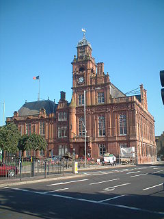
Great Yarmouth Town Hall, Hall Quay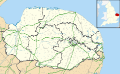
 Great Yarmouth
Great Yarmouth shown within NorfolkArea 26.54 km2 (10.25 sq mi) Population 47,288 (2010 True Knowledge census) - Density 1,782 /km2 (4,620 /sq mi) OS grid reference TG5207 District Great Yarmouth Shire county Norfolk Region East Country England Sovereign state United Kingdom Post town GREAT YARMOUTH Postcode district NR30 (north), NR31 (south) Dialling code +44 (0)1493 Police Norfolk Fire Norfolk Ambulance East of England EU Parliament East of England UK Parliament Great Yarmouth List of places: UK • England • Norfolk Great Yarmouth, often known to locals as Yarmouth, is a coastal town in Norfolk, England. It is at the mouth of the River Yare, 20 miles (32 km) east of Norwich.[1]
It has been a seaside resort since 1760, and is the gateway from the Norfolk Broads to the sea. For hundreds of years it was a major fishing port, dependent mainly on the herring fishery, but its fishing industry suffered a steep decline, and has now all but disappeared.[2] The discovery of oil in the North Sea in the 1960s led to a flourishing oil rig supply industry, and today it services offshore natural gas rigs. More recently, the development of renewable energy sources, especially offshore wind power, has created further opportunities for support services. A wind farm of 30 generators is within sight of the town on the Scroby Sands.
The town has a popular beach and two piers.
Contents
Geography and demography
The town itself is on a thin spit sandwiched between the North Sea and River Yare. It is home to the historic rows and the main tourist sector on the seafront. The area is linked to Gorleston, Cobholm and Southtown by Haven Bridge and to the A47, A149 and A12 by the Breydon Bridge.
The unparished urban area that makes up the town of Great Yarmouth has an area of 21.5 km2 (8.3 sq mi) and according to the Office for National Statistics in 2002 had a population of 47,288. It is the main town in the larger Borough of Great Yarmouth.[3] The ONS identify a Great Yarmouth Urban Area, which has a population of 66,788, including the sub-areas of Caister-on-Sea (8,756) and Great Yarmouth (58,032). The wider borough of Great Yarmouth has a population of around 92,500.
History
Great Yarmouth (Gernemwa, Yernemuth) lies near the site of the Roman fort camp of Gariannonum at the mouth of the River Yare. Its situation having attracted fishermen from the Cinque Ports, a permanent settlement was made, and the town numbered 70 burgesses before the Norman Conquest. Henry I placed it under the rule of a reeve.
 The 133 foot-tall Britannia Monument, built in 1817.
The charter of King John (1208), which gave his burgesses of Yarmouth general liberties according to the customs of Oxford, a gild merchant and weekly hustings, was amplified by several later charters asserting the rights of the borough against Little Yarmouth and Gorleston. A thirteenth century charter was granted by Henry III (1207–1272) to the town of Great Yarmouth. The town is bound to send to the sheriffs of Norwich every year one hundred herrings, baked in twenty four pasties, which the sheriffs are to deliver to the lord of the manor of East Carlton who is then to convey them to the King.[4]
In 1552 Elizabeth granted a charter of admiralty jurisdiction, confirmed and extended by James I. In 1668 Charles II incorporated Little Yarmouth in the borough by a charter which with one brief exception remained in force until 1703, when Anne replaced the two bailiffs by a mayor. In the early 18th Century Yarmouth, as a thriving herring port was vividly and admiringly described several times in Daniel Defoe's travel journals, in part as follows:[5]
Yarmouth is an antient town, much older than Norwich; and at present, tho' not standing on so much ground, yet better built; much more compleat; for number of inhabitants, not much inferior; and for wealth, trade, and advantage of its situation, infinitely superior to Norwich. It is plac'd on a peninsula between the River Yare and the sea; the two last lying parallel to one another, and the town in the middle: The river lies on the west-side of the town, and being grown very large and deep, by a conflux of all the rivers on this side the county, forms the haven; and the town facing to the west also, and open to the river, makes the finest key in England, if not in Europe, not inferior even to that of Marseilles itself. The ships ride here so close, and as it were, keeping up one another, with their head-fasts on shore, that for half a mile together, they go cross the stream with their bolsprits over the land, their bowes, or heads, touching the very wharf; so that one may walk from ship to ship as on a floating bridge, all along by the shore-side: The key reaching from the drawbridge almost to the south-gate, is so spacious and wide, that in some places 'tis near one hundred yards from the houses to the wharf. In this pleasant and agreeable range of houses are some very magnificent buildings, and among the rest, the custom-house and town-hall, and some merchants houses, which look like little palaces, rather than the dwelling-houses of private men. The greatest defect of this beautiful town, seems to be, that tho' it is very rich and encreasing in wealth and trade, and consequently in people, there is not room to enlarge the town by building; which would be certainly done much more than it is, but that the river on the land-side prescribes them, except at the north end without the gate....
A grammar school was founded in 1551, when the great hall of the old hospital, founded in the reign of Edward I by Thomas Fastolfe, was appropriated to its use. It was closed from 1757 to 1860, was re-established by the charity trustees, and settled in new buildings in 1872.
From 1808 to 1814 the Admiralty in London could communicate with its ships in the port of Great Yarmouth by a shutter telegraph chain.
The town was the site of a bridge disaster and drowning tragedy on 2 May 1845 when a suspension bridge crowded with children collapsed under the weight killing 79. They had gathered to watch a clown in a barrel being pulled by geese down the river. As he passed under the bridge the weight shifted, causing the chains on the south side to snap, tipping over the bridge deck.[6]
Great Yarmouth had an electric tramway system from 1902 to 1933.
During World War I Great Yarmouth suffered the first aerial bombardment in the UK, by Zeppelin L3 on 19 January 1915. That same year on 15 August, Ernest Martin Jehan became the first and only man to sink a steel submarine with a sail rigged Q-ship, this off the coast of Great Yarmouth. It was also bombarded by the German Navy on 24 April 1916.
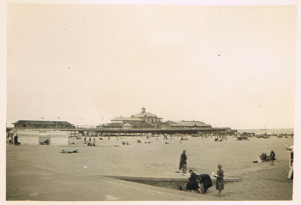
 Brittania Pier in 1930.
The town suffered Luftwaffe bombing during World War II as Great Yarmouth was the last place to drop bombs before German bombers returned home but much is left of the old town, including the original 2000m protective mediaeval wall, of which two-thirds has survived. Of the 18 towers, 11 are left. On the South Quay, there is a 17th century Merchant's House, as well as Tudor, Georgian and Victorian buildings. Behind South Quay, there is a maze of alleys and lanes known as "The Rows". Originally there were 145. Despite war damage, several have remained.
The northern section of the two-mile (3 km) A47 Great Yarmouth Western Bypass opened in March 1986, and the southern section in May 1985. It is now the A12.
More recently flooding has been a problem, the town flooding four times in 2006. In September 2006 the town suffered its worst flooding in years. Torrential rain caused drains to block as well as an Anglian Water pumping station to break down and this resulted in flash flooding around the town in which 90 properties were flooded up to 5 ft.[7]
The town was badly affected by the North Sea flood of 1953. On 9 November 2007 the town braced itself for more flooding as a result of a tidal surge and high tides but disaster was avoided and only a small area was under water.[8]
New Ferry Route
Initially the idea of the outer harbour was sold to the public as a ferry terminal with 150,000 trucks passing through yearly and 10,000 jobs created. Before the deal was signed for the construction of the Outer Harbour Superfast Ferries disappeared from the scene and in a recent press release Managing Director Eddie Freeman of Great Yarmouth Port Company Ltd was reported as saying that he had never promised a ro-ro terminal. This seems to be reinforced by Peter Hardy of Great Yarmouth Borough Council who in the same article was reported as saying people should not get too hung up about a ro-ro terminal.[citation needed]
Sights
 Panorama of Hall Quay seen from Southtown. This shows the Town Hall and Star Hotel. Historic South Quay continues to the right of the image.
The Tollhouse, with dungeons, dates from the late 13th century and is said to be the oldest civic building in Britain[citation needed]. It backs on to the central library.
The Market place is one of the largest in England, and has been operating since the 13th century. It is also home to the town's shopping sector and the famous Yarmouth chip stalls. The smaller area south of the market is used as a performance area for community events and for access to the town's shopping centre, Market Gates. In November 2008, a new section of Market Gates opened, including high street retailers such as Debenhams, New Look and Starbucks.
Great Yarmouth railway station, which serves the town, is the terminus of the Wherry Lines from Norwich. Before the Beeching Axe the town had a number of railway stations and a direct link to London down the east coast. The only remaining signs of these stations is the coach park where Beach Station once was and the A12 relief road which follows the route of the railway down into the embankment from Breydon Bridge.
 Britannia Pier
Yarmouth has two piers, Britannia Pier and Wellington Pier. The theatre building on the latter of the two was demolished in 2005 and is currently being rebuilt as a family entertainment centre. Britannia Pier is home to the Britannia Theatre which during the summer months features well known acts including; Jim Davidson, Basil Brush, Cannon and Ball, Chubby Brown, Chuckle Brothers and The Searchers. The theatre is one of a few end of the pier theatres left in England.
The Grade II listed Winter Gardens building sits next to the Wellington Pier. The cast iron framed glass structure was shipped by barge from Torquay in 1903. It is said this was done without the loss of a single pane of glass. Over the years, it has been used as ballroom, roller skating rink and beer garden. In the 1990s it was converted into a nightclub by comedian Jim Davidson. Today, The Winter Gardens are used as a family leisure venue, although its future is under threat owing to the cost of repairing the aging framework. During the winter of 2005 there were worries that building might collapse, and during high winds it was often closed.
Great Yarmouth's seafront, known as "The Golden Mile" attracts hundreds of thousands of visitors each year to its sandy beaches, Pleasure Beach, indoor attractions and amusement arcades. Great Yarmouth's Marine Parade has 12 Amusement Arcades located within 2 square miles (5.2 km2), including: Atlantis, The Flamingo, Circus Circus, The Golden Nugget, The Mint, Leisureland, The Majestic, The Silver Slipper, The Showboat, Magic City, Quicksilver and The Gold Rush, opened in 2007.
The South Denes area is home to the Grade I listed Norfolk Naval Pillar, known locally as Nelson's Monument or Nelson's Column. This tribute to Admiral Lord Horatio Nelson was completed in 1819, 24 years before the completion of Nelson's Column in London. The monument, designed by William Wilkins, shows Britannia standing atop a globe holding an olive branch in her right hand and a trident in her left.There is a popular assumption in the town that the statue of Britannia was supposed to face out to sea but now faces inland due to a mistake during construction, although it is thought she is meant to face Nelson's birthplace at Burnham Thorpe. The monument was originally planned to mark Nelson's victory at the Battle of the Nile, but fund-raising was not completed until after his death and it was instead dedicated to England's greatest Naval hero. It is currently surrounded by an industrial estate but plans are in place for the improvement of the area. The Norfolk Nelson Museum on South Quay houses the Ben Burgess collection of Nelson Memorabilia and is the only dedicated Nelson museum in Britain other than one in Monmouth. Its several galleries look at Nelson's life and personality as well as what life was like for the men who sailed under him.
 Small boat at the Time and Tide museum
 Central Beach close to the Jetty
Charles Dickens used Yarmouth as a key location in his novel David Copperfield. The author stayed at the Royal Hotel on the Marine parade while writing David Copperfield. Anna Sewell (1820–1878), the author of Black Beauty, was born in a 17th century house in Church Plain. The house is currently being used as a restaurant after being renovated in 2007.
The Time and Tide Museum on Blackfriars Road which is managed by Norfolk Museums Service was nominated in the UK Museums Awards in 2005. It was built as part of the regeneration of the south of the town in 2003. Its location in an old herring smokery harks back to the town's status as a major fishing port. Sections of the historic town wall are located outside the museum.
The Maritime Heritage East partnership, based at the award winning Time and Tide Museum aims to raise the profile of maritime heritage and museum collections.
Wildlife
The Yarmouth area is home to a number of rare and unusual species. The area between the piers is home to one of the largest roosts of Mediterranean Gulls in the UK. Breydon Water, just behind the town, is a major wader and waterfowl site, with winter roosts of over 100,000 birds. This, and the surrounding Halvergate Marshes are specially protected, and the majority of the area is now owned by conservation organisations, principally the RSPB.
The North Denes area of the beach is an SSSI due to its dune plants, and is home to numbers of Skylarks and Meadow Pipits. It also hosts one of the largest Little Tern colonies in the Uk each summer, as well as a small colony of Greyling butterflies. Other butterflies found here include Small Copper and Common Blue.
The near-by cemetery is renowned as a temporary roost for spring and autumn migrants, and sometimes sees spectacular 'falls'. Redstart and Pied Flycatcher are often seen here during migration. It has also been the site for the first records of a number of rare insects, blown in from the continent.
Grey Seal and Common Seal are frequently seen off-shore, as are sea-birds such as Gannet, Little Auk, Common Scoter, Razorbill and Guillemot.
Sports and leisure
The main local football club is Great Yarmouth Town, also known as the Bloaters, who play in the Eastern Counties League. Currently managed by Paul Tong, their ground is at Wellesley Recreation Ground (named after Sir Arthur Wellesley). They have a strong East Anglian rivalry with Gorleston. The club has enjoyed limited success in the past. Local football clubs are served by the Great Yarmouth and District League.
Yarmouth has a horse-racing track which features a chute allowing races of one mile (1.6 km) on the straight.
Speedway racing was staged in Great Yarmouth before and after the Second World War. The meetings were staged at the greyhound stadium in Caister Road. The post war team were known as the Yarmouth Bloaters (after the smoked fish). Banger and Stock car racing is also staged at this stadium.
The main Leisure Centre is the Marina Centre. Built in 1981 the centre has a large swimming pool, conference facilities and live entertainment including their famous Summer Pantomimes and Summer Variety Shows produced by local entertainers Hanton & Dean. The centre is run by the Great Yarmouth Sport and leisure Trust. The Trust was set up in April 2006 to run the building as a charitable non profit making organisation.
At the beginning of the 2008 summer season a worlds first Segway Grand Prix was opened at the Pleasure Beach gardens.
Pop Beach
In 2003 and 2004 T4 hosted their T4 on the Beach music festival in the town. It attracted around 20,000 people to the town but was moved to Weston-super-Mare in 2005.[9]
Transport
Rail
Great Yarmouth is connected to Norwich by the Wherry Lines from Great Yarmouth railway station, it is served by an hourly service provided by National Express East Anglia via Acle or, less frequently, via Reedham.[10] It is the only remaining station of the three once in the town.
The town was adversely affected by the Beeching Axe. There were previously four railway lines coming into the town; from the north the line came down the coast from Melton Constable into the terminus at Beach station. From the south-west came the line from London via Beccles and from the south the line from Lowestoft Central via Hopton and Gorleston; both of which terminated at South Town station.[11] The only existing terminal is Vauxhall station which is now simply referred to as 'Great Yarmouth station'. Whereas once the town had 17 stations within the borough limits it now only has one.
Bus
The bus station in Great Yarmouth is the major hub for local routes and is located under Market Gates Shopping Centre. The X1 route operated by First Eastern Counties provides a long-distance link between Peterborough and Lowestoft via Norwich and King's Lynn. Other local bus services link the suburban areas of Martham, Hemsby, Gorleston, Bradwell and Belton/ These are mostly operated by First Eastern Counties and services to towns further afield such as Beccles, Southwold, Acle and Diss are mostly operated by Anglian Bus.
 Haven Bridge; one of the two main links to the town in the upright position to allow boats to pass underneath.
Port and River
The River Yare cuts off Great Yarmouth from other areas of the borough such as Gorleston and Southtown and so the town's two bridges have become major transport links. Originally Haven Bridge had been the only link over the river but in the late 1980s Breydon Bridge was built to take the A12 over Breydon Water replacing the old railway bridge; the Breydon Viaduct.[12] both bridges can open to allow river traffic underneath which can result in traffic tailbacks. The phrase "the bridge was up" has become synonymous in the town with being late for appointments.
A ferry had been provided between the southerly tip of Great Yarmouth and Gorleston, it provided a way of getting between the factories on South Denes and the mostly residential areas of Gorleston without taking a long detour over the bridge. However; due to increased running costs and the decline of industrial activity in the town it was closed in the early 1990s.[13]
Since 2006, the restored pleasure steamer the Southern Belle has provided regular river excursions from the town's Haven Bridge. Built in 1925 for the Earl of Mount Edgcumbe. Today, she is owned by the Great Yarmouth and Gorleston Steam Packet Company Limited.[14]
Construction work on the Outer Harbour began in June 2007 and was completed by 2009, it is a deep-water harbour on the North Sea. Originally there were plans for a ro-ro ferry link with IJmuiden which has failed to materialise, similarly despite the installation of two large cranes in 2009 plans for a container terminal have also been scrapped.[15]
Lifeboat station
Main article: Great Yarmouth and Gorleston lifeboat stationThere has been a lifeboat in Great Yarmouth since at least 1802. The early boats were privately operated until 1857 when the RNLI took over.[16] The lifeboat station is located on Riverside Road (52°34′32″N 1°43′55″E / 52.5754192°N 1.7320392°E) from where are operated the Trent class lifeboat Samarbeta and the B class (inshore) lifeboat Seahorse IV.[17]
 The view from the top of the Atlantis Tower showing the Golden Mile and, in the distance, the Outer Harbour
Road
The A12 terminates in the town as do the A143 and the A47 roads. The relief road was built along the path of the old railway to carry the A12 onwards to Lowestoft and London. Congestion is a major problem in the town and roundabouts, junctions and bridges can become gridlocked at rush hour.
Proposed third river crossing
Plans have been put forward for the construction of a third river crossing in Great Yarmouth which would link northern Gorleston with the South Denes and the Outer Harbour avoiding the congested town centre. A public consultation took place in mid-2009 over the four possible proposals but as of late-2010 the plans are stalled by a lack of funding and the closure of the container terminal.[18]
Air
The North Denes Heliport is located to the north of the town and currently operated by CHC Helicopter but it is planned to close in 2011 with operations being moved to Norwich International Airport.[19]
First Responders
There is an East of England Ambulance Service First Responder group setup to cover the Great Yarmouth area. A First Responder scheme is made up of a group of volunteers who within the community in which they live or work, have been trained to attend emergency 999 calls by the NHS Ambulance Service.[20] Responders are members of the community who are trained to use an Automated External Defibrillator, Oxygen and other lifesaving equipment to assist ambulance crews. Community First Responders are not a substitute for the Ambulance Service. But, as they are based within Great Yarmouth, they are able to attend the scene of an emergency call in a very short time; often within the first few minutes and, in the majority of incidents, they will be first on scene. Community First Responders are able to administer vital, life saving first aid treatment before the arrival of an Ambulance crew. Their early intervention further increases the patient's chance of survival or may just provide the simple reassurance that the ambulance crew are on their way. Great Yarmouth First Responders themselves are not paid, being a First Responder is completely voluntary. However the Community First Responder schemes are not funded by the East of England Ambulance Service and rely solely on help from the publics donations.
Notable residents
- Vice-Admiral Horatio Nelson (1758–1805)
- James Beeching (1788–1858) was a shipbuilder in the town, and his firm continued after his death well into the 20th century.
- Oscar winning cinematographer Jack Cardiff (1914–2009)
- English physician and writer Dr Thomas Girdlestone (1758–1822)
- Captain George William Manby (1765–1854), inventor of marine lifesaving equipment
- William Hovell (1786–1875), explorer of Australia was born in Great Yarmouth.
- Sir James Paget (1814–99), Victorian Surgeon who had the James Paget Hospital named in his honour.
- Anna Sewell (1820–78), author of Black Beauty
- Leading English Independent Minister William Bridge (c1600-70)
- Alternative rock band Catherine Wheel were from Great Yarmouth
- Rebecca Nurse ( 1621-1692 ) celebrated victim of the Salem Witch Trials, was born in Great Yarmouth.
Twinning
Great Yarmouth is twinned with:
 Rambouillet, France
See also
- Great Yarmouth Pleasure Beach
- St Nicholas Church, Great Yarmouth
- Lydia Eva the last surviving steam drifter of the Great Yarmouth herring fishing fleet
References
- ^ Ordnance Survey (2005). OS Explorer Map OL40 - The Broads. ISBN 0-319-23769-9.
- ^ "Town's last fishing boat fights tide and time". The Daily Telegraph. 14 January 2008. http://www.telegraph.co.uk/news/uknews/1575561/Towns-last-fishing-boat-fights-tide-and-time.html.
- ^ Office for National Statistics & Norfolk County Council (2001). Census population and household counts for unparished urban areas and all parishes. Retrieved 2 December 2005.
- ^ Nuttall, P Austin (1840). A classical and archæological dictionary of the manners, customs, laws, institutions, arts, etc. of the celebrated nations of antiquity, and of the middle ages. London. p. 555. http://www.google.co.uk/books?id=V-gDAAAAQAAJ&pg=PA555&dq=Yarmouth+pasties&as_brr=1.
- ^ Daniel Defoe, A tour thro' the whole island of Great Britain, divided into circuits or journies (1724), Letter 1, Pt 3. Defoe's several descriptions may be accessed on the Vision of Britain website
- ^ "The Fall of Yarmouth Road". AngliaCampus. http://www.jeron.je/anglia/learn/sec/history/yarmouth/page03.htm. Retrieved 11 October 2009.
- ^ "England | Norfolk | Homes under water in flash floods". BBC News. 25 September 2006. http://news.bbc.co.uk/1/hi/england/norfolk/5378080.stm. Retrieved 29 January 2010.
- ^ Turner, Andrew (9 November 2007). "England | Norfolk | Residents ride out storm surge". BBC News. http://news.bbc.co.uk/1/hi/england/norfolk/7086419.stm. Retrieved 29 January 2010.
- ^ Event Info Pop Beach Website; Retrieved 20 November 2010]
- ^ National Express East Anglia Timetables. Retrieved 20 November 2010.
- ^ New Adlestrop Railway Atlas Retrieved 20 November 2010
- ^ Building the Breydon Bridge, June 1985 Our Great Yarmouth, Retrieved 20 November 2010
- ^ Great Yarmouth Ferry Crossings Our Great Yarmouth; Retrieved 20 November 2010
- ^ The Southern Belle. Retrieved 29 October 2009.
- ^ Stephen Pullinger (10 November 2010). "Great Yarmouth outer harbour’s £7m cranes to go". Eastern Daily Press. http://www.edp24.co.uk/business/great_yarmouth_outer_harbour_s_7m_cranes_to_go_1_722070. Retrieved 20 November 2010.
- ^ RNLI history of Great Yarmouth & Gorleston lifeboat station
- ^ "Great Yarmouth and Gorleston Fleet". RNLI. http://www.rnli.org.uk/rnli_near_you/east/stations/GreatYarmouthandGorlestonNorfolk/fleet. Retrieved 29 January 2010.
- ^ "Cash concerns over third crossing" East Coast Live; Retrieved 20 November 2010
- ^ "Town’s heliport to close next year" East Coast Live; Retrieved 20 November 2010]
- ^ "Great Yarmouth First Responders". Great Yarmouth First Responders. http://www.gyresponders.org. Retrieved 22 June 2010.
Further reading
- Ferry, Kathryn (2009) "'The maker of modern Yarmouth': J. W. Cockrill", in: Ferry, Kathryn, ed. Powerhouses of Provincial Architecture, 1837-1914. London: Victorian Society; pp. 45-58
External links
Boroughs or districts Major settlements Acle • Attleborough • Aylsham • Cromer • Dereham • Diss • Downham Market • Fakenham • Gorleston-on-Sea • Great Yarmouth • Hingham • Holt • Hunstanton • King's Lynn • Loddon • North Walsham • Norwich • Redenhall with Harleston • Reepham • Sheringham • Stalham • Swaffham • Thetford • Thorpe St Andrew • Watton • Wells-next-the-Sea • Wymondham
See also: List of civil parishes in NorfolkTopics  (RNLI) and Independent Lifeboat stations in Norfolk
Caister Beach Company lifeboatsUnnamed 1st • Unnamed 2ndNo. 1 station lifeboatsCharles Burton • James Haylett • Charles Bonney GeorgeLifeboat disasterCromer Beach station
lifeboatsUnnamed 1st • Unnamed 2nd • Unnamed 3rd (RNLI) • Henry Blogg · Henry Thomas DaviesNotable rescuesBarque Alf • SS Cantabria · SS English Trader · SS Gallois • SS Georgia · SS Meriones • SS Monte Nevoso • Stuart Hill (sailor) · SS Mount Ida · HMS Vortigern (D37)Great Yarmouth &
GorlestonLifeboatsWilliam Fleming ·Notable rescuesSS Hopelyn •Lifeboat disastersGorleston lifeboat disaster (1866) · Gorleston lifeboat disaster (1867) · Gorleston lifeboat disaster (1881) · Gorleston lifeboat disaster (1888)Happisburgh RNLI LifeboatsSpirit of Berkhamsted • Friendly Forester IIHunstanton RNLI LifeboatsDJS Haverhill • Hunstanton Flyer (Civil Service No.45)Mundesley Private LifeboatsFootprintsSheringham Private lifeboatsRNLI
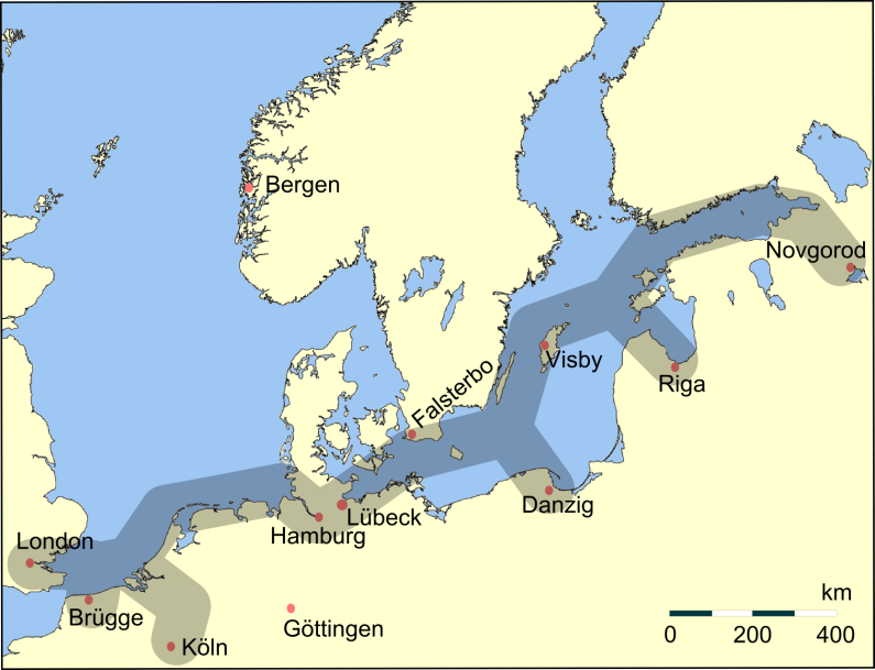
lifeboatsDuncan • William Bennett (ON 11) • J C Madge (ON 536) • ILB (D 204) • Lloyds II (ON 986) • ILB (B 536) • Manchester Unity of Oddfellows (B 702)Notable rescuesWells-next-the-Sea Lifeboat disasterRelated topics Members of the Hanseatic League by Quarter Chief cities are highlighted; Free Imperial Cities of the Holy Roman Empire are shown in italics.Wendish Quarter Anklam · Demmin · Greifswald · Hamburg · Kolberg (Kołobrzeg) · Lüneburg · Rostock · Rügenwalde (Darłowo) · Stettin (Szczecin) · Stolp (Słupsk) · Stockholm · Stralsund · Visby · Wismar
Saxon Quarter Baltic Quarter Westphalian
QuarterPrincipal Kontore Subsidiary Kontore Other cities Categories:- Great Yarmouth
- Towns in Norfolk
- Populated coastal places in Norfolk
- Seaside resorts in England
- Tourism in the United Kingdom
- Ports and harbours of Norfolk
- Port cities and towns of the North Sea
- Marinas in the United Kingdom
- Staple ports
- Trading posts of the Hanseatic League


Wikimedia Foundation. 2010.