- Chattahoochee County, Georgia
-
Chattahoochee County, Georgia 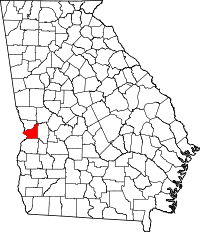
Location in the state of Georgia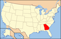
Georgia's location in the U.S.Founded 1854 Seat Cusseta Largest city Cusseta Area
- Total
- Land
- Water
251.17 sq mi (651 km²)
248.77 sq mi (644 km²)
2.40 sq mi (6 km²), 0.96%PopulationEst.
- (2006)
- Density
14,041
60/sq mi (23/km²)Time zone Eastern: UTC-5/-4 Chattahoochee County is a county located in the U.S. state of Georgia. It was created on February 13, 1854. The 2000 Census reported a population of 14,882. The 2009 Census Estimate shows a population of 14,402.[1] It is part of the Columbus, Georgia-Alabama Metropolitan Statistical Area. The county seat is Cusseta.[2]
Contents
History
The Georgia General Assembly created Chattahoochee County on February 13, 1854, from portions of Muscogee and Marion counties. It is named for the Chattahoochee River that forms its western boundary. The county seat was named Cusseta to commemorate the Creek Indian town that used to exist nearby. In 2004-2005, the US Census Bureau reported a 6.2% population decline, making top on the national list of counties with shrinking poulation.
The original courthouse, built in 1854 by slaves, is preserved at the tourist attraction of Westville, near Lumpkin, Georgia.
Geography
According to the 2000 census, the county has a total area of 251.17 square miles (650.5 km2), of which 248.77 square miles (644.3 km2) (or 99.04%) is land and 2.40 square miles (6.2 km2) (or 0.96%) is water.[3] is water.
Major highways
 U.S. Route 27
 U.S. Route 280
 State Route 1
 State Route 26
 State Route 520
Adjacent counties
- Muscogee County (north)
- Talbot County (northeast)
- Marion County (east)
- Stewart County (south)
- Russell County, Alabama (west)
Demographics
As of the census[4] of 2000, there were 14,882 people, 2,932 households, and 2,624 families residing in the county. The population density was 60 people per square mile (23/km²). There were 3,316 housing units at an average density of 13 per square mile (5/km²). The racial makeup of the county was 58.08% White, 29.92% Black or African American, 0.80% Native American, 1.80% Asian, 0.45% Pacific Islander, 5.18% from other races, and 3.77% from two or more races. 10.42% of the population were Hispanic or Latino of any race.
There were 2,932 households out of which 64.80% had children under the age of 18 living with them, 76.30% were married couples living together, 10.10% had a female householder with no husband present, and 10.50% were non-families. 8.90% of all households were made up of individuals and 2.30% had someone living alone who was 65 years of age or older. The average household size was 3.41 and the average family size was 3.64.
In the county the population was spread out with 28.40% under the age of 18, 27.90% from 18 to 24, 36.40% from 25 to 44, 5.50% from 45 to 64, and 1.80% who were 65 years of age or older. The median age was 23 years. For every 100 females there were 171.70 males. For every 100 females age 18 and over, there were 217.60 males.
The median income for a household in the county was $37,106, and the median income for a family was $38,313. Males had a median income of $21,975 versus $20,648 for females. The per capita income for the county was $14,049. About 8.90% of families and 10.60% of the population were below the poverty line, including 11.50% of those under age 18 and 18.60% of those age 65 or over.
Education
Main article: Cusseta, Georgia#EducationCities and towns
See also
References
- ^ 2009 Census Estimate
- ^ "Find a County". National Association of Counties. http://www.naco.org/Counties/Pages/FindACounty.aspx. Retrieved 2011-06-07.
- ^ "Census 2000 U.S. Gazetteer Files: Counties". United States Census. http://www.census.gov/tiger/tms/gazetteer/county2k.txt. Retrieved 2011-02-13.
- ^ "American FactFinder". United States Census Bureau. http://factfinder.census.gov. Retrieved 2008-01-31.
External links
- Columbus Enquirer Archive Digital Library of Georgia

Muscogee County Talbot County Russell County, Alabama 
Marion County  Chattahoochee County, Georgia

Stewart County Greater Columbus, Georgia Central cities/Largest cities 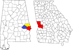 Location of the Columbus, Georgia-Auburn, Alabama CSA and its counties:
 Columbus, Georgia Metropolitan Statistical AreaAuburn, Alabama Metropolitan Statistical AreaTuskegee, Alabama Micropolitan Statistical Area
Cities in Georgia Bibb City · Buena Vista · Cataula · Columbus · Cusseta · Custer Terrace · Fort Benning South · Fortson · Hamilton · Hopewell · Juniper · Midland · Mountain Hill · Mulberry Grove · Pine Mountain · Rehobeth · Ridgeway · Shiloh · Upatoi · Waverly Hall · West Point · WhitesvilleCities in Alabama Beauregard · Bee Hive · Beulah · Creek Stand · Fort Mitchell · Franklin · Glenville · Gold Hill · Holy Trinity · Hurtsboro · Ladonia · Loachapoka · Marvyn · Notasulga · Opelika · Phenix City · Roxana · Salem · Seale · Shorter · Smiths Station · The Bottle · Tuskegee · WaverlyCounties in Georgia Counties in Alabama Categories:- Georgia (U.S. state) counties
- Chattahoochee County, Georgia
- 1854 establishments in the United States
- Columbus, Georgia metropolitan area


Wikimedia Foundation. 2010.