- Dooly County, Georgia
-
Dooly County, Georgia 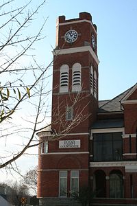 Dooly County courthouse in Vienna, Georgia
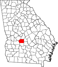
Location in the state of Georgia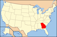
Georgia's location in the U.S.Founded May 15, 1821 Seat Vienna Largest city Vienna Area
- Total
- Land
- Water
397.07 sq mi (1,028 km²)
392.88 sq mi (1,018 km²)
4.19 sq mi (11 km²), 1.06%PopulationEst.
- (2005)
- Density
11,749
29/sq mi (11/km²)Time zone Eastern: UTC-5/-4 Dooly County is a county located in the U.S. state of Georgia. As of 2000, the population was 11,525. The 2007 Census Estimate shows a population of 11,592.[1] The county seat is Vienna.[2]
Dooly County was created by an act of the Georgia General Assembly on May 15, 1821. It was one of the original landlot counties created from land ceded from the Creek Nation. The County Seat is Vienna, Georgia.
The entire county of Crisp and parts of Macon, Pulaski, Turner, Wilcox and Worth counties were formed from Dooly's original borders.
The County is named for Colonel John Dooly, a Georgia American revolutionary war fighter who helped prosecute Tories in 1779 and was murdered by them the following year.
Notable Dooly County residents include former governor George Busbee; former U.S. senator Walter F. George; the late Jody Powell, press secretary and aide to Jimmy Carter during his governorship and U.S. presidency; and Roger Kingdom, an Olympic gold medalist in track and field.
Recently, Dooly County has enjoyed some measure of fame due to the success of NASCAR driver David Ragan, who originally hails from Unadilla. Ragan presently drives the #6 UPS Ford car in the Sprint Cup NASCAR circuit for Jack Roush's Roush-Fenway Racing team.
Contents
Geography
According to the 2000 census, the county has a total area of 397.07 square miles (1,028.4 km2), of which 392.88 square miles (1,017.6 km2) (or 98.94%) is land and 4.19 square miles (10.9 km2) (or 1.06%) is water.[3]
Major highways
 Interstate 75
 U.S. Route 41
 State Route 7
 State Route 27
 State Route 90
 State Route 215
 State Route 230
 State Route 257
 State Route 329
Adjacent counties
- Houston County, Georgia - northeast
- Pulaski County, Georgia - east
- Wilcox County, Georgia - southeast
- Crisp County, Georgia - south
- Sumter County, Georgia - west
- Macon County, Georgia - northwest
Economy
The Big Pig Jig, Georgia's official State Barbecue Cooking Championship, is held annually in Fall in Dooly county and attracts a national audience. The county is also notable for cotton and peanut production.
Demographics
As of the census[4] of 2000, there were 11,525 people, 3,909 households, and 2,767 families residing in the county. The population density was 29 people per square mile (11/km²). There were 4,499 housing units at an average density of 12 per square mile (4/km²). The racial makeup of the county was 45.97% White, 49.54% Black or African American, 0.16% Native American, 0.43% Asian, 0.11% Pacific Islander, 2.88% from other races, and 0.91% from two or more races. 4.66% of the population were Hispanic or Latino of any race.
There were 3,909 households out of which 33.60% had children under the age of 18 living with them, 45.10% were married couples living together, 20.50% had a female householder with no husband present, and 29.20% were non-families. 25.90% of all households were made up of individuals and 11.40% had someone living alone who was 65 years of age or older. The average household size was 2.62 and the average family size was 3.14.
In the county the population was spread out with 25.60% under the age of 18, 10.30% from 18 to 24, 29.80% from 25 to 44, 22.50% from 45 to 64, and 11.80% who were 65 years of age or older. The median age was 35 years. For every 100 females there were 109.50 males. For every 100 females age 18 and over, there were 111.70 males.
The median income for a household in the county was $27,980, and the median income for a family was $35,337. Males had a median income of $26,670 versus $19,076 for females. The per capita income for the county was $13,628. About 18.00% of families and 22.10% of the population were below the poverty line, including 29.50% of those under age 18 and 21.20% of those age 65 or over.
Cities and towns
Education
Main article: Vienna, Georgia#EducationPrivate Schools
- Fullington Academy http://www.fullingtonacademy.com/
- Faith Christian School and Church
See also
References
- ^ [1]
- ^ "Find a County". National Association of Counties. http://www.naco.org/Counties/Pages/FindACounty.aspx. Retrieved 2011-06-07.
- ^ "Census 2000 U.S. Gazetteer Files: Counties". United States Census. http://www.census.gov/tiger/tms/gazetteer/county2k.txt. Retrieved 2011-02-13.
- ^ "American FactFinder". United States Census Bureau. http://factfinder.census.gov. Retrieved 2008-01-31.

Macon County Houston County Sumter County 
Pulaski County  Dooly County, Georgia

Crisp County Wilcox County Municipalities and communities of Dooly County, Georgia Cities 
Towns Macon-Warner Robins-Fort Valley Combined Statistical Area Principal cities 
Municipalities Allentown • Byron • Centerville • Culloden • Danville • Forsyth • Gray • Jeffersonville • Perry • RobertaOther
communitiesAvondale • Bolingbroke • Bonaire • Clinchfield • Dunbar • Elberta • Elko • Franklinton • Haddock • Juliette • Kathleen • Knoxville • Lizella • Musella • Robins AFB • Sofkee • Smarr • WaldenCounties CSA
componentsMacon Metropolitan Statistical Area • Warner Robins Metropolitan Statistical Area • Fort Valley Micropolitan Statistical AreaCategories:- Georgia (U.S. state) counties
- Dooly County, Georgia
- 1821 establishments in the United States
- Populated places established in 1821


Wikimedia Foundation. 2010.