- Tift County, Georgia
-
Tift County, Georgia 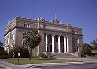 Tift County Courthouse, (Built 1912), Tifton, Georgia
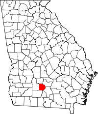
Location in the state of Georgia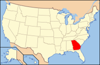
Georgia's location in the U.S.Founded August 17, 1905 Named for Nelson Tift Seat Tifton Largest city Tifton Area
- Total
- Land
- Water
268.86 sq mi (696 km²)
265.05 sq mi (686 km²)
3.81 sq mi (10 km²), 1.42%PopulationEst.
- (2010)
- Density
40,118
56/sq mi (145/km²)Time zone Eastern: UTC-5/-4 Website www.tiftcounty.org Tift County is a county located in the U.S. state of Georgia. As of 2000, the population was 38,407. The 2007 Census Estimate shows a population of 41,610.[1] The county seat is Tifton.[2]
Contents
History
The County was created on August 17, 1905, and is named for Nelson Tift, founder of the Georgia city of Albany and a United States Representative.[3]
Geography
According to the 2000 census, the county has a total area of 268.86 square miles (696.3 km2), of which 265.05 square miles (686.5 km2) (or 98.58%) is land and 3.81 square miles (9.9 km2) (or 1.42%) is water.[4]
Major highways
 Interstate 75
 U.S. Highway 41
 U.S. Highway 82
 U.S. Highway 319
 Georgia State Route 7
 Georgia State Route 125
Adjacent counties
- Irwin County (northeast)
- Berrien County (southeast)
- Cook County (south)
- Colquitt County (southwest)
- Worth County (west)
- Turner County (north-northwest)
Demographics
As of the census[5] of 2000, there were 38,407 people, 13,919 households, and 10,105 families residing in the county. The population density was 145 people per square mile (56/km²). There were 15,411 housing units at an average density of 58 per square mile (22/km²). The racial makeup of the county was 65.31% White, 28.02% Black or African American, 0.20% Native American, 0.98% Asian, 0.02% Pacific Islander, 4.59% from other races, and 0.88% from two or more races. 7.67% of the population were Hispanic or Latino of any race.
There were 13,919 households out of which 35.40% had children under the age of 18 living with them, 51.40% were married couples living together, 16.90% had a female householder with no husband present, and 27.40% were non-families. 23.30% of all households were made up of individuals and 9.00% had someone living alone who was 65 years of age or older. The average household size was 2.65 and the average family size was 3.10.
In the county the population was spread out with 27.20% under the age of 18, 11.60% from 18 to 24, 28.40% from 25 to 44, 21.10% from 45 to 64, and 11.70% who were 65 years of age or older. The median age was 33 years. For every 100 females there were 94.50 males. For every 100 females age 18 and over, there were 91.50 males.
The median income for a household in the county was $32,616, and the median income for a family was $39,083. Males had a median income of $27,874 versus $20,997 for females. The per capita income for the county was $16,833. About 15.50% of families and 19.90% of the population were below the poverty line, including 28.00% of those under age 18 and 14.60% of those age 65 or over.
Cities and towns
Census Designated Places (CDP)
See also
References
- ^ [1]
- ^ "Find a County". National Association of Counties. http://www.naco.org/Counties/Pages/FindACounty.aspx. Retrieved 2011-06-07.
- ^ "Biography at the Biographical Directory of the United States Congress". http://bioguide.congress.gov/scripts/biodisplay.pl?index=T000269. Retrieved 2007-03-06.
- ^ "Census 2000 U.S. Gazetteer Files: Counties". United States Census. http://www.census.gov/tiger/tms/gazetteer/county2k.txt. Retrieved 2011-02-13.
- ^ "American FactFinder". United States Census Bureau. http://factfinder.census.gov. Retrieved 2008-01-31.
External links

Turner County Irwin County Worth County 
 Tift County, Georgia

Colquitt County Cook County Berrien County Municipalities and communities of Tift County, Georgia Cities 
CDPs Footnotes ‡This populated place also has portions in an adjacent county or counties
Categories:- Georgia (U.S. state) counties
- Tift County, Georgia
- States and territories established in 1905


Wikimedia Foundation. 2010.