- Indo-Gangetic Plain
-
 Schematic map of the Indo-Gangetic Plain
 Clusters of yellow lights on the Indo-Gangetic Plain reveal numerous cities large and small in this astronaut photograph of northern India and northern Pakistan.
The northern Plains also known as the Indo - Gangetic Plain and The North Indian River Plain is a large and fertile plain encompassing most of northern and eastern India, the most populous parts of Pakistan, parts of southern Nepal and virtually all of Bangladesh. The region is named after the Indus and the Ganges, the twin river systems that drain it.
The plain's population density is very high due to the fertile soil for farming.
The plains support one of the most populous areas on Earth, being home to nearly 1 billion people (or around 1/7 of the world's population) on 700,000 km² (270,000 mile²). Among the largest cities of the Indo-Gangetic plain are Ludhiana, Amritsar, Chandigarh, Delhi, Jaipur, Kanpur, Lucknow, Allahabad, Varanasi, Patna, Kolkata, Guwahati, Dhaka, Lahore, Faisalabad, Rawalpindi, Islamabad, Multan, Hyderabad and Karachi. In this region, it is hard to define where one megalopolis begins and one ends.
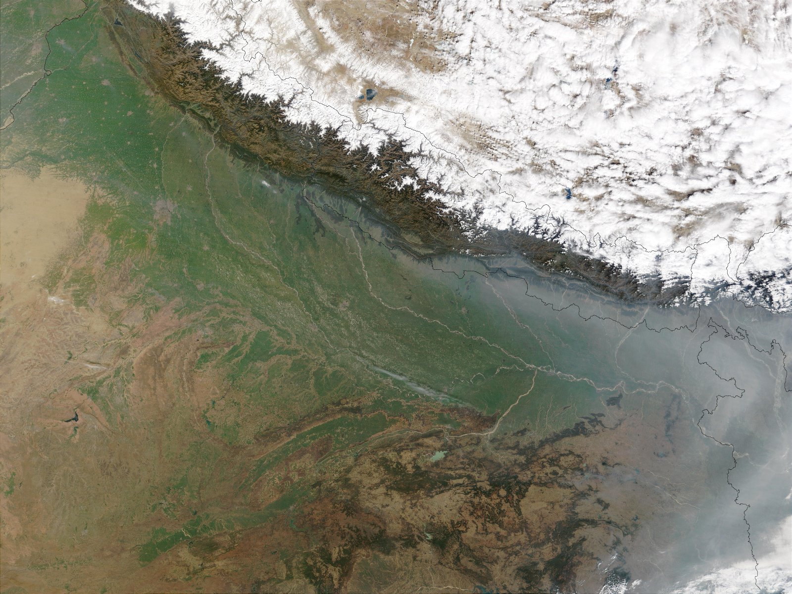
The Indo-Gangetic plain is bound on the north by the abruptly rising Himalayas, which feed its numerous rivers and are the source of the fertile alluvium deposited across the region by the two river systems. The southern edge of the plain is marked by the Vindhya- and Satpura Range, and the Chota Nagpur Plateau. On the west rises the Iranian Plateau.
Contents
Divisions
 A part of the Indo-Gangetic Plain
Some geographers subdivide the Indo-Gangetic Plain into several parts: the Indus Valley, the Punjab Plain, the Haryana Plains, and the middle and lower Ganges. These regional distinctions are based primarily on the availability of water.
By another definition, the Indo-Gangetic Plain is divided into two drainage basins by the Delhi Ridge; the western part consists of the Punjab Plain and the Haryana Plain, and the eastern part consists of the Ganges–Bramaputra drainage systems. This divide is only 300 metres above sea level, causing the perception that the Indo-Gangetic Plain appears to be continuous between the two drainage basins.
Both the Punjab and Haryana plains are irrigated with water from the Ravi, Beas, and Sutlej rivers. The irrigation projects in progress on these rivers have led to a decrease in the flow of water, which reaches the lower drainage areas in the state of Punjab in India and the Indus Valley in Pakistan. The benefits that the increased irrigation has brought to Haryana farmers are controversial, due to the effects that irrigation has had on agricultural life in the Punjab areas of both India and Pakistan.
The middle Ganges extends from the Yamuna River in the west to the state of West Bengal in the east. The lower Ganges and the Assam Valley are more verdant than the middle Ganges.
The lower Ganges is centered in West Bengal, from which it flows into India After joining the Yamuna, both rivers form the Ganges Delta.
The Brahmaputra rises in Tibet as the Yarlung Zangbo River and flows through Arunachal Pradesh and Assam, before crossing into Bangladesh.
Extent
As a large plain, the exact extent can vary from source to source. Roughly, the Indo-Gangetic Plain stretches across:
- Kashmir in the north;
- the Punjab region of Pakistan and the Aravalli Range;
- Sindh in the west;
- the Himalayan foothills of Assam and Bangladesh in the east; and
- the Vindhya- and Satpura Range, and the Chota Nagpur Plateau in the south.
- goes to northern portion of Gujarat
The fertile Terai region is the Nepalese extension of the Plain. The rivers encompassed are the Beas, the Chambal, the Chenab, the Ganges, the Gomti, the Indus, the Ravi, the Sutlej and the Yamuna. The soil is rich in silt, making the plain one of the most intensely farmed areas of the world. Even rural areas here are densely populated.
Geography
The Indo-Gangetic plains, also known as the "Great Plains," are large floodplains of the Indus and the Ganges–Brahmaputra river systems. They run parallel to the Himalaya mountains, from Jammu and Kashmir in the west to Assam in the east and draining most of northern and eastern India. The plains encompass an area of 700,000 km² (270,000 mile²) and vary in width through their length by several hundred kilometres. The major rivers of this system are the Ganges and the Indus along with their tributaries; Beas, Yamuna, Gomti, Ravi, Chambal, Sutlej and Chenab.
Extent of the Indo-Gangetic plain across South Asia.The great plains are sometimes classified into four divisions:
- The Bhabar belt — is adjacent to the foothills of the Himalayas and consists of boulders and pebbles which have been carried down by the river streams. As the porosity of this belt is very high, the streams flow underground. The bhabar is generally narrow about 7–15 km wide.
- The Terai belt — lies next to the Bhabar region and is composed of newer alluvium. The underground streams reappear in this region. The region is excessively moist and thickly forested. It also receives heavy rainfall throughout the year and is populated with a variety of wildlife.
- The Bangar belt — consists of older alluvium and forms the alluvial terrace of the flood plains. In the Gangetic plains, it has a low upland covered by laterite deposits.
- The Khadar belt — lies in lowland areas after the Bangar belt. It is made up of fresh newer alluvium which is deposited by the rivers flowing down the plain.
The Indo-Gangetic belt is the world's most extensive expanse of uninterrupted alluvium formed by the deposition of silt by the numerous rivers. The plains are flat and mostly treeless, making it conducive for irrigation through canals. The area is also rich in ground water sources.
The plains are the world's most intensely farmed areas. The main crops grown are rice and wheat, which are grown in rotation. Others include maize, sugarcane and cotton. The Indo-Gangetic plains rank among the world's most densely populated areas.
Fauna
Until recent history, the open grasslands of the Indo-Ganetic Plain was inhabited by several large species of animal. The open plains were home to large numbers of herbivores which included three species of rhinoceros (Indian rhinoceros, Javan rhinoceros, Sumatran rhinoceros). The open grasslands were in many ways similar to the landscape of modern Africa. Gazelle, buffalo, rhinos, elephants, lions, and hippo roamed the grasslands, the same way as they do in Africa today. Large herds of elephants, gazelles, antelopes and horses lived alongside several species of wild cattle including the now-extinct Auroch. In the forested areas there were several species of wild pig, deer and muntjac. In the wetter regions close to the Ganges there would have been large herds of Water Buffalo grazing on the riverbanks along with extinct species of hippopotamus.
So many large animals would have supported a large population of predators as well. Wolf, Dhole, Striped Hyena, Indian cheetah and Asiatic Lion would have hunted large game on the open plains, while tigers and leopards would stalk prey in the surrounding woods. In the Ganges there were large concentrations of gharial, mugger crocodile and river dolphin controlling fish stocks and the occasional migrating herd crossing the river.
Agriculture
Farming on the Indo-Gangetic Plain primarily consists of rice and wheat grown in rotation. Other crops include maize, sugarcane, and cotton.
The main source of rainfall is the southwest monsoon which is normally sufficient for general agriculture. The many rivers flowing out of the Himalayas provide water for major irrigation works.
Stressed water supplies
Due to a rapidly growing population (as well as other factors), this area is considered at high risk for water shortages in the future. This area constitutes the land between the river Brahmaputra and Aravli mountain ranges, the famous river Ganges,Yamuna,Ghaggra,Chambal and Brahmaputra flow through the area.
History
The region is known for the Indus Valley Civilization, centered in Pakistan, which was responsible for the birth of ancient South Asian culture. The flat and fertile terrain has facilitated the repeated rise and expansion of various empires, including the Gupta empire, Kanauj, Magadha, the Maurya Empire, the Mughal Empire and the Sultanate of Delhi – all of which had their demographic and political centers in the Indo-Gangetic plain. During the Vedic and Epic eras of Indian history, this region was referred to as "Aryavarta" (Land of the Aryans) which was bordered on the west by the Indus river and on the south by the Vindhya Mountain range. During the Islamic period, the Turkish, Afghan and Iranian rulers referred to this region as "Hindustan" (Land of the Hindus), deriving from the Persian term for the Indus River. This term was later used to refer to the whole of India but even into the modern era, the dialect of Hindi-Urdu spoken in this region is called Hindustani, a term which is also used for the local music and culture.[1][2]
Both British and independent India also had their demographic and political centers here (first in Calcutta and then Delhi).
Languages
The language of the Indo-Gangetic plain was previously Indo-Aryan. There is in addition a great variety of regional languages, which in several cases form a dialect chain with one another[citation needed].
Cities
Among the largest cities of the Indo-Gangetic plain are Ahmedabad, Ludhiana, Amritsar, Chandigarh, Delhi, Jaipur, Kanpur, Lucknow, Allahabad, Varanasi, Patna and Kolkata in India, Dhaka in Bangladesh, Lahore, Faisalabad, Rawalpindi-Islamabad, Multan, Hyderabad and Karachi in Pakistan. In this region, it is hard to define where one megalopolis begins and one ends.
Administrative divisions
Because it is not fully possible to define the boundaries of the Indo-Gangetic Plain, it is also difficult to give an exact list of which administrative areas are part on the plain.
The areas that are completely part or more than half part of the plains are:
- Bangladesh (almost the whole country)
- India
- Nepal
- the Madhesh
- Pakistan
Small parts of the following administrative areas are or are not part of the plain:
See also
References
- ^ "India". CIA – The World Factbook. https://www.cia.gov/library/publications/the-world-factbook/geos/in.html. Retrieved 2007-12-14.
- ^ "Hindustani Classical Music". Indian Melody. http://www.indianmelody.com/hindustani.htm. Retrieved 2007-12-14.
External links
Topics related to Geography of India Climate Geology Geology · Geological historyLandforms Beaches · Desert · Extreme points · Glaciers · Islands · Lakes · Mountains · Rivers · Valleys · Volcanoes · Waterfalls
Plains (Gangetic Plains · Eastern Coastal · Western Coastal)Regions Subdivisions Environment Biosphere Reserves · Ecoregions · Fauna · Flora · National Parks · Protected Areas · Sanctuaries · WildlifeMountains and Plateaus Himalayas · Western Ghats · Eastern Ghats · Aravalli Range · The Nilgiris · Vindhya Range · Satpura Range · Garo Hills · Shivalik Hills · Mahabharat Range · Khasi Hills · Annamalai Hills · Cardamom Hills · Sulaiman Mountains · Toba Kakar Range · Karakoram · Hindu Kush · Chittagong Hill Tracts · Deccan Plateau · Thar Desert · Makran · Chota Nagpur · Naga Hills · Mysore Plateau · Ladakh Plateau · Gandhamardan HillsLowlands and Islands Indo-Gangetic plain · Indus River Delta · Ganges Basin · Ganges Delta · Terai · Atolls of Maldives · Coromandel Coast · Konkan · Lakshadweep · Andaman and Nicobar Islands · Sundarbans · Greater Rann of Kutch · Little Rann of Kutch · Protected areas in Tamil NaduCountries Categories:- Plains of India
- Plains of Pakistan
- Plains of Nepal
- Plains of Bangladesh
- Plains of Asia
- Population density
- Sustainability and population


Wikimedia Foundation. 2010.