- No Man's Heath, Cheshire
-
Coordinates: 53°01′36″N 2°43′26″W / 53.0266°N 2.7238°W
No Mans Heath Nomansheath 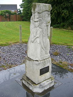
This "waymark" records the fact that Celia Fiennes passed through No Man's Heath on her great journey 1698[1]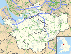
 No Mans Heath
No Mans Heath shown within CheshireOS grid reference SJ515479 Unitary authority Cheshire West and Chester Ceremonial county Cheshire Region North West Country England Sovereign state United Kingdom Post town MALPAS Postcode district SY14 Dialling code 01948 82 Police Cheshire Fire Cheshire Ambulance North West EU Parliament North West England UK Parliament Eddisbury List of places: UK • England • Cheshire No Mans Heath, which is known locally as Nomansheath, is a village in the unitary authority of Cheshire West and Chester and the ceremonial county of Cheshire, England. It lies two miles east of the village of Malpas and 5 miles (8 km) north west of Whitchurch, Shropshire. Originally on the A41 road, there is now a bypass. Bickleywood is a very small settlement about 1 km to the east.
There is no church in the village, due to the proximity of the church in Tushingham. But there are The Wheatsheaf Inn, a non-conformist chapel (disused) and a small telephone exchange (which was called Noman's Heath in the days when exchanges had names) in close proximity to one-another.
The southern section of the Sandstone Trail 30-mile footpath passes just east the village, while the 200-mile Marches Way footpath passes just south. The Sustrans Regional Route 70 cycleway passes through the village, running out from Malpas.
Just over two miles east of the village is the 19th century Cholmondeley Castle and gardens. Just to the north is the well preserved Iron Age hillfort of Maiden Castle, spectacularly sited above the Dee valley.
The Whitchurch and Tattenhall Railway used to pass within a kilometre of the village but the nearest station was Malpas railway station which was nearly three kilometres away and actually in Hampton Heath.
Macefen
The other No Man's Heath in England probably gets its name from lying close to four different counties. Similarly this settlement probably gets its name from straddling four different civil parishes: Malpas, Hampton, Bickley and Macefen[citation needed].
Kelly's Directory of Cheshire for 1896 does not list No Man's Heath and makes no mention under Hampton, which is listed under Malpas. Kelly's Directory for 1902 shows No Mans Heath merely as a sub-post office under Hampton. In their directory for 1914 the entry is very similar except for the addition of a telephone and an apostrophe on Man's.
References
- ^ Local authority website page about the Celia Fiennes Waymark
Ceremonial county of Cheshire Cheshire Portal Unitary authorities Major settlements Alsager • Birchwood • Bollington • Chester • Congleton • Crewe • Ellesmere Port • Frodsham • Knutsford • Macclesfield • Middlewich • Nantwich • Neston • Northwich • Poynton • Runcorn • Sandbach • Warrington • Widnes • Wilmslow • Winsford
See also: List of civil parishes in CheshireRivers Topics History • MuseumsCategories:- Villages in Cheshire


Wikimedia Foundation. 2010.