- New Guinea
-
New Guinea (Papua Island) 
Geography Location Melanesia Coordinates 5°30′S 141°00′E / 5.5°S 141°ECoordinates: 5°30′S 141°00′E / 5.5°S 141°E Archipelago Malay archipelago Area 786,000 km2 (303,500 sq mi) Area rank 2nd Highest elevation 4,884 m (16,024 ft) Highest point Puncak Jaya Country Provinces Papua
West PapuaProvinces Central
Simbu
Eastern Highlands
East Sepik
Enga
Gulf
Madang
Morobe
Oro
Southern Highlands
Western
Western Highlands
West Sepik
Milne Bay
National Capital DistrictDemographics Population ~ 7.5 million (as of 2005) Density 8 /km2 (21 /sq mi) Ethnic groups Papuan and Austronesian New Guinea (also known by other names) is the world's second largest island, after Greenland, covering a land area of 786,000 km2. Located in the southwest Pacific Ocean, it lies geographically to the east of the Malay Archipelago, with which it is sometimes included as part of a greater Indo-Australian Archipelago.[1] Geologically it is a part of the same tectonic plate and when world sea levels are low shares shorelines (which now lie 100 to 140 metres below sea level.[2]) combining with Australia and lands now inundated into the tectonic continent of Sahul,[3] [4] also known as Greater Australia.[5] The two landmasses became separated when the area now known as the Torres Strait flooded after the end of the last glacial period.
Anthropologically it is considered part of Melanesia. Politically, the western half of the island comprises two Indonesian provinces: Papua and West Papua. The eastern half forms the mainland of the country of Papua New Guinea. New Guinea has a population of about 7.5 million struggling against a hot humid damp rainy climate and constantly dripping jungle covering high mountain-dominated terrain with abrupt features rapidly descending to sea coast, all prone to several severe downpours during all seasons, resulting in a very low population density (8 inh/km2).
New Guinea is differentiated from its drier, flatter,[6] and less fertile[7][8] southern counterpart, Australia, by its much higher rainfall and its active volcanic geology, with its highest point, Puncak Jaya, reaching an elevation of 4,884 m (16,023 ft). Yet the two land masses share a similar animal fauna, with marsupials, including wallabies and possums, and the egg-laying monotreme, the spiny anteater, or echidna. Other than bats and some two dozen indigenous rodent genera,[9] there are no pre-human indigenous placental mammals. Pigs, several additional species of rats, and the ancestor of the New Guinea Singing Dog were introduced with human colonization.
The human presence on the island dates back at least 40,000 years to the oldest human migrations out of Africa. Research indicates that the highlands were an early and independent center of agriculture, with evidence of irrigation going back at least 10,000 years.[10] Given the time depth of its inhabitation and its highly fractured landscape, an unusually high number of languages are spoken on the island, with some 1,000 languages (a figure higher than that of most continents) having been catalogued out of an estimated world-wide pre-Columbian total of 6,000 human dialects. Most are classified as Papuan languages, a generally accepted geographical term which a minority of authors hold to be a genetic one. A number of Austronesian languages are spoken on the coast and on offshore islands.
In the 16th century Spanish explorers discovered the island and called it Nueva Guinea. In recent history western New Guinea was included in the Dutch East Indies colony. The Germans annexed the northern coast of the eastern half of the island as German New Guinea in their pre–World War I effort to establish themselves as a colonial power. Following the Treaty of Versailles, the German portion was awarded to Australia (which had already claimed the southeast, named the Territory of Papua) as a League of Nations mandate. The eastern half of the island was granted independence from Australia as Papua New Guinea in 1975. The western half gained independence from the Dutch in 1961, but became part of Indonesia soon afterwards in controversial circumstances.[11]
Contents
Names
The island has been known with various names.
The name Papua is used from very early history to refer the island.[12] Its etymology is unclear,[12] one theory is that it is originated from Tidore language, the language used by Sultanate of Tidore that controlled parts of the island's coastal region.[13] The name came from papo (to unite) and negation ua, which mean not united or, territory that geographically far away and thus not united.[13]
Ploeg reports that the word papua is often said to derive from the Malay word papua or pua-pua, meaning 'frizzly-haired', referring to the highly curly hair of the inhabitants of these areas.[14] Another possibility, (put forward by Sollewijn Gelpke in 1993) is that it comes from the Biak phrase sup i papwa which means 'the land below [the sunset]' and refers to the islands west of the Bird's Head, as far as Halmahera. Whatever the origin of the name Papua, it came to be associated with this area, and more especially with Halmahera, which was known to the Portuguese by this name during the era of their colonisation in this part of the world.
When the Spanish and Portuguese explorers arrived in the island via Spice Islands, they also referred to the island as Papua.[13] However the name New Guinea would later be used by Westerners starting with Spanish explorer Yñigo Ortiz de Retez in 1545, referring to the similarities of the indigenous people's appearance with the natives of Guinea region of Africa.[13] The Dutch which arrived later under Lemaire and Schouten called it Schouten island, but later this name is used only to refer islands to the north of the coast of Papua proper, the Schouten Islands or Biak Island. When the Dutch colonized it as part of Netherlands East Indies they called it Nieuw Guinea.[13]
The name Irian was used in Indonesian language to refer the island and Indonesian province, as "Irian Jaya province". The name was promoted in 1945 by Marcus Kaisiepo,[12] brother of the future governor Frans Kaisiepo. It is taken from Biak language of Biak Island that means to rise, or rising spirit. This name of Irian is the name used in Biak language and other languages such as Serui, Merauke and Waropen languages.[13] The name was used until 2001 when the name Papua is used again for the island and the province. The name Irian which was originally favored by natives, now considered to be name imposed by Jakarta authority. [12]
Political divisions
 Political divisions of New Guinea
The island of New Guinea is divided politically into roughly equal halves across a north-south line:
- The western portion of the island located west of 141°E longitude, (except for a small section of territory to the east of the Fly River which belongs to Papua New Guinea) was formerly a Dutch colony, the Dutch East Indies, and after decolonization is now two Indonesian provinces:
-
- West Papua with Manokwari as its capital.
- Papua with the city of Jayapura as its capital.
- The eastern part forms the mainland of Papua New Guinea, which has been an independent country since 1975. It was formerly the Territory of Papua and New Guinea governed by Australia, consisting of the Trust Territory of New Guinea ((northeastern quarter, formerly German New Guinea), and the Territory of Papua (southeastern quarter). The country consists of four regions:
-
- Papua, consisting of Western, Gulf, Central, Oro (Northern) and Milne Bay provinces.
- Highlands, consisting of Southern Highlands, Enga Province, Western Highlands, Simbu and Eastern Highlands provinces.
- Momase, consisting of Morobe, Madang, East Sepik and Sandaun (West Sepik) provinces.
- Islands, consisting of Manus, West New Britain, East New Britain and New Ireland provinces, and the Bougainville Autonomous Province.
- Each province has an administration headed by a governor who is also a member of the national parliament.
People

The current population of the island of New Guinea is about 7.5 million. Many believe human habitation on the island dates to as early as 40,000 B.C.,[15] and first settlement possibly dated back to 60,000 years ago has been proposed. The island is presently populated by very nearly a thousand different tribal groups and a near-equivalent number of separate languages, which makes New Guinea the most linguistically diverse area in the world. Ethnologue's 14th edition lists 826 languages of Papua New Guinea and 257 languages of Irian Jaya, total 1073 languages, with 12 languages overlapping. They fall into one of two groups, the Papuan languages and the Austronesian languages. The separation was not merely linguistic; warfare among societies was a factor in the evolution of the men's house: separate housing of groups of adult men, from the single-family houses of the women and children, for mutual protection against the other groups. Pig-based trade between the groups and pig-based feasts are a common theme with the other peoples of southeast Asia and Oceania. Most societies practice agriculture, supplemented by hunting and gathering.
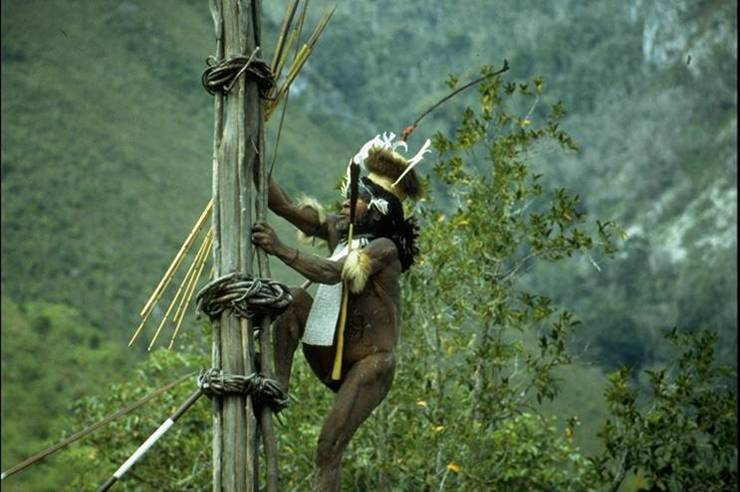
 Kurulu Village War Chief at Baliem Valley
The great variety of the island's indigenous populations are frequently assigned to one of two main ethnological divisions, based on archaeological, linguistic and genetic evidence: the Papuan and Austronesian groups.[16]
Current evidence indicates that the Papuans (who constitute the majority of the island's peoples) are descended from the earliest human inhabitants of New Guinea. These original inhabitants first arrived in New Guinea at a time (either side of the Last Glacial Maximum, approx 21,000 years ago) when the island was connected to the Australian continent via a land bridge, forming the landmass known as Sahul. These peoples had made the (shortened) sea-crossing from the islands of Wallacea and Sundaland (the present Malay Archipelago) by at least 40,000 years ago, subsequent to the dispersal of peoples from Africa (circa) 50,000 - 70,000 years ago.[citation needed]
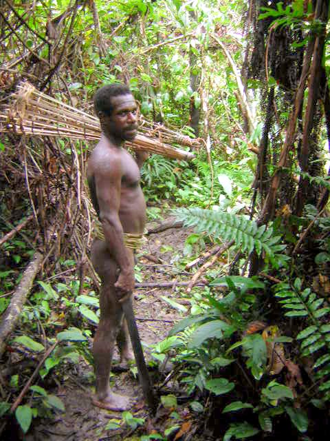
 Korowai tribesman
The ancestral Austronesian peoples are believed to have arrived considerably later, approximately 3,500 years ago, as part of a gradual seafaring migration from Southeast Asia, possibly originating in Taiwan. Austronesian-speaking peoples colonized many of the offshore islands to the north and east of New Guinea, such as New Ireland and New Britain, with settlements also on the coastal fringes of the main island in places. Human habitation of New Guinea over tens of thousands of years has led to a great deal of diversity, which was further increased by the later arrival of the Austronesians and the more recent history of European and Asian settlement through events like transmigration.
Large swathes of New Guinea are yet to be explored by scientists and anthropologists. The Indonesian province of West Papua is home to an estimated 44 uncontacted tribal groups.[17]
Biodiversity and ecology
Main article: Fauna of New GuineaWith some 786,000 km² of tropical land — less than one-half of one percent (0.5%) of the Earth's surface — New Guinea has an immense biodiversity, containing between 5 and 10 percent of the total species on the planet. This percentage is about the same amount as that found in the United States or Australia. A high percentage of New Guinea's species are endemic, and thousands are still unknown to science: probably well over 200,000 species of insect, between 11,000 to 20,000 plant species; over 650 resident bird species, including 37 species of birds of paradise and bowerbirds, parrots, and cassowaries; over 400 amphibians; 455 butterfly species; marsupials and monotremes including Bondegezou, Goodfellow's Tree-kangaroo, Huon Tree-kangaroo, Long-beaked Echidna, Tenkile, Agile Wallaby, Alpine Wallaby, cuscuses and possums; and various other mammal species[citation needed]. Most of these species are shared, at least in their origin, with the continent of Australia, which was until fairly recent geological times, part of the same landmass (see Australia-New Guinea for an overview). The island is so large that it is considered 'nearly a continent' in terms of its biological distinctiveness.
In the period from 1998 to 2008, conservationists have found 1,060 new species in New Guinea, they were 218 kinds of plants, 43 reptiles, 12 mammals, 580 invertebrates, 134 amphibians, 2 birds and 71 fish.[18]
 The Western Crowned Pigeon is native to New Guinea.
 The floristic region of Malesia
Biogeographically, New Guinea is part of Australasia rather than the Indomalayan realm, although New Guinea's flora has many more affinities with Asia than its fauna, which is overwhelmingly Australian. Botanically, New Guinea considered part of Malesia, a floristic region that extends from the Malay Peninsula across Indonesia to New Guinea and the East Melanesian Islands. The flora of New Guinea is a mixture of many tropical rainforest species with origins in Asia, together with typically Australasian flora. Typical southern hemisphere flora include the conifers Podocarpus and the rainforest emergents Araucaria and Agathis, as well as tree ferns and several species of Eucalyptus.
New Guinea has 284 species and six orders of mammals: (monotremes, three orders of marsupials, rodents and bats); 195 of the mammal species (69%) are endemic. New Guinea has 578 species of breeding birds, of which 324 species are endemic. The island's frogs are one of the most poorly known vertebrate groups, currently totalling 282 species, but this number is expected to double or even triple when all species have been documented. New Guinea has a rich diversity of coral life and 1,200 species of fish have been found. Also about 600 species of reef-building coral — the latter equal to 75 percent of the world’s known total. The entire coral area covers 18 million hectares off a peninsula in northwest New Guinea.
Ecoregions
Terrestrial
According to the WWF, New Guinea can be divided into twelve terrestrial ecoregions:[19]
- Central Range montane rain forests
- Central Range sub-alpine grasslands
- Huon Peninsula montane rain forests
- New Guinea mangroves
- Northern New Guinea lowland rain and freshwater swamp forests
- Northern New Guinea montane rain forests
- Southeastern Papuan rain forests
- Southern New Guinea freshwater swamp forests
- Southern New Guinea lowland rain forests
- Trans Fly savanna and grasslands
- Vogelkop montane rain forests
- Vogelkop-Aru lowland rain forests
Freshwater
The WWF and Nature Conservancy divide New Guinea into five freshwater ecoregions:[20]
- Vogelkop–Bomberai
- New Guinea North Coast
- New Guinea Central Mountains
- Southwest New Guinea–Trans-Fly Lowland
- Papuan Peninsula
Marine
The WWF and Nature Conservancy identify several marine ecoregions in the seas bordering New Guinea:[21]
- Papua
- Bismarck Sea
- Solomon Sea
- Southeast Papua New Guinea
- Gulf of Papua
- Arafura Sea
History
See also: History of Papua New GuineaEarly History
 The continent of Sahul before the rising ocean sundered Australia and New Guinea after the last ice age
The first inhabitants of New Guinea arrived at least around 40,000 years ago, having travelled through the south-east Asian peninsula. These first inhabitants, from whom the Papuan people are probably descended, adapted to the range of ecologies and in time developed one of the earliest known agricultures. Remains of this agricultural system, in the form of ancient irrigation systems in the highlands of Papua New Guinea, are being studied by archaeologists. This work is still in its early stages so there is still uncertainty as to precisely what crop was being grown, or when/where agriculture arose. Sugar cane was cultivated for the first time in New Guinea around 6000 B.C.[22]
The gardens of the New Guinea Highlands are ancient, intensive permacultures, adapted to high population densities, very high rainfalls (as high as 10,000 mm/yr (400 in/yr)), earthquakes, hilly land, and occasional frost. Complex mulches, crop rotations and tillages are used in rotation on terraces with complex irrigation systems. Western agronomists still do not understand all practices, and it has been noted that native gardeners are as or more successful than most scientific farmers in raising certain crops.[23] There is evidence that New Guinea gardeners invented crop rotation well before western Europeans.[24] A unique feature of New Guinea permaculture is the silviculture of Casuarina oligodon, a tall, sturdy native ironwood tree, suited to use for timber and fuel, with root nodules that fix nitrogen. Pollen studies show that it was adopted during an ancient period of extreme deforestation.
In more recent millennia another wave of people arrived on the shores of New Guinea. These were the Austronesian people, who had spread down from Taiwan, through the South-east Asian archipelago, colonising many of the islands on the way. The Austronesian people had technology and skills extremely well adapted to ocean voyaging and Austronesian language speaking people are present along much of the coastal areas and islands of New Guinea. This Austronesian migrants are considered ancestors of most people in insular Southeast Asia form Sumatra, Java to Borneo and Sulawesi, and coastal new Guinea.[25]
Pre-Colonial History
File:PSM V52 D045 Papuan lake dwellings fart with a lakatoi fart under sail.jpgPapuan lake dwellings, 19th centuryWestern part of the island has been in contact with kingdoms in other parts of modern-day Indonesia. Negarakertagama mentioned region of Wanin in eastern Nusantara as part of Majapahit's tributary. This has been identified with Onin Peninsula, part of Bomberai Peninsula near the city of Fakfak.[26][27] The sultans of Tidore, in Maluku Islands, claimed sovereignty over various coastal part of the island.[28] During Tidore's rule, the main export of the island during this period is resins, spices, slaves and the highly priced feathers of Bird-of-Paradise.[28] Sultan Nuku, one of the most famous Tidore sultan who rebelled against Dutch colonization, called himself "Sultan of Tidore and Papua",[29] during his revolt in 1780s. He commanded loyalty from both Moluccan and Papuan chiefs, especially those of Raja Ampat Islands. Following Tidore's defeat, much of the territory it claimed in western part of New Guinea come under Dutch rule as part of Dutch East Indies.[29]
European Contact
The first European contact with New Guinea was by Portuguese and Spanish sailors in the 16th century. In 1526-27 the Portuguese explorer Jorge de Meneses saw the western tip of New Guinea and named it ilhas dos Papuas. In 1545 the Spaniard Yñigo Ortiz de Retez sailed along the north coast of New Guinea as far as the Mamberamo River near which he landed, naming the island 'Nueva Guinea'. The first map showing the whole island (as an island) was published in 1600 and shows it as 'Nova Guinea'. In 1606 Spanish navigator Luís Vaz de Torres explored the southern coast of New Guinea from Milne Bay to the Gulf of Papua including Orangerie Bay which he named Bahía de San Lorenzo. His expedition also discovered Basilaki Island naming it Tierra de San Buenaventura, which he claimed for Spain in July 1606.[30] On October 18 his expedition reached the western part of the island in present-day Indonesia, and also claimed the territory for the King of Spain.
 New Guinea from 1884-1919. The Netherlands controlled the western half of New Guinea, Germany the north-eastern part, and Britain the south-eastern part.
A successive European claim occurred in 1828, when the Netherlands formally claimed the western half of the island as Netherlands New Guinea. In 1883, following a short-lived French annexation of New Ireland, the British colony of Queensland annexed south-eastern New Guinea. However, the Queensland government's superiors in the United Kingdom revoked the claim, and (formally) assumed direct responsibility in 1884, when Germany claimed north-eastern New Guinea as the protectorate of German New Guinea (also styled Kaiser-Wilhelmsland). The first Dutch government posts were established in 1898 and in 1902 Manokwari on the North coast, Fak-Fak in the West and Merauke in the South at the border with British New Guinea.
The Germans, the Dutch and the British tried to suppress warfare and headhunting, which was once common between the villages of the populace.[31]
In 1905 the British government renamed their territory as the Territory of Papua, and in 1906 transferred total responsibility for it to Australia. During World War I, Australian forces seized German New Guinea, which in 1920 became the Territory of New Guinea, a League of Nations mandated territory of Australia. The Australian territories became collectively known as The Territories of Papua and New Guinea (until February 1942).
 Australian soldiers display Japanese flags they captured at Kaiapit, New Guinea in 1943.
Before about 1930, most European maps showed the highlands as uninhabited forests.[citation needed] When first flown over by aircraft, numerous settlements with agricultural terraces and stockades were observed. The most startling discovery took place on 4 August 1938, when Richard Archbold discovered the Grand Valley of the Baliem River which had 50,000 yet-undiscovered Stone Age farmers living in orderly villages. The people, known as the Dani, were the last society of its size to make first contact with the rest of the world.[32]
Since World War II
Netherlands New Guinea and the Australian territories were invaded in 1942 by the Japanese. The Australian territories were put under military administration and were known simply as New Guinea. The highlands, northern and eastern parts of the island became key battlefields in the South West Pacific Theatre of World War II. Papuans often gave vital assistance to the Allies, fighting alongside Australian troops, and carrying equipment and injured men across New Guinea. Following the return to civil administration, the Australian section was known as the Territory of Papua-New Guinea (1945–49) and then as Papua and New Guinea. Although the rest of the Dutch East Indies achieved independence as Indonesia on 27 December 1949, the Netherlands regained control of western New Guinea.
During the 1950s the Dutch government began to prepare Netherlands New Guinea for full independence and allowed elections in 1959; the elected New Guinea Council took office on 5 April 1961. The Council decided on the name of West Papua for the territory, along with an emblem, flag, and anthem to complement those of the Netherlands. On 1 October 1962, the Dutch handed over the territory to the United Nations Temporary Executive Authority, until 1 May 1963, when Indonesia took control. The territory was renamed West Irian and then Irian Jaya. In 1969 Indonesia, under the 1962 New York Agreement, organised a referendum named the Act of Free Choice, in which Papuan tribal elders reached a consensus to continue union with Indonesia.[citation needed]
 Map of New Guinea, with place names as used in English in the 1940s
There has been resistance to Indonesian integration and occupation, both through civil disobedience (such as Morning Star flag raising ceremonies) and via the formation of the Organisasi Papua Merdeka (OPM, or Free Papua Movement) in 1965. Amnesty International has estimated more than 100,000 Papuans, one-sixth of the population, have died as a result of government-sponsored violence against West Papuans.[33]
From 1971, the name Papua New Guinea was used for the Australian territory. On 16 September 1975, Australia granted full independence to Papua New Guinea.
In 2000, Irian Jaya was formally renamed "The Province of Papua" and a Law on Special Autonomy was passed in 2001. The Law established a Papuan People's Assembly (MRP) with representatives of the different indigenous cultures of Papua. The MRP was empowered to protect the rights of Papuans, raise the status of women in Papua, and to ease religious tensions in Papua; block grants were given for the implementation of the Law as much as $266 million in 2004.[34] The Indonesian courts' enforcement of the Law on Special Autonomy blocked further creation of subdivisions of Papua: although President Megawati Sukarnoputri was able to create a separate West Papua province in 2003 as a fait accompli, plans for a third province on western New Guinea were blocked by the courts. (King, 2004, p. 91) Critics argue that the Indonesian government has been reluctant to establish or issue various government implementing regulations so that the legal provisions of special autonomy could be put into practice, and as a result special autonomy in Papua has failed.[35]
Geography
 New Guinea located with respect to Melanesia
 Topographical map of New Guinea.
New Guinea is an island in the north of the continent of Sahul, also known as Greater Australia. It is isolated by the Arafura Sea to the west and the Torres Strait and Coral Sea to the east. Sometimes considered to be the easternmost island of the Malay archipelago, it lies north of Australia's Top End, Gulf of Carpentaria and Cape York peninsula, and west of the Bismarck Archipelago and the Solomon Islands Archipelago.
Prior to the 1970s, archaeologists called the single Pleistocene landmass by the name Australasia,[3] although this word is most often used for a wider region that includes lands like New Zealand that are not on the same continental shelf. In the early 1970s they introduced the term Greater Australia for the Pleistocene continent.[3] Then at a 1975 conference and consequent publication,[4] they extended the name Sahul from its previous use for just the Sahul Shelf to cover the continent.[3]
A central east-west mountain range dominates the geography of New Guinea, over 1,600 km (1,000 mi) in total length. The western half of the island of New Guinea contains the highest mountains in Oceania, rising up to 4,884 m (16,024 ft) high, and ensuring a steady supply of rain from the equatorial atmosphere. The tree line is around 4,000 m (13,100 ft) elevation and the tallest peaks contain permanent equatorial glaciers—which have been retreating since at least 1936.[36][37][38] Various other smaller mountain ranges occur both north and west of the central ranges. Except in high elevations, most areas possess a warm humid climate throughout the year, with some seasonal variation associated with the northeast monsoon season.
The Highest Peaks on the Island of New Guinea are:
- Puncak Jaya, sometimes known by its former Dutch name Carstensz Pyramid, is a mist covered limestone mountain peak on the Indonesian side of the border. At 4,884 metres (16,024 ft), Puncak Jaya makes New Guinea the world's fourth highest landmass.
- Puncak Mandala located in Papua, is the second highest peak on the island at 4,760 metres (15,617 ft).
- Puncak Trikora also in Papua is 4,750 metres (15,584 ft).
- Mount Wilhelm is the highest peak on the PNG side of the border at 4,509 metres (14,793 ft). Its granite peak is the highest point of the Bismarck Range.
- Mount Giluwe 4,368 metres (14,331 ft) is the second highest summit in PNG it is also the highest volcanic peak in Oceania.
Another major habitat feature is the vast southern and northern lowlands. Stretching for hundreds of kilometres, these include lowland rainforests, extensive wetlands, savanna grasslands, and some of the largest expanses of mangrove forest in the world. The southern lowlands are the site of Lorentz National Park, also a UNESCO World Heritage Site.
The Sepik, Mamberamo, Fly, and Digul rivers are the island's major river systems that drain in roughly northeast, northwest, southeast, and southwest directions respectively. Many of these rivers have broad areas of meander and result in large areas of lakes and freshwater swamps.
New Guinea contains many of the world’s ecosystem types: glacial, alpine tundra, savanna, montane and lowland rainforest, mangroves, wetlands, lake and river ecosystems, seagrasses, and some of the richest coral reefs on the planet.
References
- ^ Wallace, Alfred Russell (1863). "On the Physical Geography of the Malay Archipelago". http://web2.wku.edu/~smithch/wallace/S078.htm. Retrieved 30 November 2009.; Wallace, Alfred Russel (1869). The Malay Archipelago. London: Macmillan and Co. p. 2.
- ^ "Big Bank Shoals of the Timor Sea: An environmental resource atlas". Australian Institute of Marine Science. 2001. http://www.aims.gov.au/c/document_library/get_file?uuid=703cba58-6526-44e4-91eb-7ef84e4ba25d&groupId=30301. Retrieved 2006-08-28.
- ^ a b c d {{cite conference |first=Chris |last=Ballard |authorlink= |title=Stimulating minds to fantasy? A critical etymology for Sahul |booktitle=Sahul in review: Pleistocene archaeology in Australia, New Guinea and island Melanesia |pages=19–20 |publisher=Australian National University | location= Canberra |year=1993 |id=ISBN 0-7315-1540-4 }}
- ^ a b Allen, J.; J. Golson and R. Jones (eds) (1977). Sunda and Sahul: Prehistorical studies in Southeast Asia, Melanesia and Australia. London: Academic Press. ISBN 0-12-051250-5.
- ^ Allen, Jim; Gosden, Chris; Jones, Rhys; White, J. Peter (1988). "Pleistocene dates for the human occupation of New Ireland, northern Melanesia". Nature 331 (6158): 707–709. doi:10.1038/331707a0.
- ^ Macey, Richard (21 January 2005). "Map from above shows Australia is a very flat place". The Sydney Morning Herald. http://www.smh.com.au/news/National/Map-from-above-shows-Australia-is-a-very-flat-place/2005/01/21/1106110947946.html. Retrieved 5 April 2010.
- ^ Kelly, Karina (13 September 1995). "A Chat with Tim Flannery on Population Control". Australian Broadcasting Corporation. http://www.abc.net.au/quantum/info/q95-19-5.htm. Retrieved 23 April 2010. "Well, Australia has by far the world's least fertile soils".
- ^ Grant, Cameron (August 2007). "Damaged Dirt". The Advertiser. http://www.1degree.com.au/files/AdvertiserPartworks_Part3_Page8.pdf?download=1&filename=AdvertiserPartworks_Part3_Page8.pdf. Retrieved 23 April 2010. "Australia has the oldest, most highly weathered soils on the planet."
- ^ Lidicker, W. Z., Jr. (1968). "A Phylogeny of New Guinea Rodent Genera Based on Phallic Morphology". Journal of Mammalogy 49 (4): 609–643. doi:10.2307/1378724.
- ^ "The team also dated features consistent with the planting, digging, and tethering of plants and localized drainage systems to 10,000 years ago. Mounds constructed to plant water-intolerant plants such as bananas, sugarcane, and yams are dated to about 6,500 years ago." "Was Papua New Guinea an Early Agriculture Pioneer?" By John Roach, for National Geographic News, June 23, 2003
- ^ http://www.gwu.edu/~nsarchiv/NSAEBB/NSAEBB12/ (authorization required)
- ^ a b c d Pickell, David; Kal Müller (2002). Between the tides: a fascinating journey among the Kamoro of New Guinea. Tuttle Publishing. pp. 153. ISBN 0794600727, 9780794600723. http://books.google.com/books?id=WUtz2hjvPvMC&pg=PA153.
- ^ a b c d e f Singh, Bilveer (2008). Papua: geopolitics and the quest for nationhood. Transaction Publishers. pp. 26. ISBN 1412807050, 9781412807050. http://books.google.com/books?id=pwbO-uRZQx0C&pg=PA26.
- ^ Ploeg, Anton (2002). "'De Papoea' What's in a name?". Asia Pacific Journal of Anthropology 3 (1): 75–101. doi:10.1080/14442210210001706216.
- ^ Groube, Chappell, et al., Letter to Nature Dec 1986
- ^ Encyclopædia Britannica Online
- ^ First contact with isolated tribes?
- ^ http://www.guardian.co.uk/environment/2011/jun/26/new-guinea-new-species-wwf
- ^ Wikramanayake, Eric; Eric Dinerstein; Colby J. Loucks; et al. (2002). Terrestrial Ecoregions of the Indo-Pacific: a Conservation Assessment. Island Press; Washington, DC
- ^ Abell, Robin; Thieme, Michele L.; et al. (2008). "Freshwater Ecoregions of the World: A New Map of Biogeographic Units for Freshwater Biodiversity Conservation". Bioscience 58 (5): 403–414. doi:10.1641/B580507.
- ^ Spalding, Mark D.; Fox, Helen E.; Allen, Gerald R.; Davidson, Nick; et al. (2007). "Marine Ecoregions of the World: A Bioregionalization of Coastal and Shelf Areas". Bioscience 57 (7): 573–583. doi:10.1641/B570707.
- ^ http://www.plantcultures.org/plants/sugar_cane_history_early_origins_and_spread.html
- ^ Diamond, Jared. Collapse. (German translation), Frankfurt 2005, p. 350.
- ^ Diamond, Jared. Collapse. (German translation), Frankfurt 2005, p. 351.
- ^ Austronesian diaspora and the ethnogeneses of people in Indonesian archipelago:proceedings of the international symposium. Yayasan Obor Indonesia. 2006. pp. 61. ISBN 9792624368, 9789792624366. http://books.google.com/books?id=Szvr5hUtD5kC&pg=PA61.
- ^ Riana, I Ketut (2009). Nagara Krtagama : Criticism on Desawarnana or Nagarakrtagama, an Old Javanese literature on the golden era of Majapahit Kingdom.. Penerbit Buku Kompas. pp. 36. ISBN 9797094332, 9789797094331. http://books.google.com/books?id=A5p9tEO1_gUC.
- ^ Moore, Clive (2003). New Guinea: crossing boundaries and history. University of Hawaii Press. pp. 270. ISBN 0824824857, 9780824824853. http://books.google.com/books?id=Sn6-x8lo3a8C.
- ^ a b Crocombe, R. G. (2007). Asia in the Pacific Islands: replacing the West. University of the South Pacific. Institute of Pacific Studies. pp. 281. ISBN 9820203880, 9789820203884. http://books.google.com/books?id=iDg9oAkwsXAC&pg=PA281.
- ^ a b Satrio Widjojo, Muridan (2009). The revolt of Prince Nuku: cross-cultural alliance-making in Maluku, c.1780-1810. BRILL. ISBN 9004172017, 9789004172012. http://books.google.com/books?id=3wsrumdSvrUC.
- ^ Translation of Torres’ report to the king in Collingridge, G. (1895) Discovery of Australia p.229-237. Golden Press Edition 1983, Gladesville, NSW. ISBN 0 855589566
- ^ White, Osmar. Parliament of a Thousand Tribes, Heinemann, London, 1965
- ^ Diamond, Jared. The Third Chimpanzee. Harper Collins, 1993
- ^ Report claims secret genocide in Indonesia - University of Sydney
- ^ Pogau, Oktovianus (2011-01-13). "The Thinker: Pending in Papua". Jakarta Globe. http://www.thejakartaglobe.com/columns/the-thinker-pending-in-papua/416800. Retrieved 2011-04-18.
- ^ Special Autonomy Issue - ETAN
- ^ Prentice, M.L. and G.S. Hope (2006). "Climate of Papua". Ch. 2.3 in Marshall, A.J., and Beehler, B.M. (eds.). The Ecology of Papua. Singapore: Periplus Editions. The authors note that "The magnitude of the recession of the Carstensz Glaciers, its causes, and its implications for local, regional, and global climate change are only qualitatively known. The recession of the Carstensz Glaciers from ~11 km2 in 1942 to 2.4 km2 by 2000 represents about an 80% decrease in ice area."
- ^ Kincaid and Kline, "Retreat of the Irian Jaya Glaciers from 2000 to 2002 as Measured from IKONOS Satellite Images", paper presented at 61st Eastern Snow Conference, Portland, Maine, 2004
- ^ Recent Global Glacier Retreat Overview
External links
- Facsimile of material from "The Discovery of New Guinea" by George Collingridge
- Scientists hail discovery of hundreds of new species in remote New Guinea
- PapuaWeb
List of resources about traditional arts and culture of OceaniaArt ahu · Australia · Austronesia · Cook Islands · Hawaiʻi · kapa (Hawaiʻi) · lei (Hawaii) · magimagi · Māori · moai · New Zealand · nguzu nguzu · Oceania · Papua New Guinea · reimiro · tā moko · tapa ["masi" (Fiji), "ngatu" (Tonga), "siapo" (Sāmoa), " ʻuha" (Rotuma)] · tabua · ta'ovala · tattoo · tēfui · tivaivaiBroad culture Geo-specific, general Australia · Australian Aboriginal astronomy · Austronesia · Caroline Islands, -Pwo · Chatham Islands · Cook Islands · Easter Island · Fiji, -Lau Islands, -traditions and ceremonies · Guam · Hawaiʻi, -Lomilomi massage · Kiribati · French Polynesia's Marquesas Islands · Marshall Islands, -Stick charts of · Federated States of Micronesia · Nauru · New Caledonia · New Zealand · Niue · Norfolk Island · Palau · Papua New Guinea · Pitcairn Islands · Sāmoa · Solomon Islands · Tonga · Torres Strait Islands · Tuvalu · Vanuatu · Wallis and Futuna · Yap, -navigation, -Weriyeng navigation schoolCanoes Aboriginal Dugout · Alingano Maisu · Drua · Dugout (boat) · Hawaiʻiloa · Hōkūleʻa · Modern Hawaiian outrigger · Māori migration · Outrigger · Polynesian sailing · Proa · Waka,-List of · WalapDance Festivals Australia's Garma Festival · Hawaiʻi's Aloha Festivals, Merrie Monarch Festival, and World Invitational Hula Festival · Fiji · New Zealand's Pasifika Festival · The Pacific Community's Festival of Pacific Arts · Festivals in Papua New GuineaLanguages by areaLanguages of Oceania Sovereign states - Australia
- East Timor (Timor-Leste)
- Fiji
- Indonesia
- Kiribati
- Marshall Islands
- Federated States of Micronesia
- Nauru
- New Zealand
- Palau
- Papua New Guinea
- Samoa
- Solomon Islands
- Tonga
- Tuvalu
- Vanuatu
Dependencies and
other territories- American Samoa
- Christmas Island
- Cocos (Keeling) Islands
- Cook Islands
- Easter Island
- French Polynesia
- Guam
- Hawaii
- New Caledonia
- Niue
- Norfolk Island
- Northern Mariana Islands
- Pitcairn Islands
- Tokelau
- Wallis and Futuna
by categoryLiterature Literature of Oceania Sovereign states - Australia
- East Timor (Timor-Leste)
- Fiji
- Indonesia
- Kiribati
- Marshall Islands
- Federated States of Micronesia
- Nauru
- New Zealand
- Palau
- Papua New Guinea
- Samoa
- Solomon Islands
- Tonga
- Tuvalu
- Vanuatu
Dependencies and
other territories- American Samoa
- Christmas Island
- Cocos (Keeling) Islands
- Cook Islands
- Easter Island
- French Polynesia
- Guam
- Hawaii
- New Caledonia
- Niue
- Norfolk Island
- Northern Mariana Islands
- Pitcairn Islands
- Tokelau
- Wallis and Futuna
Music Austral Islands (French Polynesia) · Australia · Austronesia · Cook Islands · Easter Island · Fiji · Guam · Hawaiʻi · Kiribati · Lali · Māori · Melanesia · Northern Mariana Islands · Micronesia · Federated States of Micronesia · Nauru · New Caledonia · New Zealand · Niue · Palau · Papua New Guinea · Polynesia · Sāmoa · Slit drum · Solomon Islands · Tahiti · Tokelau · Tonga · Tuvalu · Vanuatu · Wallis and FutunaMythology Australian Aboriginal · Fijian · Māori · Melanesian · Menehune · Micronesian · Oceanian legendary creatures · Polynesian · Rapa Nui · VanuatuPeople Indigneous Australian · Austronesian · Chamorro · Chatham Islander (Moriori or Rekohu) · Fijian · Hawaiian (kānaka maoli) · Māori · Marshallese · Melanesian · Micronesian · Negrito · Norfolk Islander · Papuan · Polynesian · Indigenous Polynesian (Mā’ohi) · Rapanui · Rotuman · Samoan · Tahitian · Tongan · Torres Strait IslanderReligion Religion in Oceania Sovereign states Dependencies and
other territories- American Samoa
- Christmas Island
- Cocos (Keeling) Islands
- Cook Islands
- Easter Island
- French Polynesia
- Guam
- Hawaii
- New Caledonia
- Niue
- Norfolk Island
- Northern Mariana Islands
- Pitcairn Islands
- Tokelau
- Wallis and Futuna
Not included: Oceanian: cinema, (indigenous) currency, dress, folkore, cuisine. Also see Category:Oceanian culture.Categories:- New Guinea
- Divided regions
- International islands
- Geography of Oceania


Wikimedia Foundation. 2010.