- Montana
-
This article is about the U.S. state of Montana. For other uses, see Montana (disambiguation).
State of Montana 

Flag Seal Nickname(s): "Big Sky Country", "The Treasure State" Motto(s): "Oro y Plata" (Spanish: Gold and Silver) 
Official language(s) English Demonym Montanan Capital Helena Largest city Billings Largest metro area Billings Metropolitan Area Area Ranked 4th in the U.S. - Total 147,042 sq mi
(381,156 km2)- Width 630 miles (1,015 km) - Length 255 miles (410 km) - % water 1 - Latitude 44° 21′ N to 49° N - Longitude 104° 2′ W to 116° 3′ W Population Ranked 44th in the U.S. - Total (2010) 989,415 - Density 6.8/sq mi (2.51/km2)
Ranked 48th in the U.S.Elevation - Highest point Granite Peak[1][2][3]
12,807 ft (3903.5 m)- Mean 3,400 ft (1040 m) - Lowest point Kootenai River at Idaho border[2][3]
1,804 ft (550 m)Before statehood Montana Territory Admission to Union November 8, 1889 (41st) Governor Brian Schweitzer (D) Lieutenant Governor John Bohlinger (R) Legislature Montana Legislature - Upper house Senate - Lower house House of Representatives U.S. Senators Max Baucus (D)
Jon Tester (D)U.S. House delegation Denny Rehberg (R) (list) Time zone Mountain: UTC -7/DST-6 Abbreviations MT Mont. US-MT Website mt.gov Montana
 i/mɒnˈtænə/ is a state in the Western United States. The western third of Montana contains numerous mountain ranges. Smaller, "island ranges" are found in the central third of the state, for a total of 77 named ranges of the Rocky Mountains. This geographical fact is reflected in the state's name, derived from the Spanish word montaña (mountain). Montana has several nicknames, none official,[4] including: "Big Sky Country" and "The Treasure State", and slogans that include "Land of the Shining Mountains" and more recently, "The Last Best Place".[5][6] The state ranks fourth in area, but 44th in population, and accordingly has the third-lowest population density in the United States.[7] The economy is primarily based on services, with ranching, wheat farming, oil and coal mining in the east, and lumber, tourism, and hard rock mining in the west.[8] Millions of tourists annually visit Glacier National Park, the Little Bighorn Battlefield National Monument, and three of the five entrances to Yellowstone National Park.[9]
Geography
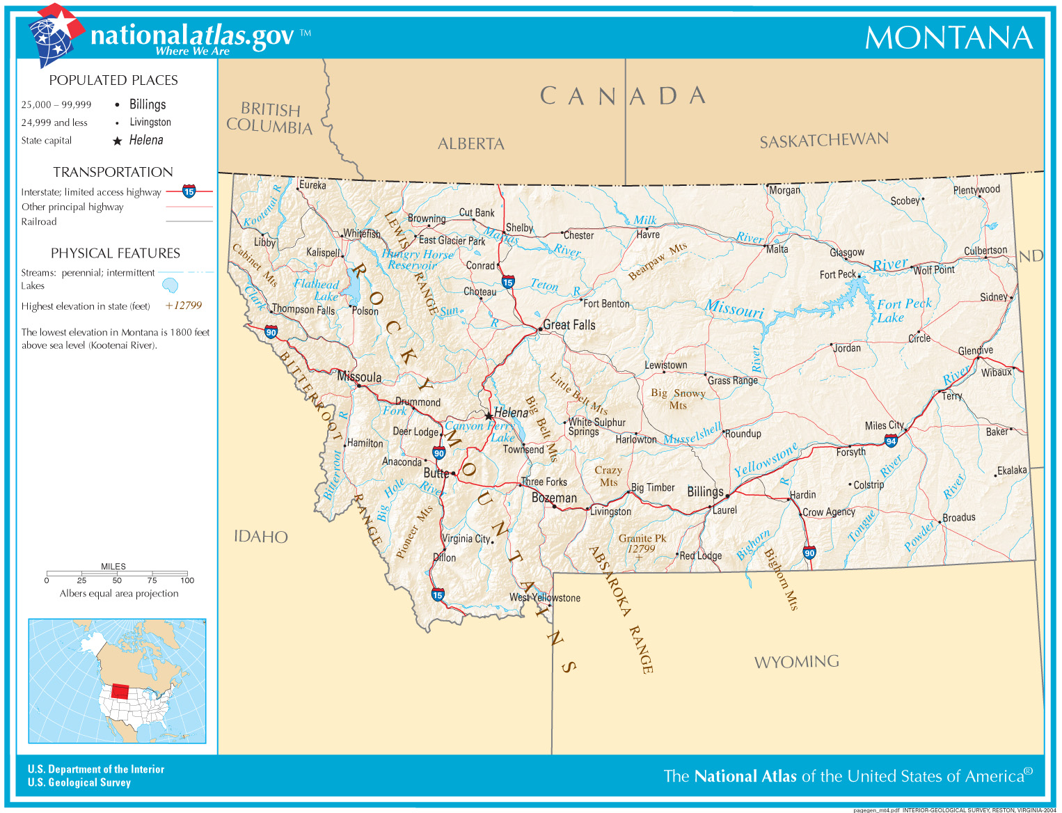
See also: Regional designations of Montana, Ecological systems of Montana, List of mountain ranges in Montana, and List of Forests in Montana Map of Montana
With a land area of 147,046 square miles (380,850 km2) Montana is slightly larger than Japan and slightly smaller than Paraguay. It is the fourth largest state in the United States (after Alaska, Texas, and California), the largest landlocked U.S. state, and the 56th largest national state/province subdivision in the world. To the north, Montana shares a 545-mile (877 km) border with three Canadian provinces: British Columbia, Alberta, and Saskatchewan. To the east, the state borders North Dakota and South Dakota. To the south lies Wyoming and to the west and southwest is Idaho.
The topography of the state is diverse, and roughly defined by the Continental Divide, which runs on an approximate diagonal line through the state from northwest to south-central, splitting it into two distinct eastern and western regions. Montana is well known for its mountainous western region, most of which is geologically and geographically part of the Northern Rocky Mountains. The Absaroka and Beartooth ranges in the south are technically part of the Central Rocky Mountains. About 60% of the state is prairie, part of the northern Great Plains. Nonetheless, even east of the Continental Divide and the Rocky Mountain Front, there are a number of isolated "island ranges" that dot the prairie landscape. This island range region covers most of the central third of the state.
The Bitterroot Mountains—one of the longest continuous ranges in the entire Rocky Mountain chain from Alaska to Mexico—divide the state from Idaho to the west, with the southern third of the range blending into the Continental Divide. Mountain ranges between the Bitterroots and the top of the Continental Divide include the Cabinet Mountains, the Anaconda Range (informally called the "Pintlars"), the Missions, the Garnet Range, Sapphire Mountains, and Flint Creek Range.
 Montana terrain
The northern section of the Divide, where the mountains give way rapidly to prairie, is known collectively as the Rocky Mountain Front. The front is most pronounced in the Lewis Range, located primarily in Glacier National Park. Due to the configuration of mountain ranges in Glacier National Park, the Northern Divide (which begins in Alaska's Seward Peninsula) crosses this region and turns east in Montana at Triple Divide Peak. It causes the Waterton River, Belly, and Saint Mary rivers to flow north into Alberta, Canada. There they join the Saskatchewan River, which ultimately empties into Hudson Bay.
East of the divide, several parallel ranges march across the southern half of the state, including the Gravelly Range, the Tobacco Roots, the Madison Range, Gallatin Range, Big Belt Mountains, Bridger Mountains, Absaroka Mountains, and the Beartooth Mountains. The Beartooth Plateau is the largest continuous land mass over 10,000 feet (3,000 m) high in the continental United States. It contains the highest point in the state, Granite Peak, 12,799 feet (3,901 m) high.
 St. Mary Lake in Glacier National Park
Between the mountain ranges are many scenic valleys, rich in agricultural resources and rivers, and possessing multiple opportunities for tourism and recreation. Among the best-known areas are the Big Hole Valley, Bitterroot Valley, Gallatin Valley, Flathead Valley, and Paradise Valley.
East and north of this transition zone are expansive, sparsely populated Northern Plains, with rolling tableland prairies, "island" mountain ranges, and scenic badlands extending into the Dakotas and Wyoming, as well as Alberta and Saskatchewan, Canada. The isolated island ranges east of the Divide include the Bear Paw Mountains, Castle Mountains, Crazy Mountains, Highwood Mountains, Judith Mountains, Little Belt Mountains, Little Rocky Mountains, Snowy Mountains, Sweet Grass Hills, Bull Mountains, the Pryor Mountains south of Billings, and—in the southeastern corner of the state near Ekalaka—the Long Pines.
The area east of the divide in the north-central portion of the state is known for the Missouri Breaks and other significant rock formations. Three stately buttes south of Great Falls are familiar landmarks. The three: Square, Shaw, and Crown buttes, are made of igneous rock, which is dense and has withstood weathering for many years. The underlying surface consists of shale. Many areas around these buttes are covered with clay surface soils, which have been derived from the weathering of the Colorado Formation. Farther east, areas such as Makoshika State Park near Glendive and Medicine Rocks State Park near Ekalaka also highlight some of the most scenic badlands regions in the state.
The Hell Creek Formation is a major source of dinosaur fossils. Paleontologist Jack Horner, of the Museum of the Rockies in Bozeman, brought this formation to the world's attention with several major finds.
Rivers
See also: List of rivers of Montana and List of lakes in MontanaMontana also contains numerous rivers, many of which are known for "blue-ribbon" trout fishing, while also providing most of the water needed by residents of the state, and hydropower. Montana is one of few geographic areas in the world whose rivers form parts of three major watersheds (i.e. where two continental divides intersect). Its rivers feed the Pacific Ocean, the Gulf of Mexico, and Hudson Bay, and the watershed areas are divided atop Triple Divide Peak in Glacier National Park.
 Missouri Breaks region in central Montana
West of the divide, the Clark Fork of the Columbia (not to be confused with the Clarks Fork of the Yellowstone River) rises in the Rocky Mountains near Butte and flows northwest to Missoula, where it is joined by the Blackfoot River and Bitterroot River, and further downstream by the Flathead River, before entering Idaho near Lake Pend Oreille. There it meets the Columbia River, which flows to the Pacific Ocean. The Clark Fork discharges the greatest volume of water of any river exiting the state. The Flathead and Kootenai rivers also drain major portions of the western half of the state.
East of the divide, the Missouri River—formed by the confluence of the Jefferson, Madison, and Gallatin rivers—crosses the central part of the state, flows through the Missouri breaks and enters North Dakota. The Yellowstone River rises in Yellowstone Park in Wyoming, flows north to Livingston, Montana, where it then turns east and flows through Billings, continuing across the state until it joins the Missouri River a few miles east of the North Dakota boundary. The Yellowstone River is the longest undammed, free-flowing river in the contiguous United States. Other major Montana tributaries of the Missouri include the Milk, Marias, Tongue, and Musselshell rivers. Montana claims the disputed title of possessing the "world's shortest river," the Roe River, just outside Great Falls, Montana. Through the Missouri, these rivers ultimately join the Mississippi River and flow into the Gulf of Mexico.
The Northern Divide turns east in Montana at Triple Divide Peak. It causes the Waterton River, Belly, and Saint Mary rivers to flow north into Alberta, Canada. There they join the Saskatchewan River, which ultimately empties into Hudson Bay.
In addition to its rivers, the state is home to Flathead Lake, the largest natural fresh-water lake in the western United States. Man-made reservoirs dot Montana's rivers, the largest of which is Fort Peck Reservoir, on the Missouri river, contained by the largest earthen dam in the world.
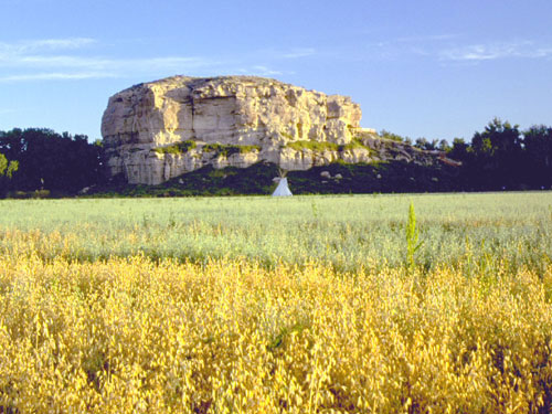
 Pompey's Pillar National Monument
Flora
See also: Monocotyledons of Montana, Coniferous plants of Montana, and Lichens of MontanaVegetation of the state includes lodgepole pine, ponderosa pine; douglas fir, larch, spruce; aspen, birch, red cedar, hemlock, ash, alder; rocky mountain maple and cottonwood trees. Forests cover approximately 25 percent of the state. Flowers native to Montana include asters, bitterroots, daisies, lupins, poppies, primroses, columbine, lilies, orchids, and dryads. Several species of sagebrush and cactus and many species of grasses are common. Many species of mushrooms and lichens are also found in the state.
Fauna
See also: Amphibians and Reptiles of Montana, List of birds of Montana, and Mammals of MontanaMontana is home to a diverse array of fauna that includes 15 amphibian, 85 fish, 110 mammal, 17 reptile and 420 bird species.[10] Additionally, there are over 10,000 invertebrate species, including 180 mollusks and 30 crustaceans.
Parks
See also: List of Montana state parksMontana contains Glacier National Park, "The Crown of the Continent"; and portions of Yellowstone National Park, including three of the Park's five entrances. Other federally recognized sites include the Little Bighorn National Monument, Bighorn Canyon National Recreation Area, Big Hole National Battlefield, Lewis and Clark Caverns, and the National Bison Range. Montana has ten National Forests and more than 20 National Wildlife Refuges. The Federal government administers 36,000,000 acres (150,000 km2). 275,000 acres (1,110 km2) are administered as state parks and forests.
 Quake Lake was created by a landslide during the 1959 Yellowstone Earthquake
Areas managed by the National Park Service include:[11]
- Big Hole National Battlefield near Wisdom
- Bighorn Canyon National Recreation Area near Fort Smith
- Glacier National Park
- Grant-Kohrs Ranch National Historic Site at Deer Lodge, Montana
- Lewis & Clark National Historic Trail
- Little Bighorn Battlefield National Monument near Crow Agency
- Nez Perce National Historical Park
- Yellowstone National Park
In March 2011, Montana ranked as a bottom-ten "Worst" state (tied with North Dakota and Texas) in the American State Litter Scorecard. Montana suffers from poor effectiveness and quality of its statewide public space cleanliness, due to overall state and related eradication standards and performance indicators.[12]
Indian reservations
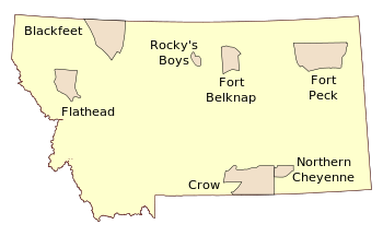 Seven Indian reservations in Montana (borders are not exact).
Seven American Indian reservations are located in Montana: Fort Peck Indian Reservation, Fort Belknap Indian Reservation, Northern Cheyenne Indian Reservation, Crow Indian Reservation, Rocky Boy's Indian Reservation, Blackfeet Indian Reservation, and the Flathead Indian Reservation.
Climate
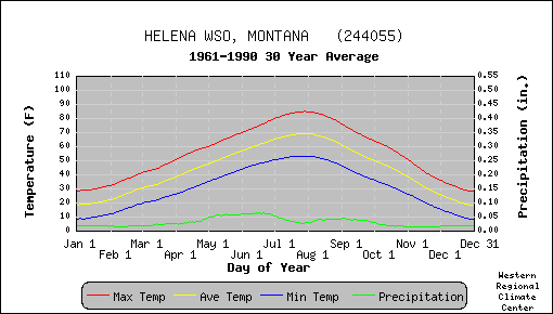
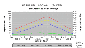 Temperature and precipitation for Montana's capital city, Helena
Montana is a large state with considerable variation in geography, and the climate is, therefore, equally varied. The state spans from 'below' the 45th parallel (the halfway line between the equator and the north pole) to the 49th parallel, and elevations range from under 2,000 feet (610 m) to nearly 13,000 feet (4,000 m) above sea level. The western half is mountainous, interrupted by numerous large valleys. Eastern Montana comprises plains and badlands, broken by hills and isolated mountain ranges, and has a semi-arid, continental climate (Köppen climate classification BSk). The Continental Divide runs north-south through the western mountainous half, and has a great effect on the climate. It restricts the flow of warmer air from the Pacific from moving east, and cooler, drier continental moving west. West of the divide, the climate is described as modified northern Pacific coast climate, with milder winters, cooler summers, less wind, and a longer growing season.[13] In the winter, valley fog and low clouds often form in the valleys west of the divide, but this is rarely seen in the east.[14]
Average daytime temperatures vary from 28 °F (−2 °C) in January to 84.5 °F (29.2 °C) in July.[15] The variation in geography leads to great variation in temperature. Hot weather occurs in the eastern plains on occasion, the highest observed being 117 °F (47 °C) at Glendive on July 20, 1893, and Medicine Lake on July 5, 1937. Throughout the state, summer nights are generally cool and pleasant. Temperatures decrease as altitude increases, and hot weather is unknown above 4,000 ft (1,200 m). Snowfall is not unknown in any month of the year in the central part of Montana, but is rare in July and August.[13]
 The Big Drift covering the Going-to-the-Sun Road in Glacier National Park as photographed on March 23, 2006.
The coldest temperature on record for Montana is also the coldest temperature for the entire continental U.S. On January 20, 1954, −70 °F (−57 °C) was recorded at a gold mining camp near Rogers Pass. Temperatures vary greatly on such cold nights, and Helena, 40 miles (64 km) to the southeast had a low of only −36 °F (−38 °C).[13] Winter cold spells last a week or so, and are usually the result of cold continental air coming south from Canada. The front is often well defined, causing a large temperature drop in a 24-hour period. Conversely, air flow from the southwest results in "Chinooks". These steady 25–50 mph (or more) winds can suddenly warm parts of Montana, especially areas just to the east of the mountains, where temperatures sometimes rise up to 50 °F (10 °C) – 60 °F (15 °C).[13]
Loma, Montana is the location of the most extreme recorded temperature change in a 24-hour period in the United States. On January 15, 1972, the temperature rose from −54 °F (−48 °C) to 49 °F (9 °C).[16]
 The Grinnell Glacier gets 105 inches (2,700 mm) of precipitation per year.
Average annual precipitation is 15 inches (380 mm), but great variations are seen. The mountain ranges block the moist Pacific air, holding moisture in the western valleys, and creating rain shadows to the east. Heron, in the west, receives the most precipitation, 34.70 inches (881 mm). On the eastern (leeward) side of a mountain range, the valleys are much drier; Lonepine averages 11.45 inches (291 mm), and Deer Lodge 11.00 inches (279 mm) of precipitation. The mountains themselves can receive over 100 inches (2,500 mm), for example the Grinnell Glacier in Glacier National Park gets 105 inches (2,700 mm).[14] Perhaps the driest is an area southwest of Belfry that averaged only 6.59 inches (167 mm) over a sixteen-year period. Most of the larger cities get 30 to 50 inches (760 to 1,300 mm) of snow each year. Mountain ranges themselves can accumulate 300 inches (7,600 mm) of snow during a winter. Heavy snowstorms may occur as early as September or as late as May, though most snow falls from November to March.[13]
The climate has become warmer in Montana and continues to do so.[17] The glaciers in Glacier National Park have receded and are predicted to melt away completely in a few decades.[18] Many Montana cities set heat records during July 2007, the hottest month ever recorded in Montana.[17][19] Winters are warmer, too, and have fewer cold spells. Previously these cold spells had killed off bark beetles which are now attacking the forests of western Montana.[20][21] The combination of warmer weather, attack by beetles, and mismanagement during past years has led to a substantial increase in the severity of forest fires in Montana.[17][21] According to a study done for the U.S. Environmental Protection Agency by the Harvard School of Engineering and Applied Science, portions of Montana will experience a 200% increase in area burned by wildland fires, and an 80% increase in air pollution from those fires.[22][23]
History
Main article: History of Montana Assiniboine family, Montana, 1890–91
Various indigenous peoples lived in the territory of the present-day state of Montana for thousands of years. Historic tribes encountered by Europeans and settlers from the United States included the Crow in the south-central area; the Cheyenne in the southeast; the Blackfeet, Assiniboine and Gros Ventres in the central and north-central area; and the Kootenai and Salish in the west. The smaller Pend d'Oreille and Kalispel tribes lived near Flathead Lake and the western mountains, respectively.
The land in Montana east of the continental divide was part of the Louisiana Purchase in 1803. Subsequent to the Lewis and Clark Expedition and after the finding of gold and copper (see the Copper Kings) in the area in the late 1850s, Montana became a United States territory (Montana Territory) on May 26, 1864. Prior to the creation of Montana Territory (1864–1889), various parts of what is now Montana were parts of Oregon Territory (1848–1859), Washington Territory (1853–1863), Idaho Territory (1863–1864), and Dakota Territory (1861–1864).
The Army established a series of posts in the late 1860s, including Fort Shaw, Camp Cooke on the Judith River and Fort C.F. Smith on the Bozeman Trail.
Montana was the scene of warfare as the Native Americans struggled to maintain control of their land. The last stand of U.S. Army Lieutenant Colonel George Armstrong Custer was fought near the present-day town of Hardin. Montana was also the location of the final battles of the Nez Perce Wars.
A series of major mining discoveries in the western third of the state starting in 1862 found gold, silver, copper lead, coal (and later oil) that attracted tens of thousands of miners to the area. The richest of all gold placer diggings was discovered at Alder Gulch, where the town of Virginia City was established. Other rich placer deposits were found at Last Chance Gulch, where the city of Helena now stands, Confederate Gulch, Silver Bow, Emigrant Gulch, and Cooke City. Gold output from 1862 through 1876 reached $144 million; silver then became even more important. The largest mining operations were in the city of Butte, which had important silver deposits and gigantic copper deposits.
Cattle ranching has been central to Montana's history and economy since the late-19th century. The Grant-Kohrs Ranch National Historic Site in Deer Lodge Valley is maintained as a link to the ranching style of the late 19th century. Operated by the National Park Service, it is a 1,900 acres (7.7 km2) working ranch.
The railroads arrived in the 1880s, including the Great Northern Railroad (1889) and its rival, the Northern Pacific Railroad (1883) from Minneapolis, and the Union Pacific Railroad (1881) from Denver. Montana railroading, with two transcontinentals to the Pacific coast and extensive operations to the mines, became a major industry, with centers in Billings and Havre. Montana became a state in 1889 in an omnibus package together with North Dakota, South Dakota and Washington.
The revised Homestead Act of 1909 greatly affected the settlement of Montana. This act expanded the amount of free land from 160 acres (0.6 km2) to 320 acres (1.3 km2) per family. Tens of thousands of inexperienced homesteaders arrived, lured by free land and high wheat prices, but they were unprepared for the climate, which usually had little rainfall and required special dry farming techniques. The droughts of 1917–1919 proved devastating, as many left, and half the banks in the state went bankrupt after providing mortgages that could not be repaid. The Great Depression caused further hardship for farmers and ranchers and miners, but the economy bounced back in the 1940s. The wheat farms in eastern Montana make the state a major producer; the wheat has a relatively high protein content and thus commands premium prices. After 1940 tourism became the state's third largest industry with Yellowstone and Glacier national parks as the largest tourist attractions.
Politics in the state has been competitive, with the Democrats usually holding an edge, thanks to the support among unionized miners and railroad workers. Large scale battles revolved around the giant Anaconda Copper company, based in Butte and controlled by Rockefeller interests, until it closed in the 1970s. Until 1959, the company owned five of the state's six largest newspapers.
Demographics
 Montana population density map
Historical populations Census Pop. %± 1870 20,595 — 1880 39,159 90.1% 1890 142,924 265.0% 1900 243,329 70.3% 1910 376,053 54.5% 1920 548,889 46.0% 1930 537,606 −2.1% 1940 559,456 4.1% 1950 591,024 5.6% 1960 674,767 14.2% 1970 694,409 2.9% 1980 786,690 13.3% 1990 799,065 1.6% 2000 902,195 12.9% 2010 989,415 9.7% Source: 1910–2010[24] Montana ranks 44th in population; only six states (Alaska, Wyoming, South Dakota, North Dakota, Vermont and Delaware) have fewer people. The 2010 census put Montana's population at 989,415 which is an increase of 87,220 people, or 9.7 percent, since the year 2000. Growth is mainly concentrated in Montana's seven largest counties, with the heaviest percentile growth in Gallatin County, which saw a 32%[25] increase in its population since 2000. The city seeing the largest percentile growth was Kalispell with 40.1%.[26] The city with the largest actual growth was Billings with an increase in population of 14,323 since 2000.[26]
According to the 2010 Census, 89.4% of the population was White (87.8% Non-Hispanic White Alone), 0.4% Black or African American, 6.3% American Indian and Alaska Native, 0.6% Asian, 0.1% Native Hawaiian and Other Pacific Islander, 0.6% from Some Other Race, and 2.5% from Two or More Races. Hispanics and Latinos of any race made up 2.9% of the population.[27]
The largest European ancestry groups in Montana are: German (29.3%), Irish (16.4%), English (13.1%), Norwegian (10%) and "American" (5.9%).[28]
According to 2010 U.S. Census the population of Montana's seven most populous areas is:[26][29]
Picture Place City population Metro Population Billings, Montana 104,700 158,050 Missoula, Montana 66,788 109,299 Great Falls, Montana 58,505 81,327 Bozeman, Montana 37,280 89,513 Butte, Montana 33,525 34,200[26][29] According to the 2000 U.S. Census, 94.8 percent of the population aged 5 and older speak English at home.[30]
The center of population of Montana is located in Meagher County, in the city of White Sulphur Springs.[31]
While German ancestry is the largest reported European-American ancestry in Montana as a whole, residents of Scandinavian ancestry are prevalent in some of the farming-dominated northern and eastern prairie regions, parallel to nearby regions of North Dakota and Minnesota. Irish and English are the second and third largest European ancestral groups in the state. There are also several predominantly Native American counties, mainly around each of the seven Indian reservations. The state has a larger Native American population (and percentage) than most US states. The seven reservations are actually made of more than twelve distinct Native American ethnolinguistic groups. The historically mining-oriented communities of western Montana such as Butte have a wider range of ethnic groups, and are particularly rich in European-American ethnicity; Finns, Eastern Europeans and especially Irish settlers left an indelible mark on the city, as well as people originally from British mining regions such as Cornwall, Devon, and Wales. The nearby city of Helena, also founded as a mining camp, had a similar mix in addition to a small Chinatown, and the Chinese in Montana, while a low percentage today, have historically been an important presence. Montanans who claim Filipino ancestry amount to almost 3,000, making them the largest Asian American group in the state.[32] Throughout the nineteenth century, many farmers of German, Scandinavian, Irish, Scots, and English roots settled in Montana. In addition, the Hutterites, originally from Central Europe, settled here, and today Montana is second only to South Dakota in U.S. Hutterite population with several colonies spread across the state. Many of Montana's historic logging communities originally attracted people of Scottish, Scandinavian, Slavic, English and Scots-Irish descent. Montana's Hispanic population is concentrated around the Billings area in south-central Montana, where many of Montana's Mexican-Americans have been in the state for generations. The highest density of African-Americans is located in Great Falls.
Demographics of Montana (csv) By race White Black AIAN* Asian NHPI* 2000 (total population) 92.79% 0.50% 7.36% 0.79% 0.12% 2000 (Hispanic only) 1.74% 0.05% 0.28% 0.04% 0.01% 2005 (total population) 92.52% 0.62% 7.47% 0.82% 0.11% 2005 (Hispanic only) 2.22% 0.07% 0.23% 0.03% 0.01% Growth 2000–05 (total population) 3.42% 28.09% 5.19% 7.11% -4.46% Growth 2000–05 (non-Hispanic only) 2.87% 25.58% 5.91% 8.07% -0.82% Growth 2000–05 (Hispanic only) 31.85% 52.36% -13.46% -13.52% -39.22% * AIAN is American Indian or Alaskan Native; NHPI is Native Hawaiian or Pacific Islander Religion
The religious affiliations of the people of Montana
- Christian: 82%
- Protestant: 55%
- Lutheran: 15%
- Methodist: 8%
- Baptist: 5%
- Presbyterian: 4%
- United Church of Christ: 2%
- Other Protestant or general Protestant: 21%
- Roman Catholic: 24%
- The Church of Jesus Christ of Latter-day Saints (Mormon): 5%
- Protestant: 55%
- Other Religions: <1%
- Non-Religious: 18%
As of the year 2000, the RCMS[33] reported that the three largest denominational groups in Montana are Catholic, Evangelical Protestant, and Mainline Protestant.
The largest denominations by number of adherents in 2000 were the Roman Catholic Church with 169,250; the Evangelical Lutheran Church in America with 50,287;[33] and as of Dec. 31, 2008 The Church of Jesus Christ of Latter-day Saints with 45,517.[34]
Economy
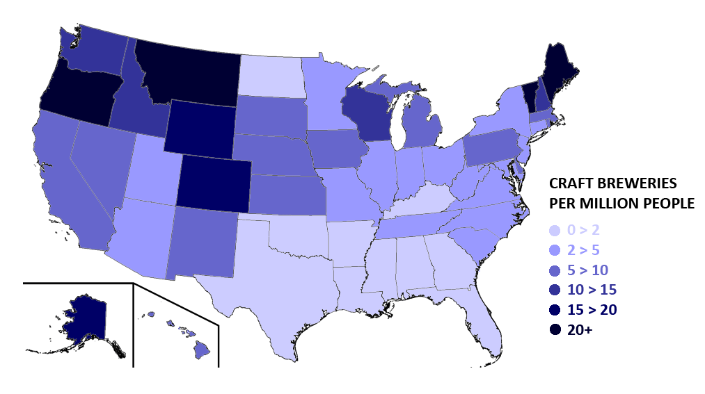
 Montana ranks 3rd nationally in craft breweries per capita.
 First Interstate Center in downtown Billings, the tallest building in Montana
The Bureau of Economic Analysis estimates that Montana's total state product in 2003 was $26 billion. Per capita personal income in 2003 was $25,406, 47th in the nation. However, this number is rapidly increasing.
Montana is a relative hub of beer microbrewing, ranking third in the nation in number of craft breweries per capita.[35] There are significant industries for lumber and mineral extraction; the state's resources include gold, coal, silver, talc, and vermiculite. Ecotaxes on resource extraction are numerous. A 1974 state severance tax on coal (which varied from 20 to 30 percent) was upheld by the Supreme Court of the United States in Commonwealth Edison Co. v. Montana, 453 U.S. 609 (1981).
Tourism is also important to the economy with millions of visitors a year to Glacier National Park, Flathead Lake, the Missouri River headwaters, the site of the Battle of Little Bighorn and three of the five entrances to Yellowstone National Park.
Montana's personal income tax contains 7 brackets, with rates ranging from 1% to 6.9%. Montana has no sales tax. In Montana, household goods are exempt from property taxes. However, property taxes are assessed on livestock, farm machinery, heavy equipment, automobiles, trucks, and business equipment. The amount of property tax owed is not determined solely by the property's value. The property's value is multiplied by a tax rate, set by the Montana Legislature, to determine its taxable value. The taxable value is then multiplied by the mill levy established by various taxing jurisdictions—city and county government, school districts and others.
As of January 2010, the state's unemployment rate is 6.8%.[36]
Transportation
See also: List of Montana railroads, List of Montana numbered highways, and List of airports in MontanaRailroads have been an important method of transportation in Montana since the 1880s. Historically, the state was traversed by the main lines of three east-west transcontinental routes: the Milwaukee Road, the Great Northern, and the Northern Pacific. Today, the BNSF Railway is the state's largest railroad, its main transcontinental route incorporating the former Great Northern main line across the state. Montana RailLink, a privately-held Class II railroad, operates former Northern Pacific trackage in western Montana.
In addition, Amtrak's Empire Builder train runs through the north of the state, stopping in the following towns: Libby, Whitefish, West Glacier, Essex, East Glacier Park, Browning, Cut Bank, Shelby, Havre, Malta, Glasgow, and Wolf Point.
Billings Logan International Airport is the largest and busiest airport within a four state region (Montana, Wyoming, North and South Dakota) both in passenger boardings and air cargo.[38] Montana's other major Airports include Gallatin Field Airport, Missoula International Airport, Great Falls International Airport, Glacier Park International Airport, Helena Regional Airport, Bert Mooney Airport and Yellowstone Airport. Eight smaller communities have airports designated for commercial service under the Essential Air Service program.
Historically, the primary east-west highway route across Montana was U.S. Route 10, which connected the major cities in the southern half of the state. Still the state's most important east-west travel corridor, the route is today served by Interstate 90 and Interstate 94. U.S. Routes 2 and 12 and Montana Highway 200 also traverse the entire state from east to west.
Montana's only north-south Interstate Highway is Interstate 15. Other major north-south highways include U.S. Routes 87, 89, 93 and 191. Interstate 25 terminates into I-90 just south of the Montana border in Wyoming.
Montana and South Dakota are the only states to share a land border which is not traversed by a paved road.[39]
In March 2011, Montana ranked as a bottom-ten "Worst" state (tied with North Dakota and Texas) in the American State Litter Scorecard. Montana suffers from poor effectiveness and quality of its statewide public space cleanliness, due to overall state and related eradication standards and performance indicators.[40] Also that year, Montana ranked among the five deadliest states for debris/litter–caused vehicle accidents per total number of registered vehicles and population size. Figures derived from[41] NHTSA show at least nine persons in Montana were killed each year in motor vehicle collisions with non-fixed objects, including debris, dumped litter, animals and their carcasses.
Law and government
See also: List of Montana GovernorsThe current Governor is Brian Schweitzer (Democrat) who was sworn in on January 3, 2005. Montana's two U.S. senators are Max Baucus (Democrat) and Jon Tester (Democrat). The state's congressional representative is Denny Rehberg (Republican).
Montana in 1916 became the first state to elect a woman to Congress (Jeannette Rankin) (Republican) and was one of the first states to give women voting rights (see suffrage).
Ethnicity
Apart from the sizable American Indian population, nearly 90% of its residents are of European descent, with a large numbers of German, Irish, British, Slavic, Italian, and Scandinavian immigrants arriving 1890–1910. About 2000–3000 Chinese miners were in Montana by 1870, and 2500 in 1890. They were strongly opposed by labor unions, and public opinion grew increasingly negative in the 1890s and nearly half left the state by 1900.[42]
Politics
Historically, Montana is a swing state of cross-ticket voters who tend to fill elected offices with individuals from both parties. Through the mid-20th century, the state had a tradition of "sending the liberals to Washington and the conservatives to Helena." However, beginning in the 1980s, the pattern flipped, with voters more likely to elect conservatives to federal offices. There have also been long-term shifts of party control. During the 1970s, the state was dominated by the Democratic Party, with Democratic governors for a 20-year period, and a Democratic majority of both the national congressional delegation and during many sessions of the state legislature. This pattern shifted, beginning with the 1988 election, when Montana elected a Republican governor and sent a Republican to the U.S. Senate for the first time since the 1940s. This shift continued with the reapportionment of the state's legislative districts that took effect in 1994, when the Republican Party took control of both chambers of the state legislature, consolidating a Republican party dominance that lasted until 2004.
In presidential elections, Montana was long classified as a swing state, though in recent years, Montana has been classified as a Republican-leaning state, as the state supported Republican presidential candidates in every election from 1996 to the present. The state last supported a Democrat for president in 1992, when Bill Clinton won a plurality victory. Overall, since 1889 the state has voted for Democratic governors 60 percent of the time and Democratic presidents 40 percent of the time, with these numbers being 40/60 for Republican candidates. In the 2008 presidential election, Montana was considered a swing state and was ultimately won by Republican John McCain, albeit by a narrow margin of two percent.[43]
However, at the state level, the pattern of split ticket voting and divided government holds. Democrats currently hold both U.S. Senate seats, as well as four of the five statewide offices (Governor, Attorney General, Secretary of State and State Auditor). The Legislative branch had split party control between the house and senate most years between 2004 and 2010, when the mid-term elections returned both branches to Republican control. The state Senate is, as of 2010, controlled by the Republicans 28 to 22, and the State House of Representatives at 68 to 32.
Montana is an Alcoholic beverage control state.
Further information: Political party strength in MontanaImportant cities and towns
See also: List of cities and towns in Montana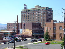 Butte
ButteThe seven major cities in Montana are:
Some of the major towns in Montana are:
Counties
Main article: List of counties in MontanaThe state of Montana has 56 counties.
Education
Colleges and universities
The state-funded Montana University System consists of:
- Flathead Valley Community College
- Dawson Community College
- Miles Community College
- Montana State University – Bozeman
- Montana State University Billings
- Montana State University – Northern—Havre
- Montana State University College of Technology – Great Falls
- University of Montana – Missoula
- Montana Tech of the University of Montana—Butte
- University of Montana Western—Dillon
- University of Montana – Helena College of Technology
Major Tribal Colleges in Montana include:
- Fort Peck Community College or Ft. Peck Community College
- Little Big Horn College
- Salish Kootenai College
- Stone Child College
- Blackfeet Community College- Browning
There are three small private colleges based in Montana, in addition to branch campuses of out-of-state schools:
Sports
Professional sports
There are no major league sports franchises in Montana due to the state's relatively small and dispersed population, but a number of minor league teams play in the state. Baseball is the minor-league sport with the longest heritage in the state, and Montana is currently home to four Minor League baseball teams, all members of the Pioneer Baseball League:
The Missoula Phoenix and the Great Falls Gladiators are semi-pro football teams in the Rocky Mountain Football League (RMFL).
Collegiate and amateur sports
All of Montana's four-year colleges and universities field a variety of intercollegiate sports teams. The two largest schools, the University of Montana and Montana State University, are members of the Big Sky Conference and have enjoyed a strong athletic rivalry since the early twentieth century. Most of the smaller four-year schools in the state belong to the Frontier Conference.
Football and basketball are the two most popular sports at the high school level. Montana is one of the few states where the smallest high schools participate in six-man football leagues.
Numerous other sports are played at the club and amateur level, including softball, rugby, and soccer. In 2011, Big Sky Little League won the Northwest Region, advancing to the Little League World Series in South Williamsport, PA for the first time in state history.
From 1988–2010, the Montana High School All Class Wrestling Tournament was held in Billings at MetraPark. This event remains one of the most popular high school events each year in Montana. The 2011 event was relocated to three different cities due to a freak tornado that tore the roof of of the MetraPark building on June 20, 2011.[45] The MetraPark has been repaired and expects to host the all class tournament again.
There are six junior hockey teams in Montana, all affiliated with the American West Hockey League:
- Billings Bulls
- Bozeman Icedogs
- Butte Roughriders
- Great Falls Americans
- Helena Bighorns
- Missoula Maulers
Ft. Shaw
In 1904 a group of young Native American women, after playing undefeated during their last season, went to the Louisiana Purchase Exposition held in St. Louis and defeated all challenging teams and were declared to be world champions. For this they received a large silver trophy with the inscription "World's Fair – St. Louis, 1904 – Basket Ball – Won by Fort Shaw Team".[46]
Montana in popular culture
- The protagonist in Ernest Hemingway's For Whom the Bell Tolls (1940), Robert Jordan, is a native Montanan. The 1943 film adaptation starred Gary Cooper, a native Montanan himself. Hemingway traveled to Montana extensively, and much of his family still lives in the state.
- In Larry McMurtry's 1985 Pulitzer Prize-winning novel Lonesome Dove, the protagonists drive a herd of cattle from Texas to Montana, with the latter state being described as "a cattleman's paradise." The 1989 TV miniseries of the same name, Lonesome Dove, was filmed partly in the state.
- The 1989 film Always is a romantic drama directed by Steven Spielberg, and starring Richard Dreyfuss, Holly Hunter, John Goodman and Brad Johnson. This is also Audrey Hepburn's final film appearance.
- the 1990 film Silence of the Lambs with Jodie Foster, Anthony Hopkins, and Scott Glenn, Clarice Starling (Foster) lived in Montana before joining the FBI.
- The 1992 film A River Runs Through It takes place in and around Missoula, Montana, although much of the filming was done on the Gallatin and Madison rivers south of Bozeman. The film is about the Prohibition era of the 1920s. It stars Brad Pitt, Craig Sheffer and Tom Skerritt. Directed by Robert Redford.
- The 1994 film The River Wild is a thriller directed by Curtis Hanson and starring Meryl Streep, Kevin Bacon, David Strathairn, John C. Reilly, and Joseph Mazzello. The story involves a family on a whitewater rafting trip who encounter violent criminals.
- The 1994 film Legends of the Fall which stars Brad Pitt, Anthony Hopkins and Aidan Quinn is set (though was not filmed) in Montana, including Helena. It is about a family's struggle to live through World War I, the Prohibition 1920s and the 1930s. Directed by Edward Zwick.
- In the 1996 movie Star Trek: First Contact, Montana is the location of the fictitious first contact between humans and an alien race, the Vulcans. Star Trek producer Brannon Braga is originally from Bozeman, Montana. However, no Montana locations were used in the shooting of the film. Other Montana references occasionally dot various Star Trek films and television episodes, including one starship named the "Bozeman".
- "Montana"is the final track off of Frank Zappa's 1973 album Over-Nite Sensation.
- In the TV series The Big Bang Theory, Sheldon moves to Bozeman, Montana due to its low criminal rate, after being robbed in Pasadena. He returns immediately after being robbed again at Bozeman's bus station upon arrival.
Miscellaneous topics
- The planned battleship USS Montana was named in honor of the state. However, the battleship was never completed, making Montana the only one of the 48 states during World War II not to have a battleship named after it. Additionally, Alaska and Hawaii have both had nuclear submarines named after them. As such Montana is the only state in the union without a modern naval ship named in its honor. However, in August 2007 Senator Jon Tester made a request to the Navy that a submarine be christened USS Montana.[47]
- Montana has the largest grizzly bear population in the lower 48 states.
- Montana's triple divide allows water to flow into three oceans: the Pacific Ocean, the Atlantic Ocean (Gulf of Mexico), and the Arctic Ocean (Hudson Bay). This phenomenon occurs at Triple Divide Peak in Glacier National Park.
- In 1888, Helena (the current state capital) had more millionaires per capita than any other city in the world.
State symbols
 Montana's state quarter, released in 2007.
- State flower: Bitterroot (Lewisia rediviva), since 1895
- State tree: Ponderosa Pine, since 1949
- State animal: Grizzly Bear (Ursus arctos horribilis), since 1862
- State bird: Western Meadowlark (Sturnella neglecta), since 1931
- State fish: Cutthroat trout Oncorhynchus clarkii, since 1977[48]
- State Song: "Montana", since 1945
- State Ballad: "Montana Melody", since 1983
- State Gemstones: Yogo sapphire & Agate
- State Fossil: Maiasaur ("Duck-billed Dinosaur") (Maiasaura peeblesorum), since 1985
- State Butterfly: Mourning cloak (Nymphalis antiopa), since 2001
- State Grass: Bluebunch wheatgrass, since 1973
- State Motto: "Oro y Plata" (Spanish: Gold and Silver)
Ski areas
 The Big Sky Resort
 The Palisades area on the north end of the ski area at Red Lodge Mountain Resort
Montana has several ski areas including:
- Bear Paw Ski Bowl near Havre, Montana
- Big Sky Resort near Big Sky, Montana
- Blacktail near Lakeside
- Bridger Bowl Ski Area near Bozeman
- Discovery Basin near Philipsburg
- Great Divide near Helena, Montana
- Lookout Pass near St. Regis, Montana
- Lost Trail near Darby, Montana
- Maverick Mountain near Dillon, Montana
- Moonlight Basin near Big Sky, Montana
- Red Lodge Mountain near Red Lodge
- Showdown Ski Area near White Sulphur Springs, Montana
- Snowbowl Ski Area near Missoula
- Teton Pass Ski Area near Choteau
- Turner Mountain Ski Resort near Libby
- Whitefish Mountain Resort near Whitefish
See also
- Outline of Montana
- Index of Montana-related articles
- List of National Register of Historic Places in Montana
- List of people from Montana
- List of places in Montana
- Missouri River
- Rocky Mountains
- US state
References
- ^ "Granite Peak". NGS data sheet. U.S. National Geodetic Survey. http://www.ngs.noaa.gov/cgi-bin/ds_mark.prl?PidBox=QW0616. Retrieved October 24, 2011.
- ^ a b "Elevations and Distances in the United States". United States Geological Survey. 2001. http://egsc.usgs.gov/isb/pubs/booklets/elvadist/elvadist.html. Retrieved October 24, 2011.
- ^ a b Elevation adjusted to North American Vertical Datum of 1988.
- ^ "Montana Code Annotated 2009 – Title 1, chapter 1, Part 5 "State Symbols – Official Designations"". State of Montana. http://data.opi.mt.gov/bills/mca_toc/1_1_5.htm. Retrieved July 21, 2011.
- ^ Shovers, Brian (2003). "Montana Episodes". Montana Department of Tourism. http://travel.mt.gov/history/Montana_the_Magazine_of_Western_History/Spring03/treasurestate.htm. Retrieved August 28, 2011.
- ^ Robbins, Jim (August 17, 2008). "In Montana, a Popular Expression Is Taken Off the Endangered List". New York Times. http://www.nytimes.com/2008/08/18/us/18trademark.html?em. Retrieved August 28, 2011.
- ^ "Montana's Population Projections: 1995–2025". United States Census Bureau. http://www.census.gov/population/projections/state/9525rank/mtprsrel.txt. Retrieved July 21, 2011.
- ^ "Montana". United States Department of Labor – Bureau of Labor Statistics. http://www.bls.gov/eag/eag.mt.htm. Retrieved July 21, 2011.
- ^ Thackeray, Lorna (October 17, 2009). "National-park visitors boost Montana’s tourism stats". Billings Gazette. http://billingsgazette.com/news/state-and-regional/montana/article_a9e53dca-badc-11de-9615-001cc4c03286.html. Retrieved July 21, 2011.
- ^ "Wild Things-Species of Montana". Montana Department of Fish, Wildlife, and Parks. http://fwp.mt.gov/wildthings/. Retrieved November 30, 2010.
- ^ "Montana". National Park Service. http://www.nps.gov/state/mt/index.htm. Retrieved October 6, 2010.
- ^ S. Spacek, 2011 American State Litter Scorecard: New Rankings for an Increasingly Environmentally Concerned Populous.
- ^ a b c d e "Western Regional Climate Center "Climate of Montana"". Desert Research Institute. Accessed October 6, 2010. http://www.wrcc.dri.edu/narratives/MONTANA.htm.
- ^ a b "Climate in Montana". Animal Range and Sciences, Extension Service, Montana State University. Accessed October 6, 2010. http://www.animalrangeextension.montana.edu/articles/forage/MIPMH-chptr-1.htm#Temperature.
- ^ "Montana Facts". Visit MT.com. Accessed October 6, 2010. http://www.visitmt.com/virtualvisitor/faq.htm.
- ^ Andrew H. Horvitz, et al. A National Temperature Record at Loma, Montana, National Weather Service, 2002. Retrieved November 2, 2008.
- ^ a b c "UM climate expert says triple-digit Julys will be norm". Billings Gazette. August 27, 2007. http://www.billingsgazette.net/articles/2007/08/27/news/state/24-fry.txt.
- ^ "Glacier Monitoring Research". Monitoring and Assessing Glacier Changes and Their Associated Hydrologic and Ecologic Effects in Glacier National Park. U.S. Geological Survey. http://www.nrmsc.usgs.gov/research/glaciers.htm. Retrieved June 27, 2007.
- ^ NOAA "Climate of 2007 – July in Historical Perspective". National Climatic Data Center. August 15, 2007. http://www.ncdc.noaa.gov/oa/climate/research/2007/jul/jul07.html NOAA.
- ^ "Beetles shaping Montana's forest lands". The Missoulian. July 31, 2005. http://www.missoulian.com/articles/2005/07/31/news/mtregional/news02.tx.
- ^ a b "Forest Service finds varied beetle activity". The Missoulan. February 14, 2010. http://www.missoulian.com/articles/2007/02/14/news/mtregional/news07.txt.
- ^ "Forecast: More air pollution, Study predicts global warming will increase fires in Northern Rockies". Billings Gazette. July 29, 2009. http://www.billingsgazette.com/news/state-and-regional/montana/article_d3d32b14-7cc6-11de-b4e3-001cc4c03286.html.
- ^ "Impacts of climate change from 2000 to 2050 on wildfire activity and carbonaceous aerosol concentrations in the western United States". Journal of Geophysical Research. http://acmg.seas.harvard.edu/publications/spracklen_2008.pdf.
- ^ 2010.census.gov
- ^ 2010.census.gov
- ^ a b c d bloximages.chicago2.vip.townnews.com
- ^ factfinder2.census.gov
- ^ factfinder2.census.gov
- ^ a b bloximages.chicago2.vip.townnews.com
- ^ Language Map Data Center
- ^ "Population and Population Centers by State: 2000". U.S. Census Bureau. 2000. http://www.census.gov/geo/www/cenpop/statecenters.txt. Retrieved May 7, 2008.
- ^ http://factfinder2.census.gov/faces/tableservices/jsf/pages/productview.xhtml?fpt=table
- ^ a b "State Membership Reports". thearda.com. http://www.thearda.com/mapsReports/reports/state/30_2000.asp. Retrieved June 15, 2010.
- ^ Deseret News 2009 Church Almanac of The Church of Jesus Christ of Latter-Day Saints
- ^ Craft Brewing Industry Statistics
- ^ "Local Area Unemployment Statistics". bls.gov. http://www.bls.gov/lau/.
- ^ Pitt, John (2008). USA by Rail. Bradt Travel Guides. p. 100. ISBN 1841622559. http://books.google.com/?id=zaqJV1s4PMsC.
- ^ faa.gov
- ^ Official State of Montana Highway Map
- ^ S. Spacek, 2011 American State Litter Scorecard.
- ^ National Highway Traffic Safety Administration
- ^ Patrick F. Morris, Anaconda, Montana: copper smelting boom town on the western frontier (1997) p 113-24
- ^ 2008 Election Results, CNN
- ^ "Table 1: Annual Estimates of the Population for Counties of Montana: April 1, 2000 to July 1, 2008" (CSV). 2008 Population Estimates. U.S. Census Bureau, Population Division. October 3, 2009. http://ceic.mt.gov/Demog/estimate/pop/County/CO-EST2008-07-01.htm. Retrieved January 9, 2007.
- ^ youtube.com
- ^ Full Court Quest. Linda Peavy and Ursula Smith. Norman, OK: University of Oklahoma Press: 2008.
- ^ Press Release Detail
- ^ "Montana Code Annotated-1-1-507. State fish". http://data.opi.mt.gov/bills/mca/1/1/1-1-507.htm. Retrieved November 29, 2010.
Further reading
Main article: Bibliography of Montana history- Axline, Jon, et al. Still Speaking Ill of the Dead: More Jerks in Montana History. Falcon Press, 2005. ISBN 1-58592-032-0
- Bennion, Jon. Big Sky Politics. Five Valleys Publishing, April 2004. ISBN 1-888550-13-9
- Doig, Ivan, Dancing at the Rascal Fair. Scribner: 1987. ISBN 0-689-11764-7.
- Doig, Ivan, English Creek. Peter Smith Publisher Inc: 1992. ISBN 0-8446-6608-4.
- Howard, Joseph Kinsey. Montana: High, Wide, and Handsome. Bison Books: 2003. ISBN 0-8032-7339-8.
- Howard, Joseph Kinsey. Montana Margins: A State Anthology. Yale University Press,: 1946. ISBN 0-8369-2652-8.
- Kittredge, William. The Last Best Place: A Montana Anthology. (From the back cover: "...over 230 stories, poems, reminiscences, and reports written by 140 men and women. The book is divided into eight sections with introductory essays by William Bevis, Mary Clearman Blew, William Kittredge, William Lang, Richard Roeder, Annick Smith, and James Welch.") University of Washington Press: 1990. 1158 pages. ISBN 0-295-96974-1.
- Lopach, James. We the People of Montana: The Workings of a Popular Government. Falcon Press, 1983 ISBN 0-87842-159-9
- MacLean, Norman, A River Runs Through It. University of Chicago Press: 1976. ISBN 0-226-50060-8.
- MacLean, Norman, Young Men and Fire. University of Chicago Press: 1992. ISBN 0-226-50061-6.
- Malone, Michael P., Richard B. Roeder and William L. Lang. Montana: A History of Two Centuries. University of Washington: 1991. ISBN 0-295-97129-0.
- Toole, K. Ross. Montana: An Uncommon Land. University of Oklahoma Press: 1984. ISBN 0-8061-1890-3.
- Walter, Dave, et al. Speaking Ill of the Dead: Jerks in Montana History. Falcon Press, 2000. ISBN 1-58592-032-0
- Walker, Mildred. Winter Wheat. Harcourt: 1967. ISBN 0-15-197223-0.
External links
- State of Montana Website
- Official State Travel Information Site
- Montana at the Open Directory Project
- Montana energy data & statistics – From the U.S. Department of Energy
- Montana Historical Society
- Everything you need to know about Montana.
- Montana History
- Montana State Capitol Information
- Montana state facts from the U.S. Department of Agriculture
- Census of Montana
- List of searchable databases produced by Montana state agencies hosted by the American Library Association Government Documents Roundtable.
- USGS real-time, geographic, and other scientific resources of Montana
- Famous and infamous Montanans
- Fly Fishing in Montana
 OpenStreetMap has geographic data related to Montana
Coordinates: 47°N 110°W / 47°N 110°WPreceded by
South DakotaList of U.S. states by date of statehood
Admitted on November 8, 1889 (41st)Succeeded by
Washington
 British Columbia
 Canada
 Alberta
 Saskatchewan
 Idaho
Idaho
 North Dakota
 Montana: Outline • Index

 Wyoming
 South Dakota
 State of Montana
Helena (capital) Topics Index · History · Governors · People · Geography · State Government · Delegations · Visitor Attractions
Society Crime · Demographics · Economy · Education · Politics
Regions The Flathead · Glacier National Park · Regional designations of Montana · Western Montana · Yellowstone
Largest cities Counties Beaverhead · Big Horn · Blaine · Broadwater · Carbon · Carter · Cascade · Chouteau · Custer · Daniels · Dawson · Deer Lodge · Fallon · Fergus · Flathead · Gallatin · Garfield · Glacier · Golden Valley · Granite · Hill · Jefferson · Judith Basin · Lake · Lewis and Clark · Liberty · Lincoln · Madison · McCone · Meagher · Mineral · Missoula · Musselshell · Park · Petroleum · Phillips · Pondera · Powder River · Powell · Prairie · Ravalli · Richland · Roosevelt · Rosebud · Sanders · Sheridan · Silver Bow · Stillwater · Sweet Grass · Teton · Toole · Treasure · Valley · Wheatland · Wibaux · Yellowstone
Main list · Athletes · Congressional Delegations · Entertainers · Governors · US Senators · US Representatives · State Senators · State Representatives ·United States (Outline) History Pre-Columbian era · Colonial era (Thirteen Colonies · Colonial American military history) · American Revolution (War) · Federalist Era · War of 1812 · Territorial acquisitions · Territorial evolution · Mexican–American War · Civil War · Reconstruction era · Indian Wars · Gilded Age · African-American Civil Rights Movement (1896–1954) · Spanish–American War · Imperialism · World War I · Roaring Twenties · Great Depression · World War II (Home front) · Cold War · Korean War · Space Race · African-American Civil Rights Movement (1955–1968) · Feminist Movement · Vietnam War · Post-Cold War (1991–present) · War on Terror (War in Afghanistan · Iraq War) · Timeline of modern American conservatismTopicsDemographic · Discoveries · Economic (Debt Ceiling) · Inventions (before 1890 · 1890–1945 · 1946–1991 · after 1991) · Military · Postal · Technological and industrialFederal
governmentLegislature - Congress
Senate
· Vice President
· President pro tem
House of Representatives
· Speaker
Judiciary - Supreme Court
Federal courts
Courts of appeal
District courtsExecutive - President
Executive Office
Cabinet / Executive departments
Civil service
Independent agencies
Law enforcement
Public policy
Intelligence
Central Intelligence Agency
Defense Intelligence Agency
National Security Agency
Federal Bureau of InvestigationPolitics Divisions · Elections (Electoral College) · Foreign policy · Foreign relations · Ideologies · Local governments · Parties (Democratic Party · Republican Party · Third parties) · Political status of Puerto Rico · Red states and blue states · Scandals · State governments · Uncle SamGeography Cities, towns, and villages · Counties · Extreme points · Islands · Mountains (Peaks · Appalachian · Rocky) · National Park System · Regions (Great Plains · Mid-Atlantic · Midwestern · New England · Northwestern · Southern · Southwestern · Pacific · Western) · Rivers (Colorado · Columbia · Mississippi · Missouri · Ohio · Rio Grande) · States · Territory · Water supply and sanitationEconomy Agriculture · Banking · Communications · Companies · Dollar · Energy · Federal Budget · Federal Reserve System · Financial position · Insurance · Mining · Public debt · Taxation · Tourism · Trade · Transportation · Wall StreetSociety TopicsCrime · Demographics · Education · Family structure · Health care · Health insurance · Incarceration · Languages (American English · Spanish · French) · Media · People · Public holidays · Religion · SportsArchitecture · Art · Cinema · Cuisine · Dance · Fashion · Flag · Folklore · Literature · Music · Philosophy · Radio · Television · TheaterIssues Book ·
  Category ·
  Portal ·
  WikiProjectCategories:
- Montana
- States of the United States
- States and territories established in 1889


Wikimedia Foundation. 2010.