- Torrance, California
-
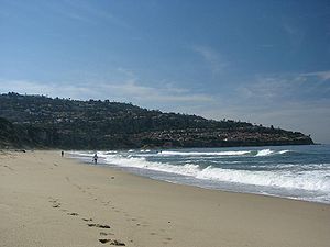
City of Torrance — City — View of Torrance Beach with neighboring Palos Verdes in the background

Flag
SealNickname(s): T Town Motto: A Balanced City Location of Torrance in the County of Los Angeles
Coordinates: 33°50′5″N 118°20′29″W / 33.83472°N 118.34139°WCoordinates: 33°50′5″N 118°20′29″W / 33.83472°N 118.34139°W Country United States State California County Los Angeles Incorporated May 12, 1921 Government – Type Council-Manager – City Council Mayor Frank Scotto
Gene Barnett
Tom Brewer
Pat Furey
Cliff Numark
Susan Rhilinger
Bill Sutherland– City Treasurer Dana Cortez – City Clerk Sue Herbers Area[1] – Total 20.553 sq mi (53.233 km2) – Land 20.478 sq mi (53.038 km2) – Water 0.075 sq mi (0.195 km2) 0.37% Elevation 89 ft (27 m) Population (2010) – Total 145,438 – Rank 8th in Los Angeles County
36th in California
166th in the United States– Density 7,076.1/sq mi (2,732.1/km2) Time zone PST (UTC-8) – Summer (DST) PDT (UTC−7) ZIP codes 90501-90510 Area code(s) 310 FIPS code 06-80000 GNIS feature ID 1652802 Website http://www.TorranceCA.gov Torrance is a city incorporated in 1921 and located in the South Bay (southwestern) region of Los Angeles County, California, United States. Torrance has 1.5 miles (2.4 km) of shore-front beaches on the Pacific Ocean, quieter and less well-known by tourists than others on the Santa Monica Bay, such as those of neighboring Redondo Beach and Manhattan Beach. Torrance enjoys a moderate year-round climate with warm temperatures, sea breezes, low humidity and an average rainfall of 12.55 inches per year.[2]
The Torrance population was 145,438 at the 2010 census. This residential and light-high-tech industries city has 90,000 street trees and 30 city parks.[2] Torrance is the birthplace of the AYSO – American Youth Soccer Organization.
Contents
History
Torrance was originally part of the Tongva Native American homeland for thousands of years. In 1784 the Spanish land grant for Rancho San Pedro, in the upper Las Californias Province of New Spain and encompassing present day Torrance, was issued to Juan Jose Dominguez by King Carlos III—the Spanish Empire.[3][4] It was later divided in 1846 with Governor Pío Pico granting Rancho de los Palos Verdes to José Loreto and Juan Capistrano Sepulveda, in the Alta California territory of independent Mexico.[5][6]
In the early 1900s, real estate developer Jared Sidney Torrance and other investors saw the value of creating a mixed industrial-residential community south of Los Angeles. They purchased part of an old Spanish land grant and hired landscape architect Frederick Law Olmsted, Jr. to design a new planned community.[7] The resulting town was founded in October 1912 and named after Torrance. The city of Torrance was formally incorporated in May 1921.[8] The first residential avenue created in Torrance was Gramercy and the second avenue was Andreo. Many of the house on these avenues turn 100 years of age in 2012. Both avenues are located in the area referred to as Old Town Torrance. This section of Torrance is under review to be classified as a historical district.[9] Some of the early civic and residential buildings were designed by the renowned and innovative Southern California architect Irving Gill, in his distinctive combining of Mission Revival and early Modernist architecture.[10]
Historically the El Nido neighborhood was home to many European immigrants, such as originally Dutch, German, Greek, Italian and Portuguese people; soon joined by Mexican-American and Hispanic and Latino immigrants; employed in the growing early 20th century agriculture, petroleum, and manufacturing industries, such as the fish canneries.[citation needed]
Rapid new growth in Torrance began after World War II as wartime industries transformed into Post-war Aerospace manufacturers and related technology industries. Large housing developments were built in the 1950s and 1960s to accommodate the new population. Torrance moved on after the closure of some aerospace development and oil refinery plants in the 1990s statewide recession.[citation needed]
Torrance survived the deindustrialization, regional economic slowdowns and national recessions in the 1970s to 2000s. Large-scale Asian immigration in the past couple of decades has transformed Torrance into a diverse and multicultural city.
Geography
Torrance is located at 33°50′5″N 118°20′29″W / 33.83472°N 118.34139°W (33.834815, −118.341330).[11]. The United States Census Bureau boundaries show the city has a total area of 20.5 square miles (53 km2), virtually all land.
Description
Torrance is a coastal community in southwestern Los Angeles County, as seen on the map above, sharing the climate and geographical features common to the Greater Los Angeles area. Its boundaries are: Redondo Beach Boulevard and the cities of Lawndale and Gardena to the north; Western Avenue and the Harbor Gateway neighborhood of Los Angeles to the east; the Palos Verdes Hills with the cities of Lomita, Rolling Hills Estates and Palos Verdes Estates on the south; and the Pacific Ocean and city of Redondo Beach to the west.[12]
Torrance Beach lies between Redondo Beach and Malaga Cove on the Santa Monica Bay.[13] The region shared by Torrance and Redondo Beaches are often called "RAT Beach" (short for "Right After Torrance" Beach or "Redondo and Torrance Beach").[12]
One of the country's few urban wetlands, the Madrona Marsh, is found in Torrance to explore. It is a nature preserve, on land once set for oil production and saved development, with restoration projects enhancing the vital habitat for birds, wildlife, and native plants.[14][15] A Nature center provides activities, information, and classes for school children and visitors of all ages.[16]
Residents of an unincorporated area to the east of Harbor Gateway abutting the city of Carson are allowed to use "Torrance" in their addresses by the USPS.
Torrance Attractions
 The Torrance Armed Forces Day Parade, with a USMC unit.
The Del Amo Fashion Center, at 2.5 million square feet (232,000 m²), is one of the largest malls in the United States. Estimates vary between the second largest (after the Mall of America) and the fourth largest, depending on the measurements used. The current mall was created when Del Amo Center, built in 1958, merged with Del Amo Fashion Square, built in 1970. Once located on opposite sides of Carson Street, a gigantic expansion of the mall spanning Carson Street joined the two centers by 1982, making it the longest mall in the world at the time. In 2005, the east end of the original mall north of Carson Street was demolished to make way for a new open-air shopping center, opened in mid-September, 2006. The new center features upscale clothiers Anthropologie, Coach, H&M and Urban Outfitters as well as the restaurant P.F. Chang's. The housewares retail giant Crate & Barrel opened in what was once a section of the mall parking lot in Spring 2007. Torrance also borders the South Bay Galleria, which resides in Redondo Beach.
The Armed Forces Day Parade in Torrance, which was first produced in 1960, is the longest running military parade sponsored by a city. It is held annually on Armed Forces Day, and runs down Torrance Boulevard. The parade features military vehicles, school bands, and prominent community members.[17]
The Torrance Cultural Arts Center hosts cultural events year-round. Regular performances are provided by the groups belonging to the Torrance Performing Arts Consortium, including The Aerospace Players, Los Cancioneros Master Chorale, South Bay Ballet, South Bay Conservatory, and The Torrance Symphony.
Torrance is also home to the Southern California Live Steamers Miniature Railroad. located at the Southeast corner of Charles H. Wilson Park. Free train rides on actual miniature live steam trains are given on the first Sunday and third Saturday of each month and the 4th of July. SCLS was one of the first live steam clubs in California started in 1946 with original members like Walt Disney, Olie Johnston and Ward Kimball all of Disney fame. The club moved to Torrance in 1986 after leaving the Lomita Railway Museum property.
City Parks
 Wilson Park, in Torrance at sunset.
 Madrona Marsh Park, springtime in Torrance.
The Torrance City Parks Department directs and maintains the thirty varied Torrance City Parks.[18] They include:
- Wilson Park, the focal point 44 acres (0.18 km2) park, which has extensive picnic and sports facilities, including a modern gymnasium, skatepark,[19] and roller-hockey rink. Wilson Park also hosts the Torrance Farmers Market on Tuesdays and Saturdays, and is the site of the city's annual Fourth of July fireworks display.
- Madrona Marsh Wildlife Preserve & Nature Center is a rare Southern California wetlands habitat with higher Coastal sage community native plants areas, wildlife and birdwatching, and a Nature center with natural gardens classes – located centrally in the city.[14][16]
- Columbia Park the large recreational urban regional park, with numerous picnic areas, field sports facilities, walking paths, jogging trails, and a competitive cross country running racecourse.[20][21] The city's Cherry blossom tree grove, part of Living Tree Dedication program, is in Columbia Park.
- Torrance Smart Gardening Center: Columbia Park features a Community Garden providing planting beds and 'community' for residents. It is one of twelve county-operated Smart Gardening Centers around the region.[22][23][24] Columbia Park additionally serves as home to the Home Garden Learning Center, and is a backyard composting demonstration center provided by Los Angeles County.[25][26][27]
- Living Tribute Trees park program: The Torrance Parks Living Dedication Tree Program is coordinated and by the City, so that families, individuals, and groups can sponsor the planting of a new tree in the park to honor a person or commemorate an event with a living tribute Tree Dedication.[28]
- Torrance Beach Park and Rat beach (Rat = Redondo and Torrance beach, or 'Right after Torrance' beach), on the southern coast of the Santa Monica Bay.[12] The Strand, a paved bicycle path that runs mostly along the Pacific Ocean shoreline in Los Angeles County, ends here.
Climate
Torrance Climate chart (explanation) J F M A M J J A S O N D 3.666463.267482.868490.771510.372550.17558078610.179620.278610.575571.2715026746Average max. and min. temperatures in °F Precipitation totals in inches Source: Weather.com / NWS Metric conversion J F M A M J J A S O N D 9119882199712091922116.6221322414126163.326175.8261612241431221051198Average max. and min. temperatures in °C Precipitation totals in mm Torrance has a Mediterranean climate or Dry-Summer Subtropical (Köppen climate classification Csb on the coast).
The period of November through March is somewhat rainy, as shown in the table to left.[29]
The Los Angeles area is also subject to the phenomenon typical of a microclimate. As such, the temperatures can vary as much as 18°F (10°C) between inland areas and the coast, with a temperature gradient of over one degree per mile (1.6 km) from the coast inland. California has also a weather phenomenon called "June Gloom or May Gray", which sometimes brings overcast or foggy skies in the morning on the coast, followed by sunny skies by noon during late spring and early summer.
Demographics
Historical populations Census Pop. %± 1930 7,271 — 1940 9,950 36.8% 1950 22,241 123.5% 1960 100,991 354.1% 1970 134,968 33.6% 1980 129,881 −3.8% 1990 133,107 2.5% 2000 137,946 3.6% 2010 145,438 5.4% 2010
The 2010 United States Census[30] reported that Torrance had a population of 145,438. The population density was 7,076.1 people per square mile (2,732.1/km²). The racial makeup of Torrance was 74,333 (51.1%) White, 3,955 (2.7%) African American, 554 (0.4%) Native American, 50,240 (34.5%) Asian, 530 (0.4%) Pacific Islander, 7,808 (5.4%) from other races, and 8,018 (5.5%) from two or more races. Hispanic or Latino of any race were 23,440 persons (16.1%).
The Census reported that 144,292 people (99.2% of the population) lived in households, 506 (0.3%) lived in non-institutionalized group quarters, and 640 (0.4%) were institutionalized.
There were 56,001 households, out of which 18,558 (33.1%) had children under the age of 18 living in them, 29,754 (53.1%) were opposite-sex married couples living together, 6,148 (11.0%) had a female householder with no husband present, 2,510 (4.5%) had a male householder with no wife present. There were 2,152 (3.8%) unmarried opposite-sex partnerships, and 309 (0.6%) same-sex married couples or partnerships. 14,472 households (25.8%) were made up of individuals and 5,611 (10.0%) had someone living alone who was 65 years of age or older. The average household size was 2.58. There were 38,412 families (68.6% of all households); the average family size was 3.14.
The population was spread out with 31,831 people (21.9%) under the age of 18, 10,875 people (7.5%) aged 18 to 24, 38,296 people (26.3%) aged 25 to 44, 42,710 people (29.4%) aged 45 to 64, and 21,726 people (14.9%) who were 65 years of age or older. The median age was 41.3 years. For every 100 females there were 94.7 males. For every 100 females age 18 and over, there were 91.8 males.
There were 58,377 housing units at an average density of 2,840.3 per square mile (1,096.6/km²), of which 31,621 (56.5%) were owner-occupied, and 24,380 (43.5%) were occupied by renters. The homeowner vacancy rate was 0.8%; the rental vacancy rate was 5.3%. 85,308 people (58.7% of the population) lived in owner-occupied housing units and 58,984 people (40.6%) lived in rental housing units.
2000
As of the census[31] of 2000, there were 137,946 people, 54,542 households, and 36,270 families residing in the city. The population density was 6,715.7 inhabitants per square mile (2,593.1/km²). There were 55,967 housing units at an average density of 2,724.7 per square mile (1,052.0/km²). The racial makeup of the city was 59.16% White, 28.61% Asian, 2.19% Black or African American, 0.41% Native American, 0.35% Pacific Islander, 4.57% from other races, and 4.72% from two or more races. 12.79% of the population were Hispanic or Latino of any race.
There were 54,542 households out of which 31.1% had children under the age of 18 living with them, 52.1% were married couples living together, 10.3% had a female householder with no husband present, and 33.5% were non-families. 27.5% of all households were made up of individuals and 9.1% had someone living alone who was 65 years of age or older. The average household size was 2.51 and the average family size was 3.10.
In the city the population was spread out with 23.0% under the age of 18, 6.8% from 18 to 24, 32.4% from 25 to 44, 23.8% from 45 to 64, and 14.1% who were 65 years of age or older. The median age was 39 years. For every 100 females there were 94.7 males. For every 100 females age 18 and over, there were 91.5 males.
The median income for a household in the city was $76,312, and the median income for a family was $93,473.[32] Males had a median income of $50,606 versus $36,334 for females. The per capita income for the city was $39,118. About 4.7% of families and 5.4% of the population were below the poverty line, including 5.7% of those under age 18 and 7.4% of those age 65 or over.
Economy
Torrance is home to the U.S. headquarters of two of the three largest Japanese automakers, Toyota Motor Sales, U.S.A. (overseas office of Toyota), and American Honda Motor Company. Robinson Helicopters are designed and built in Torrance as are Honeywell's Garrett turbochargers, used on automobile engines worldwide. Alcoa Fastening Systems is Headquartered in Torrance as well, producing aerospace fasteners. Pacific Sales, PC Mall and Pelican Products are among the other companies based in Torrance.
According to the City’s 2009-10 Comprehensive Annual Financial Report,[33] the city’s top 10 employers (and # of employees) are:
# Employer # of Employees 1. Toyota Motor Sales 3,372 2. American Honda 2,196 3. Honeywell 1,163 4. Robinson Helicopter 1,107 5. Hi Shear Corporation 1,000 6. Alcoa Fastening Systems 902 7. L-3 Communications Electron Tech, Inc. 673 8. ExxonMobil 674 9. Pelican Products 569 10. Adecco 434  Del Amo Fashion Center, one of the largest malls in the United States
As a major oil-producing region, Torrance was once dotted with thousands of oil wells and oil derricks. Though the oil wells are not as common as they once were, the ExxonMobil refinery in the north end of the city is responsible for much of Southern California's gasoline supply. Torrance was also an important hub and shop site of the Pacific Electric Railway.[citation needed]
Torrance has a busy general aviation airport, originally named simply "Torrance Airport" and since renamed Zamperini Field after local track star, World War II hero and Torrance High graduate Louis Zamperini. The airport handles approximately 175,000 annual take-offs and landings (473 per day [34]), down from the 1974 record of 428,000 operations. Airport noise abatement is a major local issue. In 2007 the Western Museum of Flight moved to Zamperini Field.[citation needed]
Torrance is also home to the world headquarters of Sunrider International, as well as the U.S. Headquarters of numerous leading automotive aftermarket companies, including: Alpine Electronics, Speed Star Racing Wheels, Tanabe Racing Development, Koyo[disambiguation needed
 ] radiators, Stoptech brakes, Cosworth, and Edelbrock.[citation needed]
Torrance is also home to the main bakery facility for King's Hawaiian, the dominant brand of Hawaiian bread in North America.[citation needed]
Girl Skateboards and footwear companies Lakai and Globe have headquarters in Torrance. Electronics manufacturer Panasonic has a plant manufacturing DVD-RAM and Blu-Ray media in Torrance. The United States division of Japanese videogame company Tecmo is also headquartered in Torrance. TabletKiosk, manufacturer of Tablet PCs, UMPCs and Mobile Computing Accessories is headquartered in Torrance.[citation needed]
Operations of foreign companies
All Nippon Airways operates its United States headquarters, a customer relations and services office, in Suite 100 at Gramercy Plaza at 2050 West 190th Street in Torrance.[35] The Federal Bureau of Investigation (FBI) raided the office on Thursday March 15, 2007; Laura Eimiller, the FBI spokesperson, did not say why the office was raided. The office resumed operations that afternoon.[36] The raid caused the carrier to not sell ticket reservations for several hours.[37] Aurora Publishing, American subsidiary of Japanese publisher Ohzora Publishing, is headquartered in Torrance.[38]
Government and infrastructure
Local government
The City of Torrance is a Charter City. The original Torrance City Charter was voted on and ratified by the qualified electors at an election held August 20, 1946, and filed with the Secretary of State January 7, 1947. The elective officers of the City are the Mayor, six members of the City Council, five members of the Board of Education, the City Clerk and the City Treasurer.[39]
Using the Council/Manager form of government, the City Council, as the elected body, adopts legislation, sets policy, adjudicates issues, and establishes the budget of the City. The municipality is supported by a general fund budget of about $160 million. The City Council appoints the City Manager and the City Attorney.
According to the city’s most recent Comprehensive Annual Financial Report, the city’s various funds had $192.7 million in Revenues, $167.3 million in expenditures, $179.1 million in total assets, $56.1 million in total liabilities, and $140.2 million in cash in investments.[40]
The structure of the management and coordination of city services is:[41]
Department Director City Manager LeRoy Jackson Assistant City Manager Mary K. Giordano Finance Director Eric Tsao City Attorney John L. Fellows III Police Chief John J. Neu Fire Chief William Racowski Community Development Director Jeffery W. Gibson General Services Director Sheryl Ballew Community Services Director John Jones Human Resources Director Elaine Winer Information Technology Director Richard Shigaki Public Works Director Robert J. Beste Transit Director Kim Turner Commissions
The city also has appointed Commissions to give residents a greater voice in local decisions. The Airport Commission advises the City Council on matters concerning the Torrance Airport. The Cable Television Advisory Board advises and makes recommendations in the area of policies and procedures in Public-access television cable TV interests, scheduling public-access programming, facilities, and equipment for the community and Public-access television channels, and disbursement of Foundation funds. The Civil Service Commission is responsible for all examinations for the original selection and promotion of city employees. The Commission on Aging deals with the needs and issues confronting senior citizens in the community. The Cultural Arts Commission assists the City Council in providing for and promoting opportunities for the artistic and cultural development of citizens. The Disaster Council conducts regular surveys of disaster readiness in the City and disseminates alert information to the public. The Environmental Quality Energy Conservation Commission deals with commercial sign reviews, oil production and oil site maintenance, animal control, beautification awards, community noise control, energy conservation, property nuisances, and property maintenance. The Library Commission makes recommendations regarding the operation of the library system. The Parks Recreation Commission advises and makes recommendations on matters pertinent to a public park and recreation program. The Planning Commission works with the Community Development Department in the preparation of master plans and zoning studies that affect the growth and development of Torrance. The Traffic Commission makes recommendations to the City Council on street and traffic improvement. The Water Commission makes recommendations for assuring high-quality non-interruptible water service at the lowest possible cost. The Youth Council is an advisory body to City Council on matters pertaining to youth in Torrance.[42]
Postal Service
The United States Postal Service operates the Torrance Post Office at 2510 Monterrey Street,[43] the Marcelina Post Office at 1433 Marcelina Avenue,[44] the Walteria Post Office at 4216 Pacific Coast Highway,[45] the North Torrance Post Office at 18080 Crenshaw Boulevard,[46] and the Del Amo Post Office at 291 Del Amo Fashion Square.[47]
Healthcare
- Two major hospitals are located within the city – Torrance Memorial Medical Center and Little Company of Mary Hospital. A third hospital, Los Angeles County Department of Health Services Harbor-UCLA Medical Center, lies just outside the city limits (in the unincorporated Los Angeles County community of West Carson) but also has a Torrance address.[48][49]
HealthCare Partners Medical Group's corporate headquarters is in Torrance on Vermont Ave. HealthCare Partners is one California's largest medical groups.[citation needed]
The Los Angeles County Department of Health Services operates the Torrance Health Center in Harbor Gateway, Los Angeles, serving Torrance.[50]
Emergency services
- Torrance Fire Department staffs five paramedic rescue squads at Fire Station 1 (Headquarters), Fire Station 3, Fire Station 4, A new one at Fire Station 5 as of February, 2008, and Fire Station 6. Torrance Memorial Medical Center, Little Company of Mary Hospital, Harbor-UCLA Medical Center, Kaiser Hospital-South Bay, and Memorial Hospital of Gardena are receiving hospitals for residents in Torrance who call 911 for medical assistance. Ambulance transportation is provided through Gerber Ambulance Service.
Public libraries
The City of Torrance operates a main library facility (named after former mayor Katy Geissert) in the city Civic Center, plus five branches at locations throughout the city.[51]
Transportation
Highways and freeways in the region include I-110, I-405, SR 91, SR 107, and SR 1. Rail transport includes the historic Harbor Subdivision which carries Union Pacific and BNSF lines. The city also has Torrance Transit, LACMTA Metro bus, and LADOT services. Zamperini Field (IATA: TOA ICAO: KTOA) is a general aviation airport and serves no commercial airlines. However, Torrance is within 15 minutes of both Los Angeles International Airport and Long Beach Airport.
Activities
In the 2010 Rose Parade, City of Torrance's entry won the top Lathrop K. Leishman trophy for its Garden of Dreams float, judged as the "Most Beautiful Non-Commercial" float.
Politics
In the state legislature Torrance is located in the 28th Senate District, represented by Democrat Ted Lieu, and in the 53rd Assembly District, represented by Democrat Betsy Butler. Federally, Torrance is located in California's 36th congressional district, which has a Cook PVI of D +11[52] and is represented by Democrat Janice Hahn.
Education
Primary and secondary schools
Public schools
Torrance Unified School District (TUSD) was established as a school district in 1947 and unified in 1948. The district encompasses all of the City of Torrance, bordered by the Palos Verdes Peninsula on the south, the cities of Redondo Beach and Gardena on the north, the City of Carson on the east and the Pacific Ocean on the west. The district's jurisdiction includes approximately 21 square miles (54 km2), and it operates 17 elementary schools, eight middle schools, five high schools (one of which is a continuation school), three adult education centers, and a child development center.
 Torrance High School is one of the oldest high schools in California, having opened in 1917.[53] Some families have attended Torrance High for generations.
The Torrance Unified School District's five high schools are:
- Torrance High School
- North High School
- South High School
- West High School
- Kurt Shery High School (continuation)
Area districts have created the Southern California Regional Occupational Center (SCROC) to teach technical classes to their students and to local adults. TUSD is a participant feeder district of the California Academy of Mathematics and Science or CAMS, a mathematics and science magnet high school, administered by the Long Beach Unified School District.
Private schools
Two private high schools are also located in Torrance:
- Bishop Montgomery High School (administered by the Roman Catholic Archdiocese of Los Angeles)
- Pacific Lutheran High School
Eight private elementary/middle schools are in Torrance: Ascension Lutheran School, Riviera Hall Lutheran School, Riviera Methodist School, South Bay Junior Academy, Nativity Catholic School, First Lutheran School, St James Catholic School and St Catherine Laboure Catholic School.
Colleges and universities
Torrance lies within the El Camino Community College District and El Camino College uses a Torrance mailing address, but the campus is actually located just outside the city limits in the unincorporated Los Angeles county area known as El Camino Village. El Camino College was founded in 1947, and the campus covers 126 acres. As of 2011, the college enrolls over 25,000 students each semester.[54]
Media
The Daily Breeze, a 70,000-circulation daily newspaper, is published in Torrance. It serves the South Bay cities of Los Angeles County. Its slogan is "LAX to LA Harbor". Herald Publications, media group started the Torrance Tribune, a community newspaper, which was started November 2010, it has a distribution of 15,000 newspapers to single-family homes and businesses in the City of Torrance, only.
Sister cities
In 1973, Torrance established a sister-city relationship with Kashiwa, Chiba, Japan, as part of the Sister Cities International program. Since then, citizens of Torrance have regularly engaged in cultural exchange with Kashiwa through the guidance of the Torrance Sister City Association, which facilitates a Japanese cultural festival, a yearly student exchange program, and contact between officials of the two cities. North High is the official sister high school of Kashiwa Municipal High.
Notable natives and residents
See also: Category:People from Torrance, California- Alyson & Amanda Michalka (Aly & AJ) – Singers & actresses
- Adán Sánchez – Mexican American corrido singer
- Amy Okuda – actress
- Antonio Margarito – Mexican-American professional boxer
- Ben Going – YouTube Celebrity
- Bobby East – NASCAR driver
- Bud Smith – Retired MLB player; threw a no-hitter in his rookie season (2001)
- Brandon Manumaleuna – NFL tight end for Chicago Bears
- Chad Morton – NFL player
- Chris Demaria – Former MLB pitcher for the Royals and Brewers
- Chuck Norris – Karate expert; opened his first Dojo in Torrance
- Daewon Song – Professional skateboarder
- Daryl Sabara & Evan Sabara – Actors (Spy Kids and Keeping Up with the Steins)
- David Wells – MLB pitcher, formerly with the Los Angeles Dodgers
- Denzel Whitaker – Actor
- Deon Thompson – North Carolina Tar Heels basketball player
- Don Newcombe – Former LA Dodger; only winner of Rookie of the Year, MVP, and Cy Young awards
- Francisco Mendoza – MLS player
- Fred Kendall – Former MLB catcher and manager
- Gina Hiraizumi - Actress, Recording Artist
- George Nakano – California politician
- Jack Stewart – Soccer player, currently with the Carolina RailHawks in the USL-1
- Jason "Wee-Man" Acuña – American TV host and actor
- Jason Kendall – Kansas City Royals catcher
- Jennifer Kita: Angel/Lil Angel of The Harajuku Girls
- Joe Stevenson – Mixed martial arts practitioner and UFC fighter
- John Butler – Leader of the John Butler Trio
- Jimmy Briggs – Stand Up Comic
- John G. Barrett – Martial artist and actor
- John Chiang – [55] California State Controller
- Johnnie Morton – NFL player
- Jonathan Bornstein - soccer left back/midfielder (UANL & national team)
- Justin Conway – Total Jabroni
- Justin Shenkarow – Actor
- Justin Miller – MLB pitcher
- Kevin Kim – Professional tennis player
- Larry Carlton – Guitarist
- Lisa Moretti – WWE's "Ivory"
- Louis Zamperini – 1936 Olympic track star, World War II veteran, author (Devil At My Heels), speaker
- Michael Dudikoff – Film actor
- Mikel J. Hennessay – former NHRA Super Stock driver
- Michelle Kwan – 5-time World Figure Skating Champion and Olympian
- Parnelli Jones – USAC driver and his son, P. J. Jones – IRL driver
- Paul Moyer – Veteran television news broadcaster
- Paul Westphal – retired NBA player and current head coach of the Sacramento Kings
- Quentin Tarantino – Filmmaker
- Roger Clinton – Half-brother of President Bill Clinton
- Rorion Gracie & Royce Gracie – Mixed martial arts practitioners and UFC fighters
- Sean Hinkley – Japan Basketball National Team Member (Team B)[56] and Link Tochigi Brex player in the Japanese Basketball League.
- Skip Schumaker – MLB outfielder for the St. Louis Cardinals
- Snoop Dogg – Rap artist, reportedly owns a mansion in Torrance[citation needed]
- Steve Sarkisian – University of Washington Head Football Coach
- Stuart Lown - Owner and founder of Crazy Can
- Ted Lilly – Starting pitcher for the Los Angeles Dodgers
- Tony Gonzalez – Tight end for the Atlanta Falcons; eleven time Pro Bowl selection
Media appearances
The city has been subject of a number of cultural references. Mark Wahlberg is involved in two, in Boogie Nights his character Eddie Adams/Dirk Diggler is from Torrance, and in Three Kings his character Sfc. Troy Barlow in the epilogue is revealed to go on to manage a carpet store in Torrance, California. Coincidently, Three Kings co-star Spike Jonze directed a mocumentary chronicling the fictional Torrance Community Dance Group (from Fatboy Slim's "Praise You" video, also directed by Jonze) on their road to the MTV Video Music Awards. Torrance is also mentioned in the South Park episode Freak Strike. Torrance was also a filming location for the 1997 film Volcano. Torrance Beach is mentioned in the 1994 comedy The Stoned Age.
Much of the film "Lifeguard" starring Sam Elliott was filmed on Torrance beach, with numerous scenes shot throughout the Torrance area.
The Del Amo Fashion Center has been used as a location for several motion pictures, including Jackie Brown and Bad Santa.
The Torrance Drive-In, now gone, is the mentioned in chapter 8 of the Philip K. Dick novel, A Scanner Darkly.
Torrance High School's facade is familiar to television viewers as the setting for Beverly Hills, 90210 and its spinoff, 90210 and Buffy the Vampire Slayer and to filmgoers for its appearances in She's All That, Not Another Teen Movie and The Wild Life.
South High School, near the southern border of Torrance, was used as a location for the 1999 filming of the film American Beauty.
Torrance is also the home of filming the hit show Zeke and Luther. They have appeared skateboarding at the Daily Breeze building, and Wilson Park.
Torrrance Beach was a filming location in the Fox Television series The O.C.
In Tony Hawk Pro Skater 2, School 2 references North High.
Miscellaneous
In 1986 the United States men's national soccer team was in the last game of the qualifying tournament, the U.S. needed only a draw against Costa Rica, whom the U.S. had beaten 3–0 in the Olympics the year before, in order to reach the final qualification group against Honduras and Canada. U.S. Soccer scheduled the game to be played at El Camino College, an area with many Costa Rican expatriates, and marketed the game almost exclusively to the Costa Rican community, even providing Costa Rican folk dances as halftime entertainment.[57] A 35th minute goal by Evaristo Coronado won the match for Costa Rica and kept the United States from reaching its fourth World Cup finals.[58]
In 1988, N.W.A. recorded Straight Outta Compton at Audio Achievements studio in Torrance.
Torrance is also known for its multicultural diversity of East Asian and European ethnic groups, and even many Polynesians, Indian Americans, Arab Americans and Persian Americans. Some of the city's sections like El Nido, Moneta, Clifton along with Redondo Beach and Hollywood Riviera are examples of the ethnoburb phenomenon.
Historically, local whites tolerated the presence of Japanese American, Portuguese American and Mexican residents, but not much support for African Americans to relocate in their neighborhoods until the 1980s, which is the common racial consciousness in majority white neighborhoods even at present. An outdated white racist mindset included a few members of the KKK dominated local politics in the 1920s and 1930s, which was also the case in nearby Inglewood, California and Anaheim, California as well.
Historic Landmarks
These Torrance landmarks are on the National Register of Historic Places:
- Main Building (Torrance High School) – Mediterranean Revival architecture, 1917 and 1921
- original Science Building—current Home Economics Building (Torrance High School)
- Auditorium (Torrance High School) – Streamline Moderne, 1938
- Torrance Elementary School—current High School Annex – Mediterranean Revival
- Pacific Electric Railroad Bridge – designed by Irving Gill, 1913
References
- ^ U.S. Census
- ^ a b City of Torrance Website: About Torrance Retrieved 2009-04-07
- ^ The Rancho San Pedro Collection
- ^ Robert Cameron Gillingham, 1961, The Rancho San Pedro, Cole Holinquist
- ^ Ogden Hoffman, 1862, Reports of Land Cases Determined in the United States District Court for the Northern District of California, Numa Hubert, San Francisco
- ^ Diseño del Rancho de los Palos Verdes
- ^ http://www.hellotorrance.com/History.Cfm hellotorrance.com
- ^ http://www.ci.torrance.ca.us/8762.htm ci.torrance.ca.us
- ^ http://www.ci.torrance.ca.us ci.torrance.ca.us
- ^ http://torrancehistoricalsociety.org/ . accessed 8/28/2010
- ^ "US Gazetteer files: 2010, 2000, and 1990". United States Census Bureau. 2011-02-12. http://www.census.gov/geo/www/gazetteer/gazette.html. Retrieved 2011-04-23.
- ^ a b c "Torrance Beach/Haggerty's". Surfline. 2008. http://www.surfline.com/reports/report_travel.cfm?id=4910. Retrieved 2008-03-29.
- ^ Peluso, Aaron (2007). "Los Angeles County". Skim Online. Archived from the original on 2007-10-16. http://web.archive.org/web/20071016103513/http://skimonline.com/skim_spots/la.htm. Retrieved 2008-03-29.
- ^ a b http://www.ci.torrance.ca.us/Parks/6618.htm Madrona Marsh Wildlife Preserve & Nature Center website
- ^ http://www.insidesocal.com/history/2010/06/madrona-marsh.html History of Madrona Marsh. accessed 8/10/2010
- ^ a b http://www.friendsofmadronamarsh.com/ Friends of Madrona Marsh Preserve . accessed 8/28/2010
- ^ Garges, Alicia (2006-05-31). "Torrance celebrates Armed Forces Day". Air Force Space Command (US). http://www.afspc.af.mil/news/story.asp?id=123020987. Retrieved 2008-03-29.
- ^ http://www.ci.torrance.ca.us/Parks/4715.htm Torrance City Parks website . accessed 8/28/2010
- ^ http://www.torrnet.com/Parks/7482.htm torrnet.com
- ^ http://www.ci.torrance.ca.us/Parks/4727.htm Official Columbia Park website . accessed 8/28/2010
- ^ Miller, Ken (April 16, 2007). "Ferraro left remarkable legacy". Daily Breeze: pp. A10. http://nl.newsbank.com/nl-search/we/Archives?&ArticleID=1189F9A48D6E4B20. Retrieved 11 November 2008.
- ^ http://dpw.lacounty.gov/epd/sg/index.cfm L.A. County Smart Gardening Centers . accessed 8/28/2010
- ^ Sandell, Scott (February 16, 1995). "Highly Cultivated Community gardens tucked away in the landscape yield bushels of produce, offer an oasis from city life and provide fertile ground for social interaction". Los Angeles Times: p. 8. http://articles.latimes.com/1995-02-16/news/cb-32553_1_community-gardens. Retrieved 11 November 2008.
- ^ Fogel (October 22, 2003). "Torrance". Daily Breeze: pp. A3. http://nl.newsbank.com/nl-search/we/Archives?&ArticleID=0000917094. Retrieved 11 November 2008.
- ^ http://dpw.lacounty.gov/epd/sg/bc.cfm Smart Gardening: Backyard Composting Program . accessed 8/28/2010
- ^ Walton, Stephanie (October 24, 2000). "ASK US Q: Green waste recycling". Daily Breeze: pp. B2. http://nl.newsbank.com/nl-search/we/Archives?&ArticleID=0000803576. Retrieved 11 November 2008.
- ^ http://dpw.lacounty.gov/epd/sg/map_graph/Columbia-Park-photo-L.jpg Torrance Garden Learning Center – photo . accessed 8/28/2010
- ^ http://www.ci.torrance.ca.us/Parks/Documents/Living_Dedication_Tree_Program.pdf . accessed 8/18/2010
- ^ www.weather.com
- ^ All data are derived from the United States Census Bureau reports from the 2010 United States Census, and are accessible on-line here. The data on unmarried partnerships and same-sex married couples are from the Census report DEC_10_SF1_PCT15. All other housing and population data are from Census report DEC_10_DP_DPDP1. Both reports are viewable online or downloadable in a zip file containing a comma-delimited data file. The area data, from which densities are calculated, are available on-line here. Percentage totals may not add to 100% due to rounding. The Census Bureau defines families as a household containing one or more people related to the householder by birth, opposite-sex marriage, or adoption. People living in group quarters are tabulated by the Census Bureau as neither owners nor renters. For further details, see the text files accompanying the data files containing the Census reports mentioned above.
- ^ "American FactFinder". United States Census Bureau. http://factfinder.census.gov. Retrieved 2008-01-31.
- ^ http://factfinder.census.gov/servlet/STTable?_bm=y&-context=st&-qr_name=ACS_2008_1YR_G00_S1901&-ds_name=ACS_2008_1YR_G00_&-CONTEXT=st&-tree_id=307&-redoLog=false&-geo_id=16000US0680000&-format=&-_lang=en factfinder.census.gov
- ^ City of Torrance Finance Department 2007–08 Comprehensive Annual Financial Report, p. 170 Retrieved 2009-04-06
- ^ http://flightaware.com/resources/airport/KTOA
- ^ "ANA City Offices/Ticketing Offices North America/Hawaii/Guam." All Nippon Airways. Retrieved on December 22, 2008.
- ^ "FBI raids U.S. offices of All Nippon Airways." Los Angeles Times. March 16, 2007. C-4. Retrieved on February 2, 2009.
- ^ "All Nippon Airways raided by FBI." BBC. Friday March 16, 2007. Retrieved on February 2, 2009.
- ^ "Contact." Aurora Publishing. Retrieved on February 25, 2009.
- ^ City of Torrance Municipal Code Retrieved 2009-04-04
- ^ City of Torrance 2007–08 CAFR Retrieved 2009-06-07
- ^ City of Torrance Website retrieved 2009-06-04
- ^ City of Torrance Website: Boards and Commissions Retrieved 2009-04-04
- ^ "Post Office Location – TORRANCE." United States Postal Service. Retrieved on December 6, 2008.
- ^ "Post Office Location – MARCELINA." United States Postal Service. Retrieved on December 6, 2008.
- ^ "Post Office Location – WALTERIA." United States Postal Service. Retrieved on December 6, 2008.
- ^ "Post Office Location – NORTH TORRANCE." United States Postal Service. Retrieved on December 6, 2008.
- ^ "Post Office Location – DEL AMO." United States Postal Service. Retrieved on December 6, 2008.
- ^ "Hospitals." Los Angeles County Department of Health Services. Retrieved on March 17, 2010.
- ^ "West Carson CDP, California." U.S. Census Bureau. Retrieved on March 17, 2010.
- ^ "Torrance Health Center." Los Angeles County Department of Health Services. Retrieved on March 18, 2010.
- ^ http://www.ci.torrance.ca.us/5465.htm ci.torrance.ca.us
- ^ "Will Gerrymandered Districts Stem the Wave of Voter Unrest?". Campaign Legal Center Blog. http://www.clcblog.org/blog_item-85.html. Retrieved 2008-02-10.
- ^ Torrance Unified School District website – About Torrance High Retrieved 2009-04-08[dead link]
- ^ Reference
- ^ http://www.sco.ca.gov/eo_about_bio.html
- ^ "2011 Jones Cup roster". http://wjc.basketball-tpe.org/files/901-1004-87,c3.php. Retrieved 20 September 2011.
- ^ "CNNSI.com – Inside Game – Michael Lewis – Offside Remarks – CNNSI.com's Lewis: Learning from history – Friday November 10, 2000 07:29 PM". Sportsillustrated.cnn.com. http://sportsillustrated.cnn.com/inside_game/michael_lewis/news/2000/11/10/lewis_history/. Retrieved 2010-05-05.
- ^ http://us-soccer.com/secured/articles/viewArticle.jsp_3063.html
External links
- Official Torrance website
- Discover Torrance the Official Visitors Bureau for Torrance, California
- City-Data.com: Torrance information page
- airnav.com: Torrance Airport
- Torrance Historical Society and Museum website
- The South Bay History blog
- Friends of Madrona Marsh Preserve website
City park links
- City of Torrance: Quick Reference Guide to all Torrance City Parks
- City of Torrance: Map to the 30 Torrance City Parks
Greater Los Angeles Area Central city Counties Satellite cities Cities
>200kCities and towns
100k–200kBurbank • Compton • Corona • Costa Mesa • Downey • East Los Angeles • El Monte • Fontana • Fullerton • Garden Grove • Inglewood • Lancaster • Mission Viejo • Moreno Valley • Murrieta • Norwalk • Ontario • Orange • Palmdale • Pasadena • Pomona • Rancho Cucamonga • Santa Clarita • Simi Valley • South Gate • Temecula • Thousand Oaks • Torrance • Ventura • Victorville • West CovinaArea regions Antelope Valley • Conejo Valley • Downtown Los Angeles • East Los Angeles • Gateway Cities • Greater Hollywood • Harbor Area • Inland Empire • Palos Verdes Hills • Pomona Valley • San Bernardino Valley • San Fernando Valley • San Gabriel Valley • Santa Ana Valley • Santa Clarita Valley • South Bay • South Los Angeles • Westside Los AngelesLandforms Los Angeles Basin • Baldwin Hills (range) • Calico Mountains • Catalina Island • Channel Islands • Coachella Valley • High Desert—Mojave Desert • Low Desert—Colorado Desert • San Fernando Valley • San Bernardino Mountains • San Gabriel Mountains • Santa Ana Mountains • Santa Monica Mountains • Santa Susana Mountains • Verdugo MountainsBodies of water Los Angeles River • Aliso Creek • Arroyo Seco • Ballona Creek • Bell Creek • Big Bear Lake • Coyote Creek • Lake Arrowhead • Lake Perris • Lake Piru • Malibu Creek • Pacific Ocean • Pyramid Lake • Rio Hondo • San Gabriel River • San Juan Creek • San Pedro Bay • Santa Ana River • Santa Clara River • Santa Margarita River • Santa Monica BayMayors of cities with populations exceeding 100,000 in California - Antonio Villaraigosa
(Los Angeles) - Jerry Sanders
(San Diego) - Chuck Reed
(San Jose) - Edwin M. Lee
(San Francisco) - Ashley Swearengin
(Fresno) - Kevin Johnson
(Sacramento) - Bob Foster
(Long Beach) - Jean Quan
(Oakland) - Harvey Hall
(Bakersfield) - Tom Tait
(Anaheim) - Miguel A. Pulido
(Santa Ana)
- Ronald O. Loveridge
(Riverside) - Ann Johnston
(Stockton) - Cheryl Cox
(Chula Vista) - Bob Wasserman
(Fremont) - Sukhee Kang
(Irvine) - Pat Morris
(San Bernardino) - Jim Ridenour
(Modesto) - Thomas E. Holden
(Oxnard) - Acquanetta Warren
(Fontana) - William H. Batey II
(Moreno Valley)^ - John Drayman
(Glendale)
- Cathy Green
(Huntington Beach)^ - Bob Kellar
(Santa Clarita)^ - William Dalton
(Garden Grove) - Susan Gorin
(Santa Rosa)^ - Jim Wood
(Oceanside) - Donald Kurth
(Rancho Cucamonga) - Paul S. Leon
(Ontario) - R. Rex Parris
(Lancaster) - Pat Hume
(Elk Grove) - James C. Ledford Jr.
(Palmdale) - Stan Skipworth
(Corona)^
- Dennis Donohue
(Salinas) - Elliot Rothman
(Pomona) - Frank Scotto
(Torrance) - Michael Sweeney
(Hayward) - Sam Abed
(Escondido) - Tony Spitaleri
(Sunnyvale) - Bill Bogaard
(Pasadena) - Carolyn Cavecche
(Orange) - F. Richard Jones
(Fullerton)^ - Jacqui Irwin
(Thousand Oaks)^ - Jesus Gamboa
(Visalia)
- Paul Miller
(Simi Valley) - William D. Shinn
(Concord)^ - Gina Garbolino
(Roseville) - Jamie L. Matthews
(Santa Clara) - Osby Davis
(Vallejo) - Rudy Cabriales
(Victorville) - Ernest Gutierrez
(El Monte) - Tom Bates
(Berkeley) - Rick Trejo
(Downey)^ - Eric R. Bever
(Costa Mesa)^ - James T. Butts, Jr.
(Inglewood)
 ^Mayor selected from city council
Other states: AL • AK • AZ • AR • CA • CO • CT • DE • FL • GA • HI • ID • IL • IN • IA • KS • KY • LA • ME • MD • MA • MI • MN • MS • MO • MT • NE • NV • NH • NJ • NM • NY • NC • ND • OH • OK • OR • PA • RI • SC • SD • TN • TX • UT • VT • VA • WA • WV • WI • WYCategories:- Torrance, California
- Cities in Los Angeles County, California
- Incorporated cities and towns in California
- Populated places established in 1912
- Populated coastal places in California
- Surfing locations in California


Wikimedia Foundation. 2010.