- Cullingworth
-
Coordinates: 53°49′29″N 1°54′10″W / 53.824730°N 1.902738°W
Cullingworth 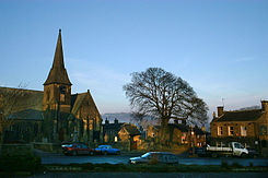
Church Street, Cullingworth, West Yorkshire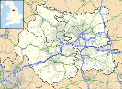
 Cullingworth
Cullingworth shown within West YorkshirePopulation 2,759 OS grid reference SE065365 Parish Cullingworth Metropolitan borough City of Bradford Metropolitan county West Yorkshire Region Yorkshire and the Humber Country England Sovereign state United Kingdom Post town BRADFORD Postcode district BD13 Dialling code 01535 Police West Yorkshire Fire West Yorkshire Ambulance Yorkshire EU Parliament Yorkshire and the Humber UK Parliament Shipley List of places: UK • England • Yorkshire Cullingworth is a village and civil parish in West Yorkshire, England, between Bradford and Haworth. The village is well known locally for holding events such as the Brontë Vintage Gathering every year and the Great Yorkshire Bike Show in 2005. The surrounding countryside is mainly used for sheep and cattle farming, with areas of moorland located nearby as well. The village has seen some new development recently, such as a new primary school, housing estates and shops.
Contents
Governance
Cullingworth is a civil parish with a parish council. It is in the Bingley Rural ward of the City of Bradford and the Shipley constituency of the UK Parliament.
Education
The village is home to the Parkside Secondary School, which was recently[when?] expanded in line with educational changes (the gradual demise of middle schools in favour of secondary schools which are combined middle and high schools), and now educates around 1200 pupils from the surrounding area.
Landmarks
Cullingworth also has a Methodist Church. There are two pubs: the Fleece, and the George. Old Spot Brewery, based in Cullingworth, is an award winning real-ale brewery.[1] Cullingworth once had a wool mill, owned by the Craven family. The mill lay derelict for some years after the wool milling industry collapsed, but it made national news when the mill caught fire. The lanolin in all of the timbers caused the mill fire to be very intense.
Sport
In 2007 The Cricket club had a highly successful season, with the first team winning the "Treble", 1st Division championship, and winning both the Keighley Cup and the league cup. In 2008 this was repeated with the 1st team retaining the League championship and cup and retaining the Keighley cup whach had been revised to a 20/20 format.[2]
Notable people
Cullingworth was once home to olympic swimmer Duncan Goodhew.
Cullingworth is home to Robin Luscombe (Born 1961) multiple motorcycle sidecar trials champion.
References
External links
Categories:- Geography of Bradford
- Villages in West Yorkshire
- Civil parishes in West Yorkshire
- West Yorkshire geography stubs


Wikimedia Foundation. 2010.