- Dyer County, Tennessee
-
Dyer County, Tennessee 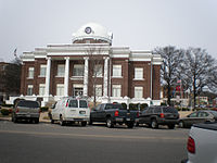 Dyer County Courthouse in Dyersburg, Tennessee
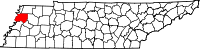
Location in the state of Tennessee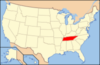
Tennessee's location in the U.S.Founded 1823 Seat Dyersburg Largest city Dyersburg Area
- Total
- Land
- Water
526 sq mi (1,364 km²)
510 sq mi (1,322 km²)
16 sq mi (41 km²), 3.04%Population
- (2010)
- Density
38,335
73/sq mi (28/km²)Time zone Central: UTC-6/-5 Dyer County is a county located in the westmost part of the U.S. state of Tennessee. As of 2010, the population was 38,335. Its county seat is Dyersburg.[1]
Contents
Geography
According to the U.S. Census Bureau, the county has a total area of 526 square miles (1,362.3 km2), of which 510 square miles (1,320.9 km2) is land and 16 square miles (41.4 km2) (3.04%) is water.
The county is bounded on the west by the Mississippi River, and it is drained by the Mississippi River. It is in the part of Tennessee called the "Mississippi bottomland".
Dyer County is bisected by U.S. Route 51, the older major highway connecting Memphis with Chicago from south to north. To the west, Dyer County is connected to Missouri by Interstate 155 over the Mississippi River, providing the only highway connection, other than those at Memphis, between Tennessee and the states to the west of "The Father of the Waters".
Adjacent Counties
- Lake County (north)
- Obion County (northeast)
- Gibson County (east)
- Crockett County (southeast)
- Lauderdale County (south)
- Mississippi County, Arkansas (southwest)
- Pemiscot County, Missouri (northwest)
History
Dyer County was founded by a Private Act of Tennessee, passed on October 16, 1823.[2] The area was part of the territory in Tennessee that was previously legally occupied by Chickasaw Native American people ("Indian Lands").[3]
The county was named for Robert Henry Dyer (circa 1774—1826). Dyer had been an army officer in the Creek War and War of 1812, and a cavalry colonel in the First Seminole War of 1818 before becoming a state senator. He was instrumental in the formation of the counties of Dyer and Madison County, Tennessee.[4]
Demographics
 Age pyramid Dyer County[5]
As of the census[6] of 2000, there were 37,279 people, 14,751 households, and 10,458 families residing in the county. The population density was 73 people per square mile (28/km²). There were 16,123 housing units at an average density of 32 per square mile (12/km²). The racial makeup of the county was 85.40% White, 12.86% Black or African American, 0.22% Native American, 0.33% Asian, 0.02% Pacific Islander, 0.43% from other races, and 0.73% from two or more races. 1.16% of the population were Hispanic or Latino of any race.
There were 14,751 households out of which 32.90% had children under the age of 18 living with them, 53.20% were married couples living together, 13.60% had a female householder with no husband present, and 29.10% were non-families. 25.30% of all households were made up of individuals and 10.70% had someone living alone who was 65 years of age or older. The average household size was 2.49 and the average family size was 2.97.
In the county, the population was spread out with 25.70% under the age of 18, 8.70% from 18 to 24, 28.60% from 25 to 44, 23.50% from 45 to 64, and 13.40% who were 65 years of age or older. The median age was 36 years. For every 100 females there were 92.00 males. For every 100 females age 18 and over, there were 88.80 males.
The median income for a household in the county was $32,788, and the median income for a family was $39,848. Males had a median income of $31,182 versus $21,605 for females. The per capita income for the county was $16,451. About 13.00% of families and 15.90% of the population were below the poverty line, including 21.00% of those under age 18 and 17.60% of those age 65 or over.
Noteworthy past events
On April 2, 2006 a severe weather system passed through Dyer County, producing tornadoes that killed 16 in the county and 24 in Tennessee.
Media
Radio Stations: BURKS BROADCASTING [SL100 / Eagle 97.3FM / WTRO-AM & FM]
- WASL-FM SL100: “Everything That Rocks”
- 50,000 watts covering 30 counties in Tennessee, Missouri, Kentucky, Arkansas since 1969
- City of License: Dyersburg, TN
- 500-foot Tower Site: Lenox
- WTNV-FM / Eagle 97.3: "Today’s Country & Your All-Time Favorites”
- 6,000 watts covering 40-45 mile radius of 10 counties in Tennessee, Missouri, & Kentucky since June 2007
- City of License: Tiptonville, TN [Lake County]
- 500-foot Tower Site: Elbridge [Obion County]
- AM1450 & 101.7FM / WTRO: “The Greatest Hits of All Time”
- 1,000 watts covering Dyer County & Northwest Tennessee since 1959
- City of License: Dyersburg, TN
- AM Tower Site: St John Avenue, Dyersburg, TN
- 100-foot Transmitter Site: Burks Place, Dyersburg, TN
- 300-foot Translator Site: Radio Road, Dyersburg, TN
Newspapers: State Gazette - 5 days/week (Sunday & Tuesday-Friday); general news. The paper has served Dyersburg and Northwest Tennessee since 1865.
Cities and towns
Unincorporated communities
- Bogota
- Finley
- Lenox
See also
References
- ^ "Find a County". National Association of Counties. http://www.naco.org/Counties/Pages/FindACounty.aspx. Retrieved 2011-06-07.
- ^ "Tennessee State Archives — formation of Dyer county". http://www.tn.gov/tsla/history/county/actdyer.htm. Retrieved 2010-12-01.
- ^ Bergeron, Paul H.; Ash, Stephen V.; Keith, Jeanette.Tennesseans and their history. Univ. of Tennessee Press, 1999, p. 78.
- ^ "Tennessee Blue Book — Dyer county". http://www.state.tn.us/sos/bluebook/05-06/44-counties.pdf#page=3. Retrieved 2010-12-01.
- ^ Based on 2000 census data
- ^ "American FactFinder". United States Census Bureau. http://factfinder.census.gov. Retrieved 2008-01-31.
External links

Pemiscot County, Missouri Lake County Obion County 
Gibson County  Dyer County, Tennessee

Mississippi County, Arkansas Lauderdale County Crockett County Municipalities and communities of Dyer County, Tennessee City 
Towns Unincorporated
communityBogota | Finley | Fowlkes
Footnotes ‡This populated place also has portions in an adjacent county or counties
Categories:- Tennessee counties
- Dyer County, Tennessee
- 1823 establishments in the United States
- Populated places established in 1823
- Tennessee counties on the Mississippi River


Wikimedia Foundation. 2010.