- Chagford
-
Coordinates: 50°40′22″N 3°50′25″W / 50.6728°N 3.8404°W
Chagford 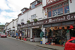
Chagford's famous ironmongery stores, Webbers and Bowdens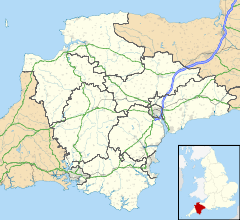
 Chagford
Chagford shown within DevonArea 11.7 sq mi (30 km2) [1] Population 1,470 [2](2001 Census) - Density 125.6 /sq mi (48.5 /km2) OS grid reference SX700876 - London 194 miles (312 km) Parish Chagford District West Devon Shire county Devon Region South West Country England Sovereign state United Kingdom Post town NEWTON ABBOT Postcode district TQ13 Dialling code 01647 Police Devon and Cornwall Fire Devon and Somerset Ambulance South Western EU Parliament South West England UK Parliament Torridge and West Devon Website http://www.chagford-parish.co.uk List of places: UK • England • Devon Chagford is a small town and civil parish on the north-east edge of Dartmoor, in Devon, England, close to the River Teign. It is located off the A382, about 4 miles (6 km) west of Moretonhampstead. The name Chagford is derived from the word chag, meaning gorse or broom, and the ford suffix indicates its importance as a crossing place on the River Teign. At the 2001 Census it had a population of 1,470.
Contents
History
Archaeological remains confirm that a community has existed here for at least 4000 years. In historical times, Chagford grew due to the wool trade and from tin mining in the area, and in 1305 was made a stannary town where tin was traded. A cattle market in the town survived until the 1980s.
In 1987, the New Scientist reported that Chagford contained "the most radioactive loo in the world",[3] a reference to the high levels of Radon gas in this granite area.
Today
Today Chagford is a thriving community with high property prices, busy streets, and an unusually wide range of shops for a village of this size. It is also known for its vibrant arts community, celebrated at the biennial Chagford Arts Festival, the annual Wonderworks crafts show, and other regular cultural events. The two large hardware stores in the town square have been run by the same two families for many years. There are several tea rooms and whole food cafés, one restaurant, and several pubs. There are numerous guest houses and hotels in the surrounding countryside. These provide accommodation for the large influx of visitors during the year.
The early 20th century Edwin Lutyens house Castle Drogo lies nearby in Drewsteignton parish, and overlooks Chagford.
Governance
The town has a Parish Council.
In 1976 Chagford was twinned with:
Regular twinning activity was sustained for over 20 years, but has now lapsed. Chagford retains its "Bretteville Close", and Bretteville its "Rue de Chagford".
Landmarks
A 16th century building called Endecott House, on the edge of the town square, was given this name in the early 1990s in honour of Pilgrim Father and governor of Massachusetts Bay Colony, John Endecott, who lived in Chagford before leaving for the New World. This building was possibly built as a "church house", and has certainly been in community use for many years, including use as a village school. It now serves as a meeting hall.
One of the social centres of Chagford is the village hall, the Jubilee Hall, in the south-east corner of the town next to the public car park. Built in 1936 by public subscription, it also houses the library (which opens three part-days a week). It provides a venue for the regular Friday morning flea markets as well as for a whole host of other activities: badminton, table tennis, parties, discos, comedy nights, kung fu, Pilates, etc. The town is beginning to outgrow this Hall, and there are periodic debates as to whether it should be further extended or replaced with a new building.
The Three Crowns Hotel dates to the 13th century and is reportedly haunted by the ghost of the cavalier poet, Sidney Godolphin, who died in the English Civil War.
Religion
 The church of St Michael the Archangel
The parish church of St Michael the Archangel was dedicated in 1261, although little remains from this period. The tower dates back to the 15th century. The Grade I listed building was restored in 1865 and extended during the 20th century. It features carved roof bosses, similar to those found at St. Pancras' church, Widecombe-in-the-Moor, including the tin miners’ emblem of three hares.
Chagford forms part of a "united benefice" of seven ecclesiastical parishes, known as The Whiddon Parishes of Dartmoor, the others being Throwleigh, Gidleigh, Drewsteignton, Spreyton, Hittisleigh and South Tawton.
A Wesleyan Chapel (est. 1834) was replaced by a Methodist church built in 1861; it closed in the 1990s and is now in secular use. Victorian era directories list a Baptist church (established 1829), but long since disappeared. However, the Bible Christian Chapel (est. 1844) continues to flourish as Chagford Gospel Church, and a purpose-built Roman Catholic church was founded in 1963.
Legend
St Michael's church contains a memorial to Mary Whiddon, dated 11 October 1641, whose death is thought to have been one of the inspirations behind R.D. Blackmore’s novel, Lorna Doone. Although his novel is set on Exmoor, the author may have been moved by a local legend about Mary who, it is claimed, was shot dead on her wedding day as she came out of church. The climax of Lorna Doone involves such a shooting, but in that case the heroine survives.
Whether this actually happened is unclear. Mary's tomb records that she died "a matron, yet a maid" ("a married woman, yet a virgin"). On the other hand, "maid" is a common term in Devon for a "girl" and the inscription may just mean that Mary died young ("although married, still just a girl"). The only contemporaneous record is her undated will. It mentions no husband, but as her maiden name is also thought to have been Whiddon (i.e. she married a cousin), it might have been written before her marriage.
Sports
Chagford's War Memorial Playing Fields were redeveloped in the late 1980s to provide a cricket ground to the south west of the village, overlooked by a modern clubhouse. In the winter, the ground provides two football (soccer) pitches for the football club. There are public tennis courts in the town, with an associated Tennis Club, and an open-air swimming pool.
References
- ^ White's Devonshire Directory (1850) Present day parish boundaries are essentially the same as the 1850 boundaries
- ^ Neighbourhood Statistics - Parish Headcounts
- ^ Pearce, Fred (February 5, 1987), "A deadly gas under the floorboards", New Scientist: p33-35, http://books.google.co.uk/books?id=g8D8jEfW4_YC&lpg=PA33&dq=dartmoor%20millisieverts&pg=PA33#v=onepage&q=dartmoor%20millisieverts&f=false
External links
Settlements of Dartmoor, Devon Ashburton · Belstone · Bovey Tracey · Brentor · Bridestowe · Buckfastleigh · Buckland-in-the-Moor · Chagford · Drewsteignton · Gidleigh · Haytor · Hexworthy · Holne · Ilsington · Ivybridge · Lustleigh · Lydford · Manaton · Mary Tavy · Moretonhampstead · Okehampton · Peter Tavy · Ponsworthy · Postbridge · Poundsgate · Princetown · Shaugh Prior · Sheepstor · Sourton · South Brent · South Tawton · South Zeal · Sticklepath · Tavistock · Walkhampton · Widecombe-in-the-Moor · Yelverton
Categories:- Towns in Devon
- Dartmoor


Wikimedia Foundation. 2010.