- Bethel, Alaska
-
Bethel, Alaska
Mamterillermiut
Orutsararmuit— City — Aerial view of Bethel on the Kuskokwim River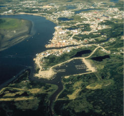 Location of Bethel within the state of Alaska
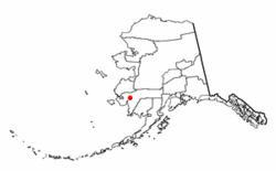
Coordinates: 60°47′32″N 161°45′21″W / 60.79222°N 161.75583°WCoordinates: 60°47′32″N 161°45′21″W / 60.79222°N 161.75583°W Country United States State Alaska Borough Unorganized Census Area Bethel ANCSA regional corporation Calista Incorporated 1957 Government[1][2] – Type 2nd Class City – Mayor Joseph Klejka joshua klejkas father – City Manager Lee Foley Area[2] – Total 48.9 sq mi (126.5 km2) – Land 43.8 sq mi (113.3 km2) – Water 5.1 sq mi (13.1 km2) Elevation 3 ft (1 m) Population (2006) – Total 6,356 – Density 125.0/sq mi (48.3/km2) – % Alaska Native 62 Time zone AST (UTC-9) – Summer (DST) ADT (UTC-8) ZIP code 99559 Area code 907 FIPS code 02-06520 GNIS feature ID 1398908 Website City of Bethel Bethel (Mamterilleq in Central Alaskan Yup'ik) is a city located near the west coast of the U.S. state of Alaska, 340 miles (550 km) west of Anchorage. Accessible only by air and river, Bethel is the main port on the Kuskokwim River and is an administrative and transportation hub for the 56 villages in the Yukon-Kuskokwim Delta.
Bethel is the largest community in western Alaska and in the Unorganized Borough, as well as the 9th largest in the state, with a population estimated to be 6,356 in 2006.[3] Bethel is home to the lone detention center in southwestern Alaska, the Yukon Kuskokwim Correction Center.[4] Bethel is also one of the latest communities in Alaska to opt out of status as a "Local Option" community, theoretically opening the door to allowing alcohol sales in the city, though residents and city officials maintain that all liquor license requests will be actively opposed.[5]
Annual events in Bethel include a noted dogsled race, the Kuskokwim 300, and Camai, a traditional dance festival held each spring.
Contents
History
Bethel, at its original location, was a Yup'ik village called Mamterillermiut, meaning "Smokehouse People", after the nearby fish smokehouse.[6] It was an Alaska Commercial Company trading post during the late 19th century. It had a population of 41 people in the 1880 U.S. Census. The Moravian Church established a mission in the area in 1885, under the leadership of Rev. John Henry Kilbuck, Jr. Kilbuck learned Yup'ik, which greatly enhanced his effectiveness as a missionary. Missionaries moved Bethel from Mamterillermiut to its present location on the west side of the Kuskokwim River. A United States Post Office was opened in 1905.
Alaska Natives in this area also have a long Christian history, in part from Russian Orthodox, Catholic and Moravian influence. As in many Alaskan villages, Christian tradition has become interwoven with its cultural history.
Geography
Bethel is located at 60°47′32″N 161°45′21″W / 60.79222°N 161.75583°W (60.792222, −161.755833)[7].
According to the United States Census Bureau, the city has a total area of 48.8 square miles (126 km2). 43.8 square miles (113 km2) of it is land and 5.1 square miles (13 km2) of it (10.39%) is water.
Though the region is flat and generally treeless, Bethel lies inside the Yukon Delta National Wildlife Refuge, the second largest wildlife refuge in the United States.
Climate
Bethel has a subarctic climate (Köppen Dfc), with long, somewhat snowy, and very cold winters, and short, mild summers. Monthly daily average temperatures range from 6.6 °F (−14.1 °C) in January to 56.0 °F (13.3 °C) in July, with an annual mean of 29.9 °F (−1.2 °C). Warm days of above 70 °F (21 °C) can be expected on 13 days per summer,.[8] Precipitation is both most frequent and greatest during the summer months, averaging 16.2 inches (411 mm) per year. Snowfall usually falls in light bouts, and is actually greater in November and December than in January and February, averaging 45 inches (114 cm) a season. Extreme temperatures have ranged from −48 °F (−44 °C) to 90 °F (32 °C).
Climate data for Bethel, Alaska Month Jan Feb Mar Apr May Jun Jul Aug Sep Oct Nov Dec Year Record high °F (°C) 49
(9)51
(11)53
(12)63
(17)80
(27)90
(32)86
(30)87
(31)76
(24)65
(18)60
(16)49
(9)90
(32)Average high °F (°C) 12.4
(−10.9)13.9
(−10.1)21.8
(−5.7)33.3
(0.7)49.4
(9.7)59.4
(15.2)63.1
(17.3)59.7
(15.4)51.7
(10.9)35.3
(1.8)23.1
(−4.9)15.6
(−9.1)36.6 Average low °F (°C) 0.7
(−17.4)1.3
(−17.1)7.2
(−13.8)18.4
(−7.6)33.1
(0.6)43.3
(6.3)48.8
(9.3)47.5
(8.6)39.1
(3.9)24.7
(−4.1)11.7
(−11.3)3.2
(−16.0)23.3 Record low °F (°C) −48
(−44)−40
(−40)−42
(−41)−31
(−35)−5
(−21)28
(−2)30
(−1)28
(−2)18
(−8)−6
(−21)−31
(−35)−44
(−42)−48
(−44)Precipitation inches (mm) .62
(15.7).51
(13).67
(17).65
(16.5).85
(21.6)1.60
(40.6)2.03
(51.6)3.02
(76.7)2.31
(58.7)1.43
(36.3)1.37
(34.8)1.12
(28.4)16.18
(411)Snowfall inches (cm) 5.8
(14.7)3.8
(9.7)6.5
(16.5)4.1
(10.4)1.7
(4.3).1
(0.3)0
(0)0
(0).3
(0.8)3.8
(9.7)8.9
(22.6)9.5
(24.1)44.5
(113)Avg. precipitation days (≥ 0.01 in) 8.7 5.8 8.6 8.9 11.0 13.2 15.1 18.3 17.2 12.7 11.8 11.0 142.3 Avg. snowy days (≥ 0.1 in) 7.9 4.8 7.7 6.9 2.3 .1 0 0 .5 5.9 9.1 9.0 54.2 Source: NOAA (normals, 1971−2000),[8] Weather.com (extremes) [9] Demographics
Historical populations Census Pop. %± 1910 110 — 1920 221 100.9% 1930 278 25.8% 1940 376 35.3% 1950 651 73.1% 1960 1,258 93.2% 1970 2,416 92.1% 1980 3,576 48.0% 1990 4,674 30.7% 2000 5,471 17.1% 2010 6,080 11.1% source:[10] As of the census of 2000,[11] there were 5,471 people, 1,741 households, and 1,190 families residing in the city. The population density was 125.0 people per square mile (48.3/km²). There were 1,990 housing units at an average density of 45.5 per square mile (17.6/km²). The racial makeup of the city was 26.83% White, 0.93% Black or African American, 61.78% Native American, 2.87% Asian, 0.16% Pacific Islander, 0.51% from other races, and 6.91% from two or more races. Hispanics or Latinos of any race were 1.70% of the population.
There were 1,741 households out of which 44.1% had children under the age of 18 living with them, 42.6% were married couples living together, 15.2% had a female householder with no husband present, and 33.7% were non-families. 24.5% of all households were made up of individuals and 3.2% had someone living alone who was 65 years of age or older. The average household size was 3.00 and the average family size was 3.65.
The age distribution was 35.5% under 18, 9.0% from 18 to 24, 32.7% from 25 to 44, 18.9% from 45 to 64, and 3.9% who were 65 or older. The median age was 29 years. For every 100 females there were 110.4 males. For every 100 females age 18 and over, there were 109.6 males.
The median income for a household in the city was $57,321, and the median income for a family was $62,431. Males had a median income of $45,321 versus $39,010 for females. The per capita income for the city is $20,267. About 10.6% of the families and 11.2% of the population were below the poverty line, including 9.7% of those under the age of 18 and 18.3% of those ages 64 and over.
Transportation and economy
The state-owned Bethel Airport is the regional transportation center, and is served by seven passenger carriers, including Alaska Airlines, Grant Aviation, Hageland Aviation Services, Yute Air and Frontier Flying Service. It also receives service from five cargo operators: Everts Air Cargo, Northern Air Cargo, Alaska Central Express, Arctic Transportation Services, and Lynden Air Cargo, and numerous small air taxi services including Renfro's Alaskan Adventures. The airport ranks third in the state for total number of flights. It offers a 6,400 foot asphalt runway and 1,850 foot gravel crosswind runway, and is currently undergoing a $7 million renovation and expansion. Three float plane bases are nearby: Hangar Lake, H Marker Lake, and the Kuskokwim River.
The Port of Bethel is the northernmost medium-draft port in the United States. River travel is the primary means of local transportation in the summer. A Bethel-based barge service provides goods to Kuskokwim villages.
Within Bethel there are approximately 16 miles (26 km) of roads which are not connected to any contiguous highway system. Winter ice roads lead to several local villages, but their condition varies depending on temperature and snow fall.
An extensive network of snow machine trails connects Bethel to villages all over the Delta, from the Bering Sea to the Yukon.
The town's single paved road—about 10 miles—supports a surprisingly large taxicab industry. With 93 taxi drivers, the town has more cab drivers per capita than any other city in the country, making it the unlikely taxicab capital of the United States. Just as surprising, most local cab drivers are Albanian or South Korean immigrants lured north by reports of good money.[12]
A relatively recent addition to the economy of Bethel is farming. Initiated by a small organic farm, local food production in Bethel has been increasing.[13] A winner of the Alaska Marketplace competition, the Meyers Farm has been providing organic produce for the local population of Bethel.
Bethel is also the site of a proposed major, relative to Alaska, coal powered generating station, and a unique 8.5-mile (13.7 km) prototype single-wire earth return electrical intertie to Napakiak, Alaska, constructed in 1981.[14]
Education
MikeInguut Elitnaurviat elementary school
LKSD Bethel Regional high school
Kilbuck elementary school
Bethel Alternative Boarding school
Kuskokwim campus University of Alaska-Fairbanks
Sports and recreation
Bethel is home to a noted mid-distance dogsled race, the Kuskokwim 300. Held every January since 1980, the race commemorates an early mail route that once tied the settlement to the outside world. Top mushers and hundreds of sled dogs participate in the race for a purse of $100,000, the largest offered by any 300-mile (480 km) sled dog race.[15]
Local recreational activities include snow machining, skiing, bicycling, kayaking, caribou hunting, and salmon fishing.
Arts and culture
Traditional dancers from all over Alaska and beyond participate every March in the Camai Dance Festival. Hundreds of costumed dancers, drummers, and singers perform traditional Yup'ik story dances during the three-day festival, sponsored by the Bethel Council on the Arts. "Camai" (pronounced Cha-Mai) translates as "a warm hello."[16]
Media
Bethel has a public television station, KYUK-TV, and two radio stations, public KYUK and private KYKD. It is also home to the weekly regional newspapers Delta Discovery and Tundra Drums.
Sister cities
Bethel has 1 official sister city.
 Anadyr, Chukotka Autonomous Okrug, Russian Federation
References
- ^ City of Bethel. (2006-10-27). "Bethel City Council Member List." Retrieved on 2007-04-13.
- ^ a b Community Information Summaries: Bethel. Alaska Community Database Online, Alaska Department of Commerce, Community, and Economic Development. Retrieved on 2007-04-13.
- ^ "Annual Estimates of the Population for All Incorporated Places in Alaska" (CSV). 2006 Population Estimates. U.S. Census Bureau, Population Division. 2007-06-28. http://www.census.gov/popest/cities/tables/SUB-EST2006-04-02.csv. Retrieved 2007-11-30.
- ^ Alaska Dept of Corrections
- ^ "Election Results". City of Bethel. 2009-10-06. http://www.cityofbethel.org/index.asp?Type=B_BASIC&SEC={1F6B5F4B-45F4-4573-8E4D-45FD5014FC0B}. Retrieved 2009-10-07.
- ^ Orth, Donald. Dictionary of Alaska Placenames. Page 128.
- ^ "US Gazetteer files: 2010, 2000, and 1990". United States Census Bureau. 2011-02-12. http://www.census.gov/geo/www/gazetteer/gazette.html. Retrieved 2011-04-23.
- ^ a b "Climatology of the United States No. 20 1971−2000: BETHEL AP, AK" (PDF). National Oceanic and Atmospheric Administration. 2004. http://cdo.ncdc.noaa.gov/climatenormals/clim20/ak/500754.pdf. Retrieved 2011-01-18.
- ^ "Average Weather for Bethel, AK − Temperature and Precipitation". Weather.com. http://www.weather.com/outlook/health/fitness/wxclimatology/monthly/graph/USAK0028. Retrieved 2010-08-27.
- ^ "Census Of Population And Housing". U.S. Census Bureau. http://www.census.gov/prod/www/abs/decennial/index.htm. Retrieved 2011-07-04.
- ^ "American FactFinder". United States Census Bureau. http://factfinder.census.gov. Retrieved 2008-01-31.
- ^ Tizon, Tomas Alex (2007-11-30). "America's Taxi Capital: Bethel, Alaska". Los Angeles Times. http://www.latimes.com/news/nationworld/nation/la-na-taxicabs30nov30,1,3238044.story?ctrack=1&cset=true. Retrieved 2007-11-30.
- ^ Meyers Farm[dead link]
- ^ Frank Bettine (2002-9). "SWGR Transmission". http://www.alaska.edu/uaf/cem/ine/aetdl/conferences/2002_sept_docs/singlewiregroundreturn.pdf. Retrieved 2011-11-7.
- ^ "Kuskokwim 300". http://k300.org. Retrieved 2007-11-30.
- ^ Bethel Council on the Arts (2011). "Cama=i Dance Festival". Bethel, Alaska. http://bethelarts.com/. Retrieved 2011-11-7.
External links
- Bethel Weather Website
- BethelAK Information Website
- City of Bethel
- Bethel Council on the Arts
- Bethel Lions Club
- Bethel Regional High School
- Bethel, Alaska at the Open Directory Project
Municipalities and communities of Bethel Census Area, Alaska Cities Akiak | Aniak | Bethel | Chefornak | Chuathbaluk | Eek | Goodnews Bay | Kwethluk | Lower Kalskag | Mekoryuk | Napakiak | Napaskiak | Nightmute | Nunapitchuk | Platinum | Quinhagak | Toksook Bay | Upper Kalskag
CDPs Akiachak | Atmautluak | Crooked Creek | Kasigluk | Kipnuk | Kongiganak | Kwigillingok | Lime Village | Newtok | Oscarville | Red Devil | Sleetmute | Stony River | Tuluksak | Tuntutuliak | Tununak
Unincorporated
communities State of Alaska
Topics - Index
- Geography
- Climate
- Wildlife
- History
- People
- Transportation
- Government
- Delegations
- Music
- Visitor attractions
Society - Culture
- Crime
- Demographics
- Economy
- Education
- Health (Rural dentistry)
- Politics
Regions - Aleutian Islands
- Arctic Alaska
- Bush Alaska
- Inside Passage
- Interior
- Kenai Peninsula
- Mat‑Su Valley
- North Slope
- Southeast
- Seward Peninsula
- Southcentral
- Southwest
- Tanana Valley
- Yukon–Kuskokwim Delta
Largest cities Boroughs Census Areas - Aleutians West
- Bethel
- Dillingham
- Hoonah‑Angoon
- Nome
- Petersburg
- Prince of Wales‑Hyder
- Southeast Fairbanks
- Valdez‑Cordova
- Wade Hampton
- Yukon‑Koyukuk
Categories:- Cities in Alaska
- Bethel, Alaska
- Populated places in Bethel Census Area, Alaska
- Populated places in Alaska with Native American majority populations
- History of the Alaska Province of the Moravian Church


Wikimedia Foundation. 2010.