- Wasilla, Alaska
-
"Wasilla" redirects here. For the Ossetian god of the same name, see Ossetian mythology.
Wasilla, Alaska — city —  Location of Wasilla, Alaska
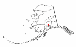 Detailed map of Wasilla
Coordinates: 61°34′54″N 149°27′9″W / 61.58167°N 149.4525°WCoordinates: 61°34′54″N 149°27′9″W / 61.58167°N 149.4525°W Country United States State Alaska Borough Matanuska-Susitna Government - Mayor Verne E. Rupright Area - Total 12.4 sq mi (32.2 km2) - Land 11.7 sq mi (30.3 km2) - Water 0.7 sq mi (1.8 km2) Elevation 341 ft (104 m) Population (2010) - Total 7,831 - Density 669.3/sq mi (258.4/km2) Time zone Alaska (AKST) (UTC-9) - Summer (DST) AKDT (UTC-8) ZIP codes 99600-99699 Area code 907 FIPS code 02-83080 GNIS feature ID 1411788 Website www.cityofwasilla.com Wasilla is a city in Matanuska-Susitna Borough, United States and the sixth-largest city in Alaska. It is located on the northern point of Cook Inlet in the Matanuska-Susitna Valley of the southcentral part of the state. The city's population was 7,831 at the 2010 census. Wasilla is the largest city in the borough and a part of the Anchorage metropolitan area, which had an estimated population of 364,701 in 2008.
Established at the intersection of the Alaska Railroad and Old Carle Wagon Road, the city prospered at the expense of the nearby mining town of Knik. Historically entrepreneurial, the economic base shifted in the 1970s from small-scale agriculture and recreation to support for workers employed in Anchorage or on Alaska's North Slope oilfields and related infrastructure. The George Parks Highway turned the town into a commuter suburb of Anchorage.[1] Several state and federal agencies have offices in Wasilla, including the Alaska Departments of Environmental Conservation, Labor and Divisions of Public Assistance, Social Services.
Wasilla gained international attention when Sarah Palin, who served as Wasilla's mayor before her election as Governor of Alaska, was chosen by John McCain as his vice-presidential running mate in the 2008 United States presidential election.
Wasilla is named after Chief Wasilla, a local Dena'ina chief.[2] "Wasilla" is the anglicized spelling of the chief's Russian-given name, Vasilij, which corresponds to the English name Basil.[3]
Contents
History
Glacial ice sheets covered most of the northern hemisphere during the last glacial period, between 26,500 and 19,000–20,000 years ago[4], until they disappeared between 10,000 and about 7,000 years ago.[5] Early humans moved through the area and left evidence of their passage.[5] The Matanuska-Susitna valley was eventually settled by the Dena'ina Alaska natives who utilized the fertile lands and fishing opportunities of Cook Inlet. The Dena'ina are one of the eleven sub-groups comprising the indigenous Athabaskan Indian groups extending down Canada's western coast. Russians occupied Alaska from 1741, including strategic trading posts in Lower Cook Inlet, until Alaska's sale to the United States in 1867.[6] Near the mouth of the Matanuska River, the town of Knik was settled about 1880. In 1900, the Willow Creek Mining District was established to the north and Knik thrived as a mining settlement.[7]
 Mountains near Wasilla
In 1917, the U.S. government planned the Alaska Railroad to intersect the Carle Wagon Road (present Wasilla-Fishhook Road) which connected Knik and the mines.[8] Knik businesses and residents rushed to purchase plattes and the town declined. Wasilla Station was named for the nearby Wasilla Creek. Local miners used the name "Wassila Creek", referring to Wassila, a chief of the Dena'ina. There are two sources cited for the name, one being derived from a Dena'ina word meaning "breath of air" while another stating Dena'ina derived it from the Russian name "Vasili."[9][10] As Knik declined into a ghost town, Wasilla served early fur trappers and miners working the gold fields at Cache Creek and Willow Creek. More than 200 farm families from the Upper Midwest were moved into the Matanuska and Susitna valleys in 1935 as part of a U.S. government program to start a new farming community to counteract this trend; their linguistic influence is still audible in the region.[11]
The area was a supply base for gold mines near Hatcher Pass through World War II. Until construction of the George Parks Highway around 1970, nearby Palmer was the leading city in the Matanuska Valley. Wasilla was at the end of the Palmer-Wasilla highway and the road to Big Lake provided access to land west of Wasilla. The Parks Highway put Wasilla at mile 40-42 of what became the major highway and railroad transportation corridor linking Southcentral Alaska to Interior Alaska. As a result, population growth and community development shifted from the area around Palmer to Wasilla and the surrounding area. Wasilla was incorporated as a city in 1974.[12] All non-borough municipalities throughout Alaska are designated cities.[13]
In 1994, a statewide ballot initiative to move the capital of Alaska to Wasilla was defeated by a vote of about 116,000 to 96,000.[14][15] About that time, the Matanuska Valley began to recover from an economic collapse, beginning a sustained boom that involved dramatic population growth, increased local employment, and a boom in residential and commercial real estate development.[16] The local real estate market slowed in 2006. In 2008, suburban growth and dwindling snow forced organizers of the Iditarod Trail Sled Dog Race to bypass Wasilla permanently.[17] The race had its start in Wasilla from 1973 to 2002, the year when reduced snow cover forced a "temporary" change to Willow.[17]
Geography
Wasilla is located at 61°34′54″N 149°27′9″W / 61.58167°N 149.4525°W (61.581732, -149.452539).[18]
According to the United States Census Bureau, the city has an area of 12.4 square miles (32.2 km²). 11.7 square miles (30.4 km²) of it is land and 0.7 square miles (1.8 km²) of it (5.64%) is water.
The Dena'ina (Tanaina) Native Americans called the area Benteh, meaning 'among the lakes'.[19]
Located near Wasilla Lake and Lake Lucille, Wasilla is one of two cities in the Matanuska Valley. The community surrounds Mi. 39-46 of the George Parks Highway, roughly 43 highway miles (69.2 km) northeast of Anchorage. Nearly one third of the people of Wasilla drive the 40-minute commute to work in Anchorage every day.[20]
Climate
January temperatures range from 4 °F (−16 °C) to 29 °F (−2 °C); July temperatures vary from 47 °F (8 °C) to 78 °F (26 °C). The average annual precipitation is 17 inches (430 mm), with 50 inches (130 cm) of snowfall.
Climate data for Wasilla, Alaska Month Jan Feb Mar Apr May Jun Jul Aug Sep Oct Nov Dec Year Record high °F (°C) 56
(13)56
(13)65
(18)73
(23)83
(28)91
(33)87
(31)85
(29)76
(24)69
(21)58
(14)55
(13)91
(33)Average high °F (°C) 22.2
(−5.4)27.6
(−2.4)36.0
(2.2)47.6
(8.7)59.8
(15.4)66.6
(19.2)69.4
(20.8)67.2
(19.6)58.5
(14.7)42.6
(5.9)28.9
(−1.7)22.8
(−5.1)45.8 Daily mean °F (°C) 13.8
(−10.1)18.8
(−7.3)26.3
(−3.2)37.5
(3.1)47.9
(8.8)55.1
(12.8)58.8
(14.9)56.6
(13.7)48.6
(9.2)34.4
(1.3)21.0
(−6.1)14.7
(−9.6)36.13
(2.29)Average low °F (°C) 5.5
(−14.7)10.1
(−12.2)16.7
(−8.5)27.5
(−2.5)36.0
(2.2)43.7
(6.5)48.3
(9.1)46.0
(7.8)38.7
(3.7)26.3
(−3.2)13.2
(−10.4)6.6
(−14.1)26.6 Record low °F (°C) −40
(−40)−41
(−41)−30
(−34)−16
(−27)8
(−13)27
(−3)−14
(−26)27
(−3)−14
(−26)−14
(−26)−25
(−32)−40
(−40)−41
(−41)Precipitation inches (mm) 0.8
(20)0.9
(23)0.5
(13)0.7
(18)0.8
(20)1.6
(41)2.5
(64)2.7
(69)2.7
(69)1.8
(46)1.2
(30)1.0
(25)17.2
(437)Snowfall inches (cm) 8.4
(21.3)8.9
(22.6)5.8
(14.7)2.5
(6.4)0.1
(0.3)0
(0)0
(0)0
(0)0
(0)4.7
(11.9)8.7
(22.1)12.8
(32.5)52.1
(132.3)Source: weatherbase.com [21] Demographics
Historical populations Census Pop. %± 1930 51 — 1940 96 88.2% 1950 97 1.0% 1960 112 15.5% 1970 300 167.9% 1980 1,559 419.7% 1990 4,028 158.4% 2000 5,469 35.8% 2010 7,831 43.2% source:[22] As of the census of 2000,[23] there were 5,469 people (up from 4,028[24] in 1990), 1,979 households, and 1,361 families residing in the city. The population density was 466.8 people per square mile (180.2/km²). There were 2,119 housing units at an average density of 180.9 per square mile (69.8/km²). The racial makeup of the city was 85.46% White, 0.59% Black or African American, 5.25% Native American, 1.32% Asian, 0.13% Pacific Islander, 1.32% from other races, and 5.94% from two or more races. Hispanic or Latino of any race were 3.68% of the population.
There were 1,979 households out of which 43.5% had children under the age of 18 living with them, 50.2% were married couples living together, 13.8% had a female householder with no husband present, and 31.2% were non-families. 23.5% of all households were made up of individuals and 6.8% had someone living alone who was 65 years of age or older. The average household size was 2.76 and the average family size was 3.27.
In the city the age distribution of the population shows 33.6% under the age of 18, 10.0% from 18 to 24, 30.7% from 25 to 44, 19.0% from 45 to 64, and 6.7% who were 65 years of age or older. The median age was 30. For every 100 females there were 99.5 males; for every 100 females age 18 and over, there were 95.0 males.
The median income for a household in the city was $48,226, and the median income for a family was $53,792. Males had a median income of $41,332 versus $29,119 for females. The per capita income for the city was $21,127. About 5.7% of families and 9.6% of the population were below the poverty line, including 12.6% of those under the age of 18 and 9.7% of those 65 and older.
Economy
Wasilla began as a transportation logistics & trade center serving natural resource extraction (mining, trapping & timber) followed by small-scale agricultural activity circa 1935; around 1975, construction of the Parks Highway substantially reduced travel time to Anchorage, encouraging the transition to a satellite bedroom community where workers commute to Anchorage for employment.[25] Local service employment has increased in recent years.[26]
About 35 percent of the Wasilla workforce commutes to Anchorage.[20] The local economy is diverse, and residents are employed in a variety of city, borough, state, federal, retail and professional service positions.[27] Tourism, agriculture, wood products, steel, and concrete products are part of the economy. One hundred and twenty area residents hold commercial fishing permits; commercial fishermen work seasonally in Lower Cook Inlet and distant Bristol Bay or the Gulf of Alaska & Prince William Sound (there are no commercial fisheries in Upper Cook Inlet).[26]
Recreation
 Wasilla Lake and Lake Lucille are both within the city limits and easily accessible by road
The Museum of Alaska Transportation and Industry in Wasilla was established in 1967, "to give a home to the transportation and industrial remnants and to tell the stories of the people and the machines that opened Alaska to exploration and growth."[28]
The Alaska Avalanche hockey team of the NAHL play home games in Wasilla at the Curtis D. Menard Memorial Sports Center (formerly called the Wasilla Multi-Use Sports Complex).[29] In 2010, the Menard Center lost a tenant when the Arctic Predators did not play as a member of the Indoor Football League.[30]
Charles Wohlforth, in a Frommer's travel guidebook on Alaska, described Wasilla as "...the worst kind of suburban sprawl of highway-fronting shopping malls and gravel lots."[31]
Nude dancing and striptease acts are not allowed.[32]
Government
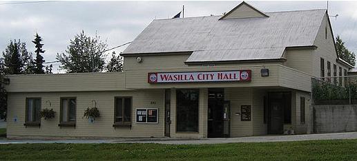
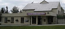 Wasilla City Hall, August 2008
The Wasilla City Council is the city's legislature; it enacts laws and policy statements, sets the property tax rate, and approves the budget and funds for city services. It has six members, elected at-large by Wasilla residents for three year terms.[33] The Mayor is elected separately. A run-off election will be held if no candidate for Mayor receives more than 40% of the votes cast. Run-off elections are not held for city council seats. All positions are part time.
The following is a list of mayors of Wasilla.
-
This list is incomplete; you can help by expanding it.
Time in office Name Notes 1983–1984 Richard "Ken" DeCamp [34] 1985–1986 Charlie Bumpus [35] 1986–1987 Harold Newcomb [36] 1987–1996 John Stein [37] 1996–2002 Sarah Palin [38] 2002–2008 Dianne M. Keller [38] 2008–present Verne E. Rupright [39] Education and health
Wasilla is served by the Matanuska-Susitna Borough School District. It has four high schools:[40]
- Burchell High School
- Mat-Su Career and Technical High School
- MidValley High School
- Wasilla High School
In January 2006 a new hospital, Mat-Su Regional Medical Center, opened. It is outside the city limits halfway between Wasilla and its twin city of Palmer.[41]
Transportation
The Glenn Highway connects Wasilla to Anchorage and communities on the Kenai Peninsula, the Glenn, along with the George Parks Highway link the Matanuska Valley to northward to the rest of the state and Canada. The Alaska Railroad serves Wasilla.
The city-owned Wasilla Airport, with a paved 3,700 foot (1,130 m) runway, provides air taxi services.[42] Wasilla also has eight public-use seaplane bases located on area lakes.[43] Private-use air facilities registered with the FAA include 43 land-based airstrips, eight additional seaplane bases, two heliports and one STOLport.[43]
Religion
- Wasilla Assembly of God was founded in 1951 and is a member of the Assemblies of God denomination.[44] The church's founding pastor was Paul Riley, and its current pastor is Ed Kalnins, who took over in 1999.
- Wasilla Bible Church, non-denominational, evangelical church, was described by Time as one of the largest and most influential churches in the city.[45]
- The Roman Catholic Sacred Heart Parish.[46]
- St. Lazarus Russian Orthodox Mission, affiliated with the Orthodox Church in America, meets in the old chapel at Sacred Heart Parish.[47]
- St. Herman Mission, affiliated with the Antiochian Orthodox Christian Archdiocese of North America.[48]
- The Church of Jesus Christ of Latter-day Saints has a stake based in Wasilla, with several wards meeting in a chapel on E Dellwood St.[49]
- Wasilla Church of Christ[50]
- St. David's Episcopal Church
- Meier Lake Episcopal Conference Center.[51]
- Good Shepherd Lutheran Church was founded in the late 1970s and is a member of the Evangelical Lutheran Church in America (ELCA). Its current pastor is Rev. Duane Hanson, and its youth director is Ian McConnell.
Notable residents
- Chad Carpenter,[52] cartoonist and creator of the comic strip Tundra
- Mahala Ashley Dickerson, Alaska's first African-American lawyer
- Lyda Green, former President of the Alaska Senate
- Diana Espen, known as April Flowers, adult film star
- Charlie Huggins, Alaska Senate, Silver Star recipient
- Lisa Kelly, Ice Road Truckers Season 3 and 4 Driver
- Vic Kohring, state legislator[53]
- Specialist Jeremy Morlock, a U.S. Army soldier who murdered three civilians in Afghanistan.[54][55]
- Members of the Palin family:
- Sarah Palin, former mayor of Wasilla, former Alaska Governor, and 2008 Republican vice presidential candidate
- Todd Palin, professional snowmobile racer, four-time Iron Dog race champion, husband of Sarah Palin
- Bristol Palin, Teen Abstinence Ambassador for the Candie's Foundation, daughter of Todd and Sarah Palin [56][57]
- Levi Johnston, former fiancé of Bristol Palin, Playgirl model
- John Gourley and Zachary Carothers, members of the indie rock band Portugal. The Man
- Landon Swank, magician, finalist on the sixth season of America's Got Talent
References
- ^ Alaska Economic Trends. Alaska Department of Labor and Workforce Development. http://state.ak.us/trends/. Retrieved October 24, 2008.
- ^ "Wasilla History". city of Wasilla. 2008-09-23. http://www.cityofWasilla.com/index.aspx?page=82.
- ^ Bright, William (2004). Native American placenames of the United States. University of Oklahoma Press. p. 551. ISBN 9780806135984. http://books.google.com/books?id=5XfxzCm1qa4C&pg=PA551. Retrieved 11 April 2011.
- ^ "The Last Glacial Maximum". Peter U. Clark, Arthur S. Dyke, Jeremy D. Shakun, Anders E. Carlson, Jorie Clark, Barbara Wohlfarth, Jerry X. Mitrovica, Steven W. Hostetler, A. Marshall McCabe. American Association for the Advancement of Science. 7 August 2009: Vol. 325. no. 5941, pp. 710 - 714. doi:10.1126/science.1172873. http://www.sciencemag.org/cgi/content/short/325/5941/710. Retrieved 2010-01-27.
- ^ a b Hollander, Zaz (June 29, 2005). "Archaeological dig perplexes; Trapper Creek: Team from Nevada didn't discover what it had been expecting". Anchorage Daily News. http://dwb.adn.com/news/alaska/story/6659592p-6546429c.html. Retrieved October 23, 2008.
- ^ "Palmer History". Palmer Museum of History and Art. http://www.palmermuseum.org/id29.htm. Retrieved 2008-10-23.[dead link]
- ^ "About Knik". Wasilla Knik Historical Society. March 2006. http://www.members.tripod.com/knik_alaska/id2.htm. Retrieved 2008-10-23.
- ^ "About Wasilla, Alaska". Greater Wasilla Chamber of Commerce. 2007. http://www.wasillachamber.org/wasilla/community.htm. Retrieved 2008-10-23.[dead link]
- ^ "Wasilla: Community Overview". Community Database Online. Alaska Division of Community Advocacy. http://www.dced.state.ak.us/dca/commdb/CF_BLOCK.cfm?Comm_Boro_Name=Wasilla&Data_Type=Overview. Retrieved 2008-10-23.
- ^ Orth, Donald Orth (1967). Dictionary of Alaska Place Names, U.S. Geological Survey Professional Paper 567. U.S. Government Printing Office.
- ^ Bauer, Scott. "Palin's speech has '30s roots, don't cha know: UW linguists’ research article." Milwaukee Journal Sentinel Nov. 15, 2009
- ^ "Visitors: What's the Climate Like?". city of Wasilla, Alaska. August 19, 2008. http://www.cityofWasilla.com/index.aspx?page=119. Retrieved 2008-09-01. "Agriculture and natural resources sustained growth and the city was incorporated in 1974."
- ^ §29.04.010 and §29.04.030 of the Alaska Code. Retrieved 2008-10-23.
- ^ Hernandez, Raymond; Hershey Jr, Robert D.; Holloway, Lynette; Kennedy, Randy; Labaton, Stephen; Lewin, Tamar; Lewis, Neil A.; Onishi, Norimitsu et al. (November 10, 1994). "The 1994 Elections: State by State; West". The New York Times. http://query.nytimes.com/gst/fullpage.html?res=9403E5D91E3EF933A25752C1A962958260. Retrieved 2008-09-09.
- ^ "Alaska's 1994 General Election Results Summary". Alaska Division of Elections, State of Alaska. Archived from the original on 2008-08-01. http://web.archive.org/web/20080801054315/http://www.elections.alaska.gov/result94.htm#bal3. Retrieved 2008-09-09.
- ^ (PDF) Alaska Economic Trends. Alaska Department of Labor and Workforce Development. January 2003. http://labor.state.ak.us/trends/jan03.pdf.
- ^ a b D'Oro, Rachel (January 10, 2008). "Warming Forces Iditarod Changes". Fox News. Associated Press. http://www.foxnews.com/wires/2008Jan10/0,4670,IditarodChanges,00.html. Retrieved September 17, 2008.
- ^ "US Gazetteer files: 2010, 2000, and 1990". United States Census Bureau. 2011-02-12. http://www.census.gov/geo/www/gazetteer/gazette.html. Retrieved 2011-04-23.
- ^ "Dena'ina Qenaga - Placenames". Qenaga.org. http://qenaga.org/placenames.html. Retrieved 2011-01-07.
- ^ a b "Community Profile: At Work". city of Wasilla, Alaska. July 9, 2008. Archived from the original on 2008-03-08. http://web.archive.org/web/20080308083356/http://www.cityofwasilla.com/profile/profile_05.asp. Retrieved 2008-09-01.
- ^ "Historical Weather for Wasilla, Alaska USA". weatherbase.com. http://www.weatherbase.com/weather/weather.php3?s=957905&refer=&units=us. Retrieved November 7, 2008.
- ^ "Census Of Population And Housing". U.S. Census Bureau. http://www.census.gov/prod/www/abs/decennial/index.htm. Retrieved 2008-10-16.
- ^ "Wasilla, Alaska". Census 2000 Demographic Profile Highlights. U.S. Census Bureau. http://factfinder.census.gov/servlet/SAFFFacts?_event=Search&geo_id=&_geoContext=&_street=&_county=wasilla&_cityTown=wasilla&_state=04000US02&_zip=&_lang=en&_sse=on&pctxt=fph&pgsl=010&show_2003_tab=&redirect=Y. Retrieved 2008-08-30.
- ^ "Wasilla city, Alaska - Population Finder - American FactFinder". U.S. Census Bureau. http://factfinder.census.gov/servlet/SAFFPopulation?_event=Search&_name=wasilla&_state=04000US02&_county=wasilla&_cityTown=wasilla&_zip=&_sse=on&_lang=en&pctxt=fph. Retrieved 2008-09-12.
- ^ Interview Neil Fried, AK DOL economist @ 907 269-4861
- ^ a b "2011 Alaska Economic Trends". Labor.state.ak.us. 2011-01-03. http://labor.state.ak.us/trends/. Retrieved 2011-01-07.
- ^ "January 2003 Trends" (PDF). http://labor.state.ak.us/trends/jan03.pdf. Retrieved 2011-01-07.
- ^ "About Us". Museum of Alaska Transportation and Industry. http://museumofalaska.org/about_us.htm. Retrieved 2008-09-01.
- ^ "North American Hockey League: Alaska Avalanche". OurSportsCentral.com. http://www.oursportscentral.com/sports/?t_id=1289. Retrieved 2008-09-01.
- ^ Armstrong, Joshua (September 4, 2009). "IFL officially adds three teams". Fairbanks Daily News-Miner. http://www.amazon.co.uk/LP7-Sugababes/dp/B002HORC8U/ref=sr_1_1?ie=UTF8&s=music&qid=1248240079&sr=1-1.
- ^ Wohlforth, Charles (August 29, 2008). "Dispatch From Alaska: Palin? Really?". The New Republic. http://www.tnr.com/blog/the-plank/dispatch-alaska-palin-really. Retrieved 2008-08-30. "I had written a Frommer's travel guidebook about Alaska (I live in Anchorage and was on the Municipal Assembly here at the time). In the book, I frankly described Wasilla as a place to skip, "the worst kind of suburban sprawl of highway-fronting shopping malls and gravel lots.""[dead link]
- ^ http://blog.seattlepi.com/thebigblog/2011/07/07/naughty-no-no-not-in-palins-home-town/
- ^ "City Council". Department/Divisions. City of Wasilla. http://www.cityofwasilla.com/index.aspx?page=521. Retrieved 2010-02-08.
- ^ "City of Wasilla Certification of Election Results". City of Wasilla. 1985-01-22. http://www.cityofwasilla.com/Modules/ShowDocument.aspx?documentid=1912. Retrieved 2011-01-07.
- ^ "Charlie Bumpus Relishes His Maverick Reputation". Anchorage Daily News. 1985-12-17. http://nl.newsbank.com/nl-search/we/Archives?p_product=AS&p_theme=as&p_action=search&p_maxdocs=200&p_topdoc=1&p_text_direct-0=0F789B350B5C4152&p_field_direct-0=document_id&p_perpage=10&p_sort=YMD_date:D&s_trackval=GooglePM. Retrieved 2009-05-22.
- ^ "Wasilla Official Dismissed New Mayor's Move Riles Councilmen". Anchorage Daily News. 1986-11-07. http://nl.newsbank.com/nl-search/we/Archives?p_product=AS&p_theme=as&p_action=search&p_maxdocs=200&p_topdoc=1&p_text_direct-0=0F789913242E588F&p_field_direct-0=document_id&p_perpage=10&p_sort=YMD_date:D&s_trackval=GooglePM. Retrieved 2009-05-22.
- ^ "Mayor Palin - A Rough Record - Time". Time (magazine). 2008-09-02. http://www.time.com/time/politics/article/0,8599,1837918,00.html. Retrieved 2009-03-22.
- ^ a b "Mayor of Wasilla Dianne Keller - Who Succeeded Sarah Palin in Wasilla?". Esquire (magazine). http://www.esquire.com/features/what-ive-learned/dianne-keller-wasilla-0109. Retrieved 2009-03-22.
- ^ "City of Wasilla : Mayor Verne E. Rupright". City of Wasilla. http://www.cityofwasilla.com/index.aspx?page=51. Retrieved 2009-03-22.
- ^ "High School Listings". Matanuska-Susitna Borough School District. Archived from the original on 2008-08-04. http://web.archive.org/web/20080804130410/http://www.matsuk12.us/RunScript.asp?Page=6&p=ASP%5cPg6.asp. Retrieved 2008-09-02.
- ^ "Our History". Mat-Su Regional Medical Center. Archived from the original on 2008-03-26. http://web.archive.org/web/20080326213558/http://www.matsuregional.com/getpage.php?name=history&sub=About+Us. Retrieved 2008-09-01.
- ^ Airport page at city of Wasilla web site. Retrieved 2008-09-17.
- ^ "About us". Wasilla Assembly of God. http://www.wasillaag.org/index.php?nid=3720&s=au.
- ^ Thornburgh, Nathan (September 2, 2008). "Mayor Palin: A Rough Record". Time.
- ^ "Main page". Wasilla Sacred Heart Parish. http://www.sacredheartwasilla.org/.
- ^ "St. Lazarus Orthodox Mission". Stlazarusalaska.com. http://www.stlazarusalaska.com/. Retrieved 2011-01-07.
- ^ http://www.antiochian.org/node/16101
- ^ "Find Places of Worship". The Church of Jesus Christ of Latter-day Saints. http://www.mormon.org/mormonorg/eng/worship-with-us.
- ^ "church of Christ at Wasilla, AK :: Home". Churchofchristwasilla.com. http://www.churchofchristwasilla.com/. Retrieved 2011-01-07.
- ^ "Meier Lake Conference Center". Meier Lake Episcopal Conference Center. http://www.meierlake.com/.
- ^ Representative Wes Keller (August 27, 2008). "Tundra Creator Honored as Alaska's Cartoon Laureate" (Press release). Alaska State Legislature's House Majority. http://www.housemajority.org/item.php?id=item20080827-618. Retrieved 2008-09-01.
- ^ Demer, Lisa; Kyle Hopkins (October 31, 2007). "Kohring neither defiant nor remorseful". Archived from the original on 2007-11-02. http://web.archive.org/web/20071102111808/http://www.adn.com/news/politics/fbi/kohring/story/9418965p-9335214c.html. Retrieved 2007-11-03.
- ^ From Charley Keyes, CNN. "CNN". CNN. http://www.cnn.com/2010/US/10/04/us.soldier.solitary/index.html?hpt=T1/. Retrieved 2011-01-07.
- ^ Robin Hindery, Associated Press (2011-03-24). "US soldier gets 24 years for murders of 3 Afghans". Associated Press. http://news.yahoo.com/s/ap/20110324/ap_on_re_us/us_afghan_probe_22/. Retrieved 2011-03-26.
- ^ "Candie's foundation". Candiesfoundation.org. 2010-11-16. http://www.candiesfoundation.org/. Retrieved 2011-01-07.
- ^ Collins, Gail (May 6, 2009). "Bristol Palin's New Gig". The New York Times (New York). http://www.nytimes.com/2009/05/07/opinion/07collins.html. Retrieved May 14, 2009.
External links
Municipalities and communities of Matanuska-Susitna Borough, Alaska Borough seat: Palmer Cities 
CDPs Big Lake | Buffalo Soapstone | Butte | Chase | Chickaloon | Farm Loop | Fishhook | Gateway | Glacier View | Knik River | Knik-Fairview | Lake Louise | Lakes | Lazy Mountain | Meadow Lakes | Petersville | Point MacKenzie | Skwentna | Susitna | Sutton-Alpine | Talkeetna | Tanaina | Trapper Creek | Willow | Y
Unincorporated
communities State of Alaska
Juneau (capital) Topics Index · Geography · Climate · Wildlife · History · People · Transportation · Government · Delegations · Music · Visitor attractions
Society Culture · Crime · Demographics · Economy · Education · Health (Rural dentistry) · Politics
Regions Aleutian Islands · Arctic Alaska · Bush Alaska · Inside Passage · Interior · Kenai Peninsula · Mat‑Su Valley · North Slope · Southeast · Seward Peninsula · Southcentral · Southwest · Tanana Valley · Yukon–Kuskokwim Delta
Largest cities Boroughs Aleutians East · Anchorage · Bristol Bay · Denali · Fairbanks North Star · Haines · Juneau · Kenai Peninsula · Ketchikan Gateway · Kodiak Island · Lake and Peninsula · Matanuska‑Susitna · North Slope · Northwest Arctic · Sitka · Skagway · Wrangell · Yakutat · Unorganized
Census Areas Aleutians West · Bethel · Dillingham · Hoonah‑Angoon · Nome · Petersburg · Prince of Wales‑Hyder · Southeast Fairbanks · Valdez‑Cordova · Wade Hampton · Yukon‑Koyukuk
Categories:- Cities in Alaska
- Wasilla, Alaska
- Populated places in Matanuska-Susitna Borough, Alaska
- Anchorage metropolitan area
- Populated places established in 1917
-


Wikimedia Foundation. 2010.