- Chester-le-Street
-
Coordinates: 54°51′34″N 1°34′12″W / 54.8594°N 1.5699°W
Chester-le-Street 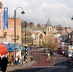
Front Street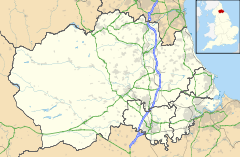
 Chester-le-Street
Chester-le-Street shown within County DurhamPopulation 23,946 (2001)[1] OS grid reference NZ270512 Unitary authority County Durham Ceremonial county County Durham Region North East Country England Sovereign state United Kingdom Post town CHESTER LE STREET Postcode district DH2, DH3 Dialling code 0191 Police Durham Fire County Durham and Darlington Ambulance North East EU Parliament North East England UK Parliament North Durham List of places: UK • England • County Durham Chester-le-Street (
 /ˈtʃɛstər liː striːt/ ches-tər lee street)[2] is a town in County Durham, England. It has a history going back to Roman times when it was called Concangis. The town is located 7 miles (11 km) south of Newcastle upon Tyne and 8 miles (13 km) west of Sunderland on the River Wear. The Parish Church of St Mary and St Cuthbert is where the body of St Cuthbert was laid to rest for some 112 years before being transferred to Durham Cathedral, and is the site of the first translation of the Gospels into English, Aldred writing the Old English gloss between the lines of the Lindisfarne Gospels there.[3]
It is a market town;[4] markets are held on Tuesdays, Fridays and Saturdays. Until 2009 the town had its own local government district. This was formed by the amalgamation in 1974 of the former Chester-le-Street Urban and Rural Districts. It was abolished in 2009 when Durham became a unitary authority as part of the 2009 structural changes to local government in England,[5][6] a move that was controversial at the time.[7][8]
Contents
History
There is evidence of Iron Age use of the River Wear near the town,[9] but the history of Chester-le-Steet starts with the Roman fort of Concangis. This was built alongside the Roman road Cade's Road (now Front Street) and close to the River Wear, around 100 A.D., and was occupied till the Romans left Britain in 410 A.D. At the time the Wear was navigable to at least Concangis, and may also have provided food for the garrisons stationed there.[10]
After the Romans left there is no record of who lived there, until 883 when a group of monks, driven out of Lindisfarne seven years earlier, stopped there to build a wooden shrine and church to St Cuthbert, whose body they had borne with them. While they were there the town was the centre of Christianity for much of the northeast, because it was the seat of the Bishop of Lindisfarne, making the church a cathedral. There the monks translated into English the Lindisfarne Gospels, which they had brought with them. They stayed for 112 years, leaving in 995 for the safer and more permanent home at Durham.[11]
The church was rebuilt in stone in 1054, and despite the loss of its bishopric seems to have retained a degree of wealth and influence. In 1080 most of the huts in the town were burned and many people killed in retaliation for the death of William Walcher, the first Prince-Bishop, at the hands of an English mob. After this devastation wrought by the Normans the region was left out of the Domesday Book; there was little left to record, and the region was by then being run from Durham by the Prince-Bishops so held little interest for London.[12]
Cade's Road did not fall out of use but was hidden beneath later roads which became the Great North Road, the main route from London and the south to Newcastle and Edinburgh. The town's location on the road played a significant role in its development, as well as its name, as inns sprung up to cater for the travelling trade: both riders and horses needed to rest on journeys usually taking days to complete. This trade reached a peak in the early 19th century as more and more people and new mail services travelled by stagecoach, before falling off with the coming of the railways. The town was bypassed when the A167 was routed around the town, and this was later supplanted by the faster A1(M).[13]
The coal industry also left its mark on the town. From the late 17th century onwards coal was dug in increasing quantities in the region. Mining was centred around the rivers, for transportation by sea to other parts of the country, and Chester-le-Street was at the centre of the coal being dug and shipped away down the Wear, so a centre of coal related communication and commerce. At the same time the growth of the mines and the influx of miners supported local businesses, not just the many inns but new shops and services, themselves bringing in more people to work in them. These people would later work in new industries established in the town to take advantage of its good communications and access to raw materials.[14]
One of the most tragic episodes in the town's history and that of the coal industry in NE England occurred during a miners' strike during the winter of 1811/12.[15] Collieries owned by the Dean and Chapter of Durham Cathedral were brought to a standstill by the strike, causing much hardship amongst the people of the town. The strike was broken on New Year's Day, 1st January 1812, when the Bishop of Durham, Shute Barrington, sent a detachment of troops from Durham Castle to force a return to work. It is thought that this uncharacteristic act by Barrington was due to pressure from the national government in Westminster who were concerned that the strike was affecting industrial output of essential armaments for the Napoleonic Wars.
The Jarrow March
On the evening of 5 October 1936 the Jarrow marchers stopped at the town centre after their first day's walk. The church hall was used to house them before they continued onward the following day.[16]
Etymology
The Romans called their fort Concangis or Concagium, a Latinisation of the Celtic name for the area, "Place of the horse people", which also gave name to the waterway through the town, Cong Burn. The precise name is uncertain as it does not appear in Roman records, but Concangis is the name most used today.[17][18]
In Anglo-Saxon times the settlement was called Cuneceastra[19] or Conceastre,[20] the name of the burn combined with the English word for a Roman fort. This shortened over time to Chester, the name used locally for the town, or Cestria in Latin.[nb 1] But "Chester" is a common name for towns in England, and in the Middle Ages "Street", for the Roman road, was added. The Universal etymological English dictionary of 1749 gives the town as "Chester upon Street" (and describes it as "a Village in the Bishoprick of Durham").[21] At some point this was shortened to the modern form.
Climate
 Flooding on Front Street in 2007
The town has a mild climate and gets well below average rainfall relative to the UK. It does though experience occasional floods. To the east of the town the Riverside cricket ground and Riverside park were built on the flood plains of the River Wear, and are often flooded when the river bursts its banks.
The town centre is subject to occasional flash flooding, usually after very heavy rain over the town and surrounding areas, if the rain falls too quickly for it to be drained away by Cong Burn. The flooding occurs at the bottom of Front Street where the Cong Burn passes under the street, after it was enclosed in concrete in 1932.[22][23]
Landmarks
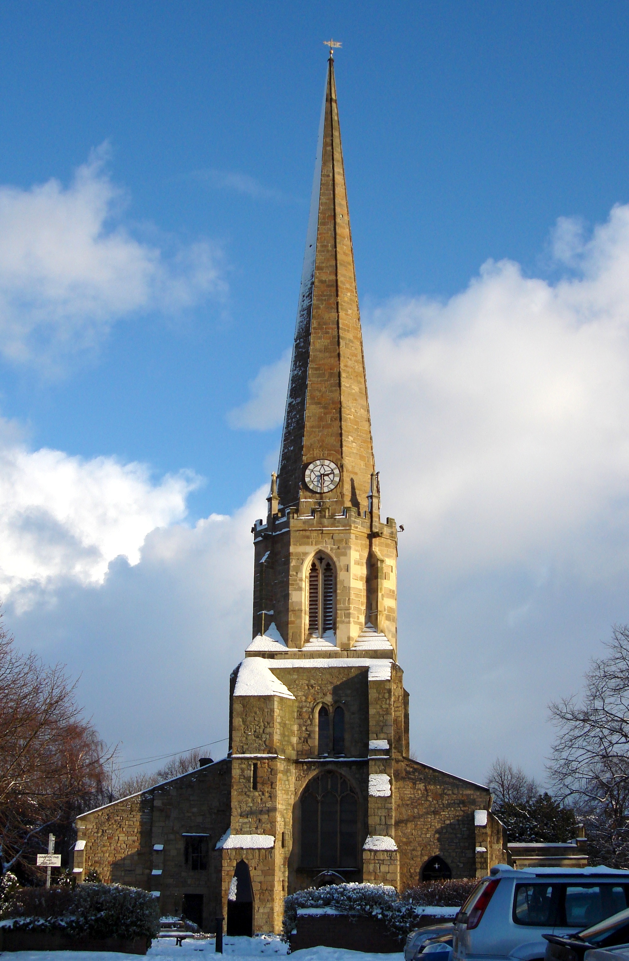
 Parish church of St Mary and St Cuthbert
John Leland described Chester-le-Street in the 1530s as: 'Chiefly one main street of very mean building in height.' Daniel Defoe echoed the sentiment.
St Mary and St Cuthbert church
Main article: St Mary and St Cuthbert, Chester-le-StreetSt Mary and St Cuthbert church possesses a rare surviving anchorage, one of the best-preserved in the country. It was built for an anchorite, an extreme form of hermit. His or her walled-up cell had only a slit to observe the altar and an opening for food, while outside was an open grave for when the occupant died. It was occupied by six anchorites from 1383 to c. 1538, and is now a museum known as the Anker's House.
The north aisle is occupied by a line of Lumley family effigies, only five genuine, assembled c. 1590. Some have been chopped-off to fit and resemble a casualty station at Agincourt, according to Sir Simon Jenkins in his England's Thousand Best Churches. It is Chester-le-Street's only Grade I listed building.[24]
Chester Burn viaduct
The viaduct to the northwest of the town centre was completed in 1868 for the North Eastern Railway, to enable trains to travel at high speed on a more direct route between Newcastle and Durham. It is over 230m long with 11 arches, now spanning a road and supermarket car-park, and is a Grade II listed building.[25]
Bethel United Reform church
The small United Reform on Low Chare, just off the main Front Street, was built in 1814 as the Bethel Congregational Chapel and remodelled in 1860. It is still in use and is a Grade II listed building.[26]
The Queens Head Hotel
The Queens Head Hotel, in a central location on Front Street, was built over 250 years ago when this road was the main route from Edinburgh and Newcastle to the south and London. It is set back from the street and is still one of the largest buildings in the street and so the town centre, and is a Grade II listed building.[27]
Chester-le-Street landmarks 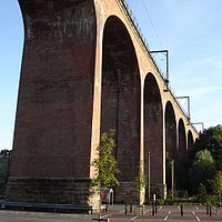 The railway viaduct over Cong Burn.
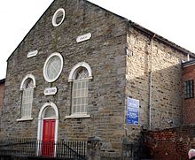 The Bethel United Reform church on Low Chare.
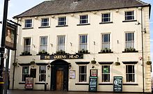 The Queens Head Hotel on Front Street.
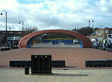 The Civic Heart Sculpture over the market place, itself built over Cong Burn.
Sport
Cricket
The Riverside Ground at Chester-le-Street is home to Durham County Cricket Club which became a first class county in 1992.
The town also has its own cricket club, Chester-le-Street Cricket Club based at the Ropery Lane ground. They are the current Champions of the North East Premier League, won the national ECB 45 over tournament in 2009 and reached the quarter final of the national 20/20 club championship in 2009.[28][29]
Rowing
 Blade colours of Chester-le-Street rowing club
Chester-le-Street rowing club is based on the River Wear near the Riverside Cricket ground.
Early football
Medieval football was once played in the town. The game was played annually on Shrove Tuesday between the "Upstreeters" and "Downstreeters". Play started at 1pm and finished at 6pm. To start the game, the ball was thrown from a window in the centre of the town and in one game more than 400 players took part. The centre of the street was the dividing line and the winner was the side where the ball was (Up or Down) at 6pm. It was played from the Middle Ages until 1932, when it was outlawed by the police and people trying to carry on the tradition were arrested.[30][31] Football support today is largely divided between Sunderland and Newcastle United.
Transport
Road
At the time of the football matches 'Front Street' was actually the A1 road from London to Edinburgh. A bypass was built in the 1950s, which still exists today as the A167. The bypass road itself was partly bypassed by, and partly incorporated in, the A1(M) motorway in the 1970s.
The northern end of Front Street used to be the start of the A6127, which is the road that would continue through Birtley, Gateshead, and eventually over the Tyne Bridge and become the A6127(M) central motorway in Newcastle upon Tyne. However, when the Gateshead-Newcastle Western Bypass of the A1(M) was opened, many roads in this area were renumbered, following the convention that roads originating between single digit A roads take their first digit from the single digit A road in an anticlockwise direction from their point of origin, and Newcastle Road, which was formerly designated A1, is now unclassified. The A6127 was renamed the A167.
Car traffic is now banned from the northern part of Front Street and it is restricted to buses, cyclists and delivery vehicles for the shops.
Rail
 Chester-le-Street Railway Station
Chester-le-Street railway station, on the East Coast Main Line of the National Rail network, between Newcastle and Durham, opened in 1868.[32] It offers local connections and cross-country train services. As of 2008[update], train operators serving the station are CrossCountry, First TransPennine Express and Northern Rail. A local independent company, Chester-le-Track, has operated the station since 1999, as an agent for Northern Spirit, Arriva Trains Northern and Northern Rail.[32][33][34]
Bus
The town is the original home of The Northern General Bus Company, nowadays Go North East, and the company still operates from the Picktree Lane Depot. It also pioneered the use of Minilink bus services in the North East in 1985
Education
Primary schools
- Bullion Lane Primary School
- Cestria Primary School
- Chester-le-Street CE (Controlled) Junior School
- Newker Primary School
- Red Rose Primary School
- South Pelaw Infant School
- St Cuthbert's RCVA Primary School
Secondary schools
- The Hermitage School
- Park View Community School[35]
Notable people
- Former England football captain Bryan Robson and his footballing brothers Justin (Newcastle United and Gateshead) and Gary (West Bromwich).
- Football manager and former England international player Colin Todd.
- Swansea City's Danny Graham.
- Leicester City's Steve Howard.
- Sunderland's Grant Leadbitter.
- Chelsea's Carl Magnay.
- Hartlepool's Michael Barron.
- Hartlepool's Michael Mackay.
- Stockport County F.C. and Wrexham F.C. footballer Peter Ward.
- Jock Purdon, the folk singer and poet, lived here for most of his life although born in Scotland.
- Bruce Welch of pop group The Shadows was brought up here.
- Gavin Sutherland, the conductor and pianist, was born and brought up here.
- Aidan Chambers children's author, Carnegie Medal and Hans Christian Andersen Award winner, was born in here.
- Paul Collingwood, England cricketer and former one-day international captain plays for Durham CCC and lives here.
- Jennifer Clark, Big Brother 9 contestant.
- Ross Pearson, UFC fighter, winner of The Ultimate Fighter 9 competition in 2009.
- Kevin "Geordie" Walker, guitarist of post-punk group Killing Joke
Twin Town
It is twinned with:
 Kamp-Lintfort in Germany.
Notes
- ^ For example the old bell in St Mary and St Cuthbert is inscribed in Latin
Magister Robertus Aschbern, Decanus Cestriae, me fecit. Hac campana data Cuthbertus sic cocitata
Master Robert Ashburn, Dean of Chester, made me. This bell given is thus named Cuthbert
References
- ^ Durham County Council – Chester le Street (this is the population for the old urban district. The larger district population is 53,100)
- ^ "How to say: Chester-le-Street". BBC News. 2006-07-24. http://www.bbc.co.uk/blogs/theeditors/2006/07/how_to_say_chesterlestreet.html. Retrieved 2009-10-20.
- ^ Selkirk (2000) pp. 339–340
- ^ "Towns in County Durham: Chester-le-Street". http://www.4durhamcounty.co.uk/towns.php?town=Chester-le-Street. Retrieved December 13, 2009.
- ^ "Unitary authority for County Durham confirmed". http://www.thenorthernecho.co.uk/news/newsediting/1884450.Unitary_authority_for_County_Durham_confirmed/. Retrieved 16 November 2009.
- ^ "Durham unitary authority approved". BBC News. 2007-07-25. http://news.bbc.co.uk/1/hi/england/wear/6915882.stm. Retrieved 16 November 2009.
- ^ "Public misled over unitary authority support – claim". http://www.thenorthernecho.co.uk/news/1436760.Public_misled_over_unitary_authority_support___claim/. Retrieved 16 November 2009.
- ^ "Thumbs down for unitary authority". BBC News. 2007-06-19. http://news.bbc.co.uk/1/hi/england/6767917.stm. Retrieved 16 November 2009.
- ^ Purdon (1992) p. 6
- ^ Selkirk (2000) pp. 45–92
- ^ Selkirk (2000) pp. 337–340
- ^ Selkirk (2000) p. 354
- ^ Purdon (1992) p.16
- ^ Selkirk (2001) pp. 391–427
- ^ William Page, "The Victoria History of the County of Durham" 3 vols (London, 1907), II.153
- ^ Matt Perry (2005). The Jarrow crusade: protest and legend. p. 31. ISBN 1873757603. http://books.google.co.uk/books?id=LVKyAAAAIAAJ.
- ^ Selkirk (2001) p. 45
- ^ Purdon (1992) p. 8
- ^ Purdon (1992) p. 10
- ^ Selkirk (2000) p. 337
- ^ Bailey, Nathan (1749). An universal etymological English dictionary. p. 168. http://books.google.com/books?id=UucIAAAAQAAJ.
- ^ "The Great Flood". http://www.communigate.co.uk/ne/chesterlestreetheritage/page17.phtml. Retrieved 12 March 2010.
- ^ "Market Refurbishment". http://www.communigate.co.uk/ne/chesterlestreetheritage/page25.phtml. Retrieved 12 March 2010.
- ^ "Chester-le-Street, Church of St Mary & St Cuthbert; Listed building (Chester-le-Street)". Durham County Council. http://www.keystothepast.info/K2P.nsf/K2PDetail?readform&PRN=D11004. Retrieved September 28, 2010.
- ^ "Railway Viaduct Over Chester Burn; Listed building (Chester-le-Street)". Durham County Council. http://www.keystothepast.info/K2P.nsf/K2PDetail?readform&PRN=D11031. Retrieved September 28, 2010.
- ^ "Chester-le-Street, United Reformed Church; Listed building (Chester-le-Street)". Durham County Council. http://www.keystothepast.info/K2P.nsf/K2PDetail?readform&PRN=D11005. Retrieved September 28, 2010.
- ^ "Queens Head Hotel; Listed building (Chester-le-Street)". Durham County Council. http://www.keystothepast.info/K2P.nsf/K2PDetail?readform&PRN=D11046. Retrieved September 28, 2010.
- ^ "Chester-le-Street – Play-Cricket". http://cles.play-cricket.com/home/home.asp. Retrieved February 10, 2010.
- ^ "Chester-le-Street Cricket Club". http://www.chesterlestreet-cc.com/. Retrieved February 10, 2010.
- ^ Purdon (1992) pp. 21–22
- ^ "Shrove Tide Football". http://www.communigate.co.uk/ne/chesterlestreetheritage/page24.phtml. Retrieved 12 November 2009.
- ^ a b "Rail Ticketing Guide". Chester-le-Track. April 2002. http://www.chester-le-track.co.uk/htm/ticketing_guide.htm. Retrieved 2008-04-15.
- ^ "Station Facilities: Chester-le-Street (CLS)". National Rail. 2008-03-31. http://www.nationalrail.co.uk/stations/CLS.html. Retrieved 2008-04-15.
- ^ "Chester-le-Street Gets Intercity Station". Durham Business Club. May 2004. http://www.durhambusinessclub.co.uk/news/article/headline=/rowid=10. Retrieved 2008-04-15.[dead link]
- ^ "Chester-le-Street District Schools". http://nd.durham.gov.uk/durhamcc/directory.nsf/vschches?openview&count=300. Retrieved January 10, 2010.
Bibliography
- Selkirk, Raymond (2000). Chester-le-Street & Its Place in History. Birtley, County Durham: Casdec Print & Design Centre. ISBN 1-900456-05-2.
- Purdon, Gavin (1992). Chester-le-Street and district – The people and the place.
External links
- Chester-le-Live community website
- Cestria Primary School
- Chester-le-Street CE(Controlled) Junior
- Chester-le-Street Heritage Group local history society
- Chester-le-Street Railway Station
- Chester-le-Street Scout District
- Chester-le-Street shops
- Chester-le-Street Town Football Club
- Concangis Roman fort or castra
- Durham County Cricket Club
- The Hermitage School
- Newker Primary
- Parish Church of St Mary and St Cuthbert
- Parkview Community School
- Red Rose Primary School
- St Cuthberts RC Primary
Unitary authorities Major settlements Barnard Castle · Billingham · Bishop Auckland · Chester-le-Street · Chilton · Consett · Crook · Darlington · Durham · Eaglescliffe · Easington · Easington Colliery · Ferryhill · Hartlepool · Middleton-in-Teesdale · Newton Aycliffe · Peterlee · Seaham · Sedgefield · Shildon · Spennymoor · Stanhope · Stanley · Stockton-on-Tees · Tow Law · Willington · Wolsingham
See also: List of civil parishes in County DurhamTopics Categories:- Market towns in County Durham
- Towns in County Durham


Wikimedia Foundation. 2010.