- Concangis
-
Coordinates: 54°51′24″N 1°34′20″W / 54.85659°N 1.572263°W
Concangis 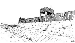
What the early defences at Concangis may have looked like
This article is part of the series on:
Military of ancient Rome (portal)
753 BC – AD 476Structural history Roman army (unit types and ranks, legions, auxiliaries, generals) Roman navy (fleets, admirals) Campaign history Lists of wars and battles Decorations and punishments Technological history Military engineering (castra, siege engines, arches, roads) Political history Strategy and tactics Infantry tactics Frontiers and fortifications (limes, Hadrian's Wall) 
 Concangis
 Concangis shown within County Durham
OS grid reference NZ270512 List of places: UK • England • County Durham Concangis (or Chester-le-Street Roman Fort) was an auxiliary castra close to Dere Street, in the Roman province of Britannia Inferior (Upper Britain). Its foundations are located at Chester-le-Street, County Durham, England. It is situated 6 miles (10 km) north of Durham and 8 miles (13 km) south of Newcastle upon Tyne.[1]
Contents
History
The Roman fort of Concangis is located east of the forts of Longovicium (Lanchester) and Vindomora (Ebchester) and 8 miles (13 km) south from Pons Aelius (Newcastle upon Tyne). It is east of the main Roman road of Dere Street that connect other forts nearby the wall and beyond to Eboracum (York). The fort was situated on another road, Cade's Road, leading from York to Pons Aelius.[2] It is also believed it may have joined Dere Street through a branch road heading west connected to Longovicium (situated on Dere Street), but this has yet to be discovered. The discovery by Raymond Selkirk of an abutment on the Cong Burn stream suggests a bridge was built there and connected this fort with the one at Vindomora (Ebchester) to the west.
 What remains to be seen in Low Chare
It is listed on both the 4th/5th century Notitia Dignitatum and the 7th century Ravenna Cosmography. The name Concangis is Celtic rather than Roman and is thought to have meant something like 'the horse people', perhaps due to a nearby tribe.[3]
The fort is situated on a high bluff, overlooking the valleys of the Wear to the east and the Cong Burn to the north, the fort is in the sort of position frequently favoured by Roman military surveyors. The road north to Pons Aelius passes west of the fort and made monitoring of traffic easy. The fort covered roughly six and a half acres, and was built first in turf and timber probably in 70's AD by the Legio VIIII Hispana (Ninth Hispanic Legion), and later in stone by the Legio II Augusta (The Second Augustan Legion), probably during the early 2nd century, coinciding with the construction of Hadrian's Wall, which was also built by Legio II.[2]
Excavations were carried out in 1978 and in 1990/1991. Unfortunately much of the fort is located beneath the town of Chester-le-Street so little remains to be seen, except for a portion of the excavated officer's quarters left on display. Finds included pottery, fine table wares, coins, animal bones, a cheese press and curiously even a tile with a dog's footprint on it.[4] Altars found range from the war god Mars and the sun god Apollo, to Celtic and German ones such as Digenis and Vitiris. The large (3 out of 8) number of altars dedicated to patron deities concerned with the wellbeing of veteran soldiers would seem to suggest the inhabitants of Concangis had a high proportion of ex-military men. Two large stones in the buttress of the parish church of St Mary and St Cuthbert have lewis holes which indicate they were recycled from the Roman fort.[5]
 Tile with dog's print on it
Garrison
 Reconstruction of the Officers Quarters
A construction inscription attests the Legio II Augusta as having built/rebuilt the fort, but as is usual, this gives no evidence as to who occupied it as Legionaries only built the fortifications, it was the Auxilia that garrisoned it. An incomplete inscription mentions an Alae Antoninae (Antonian Wing) possibly on routine patrols and on restoration work on an aqueduct and latrines. The poor state of the inscription makes it impossible to accurately identify the unit, but based on finds nearby and units with similar names, it can be deduced the unit present was the Ala Secundae Asturum Antoniniana (Second Wing of Antoninian's Asturians). This unit was present for emperor's Severus campaigns in Caledonia and was also present at other forts such as Lindum (Lincoln).[2]
A tile with the initials NV seems to suggest the Numeri Vigilum was present here during the 4th century AD. It was also listed as Praefectus Numeri Vigilum Concangios (The Prefect of the Company of Watchmen from Concangis) under the Duke of the Britains.
Gallery
-

Remains of cheese press
-

Aerial view of officers quarters
-

View of latrine
-

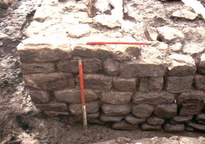
Stone remains of north wall
-

Stone remains of south wall
See also
References
- ^ Welcome to stimpson-corner.co.uk
- ^ a b c Concangis
- ^ Concangis: the Background
- ^ Concangis: the Excavations in Church Chare
- ^ Selkirk, Raymond (2000). Chester-le-Street & Its Place in History. Birtley, County Durham: Casdec Print & Design Centre. p. 51. ISBN 1-900456-05-2.
External links
Categories:- Roman forts in England
- Roman sites in County Durham
- English Heritage sites in County Durham
- Visitor attractions in County Durham
-


Wikimedia Foundation. 2010.