- Melbourne tram route 1
-
East Coburg - South Melbourne Beach 
Route Information Route Number 1 Number of stops 52 Timetables Link Route Map Link Zone Location Zone 1 Entire route Tram route 1 is a public transport service in Melbourne, Victoria, Australia. It runs from the terminus at Nicholson Street and Bell Street in East Coburg to the corner of Victoria Avenue and Beaconsfield Parade in Albert Park.
Like most tram routes in Melbourne, it is entirely within Metcard/myki ticketing Zone 1.
A rare 1970s silk screen print by Canadian-Australian artist Ed Goodson, was titled Tram No. 1 South Melbourne Beach.
Contents
History
The origins of route 1 lie in separate tram lines, a cable tram from Collins Street to South Melbourne Beach, a cable tram along Swanston Street and St Kilda Road, an electric line from Queensberry Street to East Coburg and a section of track between Clarendon Street and St Kilda Road.
Cable trams first travelled from Queensberry Street, Carlton to Milton Street, Balaclava, on 11 October 1888, with the line opened by the Melbourne Tramway and Omnibus Company.[1]
A cable tram between Collins Street and South Melbourne Beach, travelling Market Street, Queens Bridge Street, City Road, Clarendon Street, Park Street, Montague Street, Bridport Street and Victoria Avenue was opened on 17 June 1890, by the Melbourne Tramway and Omnibus Company.[1]
The Melbourne, Brunswick and Coburg Tramways Trust started building its tramway system in June 1914, on 31 October 1916 East Coburg was connected to Melbourne at Queensberry Street along Nicholson Street, Holmes Street, Lygon Street, Elgin Street and Madeline Street - as the section of Swanston Street north of Victoria Street was originally known.[2]
The Melbourne and Metropolitan Tramways Board constructed a track connecting Clarendon Street and St Kilda Road along Sturt Street, Eastern Road, Heather Street and Park Street, which opened on 31 October 1925.[3]
The Melbourne and Metropolitan Tramways Board converted the Swanston Street/St Kilda Road cable line to electric traction between 1924 and 1926, with electric trams able to run the entire length on 29 August 1926.[3]
The Market Street cable lines were mainly converted - the Port Melbourne cable tram line, including the Hannah Street (now Kings Way) to Clarendon Street section of City Road was abandoned in favour of buses - to electric traction by the Melbourne and Metropolitan Tramways Board, with the first service to South Melbourne Beach on 25 July 1937.[4]
As part of the City Road and St Kilda Road separation project, the northern most section of track along Sturt Street was relocated to Nolan Street (now Southbank Boulevard) on 16 March 1970.[5]
Route
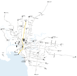
Route 1 

East Coburg Stop 135 
Rennie St 131 Moreland Rd Route 8 129 
Brunswick Albion St 127 Blyth St 125 Glenlyon Rd 122 Brunswick Rd 120 Carlton Princes St 114 Lytton St 113 Elgin St 112 Melbourne University 1 City La Trobe St Melbourne Central Station Routes 24, 30, City Circle 8 Lonsdale St 9 Bourke St Routes 86, Collins St Routes 11, 42, 48, 109, 112 11 Federation Square Flinders St Station Routes 70, Arts Precinct Routes 3/3a, 5, 6, 8, 16, 64, 67, 72 14 Kings Way Route 55 20 South Melbourne Clarendon St Route 112 24 Ferrars St 26 Bridport St 28 Richardson St 30 
South Melbourne Beach 32 Not all stops are shown, refer to timetable for full list of stops.
 B2 class tram on route 1 in Swanston Street
Route 1 runs from East Coburg, travelling south on Nicholson Street from Bell Street through Coburg to Brunswick East where Nicholson Street becomes Holmes Road. It continues south to Albion Street where it doglegs into Lygon Street, Brunswick East, continuing south through Carlton North and Carlton, turning west into Elgin St and south into Swanston Street at Melbourne University.
It passes through the CBD on Swanston Street, passing Royal Melbourne Institute of Technology, Melbourne Central railway station, State Library of Victoria, Melbourne Town Hall, City Square, St Paul's Cathedral, Flinders Street railway station, Federation Square and Birrarung Marr.
Crossing the Yarra River into Southbank along St Kilda Road, it passes The Arts Centre and National Gallery of Victoria before turning west into Southbank Boulevard, quickly turning south onto Sturt Street, passing the Melbourne Recital Hall and Victorian College of the Arts. It briefly travels south on Eastern Road and Heather Street to Park Street, South Melbourne where it travels west to Montague Street Albert Park, and travels south, turning west into Bridport Street and continuing to its terminus in Victoria Avenue at Beaconsfield Parade.
Operation
Route 1 is run from Brunswick depot[6] and is predominantly run with Z3 class and B2 class trams.
Maps and Timetables
- Official timetables
- Official route map
- Official tram network map
- Tram and train network map from railmaps.com.au
See also
- Trams in Melbourne
- Transportation in Australia
References
- ^ a b "Melbourne Tramway and Omnibus Company Limited", TMSV Running Journal Vol 9 No 3, page 16, http://www.tramway.org.au/runningjournal/rj_vol9_no3.pdf, retrieved 2011-10-16
- ^ "The Melbourne, Brunswick and Coburg Tramways Trust", TMSV Running Journal, http://www.tramway.org.au/reflections.php?p=the_melbourne_brunswick_and_coburg_tramways_trust, retrieved 2011-09-25
- ^ a b "Milestones, 1921 - 1930", Yarra Trams, http://www.yarratrams.com.au/desktopdefault.aspx/tabid-155/173_read-882, retrieved 2011-09-26
- ^ "Milestones, 1931 - 1940", Yarra Trams, http://www.yarratrams.com.au/desktopdefault.aspx/tabid-155/173_read-881, retrieved 2011-09-26
- ^ "Milestones, 1961 - 1970", Yarra Trams, http://www.yarratrams.com.au/desktopdefault.aspx/tabid-155/173_read-878, retrieved 2011-09-26
- ^ "Brunswick Depot", VICSIG, http://www.vicsig.net/index.php?page=trams&depot=brunswick, retrieved 2011-09-26
Trams in Melbourne - Yarra Trams Routes Current Tram Fleet W • Z • A • B • C • C2 • DOperator KDR Melbourne (Yarra Trams)Former operators Prahran and Malvern • Hawthorn • Melbourne, Brunswick and Coburg • Fitzroy, Northcote and Preston • Footscray • Northcote Municipality • North Melbourne Electric Tramway and Lighting Company • Melbourne and Metropolitan Tramways Board • Victorian Railways • M>Tram • Transdev TSLTourist services Tram depots Brunswick • Camberwell • East Preston • Essendon • Glenhuntly • Hawthorn • Kew • Malvern • North Fitzroy • Preston Workshops • Newport Workshops • Southbank • South MelbourneMiscellaneous Categories:- Tram routes in Melbourne


Wikimedia Foundation. 2010.