- National Register of Historic Places listings in Brown County, Ohio
-
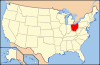
 Location of Brown County in Ohio
This is a list of the National Register of Historic Places listings in Brown County, Ohio.
This is intended to be a complete list of the properties and districts on the National Register of Historic Places in Brown County, Ohio, United States. The locations of National Register properties and districts for which the latitude and longitude coordinates are included below, may be seen in a Google map.[1]
There are 26 properties and districts listed on the National Register in the county, including 3 National Historic Landmarks.
-
- This National Park Service list is complete through NPS recent listings posted November 10, 2011.[2]
Current listings
[3] Landmark name [4] Image Date listed Location City or town Summary 1 Aberdeen Mound July 15, 1974 Along High Street at the eastern end of the village
38°39′11″N 83°45′32″W / 38.65306°N 83.75889°W[5]Aberdeen 2 Bailey-Thompson House November 7, 1976 112 N. Water St.
38°51′59″N 83°54′05″W / 38.866389°N 83.901389°WGeorgetown 3 Dr. Philip Buckner House and Barn March 30, 1978 610 S. Main St.
38°51′39″N 83°54′18″W / 38.860833°N 83.905°WGeorgetown 4 Burgett House and Barn November 14, 1978 West of Ripley on White Rd.
38°46′41″N 83°53′44″W / 38.778056°N 83.895556°WUnion Township 5 Eagle Creek Covered Bridge December 6, 1975 3 mi (4.8 km) south of Decatur on State Route 763
38°46′11″N 83°42′54″W / 38.769722°N 83.715°WByrd Township 6 Eagle Township Works I Mound September 10, 1971 Address Restricted Eagle Township Near Fincastle 7 Farmers Branch, State Bank of Ohio April 21, 1983 14 Front St.
38°44′44″N 83°50′48″W / 38.745556°N 83.846667°WRipley 8 Georgetown Historic District 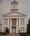
May 23, 1978 Roughly bounded by Water Alley, Pleasant, Short, and State Sts.
38°51′58″N 83°54′15″W / 38.866043°N 83.904068°WGeorgetown 9 Georgetown Public School January 25, 1991 307 W. Grant Ave.
38°51′56″N 83°54′26″W / 38.865556°N 83.907222°WGeorgetown 10 Ulysses S. Grant Boyhood Home 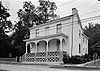
October 8, 1976 219 E. Grant Ave.
38°51′58″N 83°54′08″W / 38.866111°N 83.902222°WGeorgetown 11 Higginsport School January 14, 2000 Junction of Jackson and Gaines Sts.
38°47′27″N 83°58′06″W / 38.790833°N 83.968333°WHigginsport 12 Henry Martin Farm August 15, 1975 2 mi (3.2 km) north of Ripley on U.S. Route 68
38°46′43″N 83°51′24″W / 38.778611°N 83.856667°WUnion Township 13 Maysville-Aberdeen Bridge 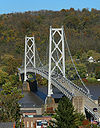
June 30, 1983 Spans the Ohio River between Aberdeen and Maysville, Kentucky
38°39′19″N 83°45′27″W / 38.655278°N 83.7575°WAberdeen Extends into Mason County, Kentucky 14 Mount Orab Station October 14, 1975 N. High and Front Sts.
39°01′45″N 83°55′09″W / 39.029167°N 83.919167°WMount Orab 15 Daniel Murphy Log House June 17, 1982 Anderson State Rd., southwest of St. Martin
39°12′19″N 83°54′24″W / 39.205278°N 83.906667°WPerry Township 16 John P. Parker House 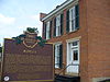
January 7, 1980 300 Front St.
38°45′00″N 83°50′57″W / 38.75°N 83.849167°WRipley Designated a National Historic Landmark in 1997 17 Pisgah Christian Church November 21, 1980 Northwest of Ripley on Pisgah Rd.
38°46′57″N 83°52′48″W / 38.7825°N 83.88°WUnion Township 18 John Rankin House 
November 10, 1970 East of Ripley, Liberty Hill
38°45′04″N 83°50′32″W / 38.751111°N 83.842222°WUnion Township 19 Red Oak Presbyterian Church June 17, 1982 Cemetery Rd., north of Ripley
38°47′43″N 83°47′44″W / 38.795278°N 83.795556°WUnion Township 20 Ripley Historic District 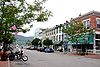
March 7, 1985 Roughly bounded by Main, Front, 2nd, 3rd and 4th Sts.
38°44′45″N 83°50′41″W / 38.74585°N 83.844652°WRipley 21 Stonehurst October 10, 1975 2 mi (3.2 km) north of Ripley off U.S. Route 68
38°46′56″N 83°51′22″W / 38.782222°N 83.856111°WUnion Township 22 Sutton House March 25, 1977 0.3 mi (0.48 km) east of Decatur on State Route 125
38°48′49″N 83°41′54″W / 38.813611°N 83.698333°WByrd Township 23 Thompson Farm January 1, 1976 West of Georgetown off State Route 221
38°51′58″N 83°55′23″W / 38.866111°N 83.923056°WPleasant Township 24 Thompson-Bullock House 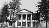
February 23, 1978 West of Georgetown off State Route 221
38°51′59″N 83°55′23″W / 38.866389°N 83.923056°WPleasant Township 25 Thumann Log House March 27, 1975 1 mi (1.6 km) south of St. Martin at the junction of U.S. Route 50 and State Route 251
39°11′28″N 83°53′51″W / 39.191111°N 83.8975°WPerry Township 26 Ursuline Center June 29, 1976 Northeast of Fayetteville off State Route 251
39°12′35″N 83°53′15″W / 39.209722°N 83.8875°WPerry Township See also
References
- ^ The latitude and longitude information provided in this table was derived originally from the National Register Information System, which has been found to be fairly accurate for about 99% of listings. For about 1% of NRIS original coordinates, experience has shown that one or both coordinates are typos or otherwise extremely far off; some corrections may have been made. A more subtle problem causes many locations to be off by up to 150 yards, depending on location in the country: most NRIS coordinates were derived from tracing out latitude and longitudes off of USGS topographical quadrant maps created under the North American Datum of 1927, which differs from the current, highly accurate WGS84 GPS system used by Google maps. Chicago is about right, but NRIS longitudes in Washington are higher by about 4.5 seconds, and are lower by about 2.0 seconds in Maine. Latitudes differ by about 1.0 second in Florida. Some locations in this table may have been corrected to current GPS standards.
- ^ "National Register of Historic Places: Weekly List Actions". National Park Service, United States Department of the Interior. Retrieved on November 10, 2011.
- ^ Numbers represent an ordering by significant words. Various colorings, defined here, differentiate National Historic Landmark sites and National Register of Historic Places Districts from other NRHP buildings, structures, sites or objects.
- ^ "National Register Information System". National Register of Historic Places. National Park Service. . http://nrhp.focus.nps.gov/natreg/docs/All_Data.html.
- ^ Location derived from Mills, William C. Archeological Atlas of Ohio. Columbus: Ohio State Archeological and Historical Society, 1914, page 8 and plate 8. The NRIS lists the site as "Address Restricted".
National Register of Historic Places in Ohio Lists by county Adams • Allen • Ashland • Ashtabula • Athens • Auglaize • Belmont • Brown • Butler • Carroll • Champaign • Clark • Clermont • Clinton • Columbiana • Coshocton • Crawford • Cuyahoga • Darke • Defiance • Delaware • Erie • Fairfield • Fayette • Franklin • Fulton • Gallia • Geauga • Greene • Guernsey • Hamilton • Hancock • Hardin • Harrison • Henry • Highland • Hocking • Holmes • Huron • Jackson • Jefferson • Knox • Lake • Lawrence • Licking • Logan • Lorain • Lucas • Madison • Mahoning • Marion • Medina • Meigs • Mercer • Miami • Monroe • Montgomery • Morgan • Morrow • Muskingum • Noble • Ottawa • Paulding • Perry • Pickaway • Pike • Portage • Preble • Putnam • Richland • Ross • Sandusky • Scioto • Seneca • Shelby • Stark • Summit • Trumbull • Tuscarawas • Union • Van Wert • Vinton • Warren • Washington • Wayne • Williams • Wood • Wyandot
Lists by city Other lists Municipalities and communities of Brown County, Ohio Villages Aberdeen | Fayetteville | Georgetown | Hamersville | Higginsport | Mount Orab | Ripley | Russellville | Sardinia‡ | St. Martin

Townships Unincorporated
communitiesFootnotes ‡This populated place also has portions in an adjacent county or counties
Categories:- National Register of Historic Places in Ohio by county
- Brown County, Ohio
-


Wikimedia Foundation. 2010.