- National Register of Historic Places listings in Ross County, Ohio
-
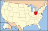
 Location of Ross County in Ohio
This is a list of the National Register of Historic Places listings in Ross County, Ohio.
This is intended to be a complete list of the properties and districts on the National Register of Historic Places in Ross County, Ohio, United States. The locations of National Register properties and districts for which the latitude and longitude coordinates are included below, may be seen in a Google map.[1]
There are 42 properties and districts listed on the National Register in the county, including 2 National Historic Landmarks. Another property was once listed but has been removed.
-
- This National Park Service list is complete through NPS recent listings posted November 10, 2011.[2]
Current listings
[3] Landmark name [4] Image Date listed Location City or town Summary 1 Adena (Thomas Worthington House) 
November 10, 1970 Box 831 Adena Rd.
39°21′18″N 83°00′49″W / 39.355°N 83.013611°WChillicothe 2 Adena Mound 
June 5, 1975 947-999 Orange St.
39°21′20″N 83°0′28.8″W / 39.35556°N 83.008°W[5]Chillicothe Levelled after excavation[6] 3 Levi Anderson House December 12, 1976 West of Chillicothe on Anderson Station Rd.
39°21′38″N 83°04′32″W / 39.360556°N 83.075556°WUnion Township 4 Howard Baum Site (33RO270) August 14, 1986 South of Bourneville along Paint Creek
39°15′53″N 83°9′12″W / 39.26472°N 83.15333°W[7]Twin Township 5 Austin Brown Mound February 15, 1974 Near Brown Chapel, northwest of Chillicothe
39°28′56″N 83°5′53.5″W / 39.48222°N 83.098194°W[8]Scioto Township 6 Buchwalter House-Applethorpe Farm 
May 26, 1983 292 Whissler Rd., north of Hallsville
39°27′10″N 82°49′14″W / 39.452778°N 82.820556°WColerain Township 7 T.C. Campbell Mound July 15, 1974 Southwest of Bainbridge[5] Paxton Township 8 Canal Warehouse 
April 24, 1973 Main and Mulberry Sts.
39°20′03″N 82°58′44″W / 39.334167°N 82.978889°WChillicothe 9 Cedar-Bank Works 
February 15, 1974 Eastern bank of the Scioto River, north of Chillicothe
39°24′4″N 82°58′36″W / 39.40111°N 82.97667°W[7]Green Township 10 Chillicothe Business District 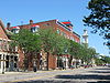
June 11, 1979 Roughly bounded by Water, 4th, Walnut and Hickory Sts.
39°20′03″N 82°58′56″W / 39.334167°N 82.982222°WChillicothe 11 Chillicothe Water and Power Company Pumping Station 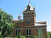
November 15, 1979 Enderlin Circle
39°20′22″N 82°58′55″W / 39.339444°N 82.981944°WChillicothe 12 Chillicothe's Old Residential District 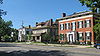
November 28, 1973 Roughly bounded by 4th, S. Mulberry, S. Walnut and 7th Sts.
39°19′43″N 82°59′04″W / 39.328611°N 82.984444°WChillicothe 13 Frankfort Works Mound 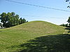
May 17, 1973 Western side of Frankfort
39°24′16.68″N 83°11′14.19″W / 39.4046333°N 83.187275°W[9]Frankfort 14 Gartner Mound and Village Site 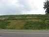
July 27, 2005 Along the Scioto River, 6 miles north of Chillicothe
39°24′45.5″N 82°59′0″W / 39.412639°N 82.983333°W[7]Green Township 15 Grandview Cemetery 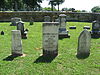
December 19, 1978 240 S. Walnut St.
39°19′28″N 82°59′10″W / 39.324444°N 82.986111°WChillicothe 16 Great Seal Park Archeological District 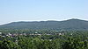
December 2, 1974 In Great Seal State Park, 3 miles from Chillicothe
39°22′12″N 82°56′24″W / 39.37°N 82.94°W[10]Springfield Township 17 Dr. John Harris Dental School 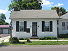
July 23, 1973 Main St.
39°13′38″N 83°16′21″W / 39.227222°N 83.2725°WBainbridge 18 Higby House November 29, 1979 South of Chillicothe on Three Locks Rd.
39°11′50″N 82°51′58″W / 39.197222°N 82.866111°WFranklin Township 19 High Banks Works 
July 16, 1973 Eastern bank of the Scioto River, southeast of Chillicothe
39°17′48″N 82°55′3″W / 39.29667°N 82.9175°W[11]Liberty Township 20 Highbank Farm October 20, 1980 Southeast of Chillicothe on U.S. Route 35
39°16′15″N 82°53′49″W / 39.270833°N 82.896944°WLiberty Township 21 Hopeton Earthworks 
October 15, 1966 On a terrace of the Scioto River at Hopetown, 1 mile east of the main Mound City group
39°23′11″N 82°58′45″W / 39.38639°N 82.97917°W[12]Springfield Township 22 Hopewell Mound Group 
February 12, 1974 Northern bank of the North Fork of Paint Creek
39°21′40″N 83°5′24″W / 39.36111°N 83.09°W[7]Union Township 23 Kinzer Mound January 17, 1974 Address Restricted South Salem 24 Henry Mace House February 12, 1998 17380 State Route 104, N.
39°23′32″N 83°00′45″W / 39.392222°N 83.0125°WUnion Township 25 Mary Worthington Macomb House 
April 26, 1976 490 S. Paint St.
39°19′19″N 82°58′48″W / 39.321944°N 82.98°WChillicothe 26 McCafferty Run Farmstead September 3, 2004 17114 and 17226 State Route 104
39°23′25″N 83°00′43″W / 39.390278°N 83.011944°WUnion Township 27 Charles Metzger Mound June 18, 1973 2 miles southwest of Yellow Bud, on a hilltop above Deer Creek
39°27′51″N 83°3′18.75″W / 39.46417°N 83.0552083°W[13]Union Township 28 Mound City Group National Monument 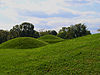
October 15, 1966 North of Chillicothe
39°22′33″N 83°0′16″W / 39.37583°N 83.00444°WUnion Township 29 Mountain House 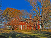
December 29, 1978 Highland Ave.
39°19′55″N 82°59′29″W / 39.331944°N 82.991389°WChillicothe 30 Oak Hill 
April 3, 1973 Dun Rd.
39°19′35″N 83°01′28″W / 39.326389°N 83.024444°WScioto Township 31 Renick House, Paint Hill 
May 9, 1973 17 Mead Dr.
39°19′24″N 82°59′26″W / 39.323333°N 82.990556°WChillicothe 32 Seip Earthworks and Dill Mounds District 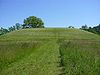
August 13, 1974 Southern side of U.S. Route 50, 3 miles east of Bainbridge
39°14′16″N 83°13′12.5″W / 39.23778°N 83.220139°W[14]Paxton Township 33 Seip House 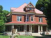
May 12, 1981 345 Allen Ave.
39°20′30″N 82°59′37″W / 39.341667°N 82.993611°WChillicothe 34 South Salem Academy 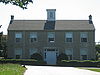
February 23, 1979 Church St.
39°20′10″N 83°18′38″W / 39.336111°N 83.310556°WSouth Salem 35 South Salem Covered Bridge 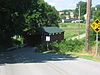
March 4, 1975 West of South Salem on Lower Twin Rd. across Buckskin Creek
39°20′03″N 83°18′52″W / 39.334167°N 83.314444°WBuckskin Township 36 Spruce Hill Works 
February 23, 1972 On a hill overlooking Bourneville
39°16′33″N 83°8′15″W / 39.27583°N 83.1375°W[7]Twin Township 37 David Stitt Mound November 9, 1972 Address Restricted Chillicothe 38 Story Mound State Memorial 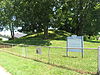
March 7, 1973 East of the junction of Cherokee and Delano Streets
39°20′31″N 82°59′58″W / 39.341944°N 82.999444°WChillicothe 39 Tanglewood 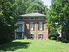
June 20, 1979 177 Belleview Ave.
39°19′39″N 82°59′19″W / 39.3275°N 82.988611°WChillicothe 40 Vanmeter Church Street House 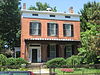
February 21, 1979 178 Church St.
39°20′10″N 82°59′29″W / 39.336111°N 82.991389°WChillicothe 41 Anthony and Susan Cardinal Walke House 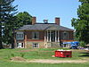
February 21, 2007 381 Western Ave.
39°20′06″N 82°59′55″W / 39.335°N 82.998611°WChillicothe 42 Wesley Chapel 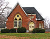
February 2, 1979 Off U.S. Route 23 at Hopetown
39°22′40″N 82°58′22″W / 39.377778°N 82.972778°WSpringfield Township Former listing
[3] Landmark name Image Date listed Location City or town Summary 1 Kendrick-Barrett House 
November 25, 1977 475 Western Ave.
39°20′3.6″N 83°0′9″W / 39.334333°N 83.0025°WChillicothe Listed on March 14, 1973 See also
References
- ^ The latitude and longitude information provided in this table was derived originally from the National Register Information System, which has been found to be fairly accurate for about 99% of listings. For about 1% of NRIS original coordinates, experience has shown that one or both coordinates are typos or otherwise extremely far off; some corrections may have been made. A more subtle problem causes many locations to be off by up to 150 yards, depending on location in the country: most NRIS coordinates were derived from tracing out latitude and longitudes off of USGS topographical quadrant maps created under the North American Datum of 1927, which differs from the current, highly accurate WGS84 GPS system used by Google maps. Chicago is about right, but NRIS longitudes in Washington are higher by about 4.5 seconds, and are lower by about 2.0 seconds in Maine. Latitudes differ by about 1.0 second in Florida. Some locations in this table may have been corrected to current GPS standards.
- ^ "National Register of Historic Places: Weekly List Actions". National Park Service, United States Department of the Interior. Retrieved on November 10, 2011.
- ^ a b Numbers represent an ordering by significant words. Various colorings, defined here, differentiate National Historic Landmark sites and National Register of Historic Places Districts from other NRHP buildings, structures, sites or objects.
- ^ "National Register Information System". National Register of Historic Places. National Park Service. . http://nrhp.focus.nps.gov/natreg/docs/All_Data.html.
- ^ a b Location derived from its Federal Register notice; the NRIS lists the site as "Address Restricted"
- ^ Adena Mound, Ohio Historical Society, 2004. Accessed 2009-10-17.
- ^ a b c d e Location derived from Mills, William C. Archeological Atlas of Ohio. Columbus: Ohio State Archeological and Historical Society, 1914, pages 71-71A and plate 71. The NRIS lists the site as "Address Restricted".
- ^ Location derived from Ohio Archaeological and Historical Quarterly, vol. 7. Columbus: Ohio State Archaeological and Historical Society, 1899, 137. Accessed 2009-10-19. The NRIS lists the site as "Address Restricted"
- ^ Location derived from the "Indian Mound" marked on USGS maps of Frankfort; the NRIS lists the site as "Address Restricted"
- ^ Location derived from Moorehead, Warren King. Primitive Man in Ohio. New York: Knickerbocker, 1892, 145. Accessed 2009-10-20. The NRIS lists the site as "Address Restricted".
- ^ Location derived from this National Park Service document; the NRIS lists the site as "Address Restricted"
- ^ Location derived from this National Park Service webpage; the NRIS lists the site as "Address Restricted"
- ^ Location derived from Proceedings of the Academy of Natural Sciences of Philadelphia, Academy of Natural Sciences of Philadelphia, 1894, 314. Accessed 2009-10-19. The NRIS lists the site as "Address Restricted"
- ^ Location derived from DeLorme. Ohio Atlas & Gazetteer. 7th ed. Yarmouth: DeLorme, 2004, 77. ISBN 0-89933-281-1. The NRIS lists the site as "Address Restricted".
National Register of Historic Places in Ohio Lists by county Adams • Allen • Ashland • Ashtabula • Athens • Auglaize • Belmont • Brown • Butler • Carroll • Champaign • Clark • Clermont • Clinton • Columbiana • Coshocton • Crawford • Cuyahoga • Darke • Defiance • Delaware • Erie • Fairfield • Fayette • Franklin • Fulton • Gallia • Geauga • Greene • Guernsey • Hamilton • Hancock • Hardin • Harrison • Henry • Highland • Hocking • Holmes • Huron • Jackson • Jefferson • Knox • Lake • Lawrence • Licking • Logan • Lorain • Lucas • Madison • Mahoning • Marion • Medina • Meigs • Mercer • Miami • Monroe • Montgomery • Morgan • Morrow • Muskingum • Noble • Ottawa • Paulding • Perry • Pickaway • Pike • Portage • Preble • Putnam • Richland • Ross • Sandusky • Scioto • Seneca • Shelby • Stark • Summit • Trumbull • Tuscarawas • Union • Van Wert • Vinton • Warren • Washington • Wayne • Williams • Wood • Wyandot
Lists by city Other lists Municipalities and communities of Ross County, Ohio City 
Villages Adelphi | Bainbridge | Clarksburg | Frankfort | Greenfield‡ | Kingston | South Salem
Townships CDP Unincorporated
communitiesGhost town Footnotes ‡This populated place also has portions in an adjacent county or counties
Categories:- National Register of Historic Places in Ohio by county
- Ross County, Ohio
-


Wikimedia Foundation. 2010.