- National Register of Historic Places listings in Pickaway County, Ohio
-
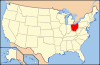
 Location of Pickaway County in Ohio
This is a list of the National Register of Historic Places listings in Pickaway County, Ohio.
This is intended to be a complete list of the properties and districts on the National Register of Historic Places in Pickaway County, Ohio, United States. The locations of National Register properties and districts for which the latitude and longitude coordinates are included below, may be seen in a Google map.[1]
There are 28 properties and districts listed on the National Register in the county.
-
- This National Park Service list is complete through NPS recent listings posted November 10, 2011.[2]
Current listings
[3] Landmark name [4] Image Date listed Location City or town Summary 1 William Marshall Anderson House 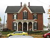
November 29, 1979 131 W. Union St.
39°35′57″N 82°56′50″W / 39.599167°N 82.947222°WCircleville 2 Arledge Mounds I and II July 30, 1974 Address Restricted Pickaway Township Not along any road[5] 3 Ashville Depot February 25, 1980 Madison and Cromley Sts.
39°42′54″N 82°57′20″W / 39.715°N 82.955556°WAshville 4 Bazore Mill December 19, 1978 South of Williamsport on State Route 138 at Deer Creek
39°33′04″N 83°06′31″W / 39.551111°N 83.108611°WDeer Creek Township 5 Bellevue 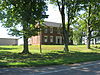
March 17, 1976 North of Kingston on State Route 159
39°29′01″N 82°54′07″W / 39.483611°N 82.901944°WPickaway Township 6 Joseph Black Farmhouse August 9, 1982 9862 Heffner Rd.
39°30′51″N 82°50′47″W / 39.514047°N 82.846325°WPickaway Township 7 Circleville Historic District 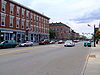
May 16, 1978 Main and Court Sts.
39°36′07″N 82°56′42″W / 39.601903°N 82.945097°WCircleville 8 W.C. Clemmons Mound May 2, 1974 Address Restricted Jackson Township Near Fox 9 Fridley-Oman Farm December 6, 1975 West of Marcy in Slate Run Metropolitan Park
39°45′13″N 82°50′54″W / 39.753611°N 82.848333°WMadison Township 10 Gill-Morris Farm 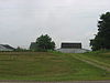
August 14, 1986 10104 State Route 56, southeast of Circleville
39°32′19″N 82°50′36″W / 39.538611°N 82.843333°WSalt Creek Township 11 Horn Mound August 7, 1974 Address Restricted Salt Creek Township Near Tarlton 12 Horsey-Barthelmas Farm July 24, 1980 West of Circleville on State Route 104
39°33′18″N 83°00′32″W / 39.555°N 83.008889°WWayne Township 13 Lawndale Farm Complex April 19, 1984 26476 Gay Dreisbach Rd., south of Circleville
39°32′49″N 82°55′10″W / 39.546944°N 82.919444°WPickaway Township 14 Luthor List Mound 
October 16, 1974 Along the Kingston Pike, southeast of Circleville
39°34′31″N 82°55′29″W / 39.57528°N 82.92472°W[6]Circleville Township Also known as the Burning Mound[4] 15 Matthew McCrea House 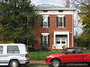
September 29, 1988 428 E. Main St.
39°35′58″N 82°56′12″W / 39.599444°N 82.936597°WCircleville 16 Memorial Hall 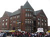
November 21, 1980 165 E. Main St.
39°36′03″N 82°56′34″W / 39.600944°N 82.942761°WCircleville 17 Morris House 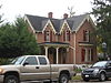
August 3, 1979 149 W. Union St.
39°35′58″N 82°56′56″W / 39.599306°N 82.948942°WCircleville 18 Mount Oval July 25, 1974 Off U.S. Route 23, south of Circleville
39°31′42″N 82°57′59″W / 39.528333°N 82.966389°WPickaway Township 19 Perrill-Goodman Farm House March 14, 1985 Goodman Rd., south of Groveport
39°47′18″N 82°52′56″W / 39.788333°N 82.882222°WMadison Township 20 Stevenson Peters House February 9, 1984 9860 State Route 188, northeast of Circleville
39°40′29″N 82°50′17″W / 39.674722°N 82.838056°WWalnut Township 21 Redlands May 14, 1982 1960 N. Court St., north of Circleville
39°38′06″N 82°56′31″W / 39.635°N 82.941944°WCircleville Township 22 Renick Farm 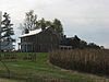
March 5, 1982 North of South Bloomfield on U.S. Route 23
39°45′01″N 82°59′28″W / 39.750278°N 82.991111°WHarrison Township 23 Saint Philip's Episcopal Church 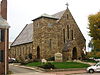
May 15, 1986 129 W. Mound St.
39°35′59″N 82°56′50″W / 39.599722°N 82.947222°WCircleville 24 Scioto Township District No. 2 Schoolhouse May 6, 1987 8143 Snyder Rd., east of Orient
39°47′45″N 83°05′38″W / 39.795833°N 83.093889°WScioto Township 25 The Shack 
May 23, 1974 Northwest of Williamsport
39°38′07″N 83°13′47″W / 39.635278°N 83.229722°WMonroe Township 26 Tick Ridge Mound District June 11, 1975 On Tick Ridge in Deer Creek State Park
39°37′55″N 83°15′5″W / 39.63194°N 83.25139°W[7]Monroe Township 27 Ansel T. Walling House 
December 14, 1987 146 W. Union St.
39°35′58″N 82°56′55″W / 39.599444°N 82.948611°WCircleville 28 Watt-Groce-Fickhardt House 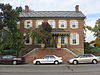
August 23, 1985 360 E. Main St.
39°36′00″N 82°56′20″W / 39.6°N 82.938889°WCircleville See also
References
- ^ The latitude and longitude information provided in this table was derived originally from the National Register Information System, which has been found to be fairly accurate for about 99% of listings. For about 1% of NRIS original coordinates, experience has shown that one or both coordinates are typos or otherwise extremely far off; some corrections may have been made. A more subtle problem causes many locations to be off by up to 150 yards, depending on location in the country: most NRIS coordinates were derived from tracing out latitude and longitudes off of USGS topographical quadrant maps created under the North American Datum of 1927, which differs from the current, highly accurate WGS84 GPS system used by Google maps. Chicago is about right, but NRIS longitudes in Washington are higher by about 4.5 seconds, and are lower by about 2.0 seconds in Maine. Latitudes differ by about 1.0 second in Florida. Some locations in this table may have been corrected to current GPS standards.
- ^ "National Register of Historic Places: Weekly List Actions". National Park Service, United States Department of the Interior. Retrieved on November 10, 2011.
- ^ Numbers represent an ordering by significant words. Various colorings, defined here, differentiate National Historic Landmark sites and National Register of Historic Places Districts from other NRHP buildings, structures, sites or objects.
- ^ a b "National Register Information System". National Register of Historic Places. National Park Service. . http://nrhp.focus.nps.gov/natreg/docs/All_Data.html.
- ^ Meeting minutes for Monday, 18 December 2006, Pickaway County Commissioners, 2006. Accessed 2009-10-14.
- ^ Location derived from its GNIS feature record; the NRIS lists the site as "Address Restricted"
- ^ Location derived from this ODNR webpage; coordinates derived from the GNIS feature record for Tick Ridge. The NRIS lists the site as "Address Restricted".
National Register of Historic Places in Ohio Lists by county Adams • Allen • Ashland • Ashtabula • Athens • Auglaize • Belmont • Brown • Butler • Carroll • Champaign • Clark • Clermont • Clinton • Columbiana • Coshocton • Crawford • Cuyahoga • Darke • Defiance • Delaware • Erie • Fairfield • Fayette • Franklin • Fulton • Gallia • Geauga • Greene • Guernsey • Hamilton • Hancock • Hardin • Harrison • Henry • Highland • Hocking • Holmes • Huron • Jackson • Jefferson • Knox • Lake • Lawrence • Licking • Logan • Lorain • Lucas • Madison • Mahoning • Marion • Medina • Meigs • Mercer • Miami • Monroe • Montgomery • Morgan • Morrow • Muskingum • Noble • Ottawa • Paulding • Perry • Pickaway • Pike • Portage • Preble • Putnam • Richland • Ross • Sandusky • Scioto • Seneca • Shelby • Stark • Summit • Trumbull • Tuscarawas • Union • Van Wert • Vinton • Warren • Washington • Wayne • Williams • Wood • Wyandot
Lists by city Other lists Municipalities and communities of Pickaway County, Ohio City 
Villages Ashville | Commercial Point | Darbyville | Harrisburg‡ | New Holland‡ | Orient | South Bloomfield | Tarlton‡ | Williamsport
Townships Circleville | Darby | Deer Creek | Harrison | Jackson | Madison | Monroe | Muhlenberg | Perry | Pickaway | Salt Creek | Scioto | Walnut | Washington | Wayne
CDP Unincorporated
communitiesFootnotes ‡This populated place also has portions in an adjacent county or counties
Categories:- National Register of Historic Places in Ohio by county
- Pickaway County, Ohio
-


Wikimedia Foundation. 2010.