- Saline County, Missouri
-
Saline County, Missouri 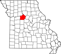
Location in the state of Missouri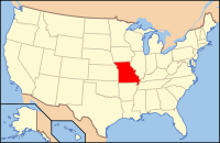
Missouri's location in the U.S.Founded 1820 Named for The salt springs in the region Seat Marshall Largest city Marshall Area
- Total
- Land
- Water
764.59 sq mi (1,980 km²)
755.55 sq mi (1,957 km²)
9.04 sq mi (23 km²), 1.18%Population
- (2000)
- Density
23,756
31/sq mi (12/km²)Time zone Central: UTC-6/-5  Saline County Courthouse
Saline County is a county located in the U.S. state of Missouri. In 2000, the population was 23,756. Its county seat is Marshall[1]. The county was established in 1820 and named for the region's salt springs.
Contents
History
Saline County was formed in 1820. It was named for the salt mines which are found in the region. Saline County was one of the historical settlement areas of the Missouri Indians before relocation on reservations.
Saline County was settled primarily by migrants from the Upper South states of Kentucky, Tennessee and Virginia. They quickly started cultivating crops similar to those in Middle Tennessee and Kentucky: hemp and tobacco. The counties settled by southerners were known as "Little Dixie." By the time of the Civil War, one-third of the county population was African American, most of whom were enslaved laborers on major plantations, particularly for labor-intensive tobacco cultivation.
Geography
According to the 2000 census, the county has a total area of 764.59 square miles (1,980.3 km2), of which 755.55 square miles (1,956.9 km2) (or 98.82%) is land and 9.04 square miles (23.4 km2) (or 1.18%) is water.[2]
Adjacent counties
- Carroll County (northwest)
- Chariton County (northeast)
- Howard County (east)
- Cooper County (southeast)
- Pettis County (south)
- Lafayette County (west)
Major highways
National protected area
- Big Muddy National Fish and Wildlife Refuge (part)
Demographics
At the 2000 census[3], there were 23,756 people, 9,015 households and 6,013 families residing in the county. The population density was 31 per square mile (12/km²). There were 10,019 housing units at an average density of 13 per square mile (5/km²). The racial makeup of the county was 90.03% White, 5.39% Black or African American, 0.31% Native American, 0.35% Asian, 0.21% Pacific Islander, 2.09% from other races, and 1.62% from two or more races. 4.42% of the population were Hispanic or Latino of any race. 28.7% were of German, 18.2% American, 9.8% English and 9.3% Irish ancestry according to Census 2000.
There were 9,015 households of which 30.60% had children under the age of 18 living with them, 51.90% were married couples living together, 10.30% had a female householder with no husband present, and 33.30% were non-families. 28.20% of all households were made up of individuals and 14.60% had someone living alone who was 65 years of age or older. The average household size was 2.45 and the average family size was 2.97.
In Age distribution was 24.30% under the age of 18, 12.00% from 18 to 24, 25.20% from 25 to 44, 22.30% from 45 to 64, and 16.30% who were 65 years of age or older. The median age was 37 years. For every 100 females there were 96.10 males. For every 100 females age 18 and over, there were 93.70 males.
The median household income was $32,743, and the median family income was $39,234. Males had a median income of $27,180 versus $19,431 for females. The per capita income for the county was $16,132. About 10.50% of families and 13.20% of the population were below the poverty line, including 18.90% of those under age 18 and 8.60% of those age 65 or over.
Cities and towns
See also
- National Register of Historic Places listings in Saline County, Missouri
References
- ^ "Find a County". National Association of Counties. http://www.naco.org/Counties/Pages/FindACounty.aspx. Retrieved 2011-06-07.
- ^ "Census 2000 U.S. Gazetteer Files: Counties". United States Census. http://www.census.gov/tiger/tms/gazetteer/county2k.txt. Retrieved 2011-02-13.
- ^ "American FactFinder". United States Census Bureau. http://factfinder.census.gov. Retrieved 2008-01-31.
External links
- Digitized 1930 Plat Book of Saline County from University of Missouri Division of Special Collections, Archives, and Rare Books

Carroll County Chariton County Lafayette County 
Howard County  Saline County, Missouri

Pettis County Cooper County Municipalities and communities of Saline County, Missouri Cities 
Villages Townships Arrow Rock | Blackwater | Cambridge | Clay | Elmwood | Grand Pass | Liberty | Marshall | Miami | Salt Fork | Salt Pond
Unincorporated
communitiesFootnotes ‡This populated place also has portions in an adjacent county or counties
Categories:- Missouri counties
- Saline County, Missouri
- Little Dixie (Missouri)
- Missouri counties on the Missouri River


Wikimedia Foundation. 2010.