- Merthyr Tydfil
-
For the town in Australia, see Merthyr, Queensland.
Merthyr Tydfil County Borough
Bwrdeisdref Sirol Merthyr Tudful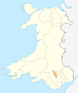
Geography Area
- Total
- WaterRanked 21st
111 km²
17%Admin HQ Merthyr Tydfil ISO 3166-2 GB-MTY ONS code 00PH Demographics Population:
- Total (2010 est.)
- Density
Ranked 22nd
55,700
Ranked 9th
502 / km²Ethnicity 99.6% White. Welsh language
- Any skillsRanked 15th
17.7%Politics 
Merthyr Tydfil County Borough Council
Merthyr.gov.ukControl MP AM Merthyr Tydfil (Welsh: Merthyr Tudful; English pronunciation: /ˈmɜrθər ˈtɪdvɪl/[1]) is a town in Wales, with a population of about 30,000. Although once the largest town in Wales, it is now ranked as the 15th largest urban area in Wales. It also gives its name to a county borough, which has a population of around 55,000. It is located in the historic county of Glamorgan. It is often referred to simply as 'Merthyr'. The current administrative area of the Merthyr County Borough consists of the northern part of the Taff Valley and the smaller neighbouring Taff Bargoed Valley.
According to legend, the town is named after Saint Tydfil, a daughter of King Brychan of Brycheiniog. According to her legend she was slain at Merthyr by pagans around 480; the place was subsequently named Merthyr Tydfil in her honour.[2] Although the usual meaning of the word merthyr (from the Latin martyrium) in modern Welsh is 'martyr', it is probable that the meaning here is "church (in memory of a saint or on his/her grave)." Similar examples, all from south Wales, include Merthyr Cynog, Merthyr Dyfan and Merthyr Mawr. The Cornish and Breton language equivalents, in place names, are merther and merzher.[3]
Contents
History
Pre-history
Various peoples, migrating north from Europe, had lived in the area for many thousands of years. The archaeological record starts from about 1000BCE by the 'Celts' (although the 'Celtic Movement' may be seen as a gradual spreading of ideas rather than an invasion of a particular people) Celt. From their language, the Welsh language may have developed. Hillforts were built during the Iron Age and the tribe that inhabited them in the South Wales area were called the Silures, according to Tacitus, the Roman historian of the Roman invaders.
The Roman invasion
The Romans had arrived in Roman Wales by about 47-53CE and established a network of Roman forts, with Roman roads to link them. They had to fight hard to consolidate their conquests, and in 74 CE they built a Roman auxiliary fortress at Penydarren, overlooking the River Taff (Taf). It covered an area of about 3 hectares, and formed part of the network of roads and fortifications. Remains this fortress were found underneath the football ground where Merthyr Tydfil FC play. A road ran north–south through the area, linking the southern coast with Mid Wales and Watling Street via Brecon. Parts of this and other roads, including one known as Sarn Helen, can still be traced and walked on.
The local tribe, known as the Silures, resisted this invasion fiercely from their mountain strongholds, but the Roman armies eventually prevailed. In time, relative peace was established and the Penydarren fortress was abandoned by about 120 CE. This had an unfortunate effect upon the local economy which had by this time come to rely upon supplying the fortress with beef and grain, as well as imported items such as oysters from the coast. Additionally, intermarriage with local women had occurred and many auxiliary veterans had settled locally on farms.
The Decline of the Roman Empire eventually developed with the Roman legions being withdrawn around 380CE. By 402 CE, the army in Britain comprised mostly Germanic troops and local recruits, and the cream of the army had been withdrawn across to the continent of Europe. Sometime during this period, Irish Dalriadan (Scots) and Picts attacked and breached Hadrians Wall. During the 4th and 5th Centuries the coasts of Cambria (Wales) had been subject to the raids of Irish pirates, in much the same way as the south and East coast of Britain had been raided by Saxon pirates from across the North Sea. Around the middle of the 5th century, Irish settlements had been established around Swansea and the Gower Peninsula as well as in Pembrokeshire and eventually petty kingdoms were establish as far inland as in Brecon. Later, by about 490CE, hordes of Saxons invaded and settled in the east or in "lowland" Britain and the locals were left to their own devices to fight off these new invaders.
The coming of Christianity
The Latin language and some Roman customs and culture became established before the withdrawal of the Roman army. The Christian religion was introduced throughout much of Wales by the Romans, but locally, it may have been introduced later by monks from Ireland and France who made their way into the region following rivers and valleys.
Local legends
Local tradition holds that a girl called Tydfil, daughter of a local chieftain named Brychan, was an early local convert to Christianity, and was pursued and murdered by a band of marauding Picts and Saxons while traveling to Hafod Tanglwys in Aberfan, a local farm that is still occupied to this day. The girl was considered a martyr after her death in approximately 480CE. “Merthyr” translates to “Martyr” in English, and tradition holds that, when the town was founded, the name was chosen in her honour. A church was eventually built on the traditional site of her burial. Images of that church can be found on the Merthyr History website.
The Normans arrive
The valley through which the River Taff flowed was heavily wooded, with a few scattered farms on the mountain slopes, and this situation persisted for several hundred years. The Norman Barons moved in, after the Norman Conquest of England, but by 1093, they only occupied the lowlands and the uplands remained in the hands of the local Welsh rulers. The effect on the locals was probably minimal. There were conflicts between the Barons and the families descended from the Welsh princes, and control of the land passed to and fro in the Welsh Marches. During this time Morlais Castle was built.
Early modern Merthyr
No permanent settlement was formed until well into the Middle Ages. People continued to be self-sufficient, living by farming and later by trading. Merthyr Tydfil was little more than a village. An ironworks existed in the parish in the Elizabethan period, but it did not survive beyond the early 1640s at the latest. In 1754, it was recorded that the valley was almost entirely populated by shepherds. Farm produce was traded at a number of markets and fairs, notably the Waun Fair above Dowlais.[4]
The Industrial Revolution
Influence and growth of iron industry
Merthyr was situated close to reserves of iron ore, coal, limestone and water, making it an ideal site for ironworks. Small-scale iron working and coal mining had been carried out at some places in South Wales since the Tudor period, but in the wake of the Industrial revolution the demand for iron led to the rapid expansion of Merthyr's iron operations. The Dowlais Ironworks was founded by what would become the Dowlais Iron Company in 1759, making it the first major works in the area. It was followed in 1765 by the Cyfarthfa Ironworks. The Plymouth ironworks were initially in the same ownership as Cyfarthfa, but passed after the death of Anthony Bacon to Richard Hill in 1788. The fourth ironworks was Penydarren built by Francis Homfray and Samuel Homfray after 1784.
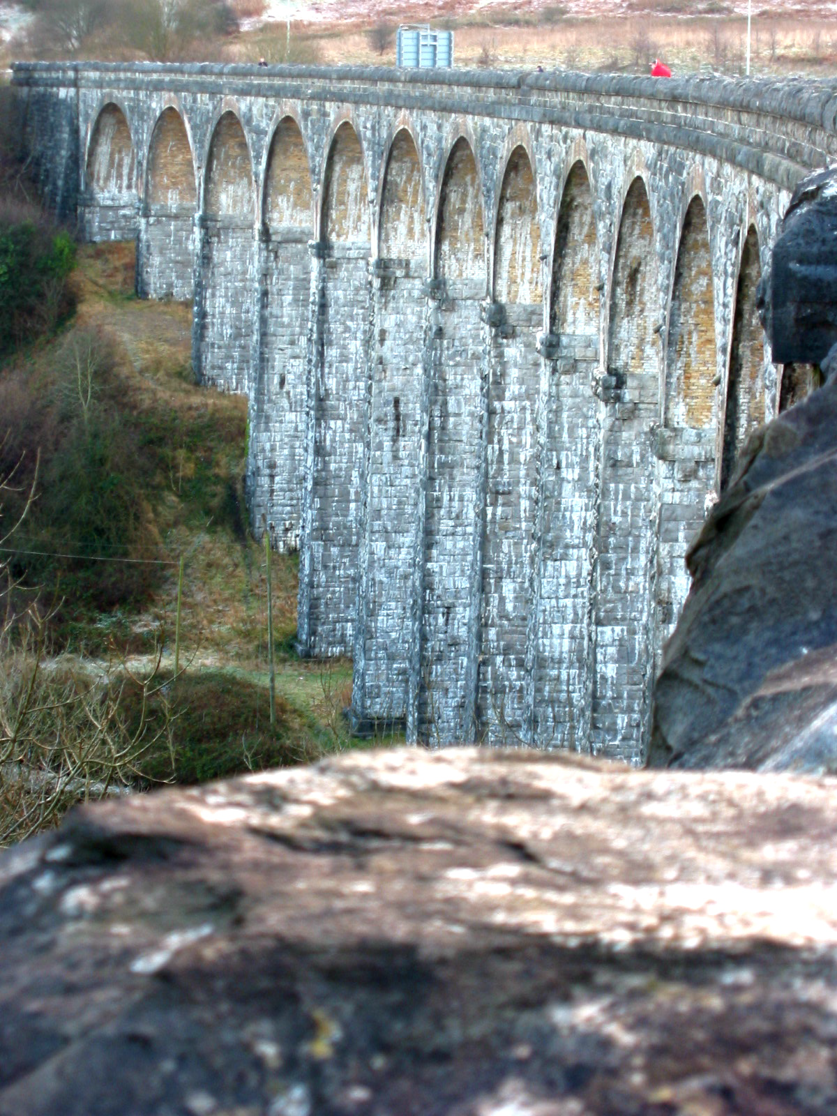
 The Cefn Coed Viaduct was built to carry the Brecon and Merthyr Railway
The demand for iron was fuelled by the Royal Navy, who needed cannon for their ships, and later by the railways. In 1802, Admiral Lord Nelson visited Merthyr to witness cannon being made.
Several railway companies established routes that linked Merthyr with coastal ports or other parts of Britain. They included the Brecon and Merthyr Railway, Vale of Neath Railway, Taff Vale Railway and Great Western Railway. They often shared routes to enable access to coal mines and ironworks through rugged country, which presented great engineering challenges. In 1804, the world’s first railway steam locomotive, "The Iron Horse", developed by the Cornish engineer Richard Trevithick, pulled 10 tons of iron on the newly constructed Merthyr Tramway from Penydarren to Abercynon.[5][6] A replica of this now resides in the National Waterfront Museum in Swansea. The tramway passed through what is arguably the oldest railway tunnel in the world, part of which can still be seen alongside Pentrebach Road at the lower end of the town.
The 1801 census recorded the population of Merthyr as 7705, the most populous parish in Wales (however, the built-up area of Swansea, covering several parishes, then exceeded 10,000). By 1851 Merthyr had overtaken Swansea to become the largest town in Wales with 46,378 inhabitants. By this time, Irish immigrants made up 10% of the local population, and there were substantial numbers of English, together with some Spaniards and Italians.[4] A Jewish community was established some time after 1841, and by 1851, they were able to establish a small prayer hall. The charming Merthyr Synagogue was consecrated in 1875 and a cemetery at Cefn-Coed was established in the 1860s.
During the first few decades of the 19th century, the ironworks at Dowlais and Cyfarthfa continued to expand and at their peak were the most productive ironworks in the world. 50,000 tons of rails left just one ironworks in 1844, to enable expansion of railways across Russia to Siberia. At its peak, the Dowlais Iron Company operated 18 blast furnaces and employed 7,300 people, and by 1857 had constructed the world's most powerful rolling mill. The companies were mainly owned by two dynasties, the Guest and Crawshay families. One of the famous members of the Guest family was Lady Charlotte Guest who translated the Mabinogion into English from its original Welsh. The families also supported the establishment of schools for their workers.
Thomas Carlyle visited Merthyr in 1850, writing that the town was filled with such "unguided, hard-worked, fierce, and miserable-looking sons of Adam I never saw before. Ah me ! It is like a vision of Hell, and will never leave me, that of these poor creatures broiling, all in sweat and dirt, amid their furnaces, pits, and rolling mills."[7]
The Merthyr Rising

The Merthyr Rising of 1831 were precipitated by a combination of the ruthless collection of debts, frequent wage reductions when the value of iron periodically fell, and the imposition of truck shops. Instead of using normal coin of the realm, some Ironmasters paid their workers in specially minted coins or credit notes, known as "truck". These could only be exchanged at shops owned by the same ironmasters. Many of the workers objected to both the price and quality of the goods sold in these company-owned shops.
There is still controversy over what actually happened and who was to blame. It was probably more of an armed rebellion than an isolated riot. The initiators of the unrest were most probably the skilled workers; men who were much prized by the owners and often on friendly social terms with them. They also valued their loyalty to the owners and looked aghast at the idea of forming trade unions to demand higher wages. But events overtook them, and the community was tipped into rebellion.
The owners took fright at the challenge to their authority, and called on the military for assistance. Soldiers were sent from the garrison at Brecon. They clashed with the rioters, and several on both sides were killed. Despite the hope that they could negotiate with the owners, the skilled workers lost control of the movement.
Some 7,000 to 10,000 workers marched under a red flag, which was later adopted internationally as the symbol of the working classes. For four days, magistrates and ironmasters were under siege in the Castle Hotel, and the protesters effectively controlled Merthyr.[4]
Even with their numbers and captured weapons, they were unable to effectively oppose disciplined soldiers for very long, and several of the supposed leaders of the riots were arrested. Some were transported as convicts to the penal colonies of Australia. One of them, Richard Lewis, popularly known as Dic Penderyn, was hanged for the crime of stabbing a soldier named Donald Black in the leg. Lewis became known as the first local working-class martyr.
Alexander Cordell's low-brow novel The Fire People is set in this period. A more serious political history of these events, The Merthyr Rising was written by the Merthyr-born Marxist writer Professor Gwyn A. Williams in 1978.
The first trade unions, which were illegal and suppressed, formed shortly after the riots. The rising also helped create the momentum that led to the Reform Act. The Chartism movement, which did not consider these reforms extensive enough, was subsequently active in Merthyr.
Many families had had enough of the strife, and they left Wales to use their skills elsewhere. Numerous people set out by ship to America, where the steelworks of Pittsburgh were booming. It only cost about five pounds to travel steerage.[citation needed]
The decline of coal and iron
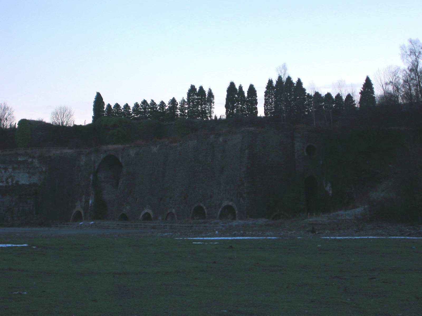
 The abandoned Cyfarthfa Ironworks blast furnaces
The population of Merthyr reached 51,949 in 1861, but went into decline for several years thereafter. As the 19th century progressed, Merthyr's inland location became increasingly disadvantageous for iron production, and only the Dowlais works invested in steelmaking technology. Penydarren closed in 1859 and Plymouth in 1880; thereafter some ironworkers migrated to the United States or even Ukraine, where Merthyr engineer John Hughes established an ironworks in 1869.[4]
In the 1870s the advent of coal mining to the south of the town gave renewed impetus to the local economy and population growth. New mining communities developed at Merthyr Vale, Treharris and Bedlinog, and the population of Merthyr itself rose to a peak of 80,990 in 1911. The growth of the town led to its grant of county borough status in 1908.[4]
The steel and coal industries began to decline after World War I, and by the 1930s, they had all closed. By 1932, more than 80% of men in Dowlais were unemployed; Merthyr experienced an out-migration of 27,000 people in the 1920s and 1930s, and a Royal Commission recommended that the town's county borough status should be abolished.[4] The fortunes of Merthyr revived temporarily during World War II, as war-related industry was established in the area. In the post-war years the local economy became increasingly reliant on light manufacturing, often providing employment for women rather than men.
In 1987, the iron foundry, all that remained of the former Dowlais ironworks, finally closed, marking the end of 228 years continuous production on one site.
Post-Second World War
Immediately following the Second World War, several large companies set up in Merthyr. In October 1948, the American-owned Hoover Company opened a large washing machine factory and depot in the village of Pentrebach, a few miles south of Merthyr Tydfil. The factory was purpose-built to manufacture the Hoover Electric Washing Machine, and at one point, Hoover was the largest employer in the borough. At the Hoover factory the Sinclair C5 was built.
Several other companies built factories, including an aviation components company, Teddington Aircraft Controls, which opened in 1946. The Teddington factory closed in the early 1970s. The local Merthyr Tydfil Institute for the Blind, founded in 1923, remains the oldest active manufacturer in the town.[8]
The Gurnos housing estate was, at the time of its construction, the largest council housing project in the world.[citation needed]
Cyfarthfa, the former home of the ironmaster Richard Crawshay, an opulent mock-castle, is now a museum. It houses a number of paintings of the town, a large collection of artefacts from the town's Industrial Revolution period, and a notable collection of Egyptian tomb artefacts, including several sarcophagi.
In 1966 a colliery tip slid down a mountain covering a school causing the Aberfan disaster.
While testing a new angina treatment, researchers in Merthyr Tydfil discovered (purely by accident) that the new drug had erection-stimulating side effects. This discovery would go on to form the basis for Viagra.[9] The inventor Howard Stapleton, based in Merthyr Tydfil, developed the technology that has given rise to the recent mosquitotone or Teen Buzz phenomenon.[10]
Government
The current borough boundaries date back to 1974, when the former county borough of Merthyr Tydfil expanded slightly to cover Vaynor in Breconshire and Bedlinog in Glamorgan. Merthyr Tydfil became a local government district in the administrative county of Mid Glamorgan at that time, although it reverted back to a county borough again on 1 April 1996.
Merthyr Tydfil County Borough Council is the governing body for the area. It consists of 33 councillors representing 11 wards. During the local government elections of 1 May 2008, the long-ruling Welsh Labour Party lost its majority control of Merthyr council as a cohort of independents took seats and the Liberal Democrats also made a significant breakthrough. The present composition of the council stands at Independents 13; Labour 10; Liberal Democrats 4; Merthyr Independents 3; 2 UKIP (elected as Independents) and 1 other.
Despite being widely regarded as one of its traditional heartlands, support for the Welsh Labour Party has waned significantly in recent years; as indeed the recent local election results confirm. In the 2005 General Election there was a 3.9% swing from Labour to the Liberal Democrats and in the 2007 Welsh Assembly Election there was a massive 15.8% swing from Labour to the Liberal Democrats. This was followed in the 2010 General Election by a further 16.9% swing from Labour to the Liberal Democrats, the 3rd largest such swing in the United Kingdom. Labour's marority in the seat now stands at 4,000 votes.
The current Member of Parliament for the Merthyr Tydfil and Rhymney constituency is Dai Havard, while the Welsh Assembly member is Huw Lewis AM.
Additionally, the Bedlinog Ward in the Merthyr Tydfil County Borough, which covers the villages of Trelewis and Bedlinog in the neighbouring Taff Bargoed Valley, is governed by a separate local authority, Bedlinog Community Council, which consists of nine elected members, and whose powers and responsibilities cover the two villages within its area. The Ward is the only electoral area within the Merthyr Tydfil County Borough Council area with its own Council. The Council was created in 1974 by the former Gelligaer Urban District Council prior to its abolition and the subsequent transfer of Trelewis and Bedlinog into the Merthyr administrative area upon local government reorganisation in that year, to which most people in Bedlinog and Trelewis were opposed.
Industrial legacy
Merthyr Tydfil has a long and varied industrial heritage, and was one of the seats of the industrial revolution (see history below). Since the end of the Second World War, much of this has declined, with the closure of long-established coal mining collieries, and both steel and ironworks. Despite recent improvements, some parts of the town remain economically disadvantaged, and there is a significant proportion of the community who are long-term unemployed.
In Britain today, Merthyr:
- Ranks 13th worst for economic activity
- Ranks 13th worst for life expectancy: women live on average 79.1 years, and men 75.5. This is lower than the average for England but better than the Scottish and north of England averages[11]
- Has 30% of the population suffering from a limiting long-term illness.
A[12][13] Channel 4 programme rated Merthyr Tydfil as the third worst place to live in Britain in 2006 following areas of London.[14]
However, in the 2007 edition of the same programme, Merthyr had `improved` to fifth worst place to live.[15]Culture
Merthyr is home to several established choirs who perform regularly in the local area and throughout the rest of the world. They include Ynysowen Male Choir, Treharris Male Voice Choir, Dowlais Male Voice Choir, Merthyr Tydfil Ladies Choir, Cantorion Cyfartha, and the mixed-voice choir Con Voce.
The town has held many cultural events. Local poets and writers hold poetry evenings in the town, and music festivals are organised at Cyfarthfa Castle and Park. With this in mind, Merthyr's Welsh Language and Initiative Centre are working on a new project to transform the Zoar Chapel and the adjacent vestry building in Pontmorlais into a community arts venue. Also recently opened was Merthyr Tydfil College's Theatr Myfanwy Theatre, where students perform dance, musicals, plays, and instrumental and vocal concerts, and where students work with some of the best in the business, including members of the Welsh National Opera.
Merthyr has several historical and heritage groups:
The Merthyr Tydfil Heritage Regeneration Trust, which has as its aim - "To preserve for the benefit of the residents of Merthyr Tydfil and of the Nation at large whatever of the Historical, Architectural and Constructional Heritage may exist in and around Merthyr Tydfil in the form of buildings and artefacts of particular beauty or of Historical, Architectural or Constructional interest and also to improve, conserve and protect the environment thereto."[16]
The Merthyr Tydfil Historical Society, which has as its aim - "To advance the education of the public by promoting the study of the local history and architecture of Merthyr Tydfil".[17]
The Merthyr Tydfil Museum and Heritage Groups, which has as its aim - "To advance the education of the public by the promotion, support and improvement of the Heritage of Merthyr Tydfil and its Museums."[18]
Merthyr Tydfil's Central Library, which is in a prominent position in the centre of the town, is a Carnegie library.
Merthyr Tydfil hosted the National Eisteddfod in 1881 and 1901 and the national Urdd Gobaith Cymru Eisteddfod in 1987.
Tourism
The town is located in a South Wales Valleys environment just south of the Brecon Beacons National Park, and this, along with the town's rich history, means it has huge potential for tourism in Wales. National Cycle Route 8 passes through the town. The Brecon Mountain Railway is easily accessible by cycle and car. Merthyr is also on the fringes of Fforest Fawr Geopark designated in 2005 in respect of the area's outstanding geological and cultural heritage. The borough has recently been awarded European Funding as part of the Interreg Collabor8 project and will be working in partnership with the Brecon Beacons National Park Authority to promote the region across Europe.
The Taff Bargoed Valley is increasingly becoming an area for outdoor activities and is home to Parc Taff Bargoed and the Summit Centre (formerly Welsh International Climbing Centre). Settlements of interest include Bedlinog, Quakers Yard, Nelson, Trelewis, and Treharris.
Transport
Roads
Road improvements mean the town is increasingly a commuter location and has shown some of the highest house price growth in the UK.[19][20]
Public transport
Regular rail services operate from Merthyr Tydfil railway station to Cardiff Queen Street and Cardiff Central. Public transport links to Cardiff are being improved.[21]
Employment
Modern-day Merthyr relies on a combination of public sector and manufacturing and service sector companies to provide employment. The Welsh Assembly Government has recently opened a major office in the town[22] near a large telecommunications call centre. Hoover (now part of the Candy Group) has its Registered Office in the town and remained a major employer until it transferred production abroad in March 2009, resulting in the loss of 337 jobs after the closure of its factory.
Sports and leisure
- Cricket
Hills Plymouth Cricket Club is the oldest established Cricket club in the Merthyr area, based to the south of the town. Penydarren Country XI Cricket Club was founded in 1971 and currently play at the ICI Rifle Fields Ground.
- Boxing
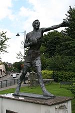
Merthyr is particularly known for its boxers, both amateur and professional. Some famous professional pugilists from the town include: Johnny Owen, Howard Winstone, and Eddie Thomas.
- Football
In sporting terms, Merthyr is widely recognised for its soccer team, Merthyr Tydfil F.C.. 'The Martyrs' currently compete in the British Gas Business Southern Football League Premier Division — three promotions away from the Football League and play home games at the Rhiw Dda’r ground. The club had their proudest moment in 1987, when having won the Welsh Cup and qualified for the European Cup Winners Cup, they beat Italian football team Atalanta 2–1 at Penydarren Park.
The town was once home to a fully professional Football League club, Merthyr Town F.C., which folded in the 1930s and Merthyr Tydfil AFC were founded in 1945. The year of 2008 marked the centenary of football having been played at Penydarren Park (1908 – 2008). After going into liquidation in 2010, the club switched grounds to Rhiw Dda’r.
- Golf
Merthyr Tydfil Golf Club is situated on the southeastern slopes of Cefn Cil Sanws, a rough gritstone and limestone hill northwest of the town. It is one of the highest golf courses in Britain.
- Rugby union
The local rugby union club, Merthyr RFC, is known as 'the Ironmen'. Merthyr RFC was one of the twelve founding clubs of the Welsh Rugby Union in 1881.
- Rugby league
Merthyr Tydfil is home to the Tydfil Wildcats Rugby League team who played at The Cage in Troedyrhiw until September 2010. For 2011 the club is hosted by Dowlais RFC. Merthyr Tydfil was one of the first rugby league sides formed in Wales in 1907 and notably beat the first touring Australian side in 1908.
Education
- Colleges
- Vocational training providers
- Tydfil Training Consortium Limited
- Secondary schools
- Primary schools/nurseries
- Abercanaid Junior School
- Brecon Road Infants School[23]
- Caedraw Primary School[24]
- Edwardsville Primary School[25]
- Goetre Primary School
- St. Aloysius R.C. Primary School
- Troedyrhiw Junior School
- Ysgol Rhyd y Grug — primary school; teaches through the medium of Welsh
- Ysgol Santes Tudful[26] — primary school; teaches through the medium of Welsh
- Ysgol Y Graig Primary[27]
- Twynyrodyn Community School
- Pantysgallog Primary School
- Heolgerrig Primary School
Mining
In 2006, a large open cast coal mine, which will extract 10 million tonnes of coal over 15 years, was authorised just east of Merthyr Tydfil as part of the Ffos-y-fran Opencast mine.
Notable people
- See Category:People from Merthyr Tydfil
Among those born in Merthyr Tydfil are:
- Neil Peters — International Pool Player
- Gareth Abraham — professional footballer
- Barrie Bates — professional darts player
- Laura Ashley — fashion designer and retailer
- William Berry, 1st Viscount Camrose — newspaper proprietor, and his brothers Seymour Berry (Baron Buckland) and James Gomer Berry, 1st Viscount Kemsley
- Richard Davies — actor
- Kevin Gall — professional footballer
- Sir Samuel Griffith — Australian politician
- Craig Handley — film director
- John Hughes — businessman
- Michael 'Micky' Jones (1942 – 10 March 2010) —Guitarist, singer and songwriter with The Bystanders and Man
- William Ifor Jones — American conductor and organist
- Julien Macdonald — fashion designer
- Philip Madoc — actor
- Leslie Norris — poet
- Johnny Owen — boxer
- Joseph Parry — composer
- Mark Pembridge — Wales international football player
- Robert Sidoli — Welsh rugby international
- Sean Smith — singer (The Blackout)
- Rob Spragg — aka Larry Love — frontman (lead vocals) for Alabama 3
- Eddie Thomas — boxer
- Malcolm Vaughan — Singer/Actor
- Howard Winstone — Boxer
- The Blackout — post-hardcore band
- Michael Gustavius Payne — Artist (painter)
- Glyn Jones — Poet
- Mike Jenkins — Poet and author
- Mario Basini — Journalist, broadcaster and author
- Des Barry — Author
- Ian Watkins — Lead singer of Lostprophets
Other notable residents included Esther Isaacs, mother of "Chariots of Fire" athlete Harold Abrahams; the singer-songwriter Katell Keineg, whose mother is a native of Merthyr; the grandfather of Rolf Harris also came from Merthyr. Sam Hughes began his career as a noted player of the ophicleide in the Cyfarthfa Brass Band. One of the first two Labour MPs to be elected to parliament, the Scot Keir Hardie, was elected by the Merthyr Tydfil constituency.The 1970s juvenile group The Osmonds are of Welsh descent and have traced their ancestry to Merthyr.[28] Also associated with the town are poet, journalist and Welsh Nationalist Harri Webb, and poet, author and journalist Grahame Davies.
References in art and literature
- In the third episode of the 1978 BBC sitcom Going Straight Merthyr Tydfil is referred to as having, ".. more pubs.. than anywhere else in Britain, and they're all shut Sundays."
- In author Jasper Fforde's Thursday Next series (set in an alternate history), begun in 2001, Merthyr Tydfil is the capital of an independent People's Republic of Wales.
- Australian poet Les Murray references his experiences in the town in his poem, "Vindaloo in Merthyr Tydfil".
- Canadian songwriter Jane Siberry uses "the slags of Merthyr Tydfil" as an image in her song "You Don't Need", from the 1984 album No Borders Here.
- The 1998 flim The Theory of Flight, directed by Paul Greengrass, and staring Kenneth Branagh and Helena Bonham Carter was filmed in Merthyr Tydfil.
See also
- List of places in Merthyr Tydfil - a list of settlements
- Pont-y-Cafnau - the world's earliest surviving iron railway bridge
Notes
- ^ Wells, John (12 January 2010). "Merthyr". John Wells's phonetic blog. http://phonetic-blog.blogspot.com/2010/01/merthyr.html. Retrieved 5 March 2010.
- ^ Farmer, David Hugh. (1978). "Tydfil". In The Oxford Dictionary of Saints.
- ^ University of Wales Dictionary, vol. III, page 2436.
- ^ a b c d e f The Welsh Academy Encyclopedia of Wales. Cardiff: University of Wales Press 2008.
- ^ Pembrokeshire-wales.info
- ^ Trevithick2004.co.uk
- ^ James Anthony Froude, Thomas Carlyle: A History of his Life in London 1834-1881, Longmans, vol 2, 1855, p. 52.
- ^ MTIB.co.uk
- ^ Wired 14.03: START
- ^ "Firm's ringtone 'next Crazy Frog'". BBC News. 14 June 2006. http://news.bbc.co.uk/1/hi/wales/5077026.stm. Retrieved 12 May 2010.
- ^ WebPage
- ^ 'Third worst place in UK' — but Valleys town disputes claims — icWales
- ^ "Ten reasons to love 'worst town'". BBC News. 10 August 2005. http://news.bbc.co.uk/1/hi/wales/4135200.stm. Retrieved 12 May 2010.
- ^ Merthyr Tydfil: Best and Worst Places to Live in the UK 2006 from channel4.com
- ^ Channel4.com
- ^ MTHT.co.uk
- ^ MTHS.co.uk
- ^ MTHT.co.uk
- ^ "Merthyr named UK's house hotspot". BBC News. 16 October 2004. http://news.bbc.co.uk/1/hi/wales/south_east/3749242.stm. Retrieved 12 May 2010.
- ^ "House price boom as market grows". BBC News. 8 August 2006. http://news.bbc.co.uk/1/hi/wales/5253662.stm. Retrieved 12 May 2010.
- ^ "£19m for Merthyr-Cardiff trains". BBC News. 8 February 2007. http://news.bbc.co.uk/1/hi/wales/6342357.stm. Retrieved 12 May 2010.
- ^ "Assembly building in valleys town". BBC News. 30 November 2006. http://news.bbc.co.uk/1/hi/wales/south_east/6157287.stm. Retrieved 12 May 2010.
- ^ Breconroad.merthyr.sch.uk
- ^ Caedraw.merthyr.sch.uk
- ^ Edwardsville.merthyr.sch.uk
- ^ Santestudful.merthyr.sch.uk
- ^ Ysgol-y-graig.merthyr.sch.uk
- ^ BBC — South East Wales Merthyr — Donny Osmond Coming Home
References
- A Brief History of Merthyr Tydfil by Joseph Gross. The Starling Press. 1980
- The Merthyr Rising by Gwyn A Williams. University of Wales Press,
- The Oxford Dictionary of National Biography. Oxford University Press,
- People, Protest and Politics, case studies in C19 Wales By David Egan, Gomer 1987
- Cyfres y Cymoedd: Merthyr a Thaf, edited by Hywel Teifi Edwards. Gomer, 2001
- Civilizing the Urban: Popular culture and Urban Space in Merthyr, c. 1870-1914 by Andy Croll. University of Wales Press. 2000.
- Methyr Tydfil A.F.C. 1945-1954: The Glory Years By Philip Sweet. T.T.C. Books. 2008
- The Eccles, Antiquities of the Cymry; or The Ancient British Church by John Williams (1844), p116.
- Noteworthy Merthyr Tydfil Citizens by Keith L. Lewis-Jones. Merthyr Tydfil Heritage Trust 2008.mtht.co.uk
- Merthyr Historian volumes 1 - 21, Merthyr Tydfil Historical Society. mths.co.uk
External links
- Old Merthyr Tydfil — Historical Photographs of Merthyr Tydfil.
- Merthyr Tydfil County Borough Council
- BBC Merthyr Tydfil life
- Menter a Chanolfan Iaith Merthyr Tudful Welsh Language Initiative and Centre for Merthyr Tydfil
- www.geograph.co.uk : photos of Merthyr Tydfil and surrounding area
- Merthyr Tydfil Historical Society
- Merthyr Tydfil Heritage Regeneration Trust
- Article on Merthyr Tydfill in the Daily Telegraph
- Merthyr Tydfil at the Open Directory Project
Merthyr Tydfil County Borough Communities Bedlinog · Cyfarthfa · Dowlais · Gurnos · Merthyr Vale · Pant · Park · Penydarren · Merthyr Tydfil · Treharris · Troed-y-rhiw · Vaynor
Towns and villages Aberfan · Abercanaid · Bedlinog · Dowlais · Edwardsville · Gellideg · Georgetown · Gurnos · Heolgerrig · Merthyr Vale · Mount Pleasant · Pant · Panteg · Park · Pentrebach · Penydarren · Pontsarn · Pontygwaith · Quakers Yard · Quar · Merthyr Tydfil · Trefechan · Treharris · Trelewis · Troed-y-rhiw · Twynyrodyn · VaynorRivers Principal areas of Wales Anglesey • Blaenau Gwent • Bridgend • Caerphilly • Cardiff • Carmarthenshire • Ceredigion • Conwy • Denbighshire • Flintshire • Gwynedd • Merthyr Tydfil • Monmouthshire • Neath Port Talbot • Newport • Pembrokeshire • Powys • Rhondda Cynon Taf • Swansea • Torfaen • Vale of Glamorgan • Wrexham
Coordinates: 51°45′N 3°23′W / 51.75°N 3.383°W
Clwyd Dyfed Gwent Gwynedd Mid Glamorgan Powys South Glamorgan West Glamorgan Lliw Valley • Neath • Port Talbot • Swansea
Categories:- Merthyr Tydfil
- Principal areas of Wales


Wikimedia Foundation. 2010.