- Hanson, Massachusetts
-
This article is about the town of Hanson. For the census-designated place within the town,, see Hanson (CDP), Massachusetts.
Hanson, Massachusetts — Town — Wampatuck Pond, view from beside the Hanson Town Hall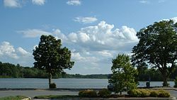

SealLocation in Plymouth County in Massachusetts
Coordinates: 42°04′30″N 70°52′50″W / 42.075°N 70.88056°WCoordinates: 42°04′30″N 70°52′50″W / 42.075°N 70.88056°W Country United States State Massachusetts County Plymouth Settled 1632 Incorporated 1820 Government – Type Open town meeting Area – Total 15.7 sq mi (40.6 km2) – Land 15.0 sq mi (38.9 km2) – Water 0.7 sq mi (1.7 km2) Elevation 90 ft (27 m) Population (2000) – Total 9,495 – Density 632.5/sq mi (244.2/km2) Time zone Eastern (UTC-5) – Summer (DST) Eastern (UTC-4) ZIP code 02341 Area code(s) 339 / 781 FIPS code 25-28495 GNIS feature ID 0619468 Website www.hanson-ma.gov Hanson is a town in Plymouth County, Massachusetts, United States. The population was 9,495 at the 2000 census.
Contents
History
Hanson was first settled in 1632 as the western parish of Pembroke. The town was officially incorporated in 1820, and was named for Maryland newspaper publisher and U.S. Senator Alexander Contee Hanson. The town's early industry revolved around farming, as well as bog iron and quarrying. Mills also popped up along the rivers during the nineteenth century. Today the town is mostly residential, with some farming and cranberry farming. Ocean Spray was first started by several bogs in Hanson.[1]
Geography
According to the United States Census Bureau, the town has a total area of 15.7 square miles (40.6 km²), of which, 15.0 square miles (38.9 km²) of it is land and 0.7 square miles (1.7 km²) of it (4.21%) is water. It is the 250th largest town in the Commonwealth, over seven square miles smaller than the average. Hanson is considered one of the inland towns of Massachusetts's South Shore, and is bordered by Rockland and Hanover to the north, Pembroke to the east, Halifax to the south, East Bridgewater to the west, and Whitman to the northwest. Hanson is located approximately nine miles east of Brockton, thirteen miles (19 km) south of Quincy, and eighteen miles (29 km) south-southeast of Boston.
Several neighborhoods in Hanson have been given names that have stuck over many years. To the south, on the border with the Town of Halifax is the Monponsett neighborhood which actually has its own Post Office and zip code (02350). Monponsett is named for the Monponsett Twin Lakes which lie along much of the Hanson/Halifax border. In South Hanson, the area of Burrage was named for Albert Burrage, one of the Town's most prominent industrialists. He formed the Atlantic Dyestuff Company which had its first factory where present day Hawks Avenue and the Litecontrol Corporation are located. Burrage includes portions of Pleasant Street, South Street and Reed Street. The Brentwood section of Hanson encompasses much of Gorwin Drive and several of its side streets in the central part of Hanson.
Hanson, like many towns in central Plymouth County, is dominated by lakes, rivers and swamps. The largest ponds include Oldham Pond along the Pembroke town line, Indian Head Pond (the source of the Indian Head Brook) just south of Oldham Pond, Maquan Pond, located east of the center of the town, and Wampatuck Pond, located in the center of the town. In addition to Indian Head Brook, the town has several other brooks and rivers, including the Shumatuscacant River and Poor Meadow Brook to the west, and the White Oak Brook to the south. To the north of town lies the Little Cedar Swamp, along the Indian Head Brook. There is a small town forest and two camps, Rainbow Camp and Camp Kiwanee, within the town as well. Burrage Pond Wildlife Management Area lies mainly in the section of town called Burrage or South Hanson. About half of the 1,625 acres (7 km2) are in Hanson, the other half in Halifax.
Demographics
Historical populations Year Pop. ±% 1850 1,217 — 1860 1,245 +2.3% 1870 1,219 −2.1% 1880 1,309 +7.4% 1890 1,267 −3.2% 1900 1,455 +14.8% 1910 1,854 +27.4% 1920 1,910 +3.0% 1930 2,184 +14.3% 1940 2,570 +17.7% 1950 3,264 +27.0% 1960 4,370 +33.9% 1970 7,148 +63.6% 1980 8,617 +20.6% 1990 9,028 +4.8% 2000 9,495 +5.2% 2001* 9,678 +1.9% 2002* 9,788 +1.1% 2003* 9,804 +0.2% 2004* 9,800 −0.0% 2005* 9,804 +0.0% 2006* 9,875 +0.7% 2007* 9,944 +0.7% 2008* 10,046 +1.0% 2009* 10,139 +0.9% 2010 10,209 +0.7% * = population estimate.
Source: United States Census records and Population Estimates Program data.[2][3][4][5][6][7][8][9][10][11]As of the census[12] of 2000, there were 9,495 people, 3,123 households, and 2,545 families residing in the town. The population density was 632.5 people per square mile (244.2/km²). There were 3,178 housing units at an average density of 211.7 per square mile (81.7/km²).
There were 3,123 households out of which 40.3% had children under the age of 18 living with them, 69.6% were married couples living together, 8.7% had a female householder with no husband present, and 18.5% were non-families. 14.8% of all households were made up of individuals and 6.1% had someone living alone who was 65 years of age or older. The average household size was 3.03 and the average family size was 3.38.
In the town the population was spread out with 28.2% under the age of 18, 6.9% from 18 to 24, 31.1% from 25 to 44, 25.1% from 45 to 64, and 8.6% who were 65 years of age or older. The median age was 36 years. For every 100 females there were 97.2 males. For every 100 females age 18 and over, there were 93.7 males.
The median income for a household in the town was $62,687, and the median income for a family was $68,560. Males had a median income of $46,508 versus $31,337 for females. The per capita income for the town was $23,727. About 2.8% of families and 3.8% of the population were below the poverty line, including 2.3% of those under age 18 and 11.6% of those age 65 or over.
Statistically, Hanson is the 180th most populous and the 154th most densely populated town in Massachusetts. It is just below the median in terms of population, and below the average but above the median in terms of density.
Government
 The Hanson Town Hall
On the national level, Hanson is divided between the Ninth and Tenth congressional districts, with precinct two (the northeastern portion of town) being currently represented by Bill Keating, and precincts one and three represented by Stephen Lynch. The state's senior (Class II) member of the United States Senate, re-elected in 2008, is John Kerry. The junior (Class I) senator, elected in 2010, is Scott Brown.
On the state level, Hanson is represented in the Massachusetts House of Representatives as a part of the Sixth Plymouth district, which includes the towns of Duxbury, Pembroke and portions of Halifax. The town is represented in the Massachusetts Senate as a part of the Second Plymouth and Bristol district, which includes Brockton, Halifax, Hanover, Whitman and portions of East Bridgewater and Easton.[13] The town is patrolled by the First (Norwell) Barracks of Troop D of the Massachusetts State Police.[14]
Hanson is governed by the open town meeting form of government, and is led by Town Administrator and a five member Board of Selectmen. The town hall is located on the shore of Wampatuck Pond, at the town center. In the same area are the Fire Department headquarters and the Hanson Public Library, which is a member of the Southeastern Area Internet Library Sharing (SAILS) network. The Hanson Police Department headquarters, built in 2007, is located on Main Street (Rte. 27). There is a branch firehouse along Route 27 near the train station, and the town's post office is located near the intersection of Routes 27 and 58. The town also operates a Memorial Hall, where town meetings and other town functions are held.
Education
Hanson shares the Whitman-Hanson Regional School District with neighboring Whitman. The town of Hanson operates two elementary schools, Indian Head and Maquan, both of which are located on either side of School Street. Maquan serves students from kindergarten through second grade, and Indian Head serves students from third through fifth grades. Hanson Middle School also serves students in grades six through eight. The town sends their students to Whitman-Hanson Regional High School, which is shared with the neighboring town of Whitman. The school was recently rebuilt through part of a $50 million project. It is located behind the previous, (which has been torn down and replaced with new athletic fields including a synthetic turf football field) along Route 27 on the town line. Whitman-Hanson's teams are known as the Panthers, and their colors are red and black. Their chief rival is nearby Abington High, whom they play in the annual Thanksgiving Day football game.
In addition to Whitman-Hanson, students may choose to attend South Shore Vocational Technical High School in Hanover free of charge.
The nearest colleges to Hanson are Massasoit Community College in Brockton, Bridgewater State College in Bridgewater, and Quincy College in Quincy.
Transportation
There are no freeways in Hanson; it is situated equidistantly between Routes 3 and 24. The main state routes through town are Route 14 and Route 58, which intersect and run coextensively for a short stretch in the middle of town. Route 27 also passes through the town, following a portion of the Whitman and East Bridgewater borders before crossing the southern section of town.
The town lies along the Kingston-Plymouth line of the MBTA's commuter rail service, with a stop along Route 27. There is a small airport, Cranland Airport, which serves only small aircraft. The nearest national and international air service is at Logan International Airport in Boston.
Notable residents
- Rear Admiral Albert C. Read (1887–1967) Commander/Navigator of the NC-4, The first aircraft to complete a transatlantic flight in 1919.
- Tiffany Scott, 2002 Olympic Figure Skater.
- Rocky Marciano, The only undefeated heavyweight boxing champion had a house located on Main Street in Hanson.
- Jimmy Slyde (b.James T. Godbolt 1927-2008), World renowned Tap Dancer, famous for his innovative tap style mixed with jazz. Danced in films The Cotton Club, Tap, and Round Midnight. Received Tony Award nomination for his Broadway Debut in the Musical Black & Blue.
References
- ^ USGenWeb - Hanson, MA History
- ^ "TOTAL POPULATION (P1), 2010 Census Summary File 1, All County Subdivisions within Massachusetts". United States Census Bureau. http://factfinder2.census.gov/bkmk/table/1.0/en/DEC/10_SF1/P1/0400000US25.06000. Retrieved September 13, 2011.
- ^ "Massachusetts by Place and County Subdivision - GCT-T1. Population Estimates". United States Census Bureau. http://factfinder.census.gov/servlet/GCTTable?_bm=y&-geo_id=04000US25&-_box_head_nbr=GCT-T1&-ds_name=PEP_2009_EST&-_lang=en&-format=ST-9&-_sse=on. Retrieved July 12, 2011.
- ^ "1990 Census of Population, General Population Characteristics: Massachusetts". US Census Bureau. December 1990. Table 76: General Characteristics of Persons, Households, and Families: 1990. 1990 CP-1-23. http://www.census.gov/prod/cen1990/cp1/cp-1-23.pdf. Retrieved July 12, 2011.
- ^ "1980 Census of the Population, Number of Inhabitants: Massachusetts". US Census Bureau. December 1981. Table 4. Populations of County Subdivisions: 1960 to 1980. PC80-1-A23. http://www2.census.gov/prod2/decennial/documents/1980a_maABC-01.pdf. Retrieved July 12, 2011.
- ^ "1950 Census of Population". Bureau of the Census. 1952. Section 6, Pages 21-10 and 21-11, Massachusetts Table 6. Population of Counties by Minor Civil Divisions: 1930 to 1950. http://www2.census.gov/prod2/decennial/documents/23761117v1ch06.pdf. Retrieved July 12, 2011.
- ^ "1920 Census of Population". Bureau of the Census. Number of Inhabitants, by Counties and Minor Civil Divisions. Pages 21-5 through 21-7. Massachusetts Table 2. Population of Counties by Minor Civil Divisions: 1920, 1910, and 1920. http://www2.census.gov/prod2/decennial/documents/41084506no553ch2.pdf. Retrieved July 12, 2011.
- ^ "1890 Census of the Population". Department of the Interior, Census Office. Pages 179 through 182. Massachusetts Table 5. Population of States and Territories by Minor Civil Divisions: 1880 and 1890. http://www2.census.gov/prod2/decennial/documents/41084506no553ch2.pdf. Retrieved July 12, 2011.
- ^ "1870 Census of the Population". Department of the Interior, Census Office. 1872. Pages 217 through 220. Table IX. Population of Minor Civil Divisions, &c. Massachusetts. http://www2.census.gov/prod2/decennial/documents/1870e-05.pdf. Retrieved July 12, 2011.
- ^ "1860 Census". Department of the Interior, Census Office. 1864. Pages 220 through 226. State of Massachusetts Table No. 3. Populations of Cities, Towns, &c.. http://www2.census.gov/prod2/decennial/documents/1860a-08.pdf. Retrieved July 12, 2011.
- ^ "1850 Census". Department of the Interior, Census Office. 1854. Pages 338 through 393. Populations of Cities, Towns, &c.. http://www2.census.gov/prod2/decennial/documents/1850c-11.pdf. Retrieved July 12, 2011.
- ^ "American FactFinder". United States Census Bureau. http://factfinder.census.gov. Retrieved 2008-01-31.
- ^ Index of Legislative Representation by City and Town, from Mass.gov
- ^ Station D-1, SP Norwell
External links
Local newspapers: The Patriot Ledger and The Enterprise
- Answer Book/Hanson: Everything you need to know
- Hanson Express
- Hanson Public Library
Municipalities and communities of Plymouth County, Massachusetts Cities 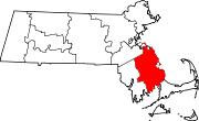
Towns Abington | Carver | Duxbury | East Bridgewater | Halifax | Hanover | Hanson | Hingham | Hull | Kingston | Lakeville | Marion | Marshfield | Mattapoisett | Middleborough | Norwell | Pembroke | Plymouth | Plympton | Rochester | Rockland | Scituate | Wareham | West Bridgewater | Whitman
CDPs Bridgewater | Duxbury | Green Harbor-Cedar Crest | Hanson | Hingham | Kingston | Marion Center | Marshfield | Marshfield Hills | Mattapoisett Center | Middleborough Center | North Lakeville | North Pembroke | North Plymouth | North Scituate | Ocean Bluff-Brant Rock | Onset | Plymouth Center | Scituate | South Duxbury | Wareham Center | West Wareham | Weweantic | White Island Shores
Other
villagesCategories:- Towns in Plymouth County, Massachusetts


Wikimedia Foundation. 2010.