- National Register of Historic Places listings in Franklin County, Maine
-
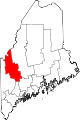
 Location of Franklin County in Maine
This is a list of the National Register of Historic Places listings in Franklin County, Maine.
This is intended to be a complete list of the properties and districts on the National Register of Historic Places in Franklin County, Maine, United States. Latitude and longitude coordinates are provided for many National Register properties and districts; these locations may be seen together in a Google map.[1]
There are 43 properties and districts listed on the National Register in the county (at least one property has been removed from the Register).
-
- This National Park Service list is complete through NPS recent listings posted November 10, 2011.[2]
Contents: Counties in Maine Androscoggin - Aroostook - Cumberland - Franklin - Hancock - Kennebec - Knox - Lincoln - Oxford - Penobscot - Piscataquis - Sagadahoc - Somerset - Waldo - Washington - York Contents
Current listings
[3] Landmark name [4] Image Date listed Location City or town Summary 1 Arnold Trail to Quebec October 1, 1969 Along the Kennebec River, through Wayman and Flagstaff lakes along the Dead River and Chain of Ponds to Quebec
44°40′49″N 69°59′18″W / 44.680278°N 69.988333°WCoburn Gore Extends through Franklin, Kennebec, Sagadahoc, and Somerset counties 2 Barn on Lot 8, Range G August 24, 2011 816 Foster Hill Rd.
44°51′29″N 70°13′20″W / 44.858056°N 70.222222°WFreeman Township 3 Bass Boarding House April 7, 1988 Canal St.
44°35′12″N 70°13′58″W / 44.586667°N 70.232778°WWilton 4 Ora Blanchard House January 15, 1980 Main St.
45°08′32″N 70°26′42″W / 45.142222°N 70.445°WStratton 5 John G. Coburn April 11, 2002 360 River Rd.
44°37′36″N 70°28′36″W / 44.626667°N 70.476667°WCarthage Perhaps the "John G. Coburn House"? 6 Coplin Plantation Schoolhouse September 11, 1997 State Route 16 approximately 4.5 miles southwest of its junction with State Route 27
45°05′32″N 70°29′55″W / 45.092222°N 70.498611°WCoplin Plantation 7 Cutler Memorial Library November 2, 1973 Academy and High Sts.
44°40′09″N 70°08′55″W / 44.669167°N 70.148611°WFarmington 8 Farmington Historic District January 20, 1995 Roughly bounded by High, Academy, Anson, and Grove Sts.
44°40′14″N 70°08′58″W / 44.670556°N 70.149444°WFarmington Boundary decrease (listed 4/27/2010) 9 First Congregational Church, United Church of Christ 
July 25, 1974 Main St.
44°40′04″N 70°09′00″W / 44.667778°N 70.15°WFarmington 10 Franklin County Courthouse 
October 6, 1983 Main and Anson Sts.
44°40′17″N 70°09′08″W / 44.671389°N 70.152222°WFarmington 11 Free Will Baptist Meetinghouse August 28, 1973 Main St.
44°40′08″N 70°09′03″W / 44.668889°N 70.150833°WFarmington 12 Goodspeed Memorial Library January 5, 1989 104 Main St.
44°35′16″N 70°13′51″W / 44.587778°N 70.230833°WWilton 13 Greenacre October 29, 1982 17 Court St.
44°40′24″N 70°08′53″W / 44.673333°N 70.148056°WFarmington 14 Chester Greenwood House July 12, 1978 State Route 27
44°39′39″N 70°08′52″W / 44.660833°N 70.147778°WFarmington 15 Holmes-Crafts Homestead April 26, 1973 Old N. Jay Rd. on State Route 4
44°31′08″N 70°13′28″W / 44.518889°N 70.224444°WNorth Jay 16 Frank Hutchins House December 29, 1986 High St.
44°57′05″N 70°09′54″W / 44.951389°N 70.165°WKingfield 17 Jay-Niles Memorial Library March 13, 1987 State Route 4
44°32′53″N 70°14′17″W / 44.548056°N 70.238056°WNorth Jay 18 Little Red Schoolhouse February 23, 1972 South of West Farmington on Wilton Rd.
44°37′52″N 70°09′16″W / 44.631111°N 70.154444°WWest Farmington 19 Madrid Village Schoolhouse December 14, 1995 Western side of Reeds Mills Rd., 0.05 miles north of its junction with State Route 4
44°51′53″N 70°27′45″W / 44.864722°N 70.4625°WMadrid 20 Maine Woods Office November 10, 1980 Main St.
44°49′27″N 70°20′55″W / 44.824167°N 70.348611°WPhillips 21 McCleary Farm April 7, 1989 S. Strong Rd.
44°45′50″N 70°12′34″W / 44.763889°N 70.209444°WStrong 22 Merrill Hall January 23, 1980 Maine and Academy Sts.
44°40′09″N 70°08′58″W / 44.669167°N 70.149444°WFarmington 23 New Sharon Bridge September 24, 1999 South of U.S. Route 2 over the Sandy River
44°38′16″N 70°00′56″W / 44.637778°N 70.015556°WNew Sharon 24 New Sharon Congregational Church June 20, 1985 State Route 134
44°38′10″N 70°00′50″W / 44.636111°N 70.013889°WNew Sharon 25 Nordica Homestead December 23, 1969 North of Farmington on Holly Rd. off State Route 27
44°41′42″N 70°08′43″W / 44.695°N 70.145278°WFarmington 26 North Jay Grange Store October 23, 1974 State Route 17
44°33′15″N 70°14′09″W / 44.554167°N 70.235833°WNorth Jay 27 William F. Norton House July 8, 1982 1 Stanley Ave.
44°57′39″N 70°09′06″W / 44.960833°N 70.151667°WKingfield 28 Old Union Meetinghouse October 30, 1973 U.S. Route 2
44°37′26″N 70°04′40″W / 44.623889°N 70.077778°WFarmington 29 Oquossoc Log Church July 19, 1984 State Route 4
44°58′00″N 70°46′14″W / 44.966667°N 70.770556°WRangeley 30 Orgone Energy Observatory January 29, 1999 Western side of Dodge Pond Rd., 0.65 miles north of the junction of State Routes 4/16
44°58′54″N 70°43′05″W / 44.981667°N 70.718056°WRangeley 31 Porter-Bell-Brackley Estate November 10, 1980 Lower Main St.
44°48′16″N 70°13′14″W / 44.804444°N 70.220556°WStrong 32 Hiram Ramsdell House 
December 4, 1973 High and Perham Sts.
44°40′17″N 70°08′59″W / 44.671389°N 70.149722°WFarmington 33 Rangeley Trust Company Building July 13, 1989 Main St.
44°57′50″N 70°38′32″W / 44.963889°N 70.642222°WRangeley 34 Rangeley Public Library 
July 12, 1978 Lake St.
44°57′53″N 70°38′38″W / 44.964722°N 70.643889°WRangeley 35 Salem Town House (Former) August 5, 2005 State Route 142
44°54′05″N 70°16′35″W / 44.901389°N 70.276389°WSalem 36 Temple Intervale School 
February 8, 1985 Temple Intervale
44°41′54″N 70°14′45″W / 44.698333°N 70.245833°WTemple 37 Thompson's Bridge March 22, 1991 Over Thompson's Creek off the northern side of State Route 43 at the Franklin-Somerset county line
44°43′36″N 70°00′25″W / 44.726667°N 70.006944°WAllen's Mills 38 Tufts House May 8, 1979 Southeast of Farmington on U.S. Route 2
44°38′10″N 70°05′35″W / 44.636111°N 70.093056°WFarmington 39 Union Church 
July 13, 1989 Main and Pleasant Sts.
44°49′24″N 70°20′23″W / 44.823333°N 70.339722°WPhillips 40 Upper Dallas School February 9, 1990 Saddleback Rd.
44°57′55″N 70°36′08″W / 44.965278°N 70.602222°WDallas Plantation 41 Weld Town Hall 
June 27, 2007 17 School St.
44°41′51″N 70°25′12″W / 44.6975°N 70.42°WWeld 42 Capt. Joel Whitney House April 22, 2003 8 Pleasant St.
44°49′22″N 70°20′24″W / 44.822778°N 70.34°WPhillips 43 Amos G. Winter House May 3, 1976 Winter's Hill off State Route 27
44°57′33″N 70°09′37″W / 44.959167°N 70.160278°WKingfield Former listings
Landmark name Image Date removed Location City or Town Summary 1 Jacob Abbott House 
April 27, 2010 State Route 27
44°39′56″N 70°8′52″W / 44.66556°N 70.14778°WFarmington Listed on the NRHP November 26, 1973 See also
References
- ^ The latitude and longitude information provided in this table was derived originally from the National Register Information System, which has been found to be fairly accurate for about 99% of listings. For about 1% of NRIS original coordinates, experience has shown that one or both coordinates are typos or otherwise extremely far off; some corrections may have been made. A more subtle problem causes many locations to be off by up to 150 yards, depending on location in the country: most NRIS coordinates were derived from tracing out latitude and longitudes off of USGS topographical quadrant maps created under the North American Datum of 1927, which differs from the current, highly accurate WGS84 GPS system used by Google maps. Chicago is about right, but NRIS longitudes in Washington are higher by about 4.5 seconds, and are lower by about 2.0 seconds in Maine. Latitudes differ by about 1.0 second in Florida. Some locations in this table may have been corrected to current GPS standards.
- ^ "National Register of Historic Places: Weekly List Actions". National Park Service, United States Department of the Interior. Retrieved on November 10, 2011.
- ^ Numbers represent an ordering by significant words. Various colorings, defined here, differentiate National Historic Landmark sites and National Register of Historic Places Districts from other NRHP buildings, structures, sites or objects.
- ^ "National Register Information System". National Register of Historic Places. National Park Service. . http://nrhp.focus.nps.gov/natreg/docs/All_Data.html.
U.S. National Register of Historic Places Topics Lists by states Alabama • Alaska • Arizona • Arkansas • California • Colorado • Connecticut • Delaware • Florida • Georgia • Hawaii • Idaho • Illinois • Indiana • Iowa • Kansas • Kentucky • Louisiana • Maine • Maryland • Massachusetts • Michigan • Minnesota • Mississippi • Missouri • Montana • Nebraska • Nevada • New Hampshire • New Jersey • New Mexico • New York • North Carolina • North Dakota • Ohio • Oklahoma • Oregon • Pennsylvania • Rhode Island • South Carolina • South Dakota • Tennessee • Texas • Utah • Vermont • Virginia • Washington • West Virginia • Wisconsin • WyomingLists by territories Lists by associated states Other Municipalities and communities of Franklin County, Maine Towns Avon | Carrabassett Valley | Carthage | Chesterville | Eustis | Farmington | Industry | Jay | Kingfield | New Sharon | New Vineyard | Phillips | Rangeley | Strong | Temple | Weld | Wilton
Plantations Unorganized
territoriesCDPs Chisholm | Farmington | Wilton
Village Categories:- National Register of Historic Places in Maine by county
- Franklin County, Maine
-


Wikimedia Foundation. 2010.