- National Register of Historic Places listings in Delta County, Colorado
-
 Location of Delta County in Colorado
This is a list of the National Register of Historic Places listings in Delta County, Colorado. It is intended to be a complete list of the properties and districts on the National Register of Historic Places in Delta County, Colorado, United States. The locations of National Register properties and districts for which the latitude and longitude coordinates are included below, may be seen in a Google map.[1]
There are 14 properties and districts listed on the National Register in the county.
-
- This National Park Service list is complete through NPS recent listings posted November 10, 2011.[2]
Listings county-wide
[3] Landmark name [4] Image Date listed Location City or town Summary 1 Curtis Hardware Store October 19, 1989 228 Grand Ave.
38°52′05″N 107°35′52″W / 38.868056°N 107.597778°WPaonia 2 Delta County Bank Building June 24, 1993 301 and 305 Main St.
38°44′34″N 108°04′14″W / 38.742778°N 108.070556°WDelta 3 Egyptian Theater July 12, 1993 452 Main St.
38°44′27″N 108°04′11″W / 38.740833°N 108.069722°WDelta 4 Ferganchick Orchard Rock Art Site May 9, 1983 Address Restricted Austin 5 First Methodist Episcopal Church of Delta February 20, 1991 199 E. 5th St.
38°44′25″N 108°04′09″W / 38.740278°N 108.069167°WDelta 6 First Presbyterian Church of Eckert January 11, 2006 13011 and 13025 State Highway 65
38°49′42″N 107°58′14″W / 38.828333°N 107.970556°WEckert 7 Garnethurst November 7, 1995 509 Leon St.
38°44′25″N 108°03′45″W / 38.740278°N 108.0625°WDelta 8 Hotchkiss Hotel September 20, 1984 101 Bridge St.
38°47′57″N 107°43′09″W / 38.799167°N 107.719167°WHotchkiss 9 Hotchkiss Methodist Episcopal Church October 28, 2009 285 N. 2nd St.
38°47′59″N 107°43′10″W / 38.799736°N 107.719356°WHotchkiss 10 Mathews House October 6, 2004 40647 Matthews Ln.
38°51′54″N 107°36′05″W / 38.865°N 107.601389°WPaonia 11 Paonia First Christian Church April 27, 2011 235 Box Elder Ave.
38°52′05″N 107°35′39″W / 38.868056°N 107.594167°WPaonia 12 Stolte House November 17, 1997 1812 State Highway 65
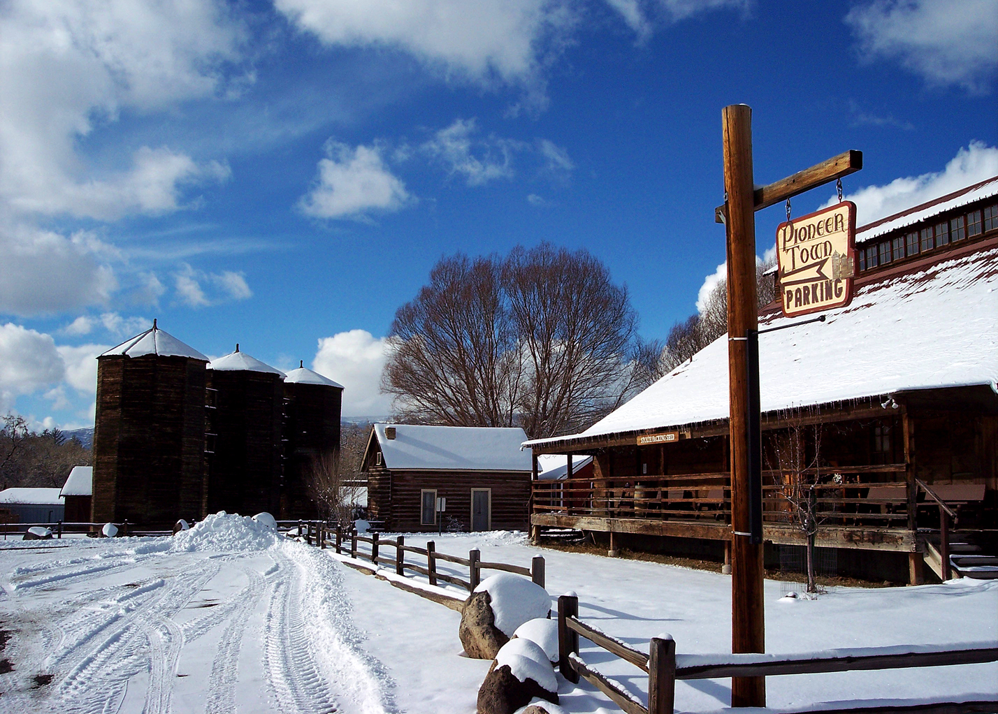
38°55′03″N 107°55′21″W / 38.9175°N 107.9225°WCedaredge 13 Surface Creek Livestock Company Silos 
April 27, 2000 315 SW. 3rd St.
38°53′57″N 107°55′30″W / 38.899167°N 107.925°WCedaredge 14 US Post Office and Federal Building-Delta Main January 24, 1986 360 Meeker St.
38°44′31″N 108°04′06″W / 38.741944°N 108.068333°WDelta See also
- List of National Historic Landmarks in Colorado
- National Register of Historic Places listings in Colorado
References
- ^ The latitude and longitude information provided in this table was derived originally from the National Register Information System, which has been found to be fairly accurate for about 99% of listings. For about 1% of NRIS original coordinates, experience has shown that one or both coordinates are typos or otherwise extremely far off; some corrections may have been made. A more subtle problem causes many locations to be off by up to 150 yards, depending on location in the country: most NRIS coordinates were derived from tracing out latitude and longitudes off of USGS topographical quadrant maps created under the North American Datum of 1927, which differs from the current, highly accurate WGS84 GPS system used by Google maps. Chicago is about right, but NRIS longitudes in Washington are higher by about 4.5 seconds, and are lower by about 2.0 seconds in Maine. Latitudes differ by about 1.0 second in Florida. Some locations in this table may have been corrected to current GPS standards.
- ^ "National Register of Historic Places: Weekly List Actions". National Park Service, United States Department of the Interior. Retrieved on November 10, 2011.
- ^ Numbers represent an ordering by significant words. Various colorings, defined here, differentiate National Historic Landmark sites and National Register of Historic Places Districts from other NRHP buildings, structures, sites or objects.
- ^ "National Register Information System". National Register of Historic Places. National Park Service. . http://nrhp.focus.nps.gov/natreg/docs/All_Data.html.
U.S. National Register of Historic Places Topics Lists by states Alabama • Alaska • Arizona • Arkansas • California • Colorado • Connecticut • Delaware • Florida • Georgia • Hawaii • Idaho • Illinois • Indiana • Iowa • Kansas • Kentucky • Louisiana • Maine • Maryland • Massachusetts • Michigan • Minnesota • Mississippi • Missouri • Montana • Nebraska • Nevada • New Hampshire • New Jersey • New Mexico • New York • North Carolina • North Dakota • Ohio • Oklahoma • Oregon • Pennsylvania • Rhode Island • South Carolina • South Dakota • Tennessee • Texas • Utah • Vermont • Virginia • Washington • West Virginia • Wisconsin • WyomingLists by territories Lists by associated states Other Municipalities and communities of Delta County, Colorado City 
Towns Cedaredge | Crawford | Hotchkiss | Orchard City | Paonia
Unincorporated
communitiesCategories:- National Register of Historic Places in Colorado by county
- Delta County, Colorado
- Buildings and structures in Delta County, Colorado
-

Wikimedia Foundation. 2010.