- National Register of Historic Places listings in Cascade County, Montana
-
 Location of Cascade County in Montana
This is a list of the National Register of Historic Places listings in Cascade County, Montana. It is intended to be a complete list of the properties and districts on the National Register of Historic Places in Cascade County, Montana, United States. The locations of National Register properties and districts for which the latitude and longitude coordinates are included below, may be seen in a Google map.[1]
There are 41 properties and districts listed on the National Register in the county, including 2 National Historic Landmarks.
-
- This National Park Service list is complete through NPS recent listings posted November 10, 2011.[2]
Listings county-wide
[3] Landmark name Image Date listed Location City or town Summary 1 J.C. Adam's Stone Barn January 12, 1979 Northeast of Sun River off U.S. Route 81
47°32′25″N 111°41′11″W / 47.540278°N 111.686389°WSun River 2 Arvon Block September 26, 1991 114-116 1st Ave., S.
47°30′14″N 111°18′15″W / 47.503889°N 111.304167°WGreat Falls 3 Belt Commercial Historic District December 23, 2004 Castner St.
47°23′12″N 110°55′39″W / 47.386667°N 110.9275°WBelt 4 Belt Jail March 10, 1980 Castner St.
47°23′08″N 110°55′40″W / 47.385556°N 110.927778°WBelt 5 Burlingame School June 1, 1992 Address Restricted Belt 6 Cascade County Courthouse April 16, 1980 415 2nd Ave., N.
47°30′29″N 111°17′58″W / 47.508056°N 111.299444°WGreat Falls 7 Chicago, Milwaukee and St. Paul Passenger Depot 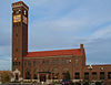
October 13, 1988 River Dr., N.
47°30′25″N 111°18′29″W / 47.506944°N 111.308056°WGreat Falls 8 Timothy Edwards Collins Mansion August 27, 1980 1003-1017 2nd Ave., NW.
47°30′36″N 111°19′43″W / 47.51°N 111.328611°WGreat Falls 9 Crocker-Jarvi Homestead June 1, 1992 Address Restricted Belt 10 First United Methodist Church Parsonage December 23, 2003 113 6th St., N.
47°30′26″N 111°17′47″W / 47.507222°N 111.296389°WGreat Falls 11 Lee M. Ford House August 10, 1990 401 4th Ave., N.
47°30′37″N 111°18′00″W / 47.510278°N 111.3°WGreat Falls 12 Fort Shaw Historic District and Cemetery January 11, 1985 1 mile northwest of Fort Shaw
47°30′36″N 111°49′13″W / 47.51°N 111.820278°WFort Shaw 13 Great Falls Central Business Historic District August 20, 2004 2nd Ave., N., 1st Ave., N., Central Ave., and 1st Ave., S.
47°30′21″N 111°17′54″W / 47.505833°N 111.298333°WGreat Falls 14 Great Falls Central High School 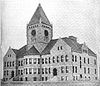
September 1, 1976 1400 1st Ave., N.
47°30′21″N 111°16′55″W / 47.505833°N 111.281944°WGreat Falls 15 Great Falls Northside Residential Historic District April 1, 1991 200-900 blocks of 4th Ave., N., the 100-900 blocks of 3rd Ave., N., and the 500-900 blocks of 2nd Ave., N.
47°30′32″N 111°17′50″W / 47.508889°N 111.297222°WGreat Falls 16 Great Falls Portage October 15, 1966 Southeast of Great Falls at the junction of U.S. Routes 87, 89, and 91
47°31′52″N 111°09′05″W / 47.531111°N 111.151389°WGreat Falls 17 Great Falls Railroad Historic District February 19, 1993 Park and River Drs., the 100-400 blocks of 2nd St., S., the 100-200 blocks of 1st and 2nd Aves., S., and the 100-300 blocks of 3rd St., S.
47°30′14″N 111°17′48″W / 47.503889°N 111.296667°WGreat Falls 18 Great Falls West Bank Historic District August 30, 2010 300 and 400 blocks of 3rd St. NW
47°30′44″N 111°18′58″W / 47.512222°N 111.316111°WGreat Falls 19 Hardy Bridge January 4, 2010 Milepost 6 on Old U.S. Route 91
47°10′01″N 111°50′04″W / 47.166892°N 111.834433°WCascade 20 Heikkila-Mattila Homestead June 1, 1992 Address Restricted Belt 21 Kraftenberg Homestead June 1, 1992 Address Restricted Belt 22 Lewis-Nevala Homestead June 1, 1992 Address Restricted Belt 23 Margaret Block August 2, 1984 413-415 Central Ave.
47°30′20″N 111°17′57″W / 47.505556°N 111.299167°WGreat Falls 24 Masonic Temple December 28, 2000 821 Central Ave.
47°30′26″N 111°17′32″W / 47.507222°N 111.292222°WGreat Falls 25 Mullan Road March 13, 1975 North of Great Falls in the Benton Lake National Wildlife Refuge
47°41′49″N 111°19′10″W / 47.696944°N 111.319444°WGreat Falls Extends into Benewah and Kootenai counties in Idaho 26 Neihart School March 7, 2003 200 S. Main St.
46°55′45″N 110°43′51″W / 46.929167°N 110.730833°WNeihart 27 Northern Montana State Fairground Historic District January 13, 1989 3rd St., NW.
47°30′40″N 111°19′03″W / 47.511111°N 111.3175°WGreat Falls 28 Harry E. Randall House March 27, 1986 1003 4th Ave., N.
47°30′36″N 111°17′21″W / 47.51°N 111.289167°WGreat Falls 29 Roberts Building September 12, 1985 520-526 Central Ave.
47°30′18″N 111°17′49″W / 47.505°N 111.296944°WGreat Falls 30 Charles M. Russell House and Studio October 15, 1966 1217-1219 4th Ave., N.
47°30′36″N 111°17′05″W / 47.51°N 111.284722°WGreat Falls 31 Charlie and Nancy Russell Honeymoon Cabin December 16, 2005 20 Russell Dr., S.
47°16′12″N 111°41′53″W / 47.27°N 111.698056°WCascade 32 St. Peter's Mission Church and Cemetery August 3, 1984 West of Cascade
47°18′02″N 111°55′14″W / 47.300556°N 111.920556°WCascade 33 Stone Homestead June 1, 1992 Address Restricted Belt 34 Tenth Street Bridge 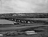
April 25, 1996 10th St. across the Missouri River
47°31′20″N 111°17′22″W / 47.522222°N 111.289444°WGreat Falls 35 Tower Rock March 18, 2002 8 miles south of Cascade at Interstate 15 interchange 247
47°11′00″N 111°48′51″W / 47.183333°N 111.814167°WCascade 36 Ulm Pishkun December 17, 1974 Address Restricted Ulm 37 Union Bethel African Methodist Episcopal Church September 11, 2003 916 5th Ave., S.
47°29′58″N 111°17′25″W / 47.499444°N 111.290278°WGreat Falls 38 Ursuline Academy September 26, 1991 2300 Central Ave.
47°30′15″N 111°15′58″W / 47.504167°N 111.266111°WGreat Falls 39 US Post Office and Courthouse-Great Falls March 14, 1986 215 1st Ave., N.
47°30′24″N 111°18′11″W / 47.506667°N 111.303056°WGreat Falls 40 Robert Vaughn Homestead June 14, 1982 Vaughn Cemetery Rd. (Cascade County Rd.)
47°32′58″N 111°33′14″W / 47.549444°N 111.553889°WVaughn 41 Wargelin-Warila Homestead June 1, 1992 Address Restricted Belt See also
- List of National Historic Landmarks in Montana
- National Register of Historic Places listings in Montana
References
- ^ The latitude and longitude information provided in this table was derived originally from the National Register Information System, which has been found to be fairly accurate for about 99% of listings. For about 1% of NRIS original coordinates, experience has shown that one or both coordinates are typos or otherwise extremely far off; some corrections may have been made. A more subtle problem causes many locations to be off by up to 150 yards, depending on location in the country: most NRIS coordinates were derived from tracing out latitude and longitudes off of USGS topographical quadrant maps created under the North American Datum of 1927, which differs from the current, highly accurate WGS84 GPS system used by Google maps. Chicago is about right, but NRIS longitudes in Washington are higher by about 4.5 seconds, and are lower by about 2.0 seconds in Maine. Latitudes differ by about 1.0 second in Florida. Some locations in this table may have been corrected to current GPS standards.
- ^ "National Register of Historic Places: Weekly List Actions". National Park Service, United States Department of the Interior. Retrieved on November 10, 2011.
- ^ Numbers represent an ordering by significant words. Various colorings, defined here, differentiate National Historic Landmark sites and National Register of Historic Places Districts from other NRHP buildings, structures, sites or objects.
U.S. National Register of Historic Places Topics Lists by states Alabama • Alaska • Arizona • Arkansas • California • Colorado • Connecticut • Delaware • Florida • Georgia • Hawaii • Idaho • Illinois • Indiana • Iowa • Kansas • Kentucky • Louisiana • Maine • Maryland • Massachusetts • Michigan • Minnesota • Mississippi • Missouri • Montana • Nebraska • Nevada • New Hampshire • New Jersey • New Mexico • New York • North Carolina • North Dakota • Ohio • Oklahoma • Oregon • Pennsylvania • Rhode Island • South Carolina • South Dakota • Tennessee • Texas • Utah • Vermont • Virginia • Washington • West Virginia • Wisconsin • WyomingLists by territories Lists by associated states Other Municipalities and communities of Cascade County, Montana City 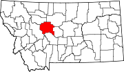
Towns CDPs Black Eagle | Fort Shaw | Malmstrom AFB | Simms | Sun Prairie | Sun River | Ulm | Vaughn
Unincorporated
communityCategories:- National Register of Historic Places in Montana by county
- Cascade County, Montana
-


Wikimedia Foundation. 2010.