- Niagara Escarpment
-
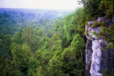
 Rattlesnake Point near Milton, Ontario.
 Blue Mountains near Collingwood, Ontario.
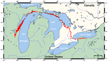 Niagara Escarpment (in red)
The Niagara Escarpment is a long escarpment, or cuesta, in the United States and Canada that runs westward from New York State, through Ontario, Michigan, Wisconsin and Illinois. It is composed of the Lockport geological formation of Silurian age, and is similar to the Onondaga geological formation, which runs parallel to it and just to the south, through western New York and southern Ontario. The escarpment is most famous as the cliff over which the Niagara River plunges at Niagara Falls, for which it is named.
The Niagara Escarpment is the most prominent of several escarpments formed in the bedrock of the Great Lakes basin. From its easternmost point near Watertown, New York[1], the escarpment shapes in part the individual basins and landforms of Lakes Ontario, Huron and Michigan. In Rochester, New York, there are three waterfalls over the escarpment where the Genesee River flows through the city. The escarpment thence runs westward to the Niagara River forming a deep gorge north of Niagara Falls, which itself cascades over the escarpment. In southern Ontario it spans the Niagara Peninsula, closely following the Lake Ontario shore through the cities of St. Catharines, Hamilton and Dundas, where it takes a sharp turn north in the town of Milton toward Georgian Bay. It then follows the Georgian Bay shore northwestwards to form the spine of the Bruce Peninsula and Manitoulin Island, as well as several smaller islands located in northern Lake Huron where it turns westwards into the Upper Peninsula of northern Michigan, south of Sault Ste. Marie. It then extends southwards into Wisconsin following the Door Peninsula through the Bayshore Blufflands and then more inland from the western coast of Lake Michigan and Milwaukee ending northwest of Chicago near the Wisconsin-Illinois border.
Contents
Formation
 Niagara Escarpment in Grimsby, Ontario from approx 3500 feet above sea level
 Hamilton Skyline, view from atop the Niagara Escarpment
 A section of escarpment cliff, seen from the Bruce Trail in Ontario.
 Calumet County, Wisconsin
Study of rock exposures and drillholes demonstrates that there is no displacement of the rock layers at the escarpment: this is not a fault line but the result of unequal erosion. The escarpment's caprock is dolomitic limestone ("dolostone"), which is more resistant and overlies weaker, more easily eroded shale as a weathering-resistant "cap". The escarpment thus formed over millions of years through a process of differential erosion of rocks of different hardnesses. Through time the soft rocks weather away or erode by the action of streams. The gradual removal of the soft rocks undercuts the resistant caprock, leaving a cliff or escarpment. The erosional process is most readily seen at Niagara Falls, where the river has quickened the process. It can also be seen at the three waterfalls of the Genesee River at Rochester (additional resistant rock layers make more than one escarpment in some places). Also, in some places thick glacial deposits conceal the Niagara Escarpment, such as north of Georgetown, Ontario, where it actually continues under glacial till and reappears farther north.
The dolostone cap was laid down as sediment on the floor of a marine environment. In Michigan, behind (i.e., southwest of) the escarpment, the cuesta capstone slopes gently to form a wide basin, the floor of an Ordovician-Silurian age tropical sea. (The escarpment essentially represents the remnant shoreline of that sea.) There the constant depositing of minute shells and fragments of biologically-generated calcium carbonate, mixed with sediment washing in by erosion of the virtually lifeless landmasses eventually formed a limestone layer. During the Silurian period, some magnesium substituted for some of the calcium in the carbonates, slowly forming harder (dolomitic) sedimentary strata in the same fashion. Worldwide sea levels were at their all-time maximum in the Ordovician; as the sea retreated, erosion inevitably began.[2]
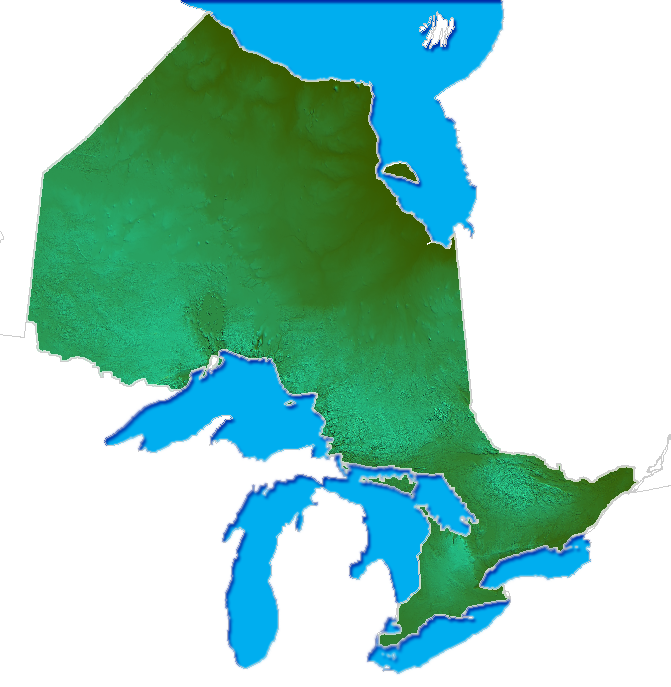
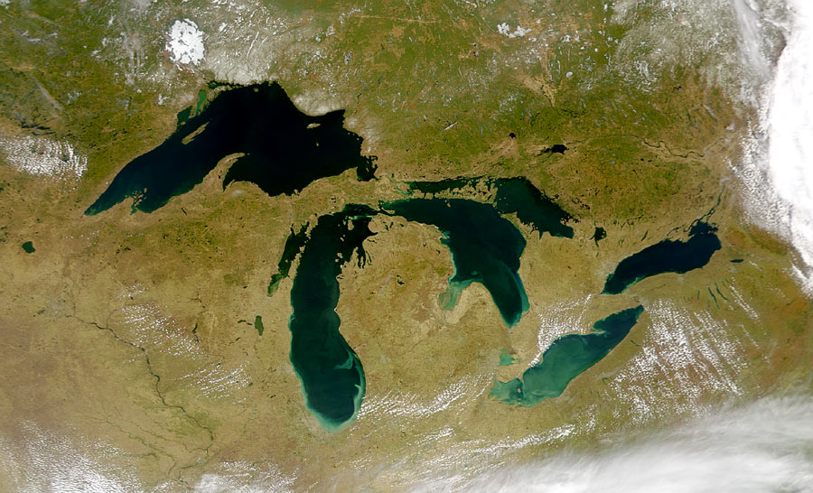
This dolostone basin contains Lakes Michigan, Huron and Erie. (The geological formations under Lakes Superior and Ontario were formed from volcanic rifts. Soft basalt line its canyon walls, bottoming at 1300 feet below sea level.)
Human geography
The Welland Canal allows ships to traverse the Escarpment between Lake Erie and Lake Ontario on the Niagara Peninsula of Ontario. The escarpment was a major obstacle in the construction of the Erie Canal in New York and was traversed by a series of locks; the community which grew up at the site thus became known as Lockport, New York.
In southern Ontario, the Bruce Trail runs the length of the escarpment from Queenston on the Niagara River to Tobermory on the Bruce Peninsula. Highway 401, Canada's busiest, also crosses the Niagara Escarpment, beginning its long descent through rolling hills, farmland, and towns west of Milton. Rock exposed on the face of the escarpment can be seen along Highway 26 (Ontario) from Owen Sound eastwards towards Meadford, Ontario.
Hamilton, Ontario, is situated on the escarpment in such a way that the North end of the city is below and the South part above. Affectionately referred to as "The Mountain" by its residents, there are a number of roads or "mountain accesses" that join the urban core below with the suburban expansion above.
High Cliff State Park in Wisconsin shows how modern and prehistoric humans used the escarpment for not only cultural reasons but economic gains as well. There are a number of different animal and geometric effigy mounds, and the remains of a turn-of-the-century limestone quarry and kiln within the park.
The relief and exposed edge is used by windmill farms stretching from Pipe, Wisconsin to Brownsville, Wisconsin. Wind speeds average 18 mph along this stretch.
Many resorts and ski areas in Ontario, Michigan, Wisconsin and New York are located along the Escarpment.
Vineyard land
On the Canadian side of the border the Niagara Escarpment is a group-sub-appellation comprising the Short Hills Bench, The 20 Mile Bench and the Beamsville Bench. On the US side of the border is the American Viticultural Area of Niagara Escarpment AVA.
World Biosphere Reserve
In February 1990, the Niagara Escarpment was designated a World Biosphere Reserve by UNESCO, making it one of 12 in Canada. Development and land use on and adjacent to the escarpment is regulated by the Niagara Escarpment Commission, an agency of the Ontario government.[3]
See also
- Ontario Greenbelt
- Oak Ridges Moraine
- Canadian Shield
- Cheltenham Badlands
- Onondaga Escarpment
Notes
- ^ http://www.waterkeeper.ca/2010/12/03/niagara-escarpment/?printerFriendly
- ^ The Niagara Escarpment
- ^ "Biosphere Reserve Information - Canada - Niagara Escarpment Biosphere Reserve". MAB Biosphere Reserves Directory. UNESCO. http://www.unesco.org/mabdb/br/brdir/directory/biores.asp?mode=all&code=CAN+06. Retrieved 2009-05-03.
External links
Protected areas in Ontario National parks 
Provincial parks Conservation areas Boyd · Claireville · Cold Creek · Guelph Lake · Heber Down · Kortright Centre · Lake Laurentian · Mer Bleue · Mount Nemo · Rattlesnake Point · Spencer Gorge / Webster's Falls · more...UNESCO Biosphere Reserves Georgian Bay Littoral · Long Point · Niagara Escarpment (including Cheltenham Badlands) · Thousand Islands - Frontenac Arch · Wasaga BeachNational Historic Sites of Canada Central Experimental Farm · Dundurn Castle · Laurier House · Massey Hall · Montgomery's Tavern · Osgoode Hall · Parliament · Rideau Canal · Rideau Hall · more...Other areas Great Lakes of North America Main lakes 
Secondary lakes Waterways Detroit River • Erie Canal • French River • Great Lakes Waterway • Niagara River • Nipigon River • St. Clair River • Saint Lawrence River • Saint Lawrence Seaway • St. Marys River • Soo Locks • Straits of Mackinac • Trent–Severn Waterway • Welland CanalLists of islands Historic geology Lake Agassiz • Lake Chicago • Lake Maumee • Mackinac Falls • Niagara Escarpment • Wisconsin glaciationLakeshores Related topics Basin • Bays of the Great Lakes • Great Lakes region • Georgian Bay • Great Lake ships • Isle Royale • Lake effect • Manitoulin Island • Megalopolis • Quebec City – Windsor Corridor • Settlements • Shipwrecks • Tall shipsCategories:- Niagara Escarpment
- Geology of the United States
- Historical geology of the Great Lakes
- Stratigraphy of Ontario
- Geography of Niagara County, New York
- Geography of Illinois
- Geography of Michigan
- Geography of Wisconsin
- Escarpments of Canada
- Escarpments of the United States


Wikimedia Foundation. 2010.