- Coto de Caza, California
-
Coto de Caza — census-designated place — Location of Coto de Caza within Orange County, California.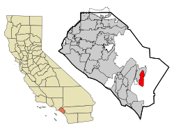
Coordinates: 33°35′45″N 117°35′16″W / 33.59583°N 117.58778°WCoordinates: 33°35′45″N 117°35′16″W / 33.59583°N 117.58778°W Country  United States
State  California
County Orange Area[1] - Total 7.974 sq mi (20.653 km2) - Land 7.951 sq mi (20.593 km2) - Water 0.023 sq mi (0.061 km2) 0.29% Elevation 709 ft (216 m) Population (2010) - Total 14,866 - Density 1,864.3/sq mi (719.8/km2) Time zone PST (UTC-8) - Summer (DST) PDT (UTC-7) ZIP code 92679 Area code(s) 949 FIPS code 06-16580 GNIS feature ID 1867008 Coto de Caza (meaning game preserve in Spanish) is a census-designated place (CDP) and guard-gated private community in Orange County, California. The population was 14,866 at the 2010 census, up from 13,057 at the 2000 census.
The CDP is a suburban planned community of about 4,000 homes, and one of Orange County's oldest and most expensive master planned communities. The project began in 1968, when it was envisioned as a hunting lodge, now the Lodge at Coto de Caza, and the community was completed in 2003. For the 1984 Summer Olympics, the community served as host to the riding, running, shooting, and fencing portions of the modern pentathlon events.[2] Around the town there are still undeveloped lots available for purchase. Currently there are two 18-hole golf courses, and two club houses, one considered the "old club" and the other the "new club." The new club, the Coto De Caza Golf & Racquet Club, harbors the facilities of the two golf courses and adjacent ten tennis courts. The old club, located in the residential area known as "the Village," was once home to tennis guru and teacher Vic Braden. The old club was also the home location for the Coto de Caza Youth Swim Team. The new club finished construction of the new Spa & Sports Club building in April 2008 that houses a new fitness center with state-of-the-art StarTrac exercise equipment, a spa with many services, a snack bar with Starbuck's coffee, and the Michael Chang tennis hall of fame and member lounge. The golf courses are both Robert Trent Jones Jr. design. The North course was rated the most difficult golf course in all of Orange County.
The community is the setting of the reality-based television show The Real Housewives of Orange County on Bravo.
Coto de Caza contains commercial endeavors, Lodge at Coto de Caza, The Coto de Caza Golf and Racquet Club, & The Coto de Caza General Store. Residents shop in Rancho Santa Margarita, Mission Viejo, Las Flores, or Ladera Ranch. Most students in Coto de Caza reside in the Capistrano Unified School District and attend Wagon Wheel Elementary, Tijeras Creek Elementary, Las Flores Middle School, Tesoro High School, and Santa Margarita Catholic High School (not part of Capistrano Unified). The majority of the community is tract housing, with collections of custom-built homes on the outskirts off the main streets. Coto de Caza is twenty minutes from the San Diego Freeway (Interstate 5) and five minutes from the Foothill Toll Road (State Route 241) to Irvine and then Riverside County.
While some residents believe that "Coto de Caza" means "Preserve of the Hunt" in Portuguese, this is erroneous. Actually, "Coto de Caza" is Spanish for "Hunt Reserve" and implies that the reserve is private.
Contents
Geography
Coto de Caza is located at 33°35′45″N 117°35′16″W / 33.59583°N 117.58778°W (33.595925, -117.587665).[3]
According to the United States Census Bureau, the CDP has a total area of 8.0 square miles (21 km2), of which, 8.0 square miles (21 km2) of it is land and 0.02 square miles (0.052 km2) of it (0.29%) is water.
Demographics
Historical populations Census Pop. %± 1990 2,853 — 2000 13,057 357.7% 2010 14,866 13.9% source:[4] 2010
The 2010 United States Census[5] reported that Coto de Caza had a population of 14,866. The population density was 1,864.2 people per square mile (719.8/km²). The racial makeup of Coto de Caza was 13,094 (88.1%) White, 132 (0.9%) African American, 26 (0.2%) Native American, 878 (5.9%) Asian, 20 (0.1%) Pacific Islander, 174 (1.2%) from other races, and 542 (3.6%) from two or more races. Hispanic or Latino of any race were 1,170 persons (7.9%).
The Census reported that 14,866 people (100% of the population) lived in households, 0 (0%) lived in non-institutionalized group quarters, and 0 (0%) were institutionalized.
There were 4,736 households, out of which 2,407 (50.8%) had children under the age of 18 living in them, 3,763 (79.5%) were opposite-sex married couples living together, 294 (6.2%) had a female householder with no husband present, 133 (2.8%) had a male householder with no wife present. There were 96 (2.0%) unmarried opposite-sex partnerships, and 30 (0.6%) same-sex married couples or partnerships. 420 households (8.9%) were made up of individuals and 116 (2.4%) had someone living alone who was 65 years of age or older. The average household size was 3.14. There were 4,190 families (88.5% of all households); the average family size was 3.35.
The population was spread out with 4,545 people (30.6%) under the age of 18, 996 people (6.7%) aged 18 to 24, 2,706 people (18.2%) aged 25 to 44, 5,452 people (36.7%) aged 45 to 64, and 1,167 people (7.9%) who were 65 years of age or older. The median age was 42.2 years. For every 100 females there were 96.8 males. For every 100 females age 18 and over, there were 95.1 males.
There were 4,853 housing units at an average density of 608.6 per square mile (235.0/km²), of which 4,341 (91.7%) were owner-occupied, and 395 (8.3%) were occupied by renters. The homeowner vacancy rate was 1.0%; the rental vacancy rate was 1.5%. 13,738 people (92.4% of the population) lived in owner-occupied housing units and 1,128 people (7.6%) lived in rental housing units.
2000
As of the census[6] of 2000, there were 13,057 people, 4,049 households, and 3,644 families residing in the CDP. The population density was 1,654.5 inhabitants per square mile (639.0/km²). There were 4,152 housing units at an average density of 526.1 per square mile (203.2/km²). The racial makeup of the CDP was 89.36% White, 0.74% Black or African American, 0.15% Native American, 5.16% Asian, 0.15% Pacific Islander, 1.65% from other races, and 2.80% from two or more races. 6.65% of the population were Hispanic or Latino of any race.
There were 4,049 households out of which 56.1% had children under the age of 18 living with them, 83.4% were married couples living together, 4.1% had a female householder with no husband present, and 10.0% were non-families. 7.5% of all households were made up of individuals and 1.1% had someone living alone who was 65 years of age or older. The average household size was 3.22 and the average family size was 3.40.
In the CDP the population was spread out with 35.1% under the age of 18, 4.0% from 18 to 24, 33.4% from 25 to 44, 23.8% from 45 to 64, and 3.7% who were 65 years of age or older. The median age was 35 years. For every 100 females there were 99.6 males. For every 100 females age 18 and over, there were 97.4 males.
The median income for a household in the CDP was $136,726, and the median income for a family was $141,598. Males had a median income of $97,803 versus $50,689 for females. The per capita income for the CDP was $55,900. About 0.7% of families and 0.9% of the population were below the poverty line, including 0.7% of those under age 18 and none of those age 65 or over.
Education
The CDP is served by Capistrano Unified School District. Students attend Tijeras Creek Elementary, Wagon Wheel Elementary,[7] Las Flores Middle School or Tesoro High School. St. John's Episcopal School and Serra Catholic Schools are private elementary, and middle schools located outside the gates. Santa Margarita Catholic High School is located at the North Gate.
An attempt to build a 400-student public school within the walls of the community was rebuffed by the residents.[7] The residents had concerns that it would "undermine the privacy and security" of the enclave, that it would be "downright illegal [to place a public school on a gated private property]", that it would force admission of large numbers of non-residents to the community, and that an eventual lawsuit would force the removal of the gates.[7] The reason for proposal was that Wagon Wheel Elementary School, which is located immediately outside the community gates, had far more students than planned.[7] The school equipment was to consist of 20 portable buildings which would have simply been added to Wagon Wheel if the new school's construction could not be completed.[7] Had it been built, it would have become the first public school to be built inside the limits of a gated community.[7]
The Thomas F. Riley Wilderness Park
The Thomas F. Riley Wilderness Park, which is open to the general public except after rain, surrounds the community of Coto de Caza on its eastern, northern, and southern borders. The park is a Wildlife and Plant Sanctuary and is known for its biological diversity. It is known for its oak groves, sycamores, and two creeks. The park is home to mountain lions, that have been known to attack when provoked, without warning. It is nearly 500 acres (2.0 km2) in size. It features approximately 6 miles (9.7 km) of equestrian, hiking, and biking trails. Inside the nature center it houses an educational center for outdoor education for local schools and community groups. It also serves as an ecological preserve for the native endangered plant and animal species. It is maintained and paid for by Orange County Parks, and is administered by Park Rangers and maintenance staff.
Politics
In the state legislature Coto de Caza is located in the 33rd Senate District, represented by Republican Mimi Walters, and in the 71st Assembly District, represented by Republican Jeff Miller. Federally, Coto de Caza is located in California's 44th congressional district, which has a Cook PVI of R +6[8] and is represented by Republican Ken Calvert.
Coto de Caza gave more than 65 percent support to Proposition 8 in 2008.[9]
The area is patrolled by the California Highway Patrol, Orange County Sheriff's Department, and the Coto de Caza Security Force.
Notable natives and residents
- Peter Vidmar, Olympic Medalist in Gymnastics (2 golds, 1 silver)
- Rob Bourdon, drummer for the band Linkin Park.
- Dave "Phoenix" Farrell, bassist for the band Linkin Park.[10]
- Teemu Selänne, professional Finnish ice hockey player and Stanley Cup Champion
- Michael Chang, former French Open singles champion at age 17
- Rod Carew, baseball Hall of Famer
- Paul Goydos, PGA Tour Professional
- Bobby Grich, retired Angels second baseman
- Jim Everett, retired Los Angeles Rams quarterback
- Linda Blair, actress with most notable role in the movie Exorcist
See also
References
- ^ U.S. Census
- ^ 1984 Summer Olympics official report. Volume 1. Part 1. pp. 140-3.
- ^ "US Gazetteer files: 2010, 2000, and 1990". United States Census Bureau. 2011-02-12. http://www.census.gov/geo/www/gazetteer/gazette.html. Retrieved 2011-04-23.
- ^ "CENSUS OF POPULATION AND HOUSING (1790-2000)". U.S. Census Bureau. http://www.census.gov/prod/www/abs/decennial/index.html. Retrieved 2010-07-17.
- ^ All data are derived from the United States Census Bureau reports from the 2010 United States Census, and are accessible on-line here. The data on unmarried partnerships and same-sex married couples are from the Census report DEC_10_SF1_PCT15. All other housing and population data are from Census report DEC_10_DP_DPDP1. Both reports are viewable online or downloadable in a zip file containing a comma-delimited data file. The area data, from which densities are calculated, are available on-line here. Percentage totals may not add to 100% due to rounding. The Census Bureau defines families as a household containing one or more people related to the householder by birth, opposite-sex marriage, or adoption. People living in group quarters are tabulated by the Census Bureau as neither owners nor renters. For further details, see the text files accompanying the data files containing the Census reports mentioned above.
- ^ "American FactFinder". United States Census Bureau. http://factfinder.census.gov. Retrieved 2008-01-31.
- ^ a b c d e f Linn Groves, Liz Seymour, Tina Nguyen (1998-12-14). "Public School Plan Rattles Coto de Caza Residents". Los Angeles Times. http://articles.latimes.com/1998/dec/14/local/me-54042.
- ^ "Will Gerrymandered Districts Stem the Wave of Voter Unrest?". Campaign Legal Center Blog. http://www.clcblog.org/blog_item-85.html. Retrieved 2008-02-10.
- ^ http://www.eccopac.org/2008/11/orange-county-says-yes-on-prop-8.html
- ^ . http://findarticles.com/p/articles/mi_qa5293/is_20080804/ai_n28118548/.[dead link]
External links
- CZ Master Association, official community website.
Municipalities and communities of Orange County, California County seat: Santa Ana Cities Aliso Viejo | Anaheim | Brea | Buena Park | Costa Mesa | Cypress | Dana Point | Fountain Valley | Fullerton | Garden Grove | Huntington Beach | Irvine | La Habra | La Palma | Laguna Beach | Laguna Hills | Laguna Niguel | Laguna Woods | Lake Forest | Los Alamitos | Mission Viejo | Newport Beach | Orange | Placentia | Rancho Santa Margarita | San Clemente | San Juan Capistrano | Santa Ana | Seal Beach | Stanton | Tustin | Villa Park | Westminster | Yorba Linda
CDPs Coto de Caza | Ladera Ranch | Las Flores | Midway City | North Tustin | Rossmoor | Sunset Beach
Unincorporated
communitiesAnaheim Island | Modjeska Canyon | Orange Park Acres | Santa Ana Heights | Santiago Canyon | Silverado | Trabuco Canyon
Venues of the 1984 Summer Olympics Los Angeles Albert Gersten Pavilion · Eagle's Nest Arena · Los Angeles Memorial Coliseum · Los Angeles Memorial Sports Arena · Olympic Swim Stadium · Pauley Pavilion · Streets of Los AngelesSouthern California Anaheim Convention Center · Artesia Freeway · Coto de Caza · El Dorado Park · Fairbanks Ranch Country Club · Heritage Park Aquatic Center · Lake Casitas · Long Beach Arena · Long Beach Convention Center · Long Beach Shoreline Marina · Olympic Velodrome · Prado Regional Park · Raleigh Runnels Memorial Pool · Rose Bowl · Santa Anita Park · Santa Monica College · Streets of Mission Viejo · Streets of Santa Monica · The Forum · Titan Gymnasium · Weingart StadiumOther venues Harvard Stadium (Boston, Massachusetts) · Navy – Marine Corps Memorial Stadium (Annapolis, Maryland) · Stanford Stadium (Palo Alto, California)List of Olympic venues in modern pentathlon 1912: Barkarby, Djurgårdsbrunnsviken, Kaknäs, Östermalm Athletic Grounds, Stockholm Olympic Stadium • 1920: Olympisch Stadion • 1924: Fontainebleau, Le Stand de Tir de Versailles, Piscine des Tourelles, Stade de Colombes • 1928: Amersfoort, Hilversum, Olympic Sports Park Swim Stadium, Schemzaal, Zeeburg Shooting Grounds • 1932: 160th Regiment State Armory, Los Angeles Police Pistol Range, Riviera Country Club, Sunset Fields Golf Club, Swimming Stadium • 1936: Döberitz, Haus des Deutschen Sports, Olympic Swimming Stadium, Ruhleben, Wannsee Golf Course • 1948: Aldershot, Bisley National Rifle Association Ranges, Royal Military Academy • 1952: Hämeenlinna • 1956: Oaklands Hunt Club, Royal Exhibition Building, Swimming/Diving Stadium, Williamstown • 1960: Acqua Santa Golf Club Course, Palazzo dei Congressi, Passo Corese, Stadio Olimpico del Nuoto, Umberto I Shooting Range • 1964: Asaka Nezu Park, Asaka Shooting Range, Kemigawa, National Gymnasium, Waseda Memorial Hall • 1968: Campo Militar 1, Fernando Montes de Oca Fencing Hall, Francisco Márquez Olympic Pool, Vincente Suárez Shooting Range • 1972: Messegelände Fechthalle 2, Olympiastadion, Riding Facility, Riem; Schießanlage, Schwimmhalle • 1976: Montreal Botanical Garden, Olympic Equestrian Centre, Bromont; Olympic Pool, Olympic Shooting Range, L'Acadie; Winter Stadium, Université de Montréal • 1980: CSKA Football Fieldhouse, Dynamo Shooting Range, Swimming Pool - Olimpisky, Trade Unions' Equestrian Complex • 1984: Coto de Caza, Heritage Park Aquatic Center • 1988: Jamsil Indoor Swimming Pool, Mongchon Tosong, Olympic Fencing Gymnasium, Seoul Equestrian Park, Taenung International Shooting Range • 1992: Cross-country course, Mollet del Vallès Shooting Range, Palau de la Metal·lúrgia, Piscines Bernat Picornell, Real Club de Polo de Barcelona • 1996: Georgia International Horse Park, Georgia Tech Aquatic Center, Georgia World Congress Center • 2000: Sydney Baseball Stadium, Sydney International Aquatic Centre, The Dome and Exhibition Complex • 2004: Olympic Modern Pentathlon Centre • 2008: Olympic Green Convention Center, Olympic Sports Centre, Ying Tung Natatorium • 2012: Aquatics Centre, Greenwich Park, Handball Arena, Royal Artillery Barracks • 2016: Deodoro Modern Pentathlon Park Categories:
- 1984 Summer Olympic venues
- Olympic modern pentathlon venues
- Census-designated places in Orange County, California
- Gated communities
- Populated places established in 1968


Wikimedia Foundation. 2010.