- Owls Head Light
-
Owls Head Light Station 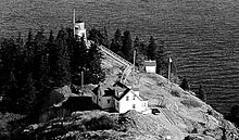
Location Owls Head, Maine Year first constructed 1826 Year first lit 1826 Automated 1989 Foundation Granite Construction Brick Tower shape Cylindrical Markings / pattern white with black lantern Focal height 100ft (30m) Current lens 4th order Fresnel lens[1] Range 16 nm Characteristic Fixed white Fog signal HORN: 2 every 20s USCG number 1-4105 Owls Head Light Station

Nearest city: Owls Head, Maine Coordinates: 44°5′32.058″N 69°2′38.490″W / 44.09223833°N 69.044025°WCoordinates: 44°5′32.058″N 69°2′38.490″W / 44.09223833°N 69.044025°W Built: 1826 Architect: Green & Foster and Jeremiah Barry Governing body: U.S. Coast Guard NRHP Reference#: 78000183[5] Added to NRHP: January 18, 1978  1998 photo
Owls Head Light is a lighthouse located in Owls Head, Maine at the entrance of Rockland Harbor on Western Penobscot Bay. The lighthouse was established in 1826. It is operated by the United States Coast Guard and it is also part of Owls Head Light State Park.
History
The lighthouse was designed by Green & Foster and Jeremiah Barry and constructed in 1826. It is a 30-foot (9.1 m) tall cylindrical brick tower on a granite foundation standing on top a cliff. It has one of the last six Fresnel lenses in operation in Maine.[1]
In 1854, a keeper's house was built separate from the lighthouse. The cottage now serves as Coast Guard housing. A fourth order Fresnel lens, in use until recently, was installed in 1856. A generator house and an oil storage building were added in 1895.
The light station was added to the National Register of Historic Places as Owls Head Light Station in 1978.[5]
References
- ^ a b "Classical Lenses in Operation". US Coast Guard. 2009-08-06. http://www.uscg.mil/history/docs/CG_Classical_Lens_in_Operation.pdf.
- ^ (PDF) Light List, Volume I, Atlantic Coast, St. Croix River, Maine to Shrewsbury River, New Jersey. Light List. United States Coast Guard. 2009. p. 36. http://www.navcen.uscg.gov/pdf/lightLists/LightList%20V1.pdf.
- ^ "Historic Light Station Information and Photography: Maine". United States Coast Guard Historian's Office. 2009-08-08. http://www.uscg.mil/history/weblighthouses/LHME.asp.
- ^ Rowlett, Russ (2009-10-09). "Lighthouses of the United States: Southern Maine". The Lighthouse Directory. University of North Carolina at Chapel Hill. http://www.unc.edu/~rowlett/lighthouse/me2.htm.
- ^ a b "National Register Information System". National Register of Historic Places. National Park Service. 2009-03-13. http://nrhp.focus.nps.gov/natreg/docs/All_Data.html.
Lighthouses of Maine Avery Rock Light · Baker Island Light · Bass Harbor Head Light · Bear Island Light · Blue Hill Bay Light · Boon Island Light · Browns Head Light · Burnt Coat Harbor Light · Burnt Island Light · Cape Elizabeth Lights · Cape Neddick Light · Crabtree Ledge Light · The Cuckolds Light · Curtis Island Light · Deer Island Thorofare Light · Dice Head Light · Doubling Point Light · Doubling Point Range Lights · Eagle Island Light · Egg Rock Light · Fiddler's Reach Fog Signal · Fort Point Light · Franklin Island Light · Goat Island Light · Goose Rocks Light · Great Duck Island Light · Grindel Point Light · Halfway Rock Light · Hendricks Head Light · Heron Neck Light · Indian Island Light · Isle Au Haut Light · Kennebunkport Breakwater Light · Ladies Delight Light · Libby Island Light · Little River Light · Lubec Channel Light · Manana Island Sound Signal Station · Marshall Point Light · Matinicus Rock Light · Monhegan Island Light · Moose Peak Light · Mount Desert Light · Narraguagus Light · Nash Island Light · Owls Head Light · Pemaquid Point Light · Perkins Island Light · Petit Manan Light · Pond Island Light · Portland Breakwater Light · Portland Head Light · Prospect Harbor Point Light · Pumpkin Island Light · Ram Island Light · Ram Island Ledge Light · Rockland Harbor Breakwater Light · Saddleback Ledge Light · Saint Croix River Light · Seguin Light · Spring Point Ledge Light · Squirrel Point Light · Tenants Harbor Light · Two Bush Island Light · West Quoddy Head Light · Whaleback Light · Whitehead Light · Whitlocks Mill Light · Winter Harbor Light · Wood Island Light Portland Head Light
U.S. National Register of Historic Places Topics Lists by states Alabama • Alaska • Arizona • Arkansas • California • Colorado • Connecticut • Delaware • Florida • Georgia • Hawaii • Idaho • Illinois • Indiana • Iowa • Kansas • Kentucky • Louisiana • Maine • Maryland • Massachusetts • Michigan • Minnesota • Mississippi • Missouri • Montana • Nebraska • Nevada • New Hampshire • New Jersey • New Mexico • New York • North Carolina • North Dakota • Ohio • Oklahoma • Oregon • Pennsylvania • Rhode Island • South Carolina • South Dakota • Tennessee • Texas • Utah • Vermont • Virginia • Washington • West Virginia • Wisconsin • WyomingLists by territories Lists by associated states Other Categories:- Buildings and structures completed in 1826
- Lighthouses on the National Register of Historic Places in Maine
- Lighthouses in Knox County, Maine
- United States lighthouse stubs
- Maine Registered Historic Place stubs


Wikimedia Foundation. 2010.