- Moose Peak Light
-
Moose Peak Light 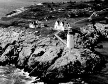
Location Mistake Island Coordinates 44°28′28.487″N 67°31′55.166″W / 44.47457972°N 67.53199056°WCoordinates: 44°28′28.487″N 67°31′55.166″W / 44.47457972°N 67.53199056°W Year first constructed 1827 Year first lit 1851 (current structure) Automated 1972 Foundation Masonry and stone Construction Brick Tower shape Conical Markings / pattern White with black trim Focal height 72ft (22m) Original lens 2nd order Fresnel lens Current lens DCB-24 Range 20nm Characteristic Fl W 30s Fog signal HORN: 2 every 30s Admiralty number J0028 ARLHS number USA-513 USCG number 1-1390 Moose Peak Light is a lighthouse on Mistake Island, just east of Great Wass Island, Maine at the southern entrance to Eastern Bay and five nautical miles southeast of Jonesport. It was first established in 1827. The present structure was built in 1851.
References
- ^ "Historic Light Station Information and Photography: Maine". United States Coast Guard Historian's Office. 2009-08-06. http://www.uscg.mil/history/weblighthouses/LHME.asp.
- ^ (PDF) Light List, Volume I, Atlantic Coast, St. Croix River, Maine to Shrewsbury River, New Jersey. Light List. United States Coast Guard. 2009. p. 16. http://www.navcen.uscg.gov/pdf/lightLists/LightList%20V1.pdf.
- ^ Rowlett, Russ (2009-10-09). "Lighthouses of the United States: Eastern Maine". The Lighthouse Directory. University of North Carolina at Chapel Hill. http://www.unc.edu/~rowlett/lighthouse/me.htm.
Lighthouses of Maine Avery Rock Light · Baker Island Light · Bass Harbor Head Light · Bear Island Light · Blue Hill Bay Light · Boon Island Light · Browns Head Light · Burnt Coat Harbor Light · Burnt Island Light · Cape Elizabeth Lights · Cape Neddick Light · Crabtree Ledge Light · The Cuckolds Light · Curtis Island Light · Deer Island Thorofare Light · Dice Head Light · Doubling Point Light · Doubling Point Range Lights · Eagle Island Light · Egg Rock Light · Fiddler's Reach Fog Signal · Fort Point Light · Franklin Island Light · Goat Island Light · Goose Rocks Light · Great Duck Island Light · Grindel Point Light · Halfway Rock Light · Hendricks Head Light · Heron Neck Light · Indian Island Light · Isle Au Haut Light · Kennebunkport Breakwater Light · Ladies Delight Light · Libby Island Light · Little River Light · Lubec Channel Light · Manana Island Sound Signal Station · Marshall Point Light · Matinicus Rock Light · Monhegan Island Light · Moose Peak Light · Mount Desert Light · Narraguagus Light · Nash Island Light · Owls Head Light · Pemaquid Point Light · Perkins Island Light · Petit Manan Light · Pond Island Light · Portland Breakwater Light · Portland Head Light · Prospect Harbor Point Light · Pumpkin Island Light · Ram Island Light · Ram Island Ledge Light · Rockland Harbor Breakwater Light · Saddleback Ledge Light · Saint Croix River Light · Seguin Light · Spring Point Ledge Light · Squirrel Point Light · Tenants Harbor Light · Two Bush Island Light · West Quoddy Head Light · Whaleback Light · Whitehead Light · Whitlocks Mill Light · Winter Harbor Light · Wood Island Light Portland Head Light
 Categories:
- Lighthouses in Maine
- Buildings and structures completed in 1851
- Lighthouses in Washington County, Maine
- United States lighthouse stubs


Wikimedia Foundation. 2010.