- National Register of Historic Places listings in Saline County, Arkansas
-
 Location of Saline County in Arkansas
This is a list of the National Register of Historic Places listings in Saline County, Arkansas.
This is intended to be a complete list of the properties and districts on the National Register of Historic Places in Saline County, Arkansas, United States. The locations of National Register properties and districts for which the latitude and longitude coordinates are included below, may be seen in a Google map.[1]
There are 17 properties and districts listed on the National Register in the county. One other site was once listed on the Register but have been removed.
Contents: Counties in Arkansas Arkansas - Ashley - Baxter - Benton - Boone - Bradley - Calhoun - Carroll - Chicot - Clark - Clay - Cleburne - Cleveland - Columbia - Conway - Craighead - Crawford - Crittenden - Cross - Dallas - Desha - Drew - Faulkner - Franklin - Fulton - Garland - Grant - Greene - Hempstead - Hot Spring - Howard - Independence - Izard - Jackson - Jefferson - Johnson - Lafayette - Lawrence - Lee - Lincoln - Little River - Logan - Lonoke - Madison - Marion - Miller - Mississippi - Monroe - Montgomery - Nevada - Newton - Ouachita - Perry - Phillips - Pike - Poinsett - Polk - Pope - Prairie - Pulaski (Little Rock) - Randolph - St. Francis - Saline - Scott - Searcy - Sebastian - Sevier - Sharp - Stone - Union - Van Buren - Washington - White - Woodruff - Yell
-
- This National Park Service list is complete through NPS recent listings posted November 10, 2011.[2]
Current listings
[3] Landmark name [4] Image Date listed Location City or town Summary 1 Benton Commercial Historic District July 24, 2008 Portions of the 100 and 200 blocks of N. Main, N. Market, N. East, W. South, and Sevier Sts.
34°33′52″N 92°35′13″W / 34.564444°N 92.586944°WBenton 2 J.W. and Ann Lowe Clary House February 19, 1993 305 N. East St.
34°33′56″N 92°35′06″W / 34.565556°N 92.585°WBenton 3 Gann Row Historic District February 5, 1999 Bounded by Pine, Market, Maple and S. Main Sts.
34°33′35″N 92°35′15″W / 34.559722°N 92.5875°WBenton 4 Gann Building October 21, 1975 218 S. Market St.
34°33′41″N 92°35′16″W / 34.561389°N 92.587778°WBenton 5 Gann House January 2, 1976 S. Market St. Benton 6 Hester-Lenz House February 11, 2004 905 Highway 5, N.
34°36′18″N 92°32′42″W / 34.605°N 92.545°WBenton 7 Hughes Mound Site (3SA11) October 10, 1985 Address Restricted Benton 8 Andrew Hunter House December 12, 1976 West of Bryant on Highway 5
34°37′37″N 92°29′53″W / 34.626944°N 92.498056°WBryant 9 Independent Order of Odd Fellows Building May 26, 2004 123-125 N. Market
34°33′58″N 92°35′16″W / 34.566111°N 92.587778°WBenton 10 Old Benton-Sardis Road Bridge January 24, 2007 North of Highway 183, approximately 1.25 miles east of Pine Haven Rd.
34°33′39″N 92°30′11″W / 34.560833°N 92.503056°WBauxite 11 Old River Bridge 
September 15, 1977 Southwest of Benton at River Rd. and the Saline River
34°32′26″N 92°36′25″W / 34.540556°N 92.606944°WBenton 12 Pleasant Hill Methodist Church June 5, 1991 Junction of Lawson and Lake Norrell Rds.
34°41′47″N 92°36′56″W / 34.696389°N 92.615556°WPleasant Hill 13 Royal Theatre September 27, 2003 111 S. Market St.
34°43′47″N 92°35′18″W / 34.729722°N 92.588333°WBenton 14 Rucker House June 16, 1988 Highway 183 and Gibbons Rd.
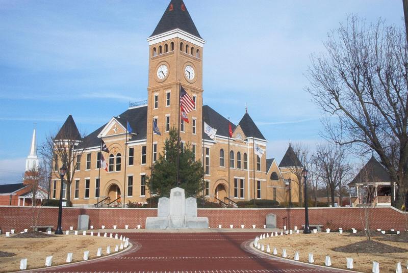
34°33′21″N 92°30′37″W / 34.555833°N 92.510278°WBauxite 15 Saline County Courthouse 
November 22, 1976 Courthouse Sq.
34°33′53″N 92°35′15″W / 34.564722°N 92.5875°WBenton 16 Shoppach House October 10, 1975 508 N. Main St.
34°34′09″N 92°35′23″W / 34.569167°N 92.589722°WBenton 17 Dr. James Wyatt Walton House December 22, 1977 301 W. Sevier
34°33′52″N 92°35′24″W / 34.564444°N 92.59°WBenton Former listings
Landmark name Image Date listed/removed Location City or Town Summary 1 North Fork Saline River Bridge Listed May 26, 1995
Removed September 23, 2011Highway 9 over the Saline River
34°46′47″N 92°45′28″W / 34.77972°N 92.75778°WParon Historic Bridges of Arkansas MPS See also
- List of National Historic Landmarks in Arkansas
- National Register of Historic Places listings in Arkansas
References
- ^ The latitude and longitude information provided in this table was derived originally from the National Register Information System, which has been found to be fairly accurate for about 99% of listings. For about 1% of NRIS original coordinates, experience has shown that one or both coordinates are typos or otherwise extremely far off; some corrections may have been made. A more subtle problem causes many locations to be off by up to 150 yards, depending on location in the country: most NRIS coordinates were derived from tracing out latitude and longitudes off of USGS topographical quadrant maps created under North American Datum of 1927, which differs from the current, highly accurate GPS system used by Google maps. Chicago is about right, but NRIS longitudes in Washington are higher by about 4.5 seconds, and are lower by about 2.0 seconds in Maine. Latitudes differ by about 1.0 second in Florida. Some locations in this table may have been corrected to current GPS standards.
- ^ "National Register of Historic Places: Weekly List Actions". National Park Service, United States Department of the Interior. Retrieved on November 10, 2011.
- ^ Numbers represent an ordering by significant words. Various colorings, defined here, differentiate National Historic Landmark sites and National Register of Historic Places Districts from other NRHP buildings, structures, sites or objects.
- ^ "National Register Information System". National Register of Historic Places. National Park Service. . http://nrhp.focus.nps.gov/natreg/docs/All_Data.html.
U.S. National Register of Historic Places Topics Lists by states Alabama • Alaska • Arizona • Arkansas • California • Colorado • Connecticut • Delaware • Florida • Georgia • Hawaii • Idaho • Illinois • Indiana • Iowa • Kansas • Kentucky • Louisiana • Maine • Maryland • Massachusetts • Michigan • Minnesota • Mississippi • Missouri • Montana • Nebraska • Nevada • New Hampshire • New Jersey • New Mexico • New York • North Carolina • North Dakota • Ohio • Oklahoma • Oregon • Pennsylvania • Rhode Island • South Carolina • South Dakota • Tennessee • Texas • Utah • Vermont • Virginia • Washington • West Virginia • Wisconsin • WyomingLists by territories Lists by associated states Other  Category:National Register of Historic Places •
  Portal:National Register of Historic Places
Municipalities and communities of Saline County, Arkansas County seat: Benton Cities Benton | Bryant | Haskell | Shannon Hills

Towns CDPs Avilla | East End | Hot Springs Village‡ | Salem
Unincorporated
communitiesFootnotes ‡This populated place also has portions in an adjacent county or counties
Categories:- Saline County, Arkansas
- National Register of Historic Places in Arkansas by county
-


Wikimedia Foundation. 2010.